It is a known issue that most drivers don’t respect most traffic laws. Recently a reader wrote to us desperately trying to figure out what can be done to make drivers follow the law, specifically stopping for pedestrians at crosswalks along the newly reconstructed Central Corridor.
Nobody talks about this major problem, yet we have people jumping up and down to chastise bicyclists for selectively following the one law drivers seem to like (red lights). First, let’s get the excuses out of the way. You know, the “I didn’t see you patiently (or angrily) waiting to cross the street” – in other words, “I am either lying or not paying attention.”
There are two ways to solve the problem: one involves a combination of frequent enforcement and expensive tickets. The other is street design: we need to plan and engineer transportation facilities that are safe and comfortable for people to use.
The reconstruction of University Ave is a major missed opportunity and a case study in why we need pedestrian planners. Somehow we designed a major transit corridor to be dangerous for transit users and anyone else not in a motor vehicle. Every bus trip requires you to cross the street at least once — in this case twice because of the insane width of the stroad — so transit can’t be useful if you have to risk your life to access it. The corridor is full of unsignalized crosswalks that are ignored by drivers and signalized crosswalks that make it impractical to cross safely and legally.
If drivers won’t stop for pedestrians at officially recognized locations (marked crosswalks) then people will attempt to cross at unmarked crosswalks, which is even more dangerous because the design has incorporated fences, curbs and other barriers to prevent jaywalking (a derogatory term invented by the car lobby to promote their product). That means if you see a gap in traffic and run across you might be unable to step into safety.
Painting unsignalized crosswalks can be an effective tool in dense business districts where plenty of people are walking around and cars are driving slowly. However, pedestrians should never be expected to cross more than one lane of moving traffic between safe spaces. With a second lane drivers are much less likely to respect the crosswalk, and you expose people to the “double threat”, where one driver stops but traffic in the adjacent lane keeps going. Being struck at such a high speed means you are very likely to die.

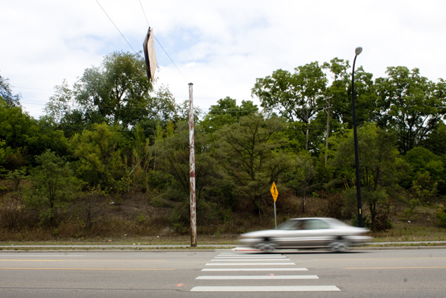
What is the point of this crosswalk? Does anyone really think that car is going to stop?
The design is also very dangerous for bicycle riders due to the high traffic speeds, very wide lanes, lack of even basic bike lanes, and the constant shifting of the lanes around intermittent car parking zones that are never used. The stress of biking on stroads like this one — and the fear of being struck with a 95 percent chance of being killed — causes many people to bike on the sidewalk, which they often don’t realize is even more dangerous.
- Approaching a driveway with no sight lines and no escape route.
- Proper cycling technique: this person is forced to control two lanes to prevent close passing at high speeds.
Both cities always say they want to increase biking and walking, and the street was just reconstructed over the past few years. So why was this such a missed opportunity?
Part of the answer is politics: many things were done to placate drivers. The other part is business as usual at MnDOT. Traffic engineers plan streets to accommodate expected peak hour traffic volumes assuming an increase in traffic over several years. That’s problematic for several reasons:
- The rush hour represents less than 12 percent of a normal week, so you’re wasting a lot of valuable space almost 90 percent of the time.
- Designing streets to have excess traffic capacity just attracts more traffic. It’s the theory of induced demand.
- The number of car trips is declining in all large North American cities as more people use other modes. Putting cars first is unfair to others who must fight for the leftover space instead of being a part of the decision process. That’s why we hear that “there’s no room for a bike lane”; but there’s always room if you don’t preemptively insist on prioritizing cars.
- Anytime a street has excess capacity, there will be reckless behavior such as driving too fast (speeding), putting many lives at risk and scaring everyone else. That’s not conducive to pedestrian activity and certainly doesn’t support a major transit corridor.
- Contrary to popular myth, drivers contribute very little economically to the places they drive through. So if you slow their trip a little bit or nudge them to drive elsewhere, who cares?
All of this applies to University Avenue: we should remove one more lane on each side to make the corridor safer. There is no reason to over-build streets except to placate the drivers who run the political system. [I am betting there will be no signal priority for transit vehicles, even though there certainly should be, and there will be many car-train conflicts everywhere left turns are permitted.]
Experience in many cities shows that, while you can put all the warning signs in the world, long crosswalks are still too dangerous. Concrete median refuge islands (better or cheaper) should be installed between lanes, or a traffic signal installed to bring vehicle traffic to a complete stop (red signal). The city of Cambridge has a model traffic calming program with many examples such as raised crosswalks, concrete diverters and cycle tracks. I don’t recommend flashing yellow “beg button” pedestrian-activated warning lights since they are usually ignored by drivers, but installing a simple stop sign can be surprisingly effective if drivers are failing to stop without one.
Some solutions for University Avenue might include stop signs, more signals, speed cameras, raised crosswalks and perhaps photo enforcement of crosswalk violations. Most importantly, even if the powers that be refuse to change anything, University Avenue should be consistently held up as a case study of what not to do going forward.
The same issues are present on Minnehaha Avenue. Are the City of Minneapolis and Hennepin County listening?
I have not tried to cross University Ave specifically, but on other busy, urban streets, it seems that drivers are significantly more likely to stop at a marked crosswalk than an unmarked one. In fact, the University Ave design does integrate refuge islands, so you are truly only crossing one direction at a time. One’s still going to have to be assertive, but I don’t think it’s a terrible design. The main strike for me is that St. Paul (like Minneapolis) insists on using the invisible transverse line crosswalk design instead of the more visible, international standard zebra striping.
Permanently installed stop signs would be very impractical. Obviously, they snag traffic on high-volume streets, but they also fail to help cross traffic (pedestrians, in this case), when they’re just an “obstacle” more than a traffic-control device; drivers are more focused on stopping just enough than something they might be stopping for.
A device similar to a stop sign but less impractical at times when no pedestrians are present is a HAWK Crossing, or the European PUFFIN crossing. HAWKs might have been a good choice for University.
It seems to be true that drivers are more likely to stop an marked crosswalks but it still happens on average less than half of the time. While I agree that it’s a poor choice of stripe pattern, each crossing is still plenty visible with giant yellow warning signs. All of these crossings present two lanes of speeding traffic to cross without any help.
The rest of your comment is sadly a reminder of how car culture makes even pedestrian advocates think cars have to come first. Why? If cars continue to terrorize people by blatantly ignoring rules meant to tame them, why do we just have to put up our hands and give up? Why do cars continue to get priority everywhere and everyone else is ignored? The yellow flashing lights accompanied by a “beg button” — please, please stop for me, please! — don’t work very well, and implicit in their use is the idea that there’s a widespread problem we don’t really want to address. Just like sharrows. You should not have to be an “assertive” risk-taker to get from A to B.
Stop signs are a very obtuse tool for any vehicular mode. I oppose them with far more vigor when used unnecessarily on bike-only facilities. The reality is that they’re used in North America as an awkward way to force cars into some compliance. They’re almost unheard of in parts of Europe.
Rather than stopping for nothing — and significantly disrupting traffic — it makes more sense to establish a firm expectation that you stop when there is something, like a red light, pedestrian, etc. Of course, the best way to do that is to have a culture of yielding to pedestrians in all crosswalks. Short of that, something like a HAWK Crossing seems like an approach to achieve the same goal, a bit more brute-forced.
One solution is to restore on-street parking to the entirety of University. My first trip down the avenue following construction left me thinking the physical barrier of light rail and no parking along most of the roadway left the lanes of traffic kind of funneled, if you will, almost like you should drive faster. The street feels like it is less for people and more for mechanized travel (rail or vehicle). Restoring on-street parking would humanize the street, provide a better buffer between moving traffic and pedestrians, help businesses, slow traffic, and ensure these crosswalks only require crossing one lane of traffic. My understanding is this is not entirely off the table.
Bottom line – why invest $1 billion in transit but make it no more difficult to drive on the street?
Sam:
I’d ordinarily agree that parked cars would help slow down traffic, but the sidewalks are already extremely narrow, due the space needed for the light rail and travel lanes. I can’t imagine any way to fit parking into most of the corridor without sacrificing one of the travel lanes. And if you’re doing that, personally, I’d rather have that space go to a bike lanes and wider sidewalks.
I absolutely mean reduce through lanes from two to one and not sacrifice existing sidewalks. I don’t have a solution for bikes – wish I did.
How about a bike route/boulevard on a parallel street?
The places people want to go are on University.
The challenge of complete streets, especially when the transit ROW is LRT. Really tough to fit everything in if you don’t have 150 ft of public space and having 2 travel lanes is a must. That said, seems like the 120′ they have throughout almost all of University Ave should be able to fit a solid cycle track, single lane of travel in each direction (with room for a gutter pan), a wide sidewalk, a 4′ median with trees separating the thru lane from the cycle track, and still have some space for on-street parking on one side. Does anyone have a link to the actual street cross-section?
So you cut over a block to get to your destination.
I mean, a perfect world might allow for safe, comfortable biking on every street. But we’re much too far from that to object to improvements that are less than perfect.
Lately I’ve been biking from my place downtown to my mother-in-law’s place in Richfield. Going right down Lyndale would be pretty close to a straight shot, and I could do that if I wanted. But there are fewer cars and the ride is nicer two blocks over on the Bryant Ave bike boulevard, which works great (and provides pretty good access to stops along Lyndale too).
Although it could use better connections to more convenient places to cross under 62.
I do really agree with Walker’s basic point, though: we should, as a starting point at least, try to accommodate bicycles safely on the main street. Alternate parallel routes are quickly becoming the go-to solution for Minneapolis to sort-of-accommodate bikes, but not inconvenience autos in the least. (No bikeway on Lake Street, no bikeway on Lyndale, and they just recently decided to put the Penn bikeway on Oliver or Queen instead, having bicycles wind back to Penn for one block to cross Minnehaha Creek.)
If we didn’t have freeways or other connectivity problems — or if we funded bike facilities the same way we do auto facilities — we’d be fine. But as you experienced on Bryant, everything must come to an end, and the Bryant bikeway ends at 58th Street. You must go to Lyndale to get across the Crosstown Highway. The Oliver bikeway will have the same issues, at both Crosstown and Minnehaha Creek.
Even for the majority of Bryant, traffic control is less favorable — there are well over a dozen stop signs, and the lights are slower for Bryant than they would be for Lyndale.
And for what it’s worth, St. Paul is already planned an alternate parallel route on Charles Ave. But I still think this is a far cry from a high-quality facility on University.
Cutting over a block means crossing the unsafe, busy street at least twice. That sure feels more dangerous than just riding with traffic on the busy street, and it’s just about impossible to do either with kids or slow riders on a bike, or as a pedestrian who is slow (such as an elderly or disabled person, or again someone with kids with them, especially if it’s more than one child you’re trying to herd)
Extending the sidewalks would be great, since yes it is a skinny sidewalk also sorely lacking bike parking including bike racks and on-street bike corrals just off University on intersecting streets which would only displace *a* parked car on any given block and offers parking for a dozen or so people. If St Paul won’t do it on there side Mpls needs to step up and set an example. I’d like to see Mpls at least turn our stretch of University just before entering St Paul have the right lane converted to a buffered bike lane. Whether it ends at the St Paul border can be up to them. I see nothing wrong with expecting St Paul to be expected to move into the 21st century. As for University being dangerous, it can be safe, but only if you’re a vehicular cyclist occupying the middle of the right hand lane. It’s the only way I’ve ridden it and the only way I would in its current state.
As for the HAWK route it would need to use flashing red lights, not flashing yellow ones.
Has St Paul even zoned the corridor for denser urban development so that apartments can be built instead of the huge strip-malls now there where not a single person lives? I think with enough dense urban infill you’ll see a good increase in the number of pedestrians, cyclists, and motorists slow down the deadly speeds at which cars and trucks are moving. I’m sure we’ve all seen the study showing the huge jump in ratio of deaths to injuries when crashes, not accidents, involving motorists and pedestrians occur at 25 vs 35 MPH, where pedestrian fatalities double from the 25 to 35 MPH jump in speed. The question to be posed to those responsible for the high speed limit is, “Why do you want to ensure that twice as many pedestrians needlessly die next year than would have otherwise?” https://www.aaafoundation.org/sites/…/2011PedestrianRiskVsSpeed.pdf
Excellent comments. However…
“As for University being dangerous, it can be safe, but only if you’re a vehicular cyclist occupying the middle of the right hand lane.” Safe is a bit of a relative term here. Even as a vehicular cyclist I find it quite dangerous and scary. I don’t think I would go near saying it can be safe. Even at that, vehicular cycling ignores 95% of the population.
Here is a link to the city’s rezoning study of University Ave. http://www.stpaul.gov/index.aspx?NID=3881
A map of the previous zoning,
http://www.stpaul.gov/DocumentCenter/Home/View/14154
Here is a map showing how it is today.
http://www.stpaul.gov/DocumentCenter/Home/View/17126
You can see huge swaths of T4 zoning, That’s traditional neighborhood (mixed uses). It allows up to ten stories. Much of the eastern area was to be higher density, but the neighborhood resisted that. All in all it’s a huge improvement.
Saint Paul’s T4 District allows heights of 75 feet. It can be more but requires increased setbacks based on the amount of additional height and, in some cases, a conditional use permit. It is unlikely you will see many new 10-story buildings particularly when the City has already signaled that it will cave on questions of density and height. All you have to do is check the difference between the possible development views and language included in the Central Corridor Development Strategy (now part of the City’s comp plan) and what is allowed in T4 Districts (the main dimensional standards for T4 are found at http://library.municode.com/index.aspx?clientId=10061.)
I agree we probably won’t see very many 10-story buildings. But let’s give the city some benefit of the doubt. This isn’t Grand Avenue. Episcopal Homes new building will be 7 stories and 78 feet tall. They required a CUP and were given it with little fanfare. University Avenue isn’t going to become the next Sheikh Zayed Road or NYC’s 57th Street. But we’ll get a lot of new infill in the coming years. Even a 3 or 4 story mixed use project is still an improvement over what is there right now.
I also don’t think we’ll see the ‘Manhattanization’ of University Avenue, the argument used by neighborhood organizations to push the City to drop heights and densities recommended in the Central Corridor Development Strategy, now part of the City’s comp plan. I guess I’m less willing, though, to give the City a break when (i) it did cave to the argument about Manhattanization, creating an inconsistency between the City’s comp plan and land use regulations, about the only true legal non-no in the Metropolitan Land Planning Act, (ii) in addition to messing with height, the City dropped the FAR proposed for T4 to 0.5 (I don’t think anybody views something like the CVS at University/Snelling as new urbanism or even ‘traditional’), and (iii) the City recently restricted new auto body shops to T4 districts because nobody else wanted them and, I guess, the City didn’t pick up on the irony of concentrating such an auto-related use in districts that are intended for walkable, pedestrian-oriented mixed use.
That was my thought too. The main thing that would slow traffic is more people, and much of the corridor is still pretty deserted.
Jeremy, great great post.
Quote of the day: “Somehow we designed a major transit corridor to be dangerous for transit users”
Of your solutions I would put raised crossings at the top of my list. These seem to work extremely well for making drivers more aware of crossings, slowing down overall, and stopping at the crossings when someone is in it. They also remain much more clear of rain, snow, and ice which improves comfort and safety. I would think the biggest concern would be how well plows deal with them, even with very slight grades up, though this doesn’t seem to be a problem in northern Europe.
I’ve often thought that simply moving the parking/turn lanes over one lane and putting in a cycle track on each side would be the solution to many other problems. A single motor lane would slow traffic and make crossing easier, safer, and more comfortable. The overall street, and primarily the sidewalk and businesses, would be more pleasant.
With such close proximity to 94, are two vehicle lanes really necessary for accessing local businesses?
HAWK’s seem more appropriate for occasional or unexpected crossings. I think here they would just clutter things up more than they already are. I don’t think stop signs would be the ticket either. I would think that raised crossings and slower speeds would do the trick. Single traffic lane would certainly help considerably. I’d hesitate to add any more clutter of any sort, but perhaps flashing pucks in the crossings similar to those in Marco Island might help?
Even with the LRT construction going on, there are still some segments of University Ave that are over 20K daily traffic, over the “road diet” threshold.
If you wanted to get the longer-distance traffic off University, you’d have to address the congestion and lane continuity issues on I-94. This would be a case where a “trade” may be worthwhile…add a lane to I-94 (or at a minimum make it a consistent 8 lanes instead of having the lane drops between 35W and 280 and especially at Snelling Ave) in order to reduce University Ave to 1 lane each way.
Froggie is right — there are sections over 20k autos a day, and I don’t think it’s 94 reliever traffic. The section between Snelling and Lexington is extremely auto-oriented; it could just as easily be Cedar Avenue in Apple Valley. Obviously the goal is to move away from this development and eventually replace it with more urban development, but it’s worth remembering that the land use today does attract cars, and the road accommodates those cars. That’s not to say the road must do that, but I think it’s a fundamentally different consideration than a road handling overflow freeway traffic that could be routed back to the freeway.
I’m also wondering how well on-street parking works with a single travel lane and a hard median. When I park on a busy street like Nicollet, cars can easily overtake me in the center turn lane. Even if they were patient enough to wait, they often follow too close to allow me to back into a parallel parking spot. I would envision parallel parking on a single-lane, 20k ADT road to be very stressful and unattractive.
I think what you’re getting at is that there’s not much hope for traffic calming with two lanes. The needs of traffic volume throughput and safe streets are inherently conflicting.
Raised crosswalks are great for many reasons and are common in cities like Cambridge, Boulder, Berkeley and many similar progressive places. Snow removal is not a problem. http://www.cambridgema.gov/CDD/Transportation/gettingaroundcambridge/byfoot/pedestriansafety.aspx
When I had a conversation with an engineer last week about 66th Street in Hennepin County, I asked about raised crosswalks for the crosswalks at the Portland Ave and Richfield Parkway roundabouts. I wasn’t told that it was impossible, exactly, but their reaction suggested extreme reluctance to even consider that. And that’s in an unusual situation, where cars have to slow down to 15-20 mph anyway. Getting a raised crosswalk on a mainline 30 mph section of a County State Aid Highway would be even harder, since cars would have to slow to 10-20 mph for no other reason than the crosswalk.
I’d support raised crosswalks, but I think a HAWK crossing is a much easier sell for a County State Aid Highway. (And to whoever mentioned red vs. yellow lights, a HAWK crossing does indeed use red lights. It’s essentially like a traffic signal, except that it quickly turns from solid red to flashing red, so mainline traffic may proceed after the pedestrian has left the crosswalk.)
But that’s the problem, right? We need cars to slow down. If they aren’t physically forced to slow down they just won’t. That’s why traffic calming even exists, though I wish we didn’t need it.
I’m curious why you think cars will respect a flashing red light at a crosswalk but not a flashing yellow light?
You should look at the animation of how a HAWK works. To most drivers, I believe they would treat it like a traffic signal, since it goes yellow and then red in the same fashion.
From a legal standpoint, this also has a little more bite, since ignoring a red light would be failure to obey a traffic control device and failure to yield to a pedestrian in crosswalk. Flashing yellow lights legally just mean “use caution”, so it’s harder to get he meaningful moving violation tied to that.
You can also just do a straight-up light, although I think engineers prefer the HAWK nowadays. Bloomington uses lights for crossings on busier streets (see East Old Shakopee at 10th Ave).
It would be interested to study these different treatment and compare compliance rates.
Somerville, Mass., where I used to live, uses has setup a few crosswalks with traditional traffic signals that flash yellow but can be instantly changed to red with the push of button.
Does anyone know or has anyone checked how the HAWK signals on Hwy 23 in St. Cloud are working? That’s a road with several characteristics similar to University Ave.
It’s really not important how much traffic is carried today. Focusing on daily vehicle counts is what keeps causing these disasters everywhere. Part of the point of building transit lanes is to transform the corridor away from auto-centric to a more peaceful place. Light rail is far more efficient than cars, but the fact that we still have transit advocates saying we “need to accommodate” large numbers of cars is cause for frustration. (For what it’s worth, the typical threshold for traffic engineers to agree to a 4-3 lane conversion road diet is 28,000 vehicles per day.)
On the other hand, I’m glad we’re thinking about steets as the network they are. However, there is no way I could ever get behind widening a freeway. Aside from induced demand (case closed!) … Portland build it’s entire bike network for the cost of adding one freeway lane for one mile. For that price we could have another LRT line. But more importantly, the only way you’ll ever reduce traffic is to make driving more difficult/expensive AND provide high-quality alternatives like fast, frequent trains and buses with either grade separation or good signal priority. They have to work together. You could make the nicest transit line and people won’t use it if driving is still cheap and easy.
p.s. I realize some of you may be thinking more about what is politically feasible in a culture dominated by auto drivers. I tend not to operate in that realm because the threshold is so artificially low. Instead I like to push the envelope in order to move the discourse in a progressive direction.
Where did you get that 28,000 figure from? Everything I’ve read pegs it between 15K and 20K, with the latter being the more popular figure.
Huh:
http://www.twincities.com/stpaul/ci_24357316/university-avenue-group-study-cutting-traffic-lanes-adding
I think the cross section for most of University looks like: http://www.arboretum.umn.edu/UserFiles/File/Water-Climate%20Summit/Mike%20Herman.pdf (p 6)
I think it would be totally possible to use the 11 ft of traffic lane and ~2 ft of gutter pan as a 4-5 ft bicycle path against the sidewalk and 8.5′ parking lane. Take half a foot from the thru-lane. Put painted pedestrian median at intersections in the 8.5′ space where a car would be, shortening the crossing gap. Everything is narrowed down and thus slower.