“Where did that un-heard-of quantity of water demanded by the proposed explanation come from in so short a time?”
J Harlen Bretz (1969)
Introduction
According to Dakota legend, Minnesota was once the scene of a big flood. The Unktahe water monsters “were called upon to flood the land and cleanse it of the people’s disrespectful actions” (Westerman and White, 2012, p. 21). What follows is one such example of a flood in prehistoric times.
Highland Creek is so small that I didn’t even include it in the streams chapter of my 2009 book, Subterranean Twin Cities. But it turns out that it has a big secret, revealed here for the first time: It was once the highest volume stream in the city of St. Paul— larger than Phalen Creek or Trout Brook. The flood of water the creek briefly experienced in prehistoric times must have been enormous.
Charlie Evans, of St. Paul Public Works, assembled materials for the first biography of Highland Creek, which I shall attempt to write here. We did not find the name “Highland Creek” on historical maps, however, so it’s being presented here for the first time. The stream is so obscure, even to residents of Highland Park, that I will first describe its original, natural course in terms of today’s landmarks. But it should be understood that the stream itself has been repeatedly diverted, as described below, so the water no longer follows this continuous path (Figure 1).

Beginning in a former wetland near the north edge of what is now the Highland National Golf Course, Highland Creek flowed south, entering a shallow ravine that can still be seen as a chain of ponds on the golf course. At the 18th Hole, it crossed under Hamline Avenue into the tree-lined ravine at Beechwood, flowed under Edgcumbe Bridge and into what had been Highland Lake. At the south end of the former Highland Pool, it entered a buried pipe that runs under Circus Juventas, emerging in the deep ravine across from Mickey’s Diner, on Fort Road — hereafter called “Mickey’s Ravine,” for convenience. From there it flowed under Fort Road by a stone culvert and entered a lower ravine in Kipps Glen Terrace Addition. It flowed under the railway trestle (later embankment) of the Ford Spur (a sidetrack which led to the Ford Motor Company plant in Highland Park), through a sandstone gorge, to the Mississippi River bottomlands, where Lake Crosby drained into it. Quite a journey for a stream just over a mile and a half long!
Following the course of the stream on foot recently, however, I found that Mickey’s Ravine is far wider than expected. This phenomenon is what geologists call an underfit stream. What could have carved this giant ravine, if the present stream was not responsible? While there are many other divots along the miles of bluffs here, they are usually much smaller and due to erosion by flowing springs (Brick, 1997).
Emerging from the Mists of Prehistory
Highland Creek is depicted on Thompson’s 1839 map of the Fort Snelling Military Reserve, where it can be seen flowing through a deep ravine (Figure 2). An early settler lived nearby: “W.G. Carter, or as he was called, ‘Gib’ Carter, lived on the Fort Road and died there in 1852. He came from Virginia” (Newson, 1886, p. 47). Carter was one of the original signers of the memorial to Congress drafted in 1848 for organization of the Minnesota Territory (Anon., 1898). Carter’s house sat along what was an earlier alignment of Fort Road, connected to the west by a road running up through Mickey’s Ravine. In the 1867 Andreas Atlas of Ramsey County, Carter’s Road is depicted in the ravine, connecting Fort Road to the stub end of what is now Montreal Avenue, which was not graded to connect directly with Fort Road until years later. In 1887, Reserve Township, which contained the Highland Creek watershed, was annexed to the city of St. Paul (Empson, 1973) (Figure 3).


Lake Highland and Its Descendants
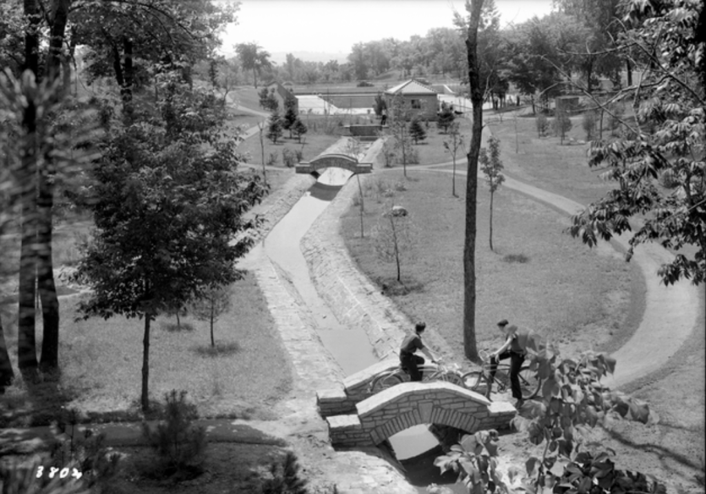
In 1925, Highland Park (the park itself, not the neighborhood) was officially dedicated, and in the following year, Highland Creek was dammed back to form Lake Highland. According to George L. Nason’s newspaper column, “Visiting Around St. Paul Parks,” “The Park bureau tried to name it Lake Highland, but boys soon called it the Highland swimming hole” (Nason, 1932). “The artificial lake will be 500 feet long and 100 feet wide and will be fed by springs” — equivalent to four Olympic-sized swimming pools, but only 3½ feet deep. The springs are likely those belonging to the line of springs known informally as the “Diamond Necklace” (Brick, 1997). But since groundwater is cold, this could make the pool uncomfortably chilly. A dock was built for fly casting and the lake used as a skating rink in winter (Figures 4, 5).


The soil removed to create the swimming hole in 1926 was dumped into the capacious Highland Creek ravine south of Montreal, until 40 feet of fill had accumulated, forming the plateau on which Circus Juventas was later built (Figure 6). Before dumping the fill, a 36-inch diameter concrete pipe was laid down, which received swimming pool drainage — the original Highland Creek.

But, “the draining of surface water into the pool and its asphalt lining were judged bad features” (Anon., 1935), so when the WPA rebuilt the swimming pool in concrete in 1936, it was hooked into the city water supply and chlorinated. While the size was reduced to 60 by 120 feet, this concrete pool was still said to be “the third largest in the country” (Anon., 1937) (Figure 7).

In 1951, the swimming pool outlet was disconnected from the 36-inch concrete pipe in Mickey’s Ravine and diverted to the Montreal sanitary sewer.
The Highland Creek headwaters, draining to Highland Lake, was depicted in a St. Paul Public Works surveyor’s fieldbook from 1912 (Figure 8). In 1936, the landscaping associated with the WPA project involved lining the stream bed with concrete and building four stone footbridges and 12 dams (Figure 9). The footbridges are gone and the concrete lined stream bed was removed but the inlets and outlets still remain in this shallow ravine.
The Highland Park Aquatic Center, featuring the third and present pool, was built south of Montreal, in 1976.

Historically, many surface streams in what are now urban areas were buried, routed into culverts over time, the ostensible reason was often the prevention of flooding. Perspectives have changed, however, and many of these buried streams are now being “daylighted,” or restored to their former condition, in the interest of creating amenities. The policy of the Capitol Region Watershed District, for example, is to “Bring water back to St. Paul.” “The District will work to restore/re-create water resources that have previously been lost or buried. This strategy includes bringing water back to the consciousness of the community through increased awareness, connection, and access to water.” Listed as one of the plan’s goals is to “Investigate and pursue opportunities to restore portions of historic streams.”
Charlie Evans, of St. Paul Public Works, whose research was essential to writing the present article, has identified a daylighting candidate better than any other. The upper course of Highland Creek from Beechwood to Montreal, is now dry. The stream, collecting golf course drainage, was diverted underground into culverts, but the natural habitat and WPA stone structures still exist in the wooded ravine along Hamline. A comparatively modest expenditure could reroute this water back into its natural surface channel. Because the stream is within park boundaries, no expensive land acquisition or construction would be required. (We plan a future piece to cover this topic separately.)
Historically, the hill upon which the Highland Pavilion stands, which towers over Mickey’s Ravine, was part of C.W. Youngman’s Addition to St. Paul (1886), and there were even houses here at one time. Summit Avenue South ran alongside the stream itself. Houses can still be seen in Mickey’s Ravine in a 1923 aerial photo, but as of 1927, “all streets and alleys in C.W. Youngman’s Addition” were vacated (City Council Minutes). By the time of a 1937 aerial photo, no structures are visible in this location.
In its lower course, however, Highland Creek passes through a densely residential area. On a 1912 plat, the stream is depicted flowing through Kipp’s Glen Terrace Addition to St. Paul (Figure 10). Journalist Oliver Towne referred to this neighborhood as the Family Valley, owing to its interrelated, tight-knit families (Towne, 1959).

The Crosby Connection
Highland Creek has been diverted at three places along its former course. The upper third (headwaters segment), running from the northern edge of Highland National Golf Course to Montreal Avenue, was diverted when Lake Highland was excavated. The middle third, extending from Montreal to Fort Road — including Mickey’s Ravine — was diverted at Fort Road to where it joins drainage from the upper third and continues downhill. The lower third, from Fort Road to Elway Street, only carries local runoff nowadays. While formerly running through the backyards of the houses along Ivan Way, it now flows in a culvert under the Ford Spur, built as a high trestle over the ravine in 1923. In 1931 Kipps Glenn and the trestle were filled in at the same time to form a solid embankment. Nowadays, the stream reemerges from this embankment into a ravine behind the Crosby Pointe condos, diving underground again to cross under Shepard Road.
The Highland Creek outfall, a 60-inch concrete pipe, reunites these three strands (upper, middle and lower) before discharging to the river bottoms at Elway Street, where the stream meanders lazily eastwards for another half mile alongside the Interstate-35 East bridge before joining the Mississippi River (Figure 11a and b). On the bottomlands, the stream is augmented by drainage from Crosby Lake. A 1920 surveyor’s fieldbook depicts the Crosby Farm house and other structures on the banks of Highland Creek (Figure 12).


The Cretin Ice Bowl, Mickey’s Ravine and the Great Flood
There’s no better way to get a sense of how “underfit” present-day Highland Creek is — how much smaller than the valley it is supposed to have carved — than by visiting the stone culvert, constructed of Platteville Limestone, across from Famous Dave’s on Fort Road (Figure 13a). The arch is 3 feet across, built as a culvert to carry the stream under the street. Now sealed, the waters were diverted to a pipe running under Fort Road to Montreal Avenue about 1931. Compare that diminutive arch with the enormous width (400 ft) of Mickey’s Ravine, through which the stream flows (Figure 13b). And that ravine is much smaller than it was in the historical past, because demolition debris has been tipped over its sides for many years: bricks, concrete slabs, etc. At the head of the ravine sits Circus Juventas on a plateau of filled land 40 feet thick. Indeed, an 1896 topographic map shows Mickey’s Ravine extending even further, all the way north past Montreal. So how could this minuscule underfit stream have carved such a giant ravine? And if alternatively, a flood carved it, where did all that water come from?


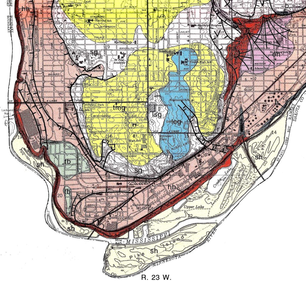
An answer is suggested by the 1992 surficial geology map published by the Minnesota Geological Survey (Patterson, 1992) (Figure 14). This map shows glacial lake sediments (colored blue) stretching from what is now Cretin-Derham Hall south to the Highland 9-Hole Golf Course. The map key describes these as “deposits of a former lake that may have been partially confined by stagnant ice.” This north-south elongated lake, roughly the size of Lake Phalen, formed in likely what was a former ice-block depression of the Grantsburg Sublobe of the last ice sheet. Since the rim of the “bowl” nowadays appears topographically incomplete, it may be that the lake was confined by walls of “stagnant ice” on those other sides. And judging from the elevations involved, the lake could have been as much as 100 feet deep. At some point, the ice wall on the east side could have collapsed or floated up, catastrophically releasing the lake volume all at once. This could have carved the hachured “meltway” depicted on the geology map, leading from the lake down through Mickey’s Ravine. This flood, or multiples of it, could have carved the ravine through solid rock. Downstream from the ravine, the 1992 bedrock geology map (Mossler & Bloomgren, 1992) shows an underlying gorge carved into the St. Peter Sandstone near the Crosby Pointe condos.
The best local example of this phenomenon, but on a much grander scale, is Glacial River Warren, the predecessor of the present-day Minnesota River. The Minnesota River is today an underfit stream flowing through a wide valley that it did not carve in its present state. Instead, about 10,000 years ago, Glacial Lake Agassiz, an enormous lake stretching well up into Canada along the axis of the present Red River lowlands, and much larger than the present Great Lakes, gave way and its water drained catastrophically to the south and east.
In the western US, there are more examples, even grander, of outburst floods. In Montana, the Missoula floods, Glacial Lake Missoula drained catastrophically to the Pacific Ocean, carving the Columbia River scablands of Washington State along the way, as revealed by famous geologist J Harlen Bretz (quoted in the epigraph above) in 1969. This would make Mickey’s Ravine a miniature Grand Coulee (Bretz, 1969). Of course, the volume of our Highland Creek outburst was minuscule by comparison, yet larger than the ordinary flow of even our largest present day city streams.
After the prehistoric flood, Mickey’s Ravine was likely occupied by a small waterfall, like that seen in Hidden Falls Regional Park today, even into historic times, though I have not come across any accounts of it in the early travel literature. But the Highland Creek gorge is much wider than the narrow Hidden Falls gorge— an amphitheater compared to a slot canyon — and is associated with a stagnant ice lake, attesting to its different origin.
Conclusion
This article presents the first biography of Highland Creek, with its rambunctious childhood. Examination of the stream reveals evidence of a hitherto unknown prehistoric flood in St. Paul. As a disclaimer, the Highland Creek flood is conjectural and provisional. The Minnesota Geological Survey is preparing an updated edition of its 1992 geologic atlas, and perhaps more evidence will be forthcoming.
Acknowledgements
Thanks first and foremost to Charlie Evans, St. Paul Public Works, and to Russ Hanson, who has researched Minnesota territorial road history for more than 30 years.
References
Anon. (1898) Corner Stone of the New Capitol to be Laid Today. St. Paul Globe, July 27
Anon. (1926) Artificial Lake to be One Feature at Highland. St. Paul Pioneer Press, January 3
Anon. (1935) Highland Pool Work to Start. St. Paul Pioneer Press, October 27
Anon. (1937) Big Highland Park Pool to be Dedicated Saturday. St. Paul Dispatch, June 24
Bretz, J.H. (1969) The Lake Missoula Floods and the Channeled Scabland. Journal of Geology 77(5): 505-543
Brick, G.A. (1997) Along the Great Wall: Mapping the Springs of the Twin Cities. Minnesota Ground Water Association Newsletter 16(1): 1-7
Brick, G.A. (2009) Subterranean Twin Cities. Minneapolis: University of Minnesota Press
Capitol Region Watershed District, 2021-2030 Watershed Management Plan, https://www.capitolregionwd.org/watershed-management-plan
Empson, D. (1973) Highland-Groveland-Macalester Park: The Old Reserve Township. Ramsey County History 10(2): 13-19
Mossler, J.H., and Bloomgren, B.A. (1992) Bedrock Geology. Geologic Atlas of Ramsey County, Minnesota. County Atlas Series, Atlas C-7, Plate 2. St. Paul, MN: Minnesota Geological Survey
Nason, G.L. (1932) Visiting Around St. Paul Parks. St. Paul Dispatch, September 9
Newson, T.M. (1886) Pen Pictures of St. Paul, Minnesota, and Biographical Sketches of Old Settlers. St. Paul: Published by the Author.
Patterson, C.J. (1992) Surficial Geology. Geologic Atlas of Ramsey County, Minnesota. County Atlas Series, Atlas C-7, Plate 3. St. Paul, MN: Minnesota Geological Survey
Thompson, J.L. (1839) Map of the military reservation embracing Fort Snelling / done at Fort Snelling Octo & Novem 1839 by order of Major Plympton
Towne, O. (1959) Family Valley. St. Paul Dispatch, April 22
Westerman, G., and White, B.M. (2012) Mni Sota Makoce: The Land of the Dakota. St. Paul: Minnesota Historical Society Press