
First, Minneapolis had the Grand Rounds. Then, St. Paul decided to try to complete their own Grand Round. The race is on to see which metro area parks department can complete it first. However, I think a different set of twin cities has a better chance of completing their own Grand Round first. And it will be with the power of quick-build infrastructure, interstate cooperation and boatloads of federal money from the Infrastructure Investment and Jobs Act (IIJA).
Those twins? The Twin Ports of Duluth, Minnesota, and Superior, Wisconsin.
Let me explain.

The Blatnik Bridge is the major road connection between Duluth, Minnesota, and Superior, Wisconsin. While signed as Interstate 535 as a spur of the interstate system, the Blatnik Bridge is an integral part of U.S. Route 53, a U.S. Highway System road (predating the interstate) that spans from La Crosse, Wisconsin, to the border crossing at International Falls, Minnesota. The Blatnik Bridge, also known in the Twin Ports in fear and awe as the “High Bridge,” was built parallel to the old “Interstate Bridge,” a private, tolled swing bridge that used to be the primary overland connection between Duluth and Superior by both road and rail. What this means is that the Blatnik Bridge has a central location in the Twin Ports transportation knot: It has a flow of both local traffic between Duluth and its largest neighbor, as well as regional traffic between the Iron range and North Shore of Minnesota, as well as the north woods of Wisconsin and beyond.
The current Blatnik Bridge was built at a time of rapid highway expansion. For reasons of current cargo weight, and past design drawbacks, the Blatnik Bridge is being rebuilt, a feature piece of the Biden administration’s Infrastructure Investment and Jobs Act. Why is this bridge being built at such a price point with the Richard Bong Bridge standing a bit upriver but holding strong? That’s what the fact sheet “Why Two Bridges?” is there to answer on the Minnesota Department of Transportation’s (MnDOT) project page.

The Blatnik Bridge will be rebuilt with a shared-use path. This alone is a big deal, according to Andrea B. Crouse, who chairs the Bicycle and Pedestrian Advisory Committee to the Duluth-Superior Metropolitan Interstate Council (DSMIC). “The Blatnik Bridge reconstruction project is in design phase, and we are thrilled that it currently includes a multimodal pathway,” Crouse says. “We are focusing attention on the landings on the Duluth and Superior side of the bridge, making sure that they connect with existing multimodal trail systems.” This path not only will offer more alternatives for getting between Duluth and Superior; it also will provide a chance to create a unique recreational amenity shared between the two ports that creates value and improves the lives of Duluth and Superior residents, in addition to the people who visit the region.
Let me share my background. I have lived and worked in Duluth, and even lived car-free and commuted for a summer to my job at the Vista Fleet tour boat on my grandad’s three-speed bicycle, an AMF Nimble (I didn’t have to go up any hills). I still frequent Duluth and Superior — and now I’m on a bicycle with more gears — and maintain relationships around the twin ports, though I am not a Duluthian.
Almost everything required is there or planned

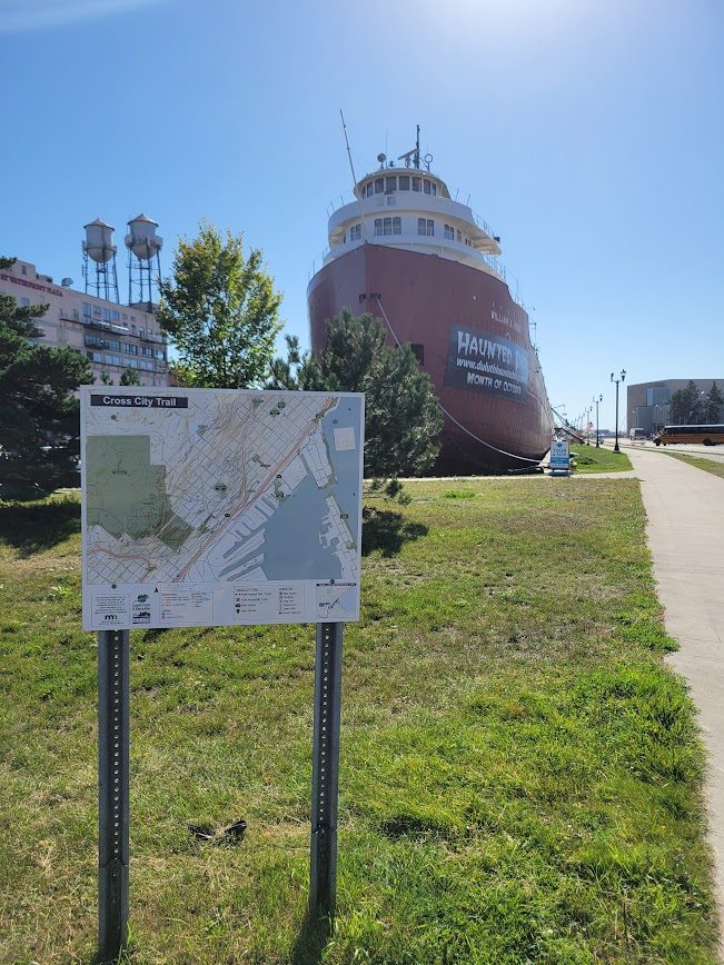
It may have sneaked past you, but Duluth has quietly been adding trails and bike infrastructure. Duluth seems like an imposing place to bike: It is often colder than the Twin Cities, certainly hillier and smaller in population (there’s safety — and acceptance — in numbers). And Duluth is doing a great job of it: In the works are both a visionary redesign of Superior Street as well as the cross-city trail, which will soon connect the Munger Trail to the Duluth Lakewalk, creating a continuous, relatively direct trail route from Brighton Beach to the southwestern border of the city, which is Jay Cooke State Park. The City of Duluth is 26 miles long, and will soon have a mixed-use trail running the entire length. To create a loop with Superior, you just need to connect the existing Bong Bridge path with the Cross City Trail and connect that to the future Blatnik Bridge Trail; then you can slap on some signage and call it done.
Superior, Wisconsin, is smaller than the zenith city across the way, but in 2020, the city approved an active transportation plan that calls for a separated bikeway along Hammond Avenue and Winter Street, which would effectively connect the new Blatnik Bridge to the Bong Bridge path, with Superior’s downtown along Tower Avenue.
If both Duluth and Superior follow through on their plans, which are not in themselves unrealistic, and when MnDOT delivers a bridge with a path, there’s a real chance for this to happen. Perhaps it could even be complete by the time the Blatnik Bridge replacement is done, potentially by 2032. The next part will cover why they should.
Duluth is more than Canal Park, and Superior is not just a lake.
The route I’ve described is roughly 10 miles long and connects some of the Twin Ports’ existing commercial districts, park features and unique architecture. It includes iconic businesses, landmarks and natural beauty that might get passed up by the folks who do the straight shot up Interstate 35 and Highway 61, but are appreciated by people of the Twin Ports and the people who love the Untold Delights of Duluth (and Superior).

Starting from the north end of the Blatnik Bridge, the trail will travel along the “Lake Side” of the bridge, to use the common Twin Ports parlance. The current high bridge is a spectacle to drive along, if you can put the structural woes out of mind, and I’m sure the rebuilt bridge will be just as impressive. The Blatnik Bridge is built to provide clearance to vessels in the shipping channel below, without the bells, whistles and 24-hour operating staff of Duluth’s most famous bridge: the Aerial Lift Bridge. That means it rises 120 feet above the water — which puts you nearly at the height of the grain elevators that dominate the skyline of Superior.
Below, the northern spans of the old Interstate Bridge have been preserved outside the shipping channel as a fishing pier and a monument to the past connections of these twin port towns. From the lake side, you’ll receive all the drawbacks of being on the lake side: often bitter winds, carrying unpredictable weather, any time of year. But you’ll also have a view: over the harbor basin, the impossibly narrow spit of sand that is Park Point, with Lake Superior in the distance.

Rolling down grade into Superior, you’ll navigate the roundabouts that the Wisconsin Department of Transportation (WisDOT) plans to use to replace the current entrance ramp setups, and onto the separated bike lane the City of Superior could have installed on Hammond Avenue. Hammond Avenue takes you by the Hammond Inn, the Rosewood Apartments of the Superior Housing Authority and Dan’s Feed Bin, before delivering you to the separated facility that runs perpendicular along Winter Street. That road sends you by Thirsty Pagan Brewing, an iconic Superior institution that relocated from its repurposed creamery to the repurposed Soo Line train station. Shortly after, you’d cross Tower Avenue, arguably Superior’s main street but definitely it’s most charming commercial street.

Bike lanes currently run along Tower Avenue, giving folks a chance to appreciate Superior’s underappreciated charms — from the Anchor to the Globe News. Winter Street continues through an industrial area of Superior, meeting with the trail for the Bong Bridge north of the Billings Park neighborhood of Superior.

The Bong Bridge is the longest bridge in Minnesota, at a full length of more than two miles. It is the only bridge between Duluth and Superior that has a path for pedestrians or cyclists.

This path is not great in its current form. It is far too narrow for cyclists to be passing pedestrians or for meeting cyclists or pedestrians head to head. But it is currently the best alternative for traveling outside a vehicle between Duluth and Superior. (The Oliver Bridge will not be mentioned here.) In addition, the Bong Bridge is built on a single set of piers, rather than parallel bridge structures. Therefore, it’s theoretically possible to reallocate a bit of deck space to the shared-use path after the Blatnik Bridge has been replaced in full. In addition, the Wisconsin approaches to the bridge are a series of roundabouts, which control traffic speeds and volume.
The Bong Bridge trail currently drops pedestrians and cyclists off at Michigan Street, which has become a frontage road for I-35. Duluth could connect the path to the Cross City Trail by continuing a trail connection and crossing the interstate at 40th Avenue West, where the trail passes. Otherwise, theoretically, the Cross City Trail passes beneath the Bong Bridge, and the Minnesota Department of Transportation (MnDOT) could find a way to connect them through bridge or underpass in a future capital outlay.

Duluth’s Cross City Trail is largely complete or under construction, but worth describing. Northeast of 40th Avenue West, the trail passes beneath the pair of ore docks, currently operated by Canadian National Railway. Highway traffic along I-35 passes under these docks, but passing under them on a bike feels different; it gives you a chance to appreciate these unique structures that still function for their original use, more than 100 years after their construction during a period that has weathered dramatic changes in the mining, steel and maritime logistics industries. Not to mention the often erratic Duluth weather.

The trail lets you back out onto Michigan Street, which soon takes you through the vibrant and growing Lincoln Park business district — home to new Duluth favorites like Bent Paddle Brewing and OMC Smokehouse, as well as classic institutions such as Curly’s Bar. Along West Superior Street (which will have a bikeway accessed by and parallel to the Cross City Trail), the City of Duluth is implementing a visionary redesign of Superior Street that incorporates sensible traffic speeds, a two-way bikeway, recently built transit stops for the Duluth Transit Authority’s “Go Lines” and a top-notch pedestrian environment. Along either Superior Street or Michigan Street, the bike route would connect with Garfield Avenue, through Duluth’s industrial Rice Point neighborhood, which would complete the loop to the new Blatnik Bridge.

Crucially, from the intersection of Garfield Avenue and Superior Street, one would also have the option to follow the existing trail, which splits off to both Downtown Duluth and the Canal Park tourist district as well as the popular Lakewalk. On the flip side, tourists staying in Canal Park or the downtown hotels could use the trail — as well as existing bike rental services — to access a much wider collection of destinations: the Interstate Bridge fishing pier, the World of Accordions Museum in Superior, the businesses along Tower Avenue in Superior.

This loop would connect the growing business district of Lincoln Park with the less appreciated destinations in Superior. It would serve to strengthen active transportation as a way to get around Duluth and the Twin Ports, which holds a lot of potential, comparing the crowded sidewalks of Canal Park in Duluth with the less crowded “Main Street” along Tower Avenue.
Now, I’m not suggesting they’ll become Times Square (thank goodness for that), but good trails are popular in Minnesota. The Gateway and Brown’s Creek trails in St. Paul and Stillwater, the Cannon Valley Trail between Cannon Falls and Red Wing, and the Root River Trails around Lanesboro are all incredibly popular in peak season, and those trails are neither loops nor anchored by a tourist industry as high-volume as Duluth’s Canal Park hotels and DECC (Duluth Entertainment Convention Center) area attractions.
What would be next?
I’ve described here a collection of trails that are planned, under construction or already built. What would I advocate for, except the passage of time and commitment to the blueprint?
Largely, I want to highlight the opportunity that exists, and how with a bit of effort and collaboration, the Twin Ports could craft a recreational and active transportation amenity out of existing projects. This is why I used the “Grand Round” as a framing device. Minneapolis and St. Paul both receive national attention and a lot of acclaim for their parks, with the Grand Rounds as oft-mentioned centerpieces. However, both cities’ Grand Round(s) have gaps in safe infrastructure that won’t be filled for a generation. But Minneapolis and St. Paul lean into the branding, and get away with it. Duluth and Superior don’t need to rely on branding tricks to make a circle.
That said, a little branding would go a long way. The route I’ve identified is roughly 10 miles — a great length to cover between the Twin Ports and appeal to a wide range of people using trails. It’s neither too long nor too short. Admittedly, the long highway bridges have some drawbacks as purely recreational infrastructure. But by highlighting the opportunities on each side of the bridge, and the inherent interconnectedness of the Twin Ports, civic boosters can emphasize that there is someplace to go once you reach the other side — a clear route to lead you back to where you started.
This doesn’t have to cost much in dollars and cents. A few “trailheads,” maps and signage to complement, and perhaps interpretive resources to explain the natural and human history of the communities on St. Louis Bay will provide folks a novel path to follow. And while Duluth and Superior have long shared the same port governance (and transit system), sharing a loop across the St. Louis River offers an unconventional opportunity to lessen the mental barrier a high bridge can pose.
Furthermore, this loop would provide access to trails leading out from the core of the Twin Ports. Crouse, of the of Bicycle and Pedestrian Advisory Committee, explains: “The Blatnik Bridge reconstruction project provides an opportunity to not only address a gap in our regional network but create inter-state connection to the Cross City Trail and Munger Trail on the Minnesota side, and the Osaugie Trail and Tri-County Corridor Trail in Wisconsin.”
A Twin Ports Grand Round has the opportunity to create a piece of transportation and recreation infrastructure that is rooted in the needs and communities of both Duluth and Superior. Connections across the St. Louis River estuary will create opportunities for people to be active, to explore their communities in a new way and to participate in the Twin Ports economy as workers or customers.
I was once in search of all of those opportunities — a college student, working a summer job in Duluth, using my bike to get around, save a buck and experience the natural beauty of the northland and its continuing industrial legacy. I didn’t get to Superior much back then, because the bridge didn’t go there for the modes of travel I was using. In the future, however, it will. And I hope that MnDOT, WisDOT and the Twin Ports of Duluth and Superior are inclined to take advantage of the incredible opportunity in front of them.
All photographs by author unless otherwise noted.