I believe everything has a history worth sharing—especially the roads we think we already know.
I grew up about half an hour from Northfield, close enough that Highway 3 felt less like a destination and more like a given—the road you took to school events, errands, or to get out of town when you needed a little space.
For years, I drove that corridor without really seeing it. Like most people, I experienced Highway 3 as neutral infrastructure—something permanent, inevitable, and mostly invisible. Roads don’t ask to be understood; they ask only to be used. And so I used it, again and again, without questioning why it ran where it did, what it replaced, or who had been asked to make room for it.
It wasn’t until later—after leaving Minnesota and then returning—that the road began to feel less neutral. Passing through Northfield, I noticed how abruptly Highway 3 widens, how it presses against the riverbank, how it divides spaces that feel like they should belong together. The familiarity remained, but it was joined by a sense that something had been interrupted.
Minnesota’s interstates dominate transportation history, but roads like Highway 3 tell a quieter—and in many ways more consequential—story. In Northfield, this legacy highway reveals how early planning decisions, mid-century modernization, and economic pressure reshaped daily life in ways that continue.
Deep Roots: From River to Road
Long before the concrete of Highway 3 was poured, this corridor followed the Cannon River. To the Wahpekute band of the Dakota, the river was known as In-Yan Bo-Sda-Ta Wa-Kpa, or “The Standing Rock River,” named for a white sandstone formation near present-day Castle Rock. The river served as both a physical guide and a cultural artery, shaping patterns of travel, trade, and settlement long before European arrival.
The modern name “Cannon River” is itself a product of linguistic drift. Explorer Joseph N. Nicollet recorded the French name La Rivière aux Canots—the River of Canoes—so named for the numerous Indigenous vessels he observed along its banks. Over time, “Canots” became “Cannon,” and a descriptive name rooted in daily life hardened into a fixed geographic label. The highway that later followed this path became the modern iteration of the same north–south transit need for movement.
The Jefferson Highway and the “Babcock Plan”
The road we recognize today emerged from a much grander continental ambition: the Jefferson Highway. Established in 1915 as a north–south counterpoint to the east–west Lincoln Highway, the Jefferson Highway was an international “auto trail” stretching roughly 2,300 miles from Winnipeg to New Orleans. Promoted by boosters of the Good Roads Movement, it promised motorists a continuous route “from the Pines to the Palms,” linking rural towns to distant cities through a shared vision of progress and mobility.
The highway’s legal permanence was solidified by the “Babcock Plan.” In 1920, a constitutional amendment established Minnesota’s first 70 trunk highways. The path through Northfield was designated as Constitutional Route 1, a status that gave the route a level of permanence and political protection uncommon among local roads. By designating the path through Northfield as Constitutional Route 1, Minnesota lawmakers effectively insulated the route from midcentury bypass logic—a protection that reshaped the town’s economic survival.
Building the Connection
The physical and legal identity of Highway 3 shifted as Minnesota moved from the grassroots enthusiasm of the Good Roads era into the bureaucratic precision of the trunk highway system. The Good Roads Movement itself began in the late nineteenth century, sparked by the League of American Wheelmen, who sought smoother surfaces for bicycles. With the rise of automobiles, the movement expanded into a powerful coalition of farmers, postal workers, and early motorists who argued that rutted, muddy roads imposed a “mud tax” on rural life.
In Rice County, that “mud tax” was tangible. Unpaved roads became impassable during spring thaws, isolating farms from markets and towns from one another. The designation of Constitutional Route 1 transformed a local liability into a state-protected asset.
1920–1921: The Era of Connection
The highway began its life as Constitutional Route 1, a centerpiece of the 1920 Babcock Plan. Local accounts note that at the time, Northfield saw the road as a victory for connectivity rather than a disruption. Construction was a massive local employer, with 40 workers clearing the path and laying the framework for an 18-foot-wide concrete ribbon.
The move toward a paved highway was driven by a desperate need to “eliminate the mud tax,” as noted on a local plaque. Before the 1920 Babcock Plan, the route was often a series of rutted trails that became impassable during the spring thaw, effectively isolating Northfield from its neighbors. The transition to a “Constitutional Route” meant that the path was a state-protected asset. When the 18-foot-wide concrete ribbon was finally laid by 40 local workers, it marked the first time that a resident could reliably plan a trip to Faribault or the Twin Cities regardless of the weather.
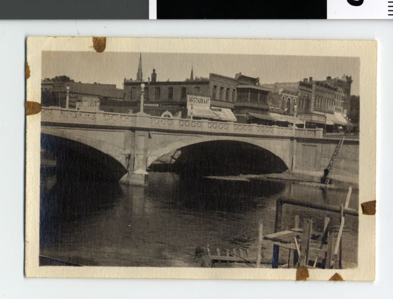
This era culminated on July 21, 1921, with a grand opening that reflected the era’s optimism. An automobile procession led by the American Legion Band traveled south to meet a similar group from Faribault. They met at the halfway point for a public picnic, celebrating the end of the “mud tax” and the beginning of reliable regional travel. To ensure safety in this new motorized age, the city commissioned the North Water Street viaduct in 1921. This critical grade-separation project eliminated dangerous railroad crossings, and the structure remains a foundational—if often overlooked—part of the downtown transit landscape today.
1934–1957: The Transitional Years
As the state refined its numbering system, the road was redesignated as MN-218 in 1934. For two decades, it served as a primary north-south link, but as post-war car culture exploded, the original 18-foot width became a bottleneck during the post-war car boom. The “integrated city street” model began to clash with the state’s desire for higher throughput.
1958: The Great Severance
Records indicate that the most traumatic shift occurred in 1958 during a major “modernization” project. This was the moment Highway 3 stopped being a main street and became a boundary.
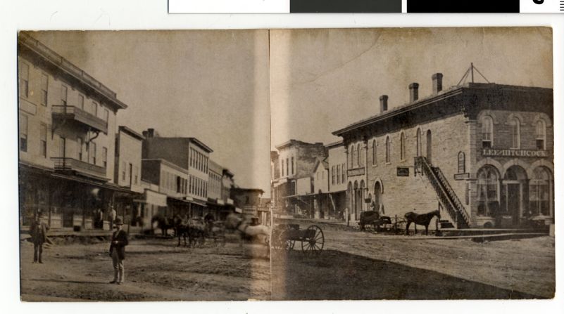
Maps, plats, and municipal records from the era show a dense mix of homes, storefronts, and service buildings where the widened roadway now stands. To transform the road into a high-capacity corridor, documents show that 17 buildings were razed on the west side of the river. This functionally severed the historic “West Side” business district from the core of downtown. The casualties included:
- Commercial Storefronts: These were part of what locals called the “Q Block” (named for the iconic Quarterback Club, which survived but was isolated).
- Residential Homes: Several older frame houses that lined the original, narrower Water Street.
- Small Industrial/Auto Shops: Given the era, these were typical “highway-adjacent” service buildings that were no longer deemed “compatible” with a wider, faster state trunk highway.
The 1958 expansion was more than a civil engineering project; it was a reordering of the city’s social geography.
Northfield’s experience was not unique. Across Minnesota, modernization projects of the mid-century traded local access for regional speed. This shift reflected a broader mid-century belief that speed and efficiency mattered more than local continuity. In Northfield, however, the loss was spatially precise: the historic West Side was transformed from a neighborhood into a corridor.
1963–1992: The Modern Highway 3
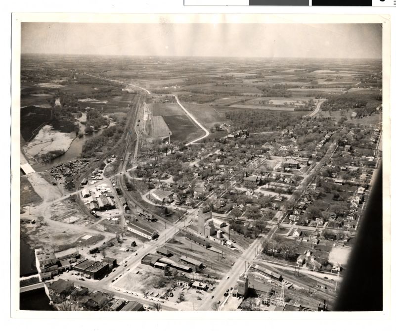
It wasn’t until 1963 that the road finally received its current name: Minnesota Highway 3. It was shortened to its current mileage, running from Faribault to St. Paul. By 1992, the road was further resectioned into the three distinct segments we recognize today: the northern bridge approach, the southern intersection with Highway 19, and the central transit segment through the heart of Northfield.
The evolution of the road’s nomenclature—from the Jefferson Highway to MN-218 and finally to Highway 3—mirrors the professionalization of American travel. By the time the road was resectioned in 1992, it had completed its transformation from a romantic international trail into a precise transit tool. Yet, even as the legal designations grew more clinical, the road maintained its sensory character, anchored by the 1856 Ames Mill and the aroma of the cereal production that has defined the Northfield air since 1927.
Malt-O-Meal and Ames Mill
For any traveler, the first indication that you are nearing Northfield isn’t a sign—it’s the smell. The air becomes sweet, warm, and all-encompassing: the scent of Malt-O-Meal.
While the factory is not directly on the highway, the Ames Mill anchors the view. Originally built in 1856 by Northfield founder John W. North, it was sold to Captain Jesse Ames in 1865. This “concrete giant” was more than an employer; it was a pioneer of the “middlings purifier” process. This technology created an extraordinarily pure white flour that, at the 1876 Centennial Exposition in Philadelphia, was officially named the best “straight flour” in the United States.
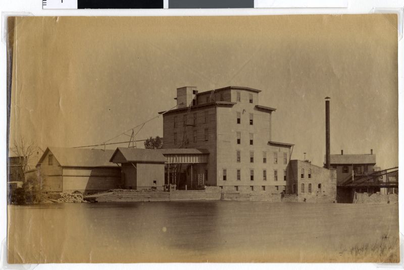
Its transformation into a sensory landmark began in 1927 when John S. Campbell moved his Campbell Cereal Company to Northfield—local lore claims he used an $800 poker-winning investment to do so—to mass-produce “Malt-O-Meal.” The mill’s transition from flour to cereal in 1927 saved it from the decline that shuttered other Midwestern mills.
Campbell moved his operations from Owatonna to the Ames Mill because of the facility’s superior water power and railroad access. The mill quickly became a local icon, once featuring a giant neon sign that flashed “MALT-O-MEAL” so brightly it could be seen as far away as Dundas. Today, while the company has grown into a billion-dollar subsidiary of Post Consumer Brands, the Ames Mill remains a “utilitarian treasure,” continuing to produce the cereal that has scented the Highway 3 corridor for nearly a century.
Economic Dissonance: The Double-Edged Sword
Highway 3 creates a familiar tug-of-war in Midwestern towns. It delivers the convenience and efficiency of big-box stores while also serving as the artery that brings visitors to locally owned shops and historic downtowns. As online shopping grows and property taxes rise, Northfield’s economic future depends on the highway’s ability to function as a gateway rather than a bypass.
That tension is not abstract; it is felt most clearly in the everyday movements the highway enables—and in the spaces people choose to stop rather than pass through.
For example, I discovered Goodbye Blue Monday on a lazy Saturday, driving my Intrepid with Dashboard Confessional blasting, looking for a place to disappear into a book. In that way, Highway 3 functioned exactly as it had for earlier generations—farmers escaping the “mud tax,” workers commuting to the mill, teenagers testing the edges of who they might become. Much like the road itself, the coffee shop became a sanctuary between past and future, between my two home states of Minnesota and Kentucky.
In this way, Highway 3 has functioned not only as an economic corridor, but as an uneven distributor of access—offering mobility, anonymity, and choice to some, while earlier versions of the same road removed those possibilities from others.
The Road to Freedom
Personally, Highway 3 was the road that carried me toward a sense of freedom in the early 2000s. I didn’t get my driver’s license until I was seventeen, and growing up in a small town with little anonymity, driving felt like permission—to be unseen, to be elsewhere, to imagine a life that wasn’t already mapped out for me.
At the time, I understood that freedom only in personal terms. The road gave me distance from expectations, from familiarity, from being known before I could define myself. What I did not yet understand was that this same corridor had offered very different experiences of mobility to others—and that earlier versions of the road had taken that freedom away as often as they had delivered it.
Highway 3 has always promised connection. It once followed the river’s logic, then the optimism of early automobile travel, and later the efficiency demands of mid-century modernization. But each version of the road also imposed limits: on neighborhoods, on access, on who could safely cross, linger, or belong. What felt liberating to one generation arrived as rupture for another.
Today, when I drive through Northfield, the road feels layered. I smell the cereal drifting from the Ames Mill. I see the widened lanes pressing close to the river. I notice how easily I can pass through without stopping—and how much effort it takes to move across rather than along it. The freedom the road once gave me now feels inseparable from the question of what it cost.
When you drive Highway 3, you aren’t just commuting; you are traveling a “storied thoroughfare.” It is a vital link in our state’s history, and it remains the promise of a new adventure just thirty minutes down the road.
This article draws on publicly available historical records, state transportation documents, and local archival sources rather than new interviews.
This publication was made possible in part by the people of Minnesota through a grant funded by an appropriation to the Minnesota Historical Society from the Minnesota Arts and Cultural Heritage Fund. Any views, findings, opinions, conclusions, or recommendations expressed in this publication are those of the authors and do not necessarily represent those of the State of Minnesota, the Minnesota Historical Society, or the Minnesota Historic Resources Advisory Committee.