Img 7783

Winding My Way Down On Baker Street

August 4, 2019

17.3 Miles

Macalester-Groveland, West Seventh, West Side

Explored the West Side on this ride. It’s a place I’ve been many times to eat, drink and celebrate Cinco de Mayo, but sporadically on my bike. Therefore I’m familiar with many of the main roads on the West Side – Concord Street, Cesar Chavez Street, Smith Avenue, and of course Robert Street (with which I’m so well acquainted that I call it Bob Street.) But the bulk of the West Side is new to me and stocked with discoveries.

It takes some pedaling, and a stop or two, to get to the West Side from my house. One pause of note was on Benhill Street, a Mac-Groveland thoroughfare that curves down among the bluffs and has gorgeous and large old homes.

An ode to A.A. Milne in the form of a intricate tree carving greets all who pass 15 Benhill Street.
The detail of the carving almost brings Pooh alive.

There is no way to get to Cherokee Heights or anywhere else on the West Side without earning it through a climb up at least one street that scales the steep bluffs. My route of choice was the new High Bridge, which reopened in late November 2018 after a complete renovation that shuttered the bridge for 15 months. The marvelous view of the Mississippi and surrounding areas remains. Among the multitude of improvements is the new bike/pedestrian lanes which are separated from motor vehicle traffic by a concrete wall. (I don’t have pictures of the view or the bike/pedestrian lanes because I chose to ride the entire length of the High Bridge rather than stopping for photos.)

The western end of Baker Street, where the street curves to the left and becomes Cherokee Heights Boulevard.

Baker Street runs nearly the entire east-west span of the West Side, save for a couple of short interruptions.

The homes on the western blocks of Baker Street range in age from 80 to 110 years old.
Moving east, the homes are far newer. For example, in this block, 175 to 205 West Baker, most of the houses are modest, single story homes built in the late 50s and early 60s.
The original Baker Community Recreation Center building at 670 Waseca Street, now known as the annex.

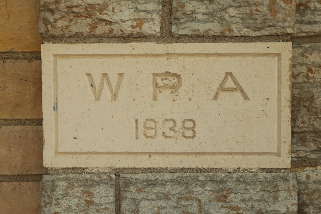
As I continued east on Baker Street, a large athletic field came into view as I crossed Waseca Street. I doubled back to Waseca Street and turned south to investigate. Just a block south I found the unassuming but well cared for Baker Community Recreation Center building. The white and cream stone building, a WPA construction, was built in 1938, the most prolific year for WPA projects in Minnesota.

I presume that the excellent condition of the 80 year old building’s exterior is due to a recent renovation.
The cornerstone of the Baker Rec Center Annex.

Around the back, there was action in the form of people organizing uniform pieces into bins.

Marissa Franco looks through a bin of football equipment.

Marissa Franco, her brother, Carlo, and another person were hard at work sorting through sundry pieces of football equipment. Marissa told me they were getting ready for the West Side Boosters’ football season. “They are a community organization nonprofit that serves the kids here on the West Side, and not just sports but life and teaching these kids how to be adults and teaching them good skills to have.”

Marissa and Carlo Franco use bins to sort different sizes of football pants and jerseys.

The West Side Boosters was founded in 1970 but according to its website, its roots go back another 30 years.

About 300 kids in fourth through eighth grade signed up to play tackle football in 2019, said Marissa, and about 30 pre-kindergarten through third graders registered for flag football. And yes, she stated emphatically, some girls play too.

“We have some girls out here. Could we get the few girls who are tough enough to get out here and play football? Oh, yeah!”

Marissa talked about the pride West Siders have in the youth teams. “There’s a lot of people in this community who are so involved and everybody takes such big pride in being a West Side Booster. The traveling basketball team that goes around the United States to play and when people see it they recognize that those are the West Side Boosters from the West Side of Saint Paul.”

Marissa sorts football pants by size.

The West Side Boosters is a long-standing tradition for Marissa’s family. “My dad played for the Boosters when he was a kid. And so all his friends are now coaching. They coach or they have kids and grandkids that play for the Boosters.”

“My dad was the Booster president way back in the day when I played for the Boosters and my brother played for the Boosters and our younger sisters also played for the Boosters as well.”

Marissa’s sports of choice were hoops and softball with the West Side Boosters. “Basketball from kindergarten through eighth grade. I played t-ball and then I went into softball and played that from kindergarten through 8th grade.”

“We take pride in our kids making sure that they grow up and they know that they always have somewhere to come back to. We always say once a Booster always a Booster.”

One of several West Side Booster signs I spotted in yards on my ride.

Marissa is proudly immersed on the West Side, from the Boosters to her job. “I work at Humboldt as a special ed paraprofessional. I’ve worked with every setting in that building from deaf/hard-of-hearing to emotional behavior kids, autistic development, developmentally challenged students, and then just in the general public at Humboldt. A lot of the kids already know my face so they know that there’s somebody there that was here. I went to Humboldt. I did the stuff. I was you guys at one point.”

“We’ve had multiple City championships. People ask, ‘Who do you guys play for? You guys play hard,’ and it’s always fun to say, ‘Oh I played for the West Side.’”

“If people didn’t give back then we wouldn’t have this big of a program. All of our coaches played in the Boosters when they were kids. All of our former players come back to watch games. It’s a family thing.”

From the athletic fields to the east the true size of the Baker Annex became apparent.

The “new” Baker Rec Center is at 209 Page Street West but it’s no more than 50 yards to the south and up a hill from the Annex.

The main entrance to the Baker Rec Center.
A new playground and picnic tables were quiet on this warm afternoon.
The back of Baker Center faces the Annex.

The nonprofit Youth Farm has one of its five Saint Paul gardens at Baker (and five others in Minneapolis.) The Youth Farm mission, according to its website, is to grow food, community and leaders. Its programs are open to young people from ages 9 to 24.

The Cherokee Heights and Youth Farm Garden and greenhouse are on the Baker Center property.
Baker Rec Center is attached to Cherokee Heights Elementary School.
Cherokee Heights opened to students in 1925, although it was called Bryant School then. The three story structure behind the entrance is the original 1925 building.
Cherokee Heights opened to students in 1925, although it was called Bryant School then. The three story structure behind the entrance is the original 1925 building. Cherokee Heights is named for the neighborhood in which it is located.
The building was expanded twice, in 1971 and again in 2000. You can see both additions in this picture.
Vivid “barn quilts” decorate the fencing that surrounds gardens in the front of the school.
A combination of physics and art, the exceptional rock wall and fence at 649 Winslow feature so much to love.
A combination of physics and art, the exceptional rock wall and fence at 649 Winslow features so much to love.

Upon completing the tour of Baker Rec Center and Cherokee Heights Elementary School it was back to Baker Street to continue eastward. Six blocks later, at Humboldt Avenue, sprouted a large, multi-block, school complex.

I counted at least five separate additions in this view.

My keen sense of the obvious told me this must be the Humboldt High/Junior High School complex at Baker Street and Humboldt Avenue. I’d been to the Humboldt complex previously but hadn’t ever approached from the west, and the Open World Learning Community (OWL) sign added to my confusion. With a bit of research I learned that OWL is a 6th through 12th grade program with about 450 students within the complex. Humboldt, meanwhile, also has 6th through 12th grades within another part of the building.

The red brick building to the center-left is the 1909 Humboldt building.
A close look at the brickwork and one of the decorative elements on Humboldt’s 1909 building.

Humboldt was named in honor of Baron Alexander von Humboldt, a renowned German scientist, explorer and statesman who died in 1859. His work advanced knowledge in geology, meteorology, biology and more. A comprehensive list of von Humboldt’s many accomplishments is on the Humboldt State University website.

This 1909 building was the third Humboldt School constructed by the school district. The original, likely for kindergarten through 8th grade students, opened in 1879 on the southwest corner of Robert Street and Colorado. That site is now occupied by a part of the Torre de San Miguel Homes. Only nine years later the second Humboldt building (and first Humboldt High School) opened about two blocks away on the southeast corner of Livingston and Delos.

Humboldt High School circa 1915. Courtesy Minnesota Historical Society
Humboldt High School circa 1915. This was the third building to house Humboldt students. Courtesy Minnesota Historical Society
Students hard at work in an art classroom in 1918. Courtesy Minnesota Historical Society
The north side of the Humboldt/Open World Learning campus. The 1909 building is on the left. The structure on the right, I believe, is part of a 1976 addition.
The north (Elizabeth Street) side of the Humboldt/Open World Learning campus. The 1909 building is on the left. The structure on the right, I believe, is part of a 1976 addition.
Humboldt’s four acre School Forest was established in 2000, according to school district minutes. The School Forest program, a partnership between the state DNR and participating schools. It was authorized by the Minnesota Legislature in 1949. Other than this sign, I saw no other obvious hint of the forest.
Humboldt’s four acre School Forest was established in 2000, according to school district minutes. The School Forest program, a partnership between the Minnesota DNR and participating schools, was authorized by the state Legislature in 1949. Other than this sign, I saw no other hint of the forest.

The block-long retaining wall along Elizabeth Street on the north side of the Humboldt/OWL complex has been colorfully adorned by school clubs, teams and students with images representing the school and West Side.

Logos of the Humboldt Hawk, the City of Saint Paul, District del Sol, and Junior ROTC adorn the school’s retaining wall.
A representation of the iconic High Bridge.
Names and palm prints of former Humboldt students.
The main entrance to Humboldt Secondary is where I’d entered the building on past visits. It looked slightly different now because of major remodeling.

Continuing my way around Humboldt I reconnected with Baker Street, which is where the main entrance to the building is. This is when I discovered the school complex was under construction.. The magnitude of the renovation fully dawned on me when I turned onto Livingston Avenue. It might seem odd that I didn’t notice major construction until I got to the third side of the building but the Humboldt/OWC campus occupies seven city blocks!

The Humboldt/OWL campus, including athletic facilities and parking, occupies the equivalent of seven city blocks.
The Humboldt/OWL campus, including athletic facilities and parking, occupies the equivalent of seven city blocks. Courtesy Google Maps
Humboldt/OWL is in a residential neighborhood. These homes are across Baker Street (north) of the main entrance.
From Livingston Avenue and Baker, the extent of the remodeling and expansion became apparent.
From Livingston Avenue and Baker, the enormity of the remodeling and expansion became apparent.
Another view of construction of the new wing at Humboldt.
Looking toward the school from the south end zone of Humboldt’s football and soccer field, both a part of the Bob Ryan Athletic Complex.
The scoreboard still has a logo from when Humboldt was known as the Indians. The mascot was changed to Hawks for the 1992-93 school year.

Back on Baker Street near Humboldt’s main entrance, I rode east one block to Robert Street, where Baker ended for two blocks. After a quick jog south on Robert to Morton Street, I took a left. Morton is an extremely short street with just three homes and a former church. The street dead ends for cars but has a pedestrian stairway down to State Street.

One of the three homes on this very short section of Morton Street.
A walk down the stairs takes you to State Street and Morton.
The stark doors on the back and south side of the church were incongruous with the building architecture.

I was intrigued by the petite red brick church on the northeast corner of Morton and Robert which seemed to be well maintained, aside from overgrown bushes and trees.

The front door and one on the north side also seemed to be about security. The silver onion dome still looked gorgeous.
Perhaps the Debregenet Saint Mary Ethiopian Orthodox Tewahdo Church congregation had problems with break-ins or vandalism, necessitating the more secure doors.

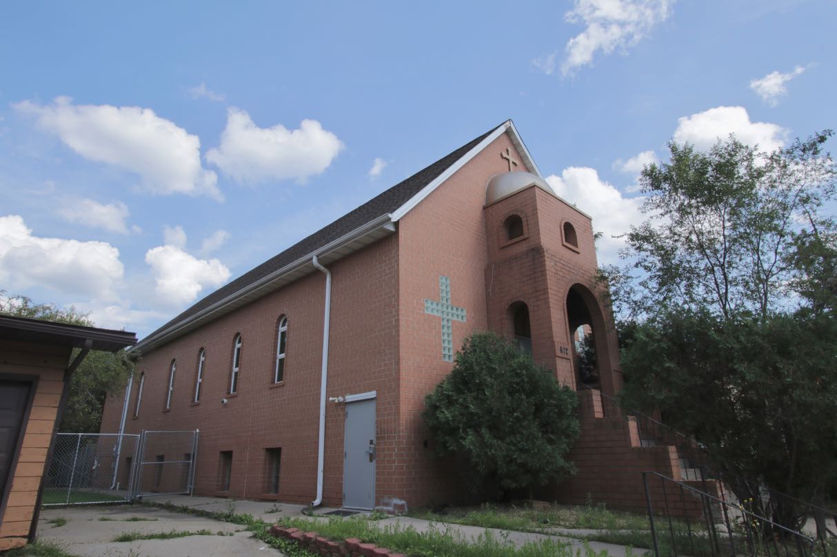
Turns out the Ethiopian Orthodox Tewahado Church is no longer in the building and it and the home to its north are for sale.

At one time the congregation of Saint Mary’s Antiochian Orthodox Church, primarily descendants of Syrian and Lebanese immigrants who came to Saint Paul in the late 1800s, worshiped here. In 1998 Saint Mary’s merged with nearby Saint George Antiochian Orthodox Church and moved to West Saint Paul.

MNHS photo In 1981 the church was known as Saint Mary’s Eastern Orthodox Church and was almost unrecognizable from the building today. Courtesy Minnesota Historical Society
In 1981 the church was known as Saint Mary’s Eastern Orthodox Church and was almost unrecognizable from the building today. Courtesy Minnesota Historical Society
The Baker Street jog at Bidwell.

Morton Street’s dead end seemed like a fine place to turn back toward home, even though I had a few more blocks of Baker Street to travel. Returning west along Baker, I followed its very short jog north at Bidwell Street. Just before turning west back onto Baker, the sight of the First National Bank building in Downtown transfixed me.

The astounding view of the First National Bank building from Baker and Bidwell Streets.
This astounding view of the First National Bank building from Baker and Bidwell Streets doesn’t actually exist. The use of a large zoom lens allowed me to capture this image.

I can’t think of a better way to rap up this ride than seeing the First National Bank building (and a few other Downtown buildings) framed by trees on Bidwell Street.

Click here for a turn-by-turn view of the route I took for this ride.

Wolfie Browender

About Wolfie Browender

Pronouns: He/Him/His

Wolfie Browender has lived in Saint Paul with his wife, Sue, since 1986. His two adult daughters also live in the Capital City, one Downtown and the other on the East Side. Wolfie bikes for fun and exercise. Follow his travels along the more than 800 miles of streets in his quest to ride every block of every street in Saint Paul on his blog Saint Paul By Bike at SaintPaulByBike.com.