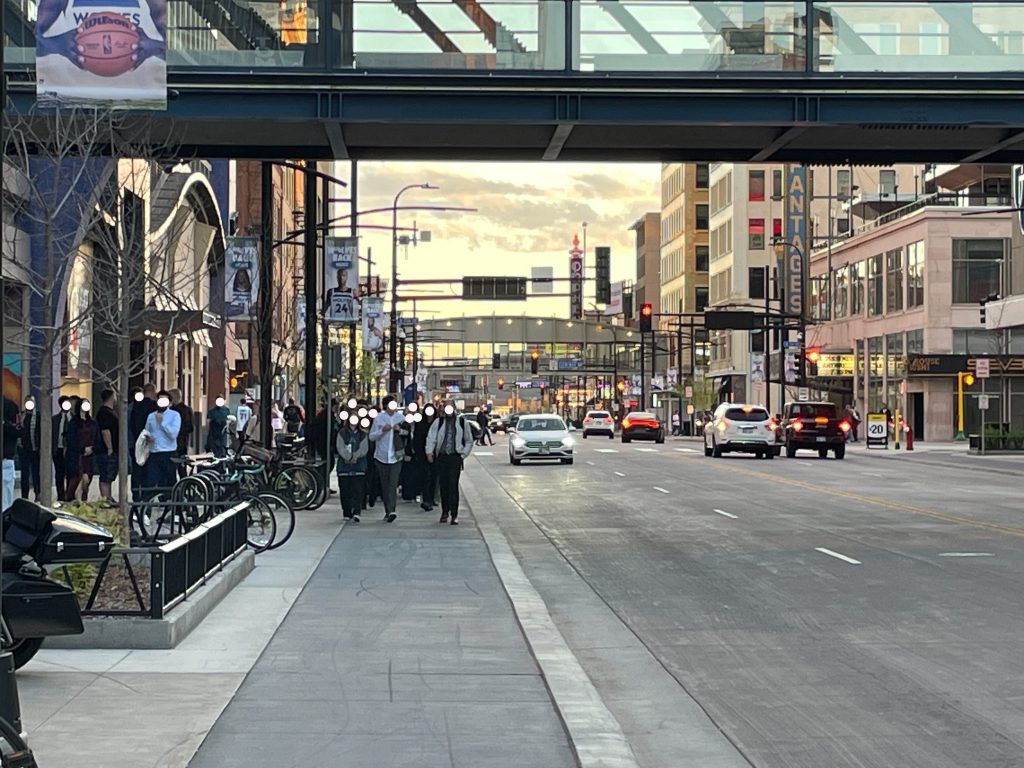
Brian Mitchell writes this as a resident of The Wedge near LynLake, and as a volunteer for Move Minnesota’s Minneapolis volunteer team and the Livable Lyndale campaign. These thoughts are his own and not made on behalf of either group.
On August 14, Hennepin County released their final plan concept for the Lyndale Avenue South reconstruction project (though they are looking for more feedback). This plan was released months late after the comment period closed last fall, following the release of three options for the corridor. This final plan adds a shared-use path to Lyndale Avenue South, which is woefully inadequate for such a highly utilized corridor.
The new concept for Lyndale Avenue South misses an important opportunity to separate the high, medium, and slower speed users of the corridor. I believe that all road users deserve to be safe on streets in Minneapolis, and the separation of sidewalks from bike-ways is part of that. The first part of this article covers the background of the street, followed by some problems with the current design, opportunities, and suggestions. It’s not too late to make your voice heard and change the design!
Background
The section of Lyndale Avenue South from Franklin Avenue to 31st Street is due for reconstruction. This road is owned by Hennepin County and was last constructed in the 1930s. The entire project corridor is classified as a “High Injury Street” and also contains two “High Injury Intersections,” as listed in the Minneapolis Vision Zero action plan. The Vision Zero Crash Study identifies a High Injury Street as one of 9% of streets in the city that have 66% of the fatal crashes from 2017-2021, and a High Injury Intersection as one of the top 26 most high-risk intersections.
On October 12, 2019, Ted Ferrara was hit and killed by a driver on the 2500 block of Lyndale Ave. This sparked outcry, a #FixLyndale demonstration, and pressure to improve safety on the dangerous four-lane street. The County hosted a listening session in 2019 and responded by launching a pilot to re-stripe the street for a four-to-three lane conversion and add medians at 25th and 27th Streets. There was a lot of backlash to this pilot before it was implemented, particularly from business owners. The street was re-striped and medians were added in the summer of 2022, and the following year was touted as a success (from business owners, too!) in improving safety, slowing speeds, and improving pedestrian access. The County reported that crashes decreased by 57% and injury crashes decreased by 48%. Additionally, 83% of people felt more comfortable walking or rolling across Lyndale Avenue and 74% of people felt more comfortable driving on or across Lyndale Avenue.
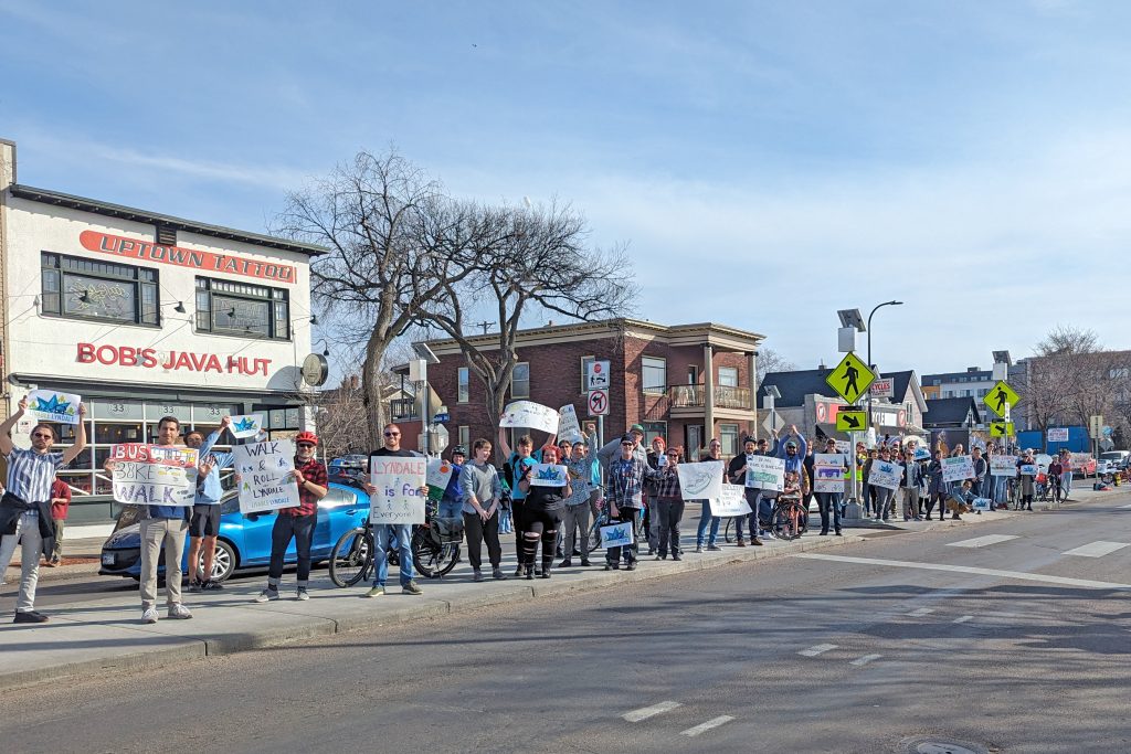
The Move Minnesota Minneapolis volunteer group came together in the fall of 2022 to focus on Lyndale Avenue reconstruction, later launching the Livable Lyndale campaign. The team hosted several rallies and a median party in 2024 and 2025, focusing on pedestrian, cycling, and transit users, to show support for a design that has a dedicated bike path and all-day bus lanes.
Hennepin County hosted an open house at the Jungle Theater on August 24, 2023, asking for feedback and ideas for the corridor. This was followed by another open house on June 11, 2024, at SpringHouse Ministry, collecting feedback on newly released high-level design concepts. During the winter of 2024, they announced a new timeline for the project, delaying construction one year to start in 2027.
On October 24, 2024, the County hosted another open house at SpringHouse Ministry to gather feedback on the newly released three concepts for the street. The Blue option included a two-way bike path, the Purple option included transit lanes on the north end of the corridor, and the Orange option included both a two-way bike path and transit lanes on the north end of the corridor. The difference in available street parking between these three concepts was fairly negligible. Parking on the street is already underutilized, with 63% of parking near Lyndale Avenue South unoccupied (69% off-street and 49% of on-street parking) according to a 2023 Hennepin County study.
From 2023 to today, volunteers with the Livable Lyndale project have collected over 2,400 petition signatures and over 1,425 handwritten postcards. This petition (in addition to signed postcards, collected through various canvassing efforts) aims to show support for dedicated bus and bike lanes. The postcards allow for additional comments and have been delivered to Hennepin County Commissioner Marion Greene. This shows that there is immense public support for improving access and safety for people of all modes on this corridor. People are excited about the idea of faster transit rides through the corridor, and adding a separated bike path for commuting through and accessing businesses along the street.
The Final Plan
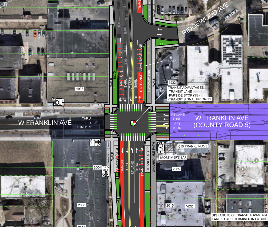
The new proposed layout north of 29th Street includes bumpouts at intersections to reduce crossing distances, concrete medians, and other features commonly found in modern street construction. The plan includes bus lanes north of 24th Street (for northbound traffic) and a small stretch southbound around Franklin Avenue. There’s a new and much-needed protected pedestrian crossing at 29th Street. The plan also closes the bikeway gap between Franklin Avenue and the Loring Greenway with the addition of a two-way bike path from the Wave Bridge to Franklin Avenue.
On August 21st, the County published a post that goes into some detail about the new concept. In there, they highlight four needs and goals they heard from residents and business owners:
- A safer Lyndale Avenue
- Better connections, comfort, and access for everyone
- Greener street for the future that preserves trees
- Meeting current and future community needs
I can see how they ended up with the concept presented given these goals, but believe that it’s a compromise that fails safety, comfort and future community needs.
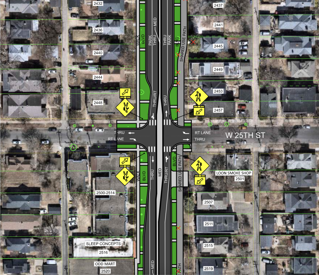
Shared-Use Path
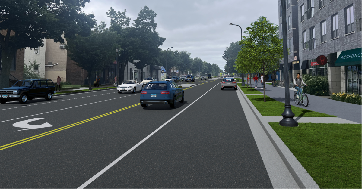
Astonishingly, the plan features a shared-use path on the east side of the corridor from Franklin Avenue to 29th Street. A shared-use path forces all users outside of motor vehicles into one space: people walking, rolling, biking, using scooters, people using cargo bikes and trailers, strollers, and more. A shared-use path is a great option for lower-density environments and quiet streets, but Lyndale Avenue is a dense corridor filled with businesses in one of the most walkable and bikeable areas of the state. The upcoming plan for the Franklin Avenue reconstruction (a county road) sets the standard for prioritizing separated facilities except where there’s limited space for two blocks near I-35W. If Lyndale Avenue is constrained in some places, that would be the time for a shared-use path, not the entire length of such a pedestrian-heavy corridor.
The City of Minneapolis Street Design Guide explicitly says that “Shared use paths are not appropriate for streets with high pedestrian and bicycle volumes.” It states that limited space could make dedicated bike and pedestrian paths “impossible or impractical,” but the County has already shown that there is plenty of space for both, and a bus lane, as outlined in the previously released Orange option.

To get an idea of the experience, the bike paths on Hennepin Avenue in downtown Minneapolis are separated from the sidewalk (but at the same curb level) by planters, buffers, and rumble strips, and are differentiated from pedestrian walkways by pavement color. Even with all of that, pedestrians frequently walk into those bike paths (unknowingly or not) and cause conflict for use of the space. What is proposed for Lyndale Avenue is far worse.
This shared-use path would likely be 12’ wide (the designs are missing any fixed measurements), and no amount of markings or signage telling people to share the path will truly communicate that a scooter is coming up quickly behind you when walking, nor will it ease the frustration of ringing your bike bell at pedestrians trying to announce your presence. Pedestrians rightfully feel safe on most sidewalks in the city, and aren’t used to sharing it with medium speed users. With more space, people will feel comfortable walking two or three abreast, which isn’t wrong, but makes for conflict with other users of the path.
In canvasing for Livable Lyndale, we heard that people want to be able to bike to destinations on the corridor. Hennepin County proposing a shared-use path over just a sidewalk supports this. However, the shared-use path effectively keeps cyclists using Bryant Avenue for “commuting,” with the shared-use path on Lyndale Avenue only for local access. I see several problems with this:
- Bryant Avenue South between Lake Street and Franklin Avenue has no bike facilities on the street. There are five stop signs to cross Franklin Avenue from Lake Street (and the Midtown Greenway), conflict with motor vehicles, and poor maintenance in the winter, which makes commuting slower.
- Drivers of motor vehicles get to use Lyndale Avenue for both commuting and accessing businesses, why can’t bicyclists?
- This dismisses the needs of residents of Whittier, who need to cross Lyndale Avenue to commute north on Bryant Avenue, only to cross back on the Wave Bridge to continue north towards downtown.
Throughout the volunteering efforts of the Liveable Lyndale team, project staff and Marion Greene made it clear that safety for non-drivers was important and that the risk of bike collisions with other users (walkers, rollers, etc.) was of utmost importance. Given these concerns, it does not make sense that all of these users are forced together in the same space where previous options (Blue and Orange) made separations between cyclists and other pedestrians. Ultimately, I believe that all road users deserve to be safe on streets in Minneapolis, and the separation of sidewalks from bike-ways is part of that.
Missing Potential
There are other issues with this plan, such as removing the shared-use path at 29th Street and not marking that new crossing with green paint for bikes. This cuts off access to businesses at Lake Street (the heart of LynLake) and to 31st Street (a Long-term Low Stress Bikeway in the All Ages and Abilities Network of the Minneapolis Transportation Action Plan). I’m worried that this new plan will make the LynLake intersection more dangerous for people on bikes. After the four-to-three-lane conversion in 2022, there are painted buffers on the street, which I have personally seen many people ride over to get to and from businesses. LynLake is the primary destination of the corridor, and it’s dangerous that there’s no bike connection to that.

South of the Midtown Greenway, the county is largely only doing a mill and overlay, without moving curbs much or re-grading the entire street. Given that, there is space to convert the east side of the street to be a two-way bike path with a concrete curb down at the street level, especially if the mid-block turn lane is removed and replaced with a concrete median. This is a compromise that would show dedication for safe access to LynLake and encourage a mode shift for the area.
The County has worked with MetroTransit, and like in the past, the dedicated bus lanes are northbound north from 24th Street, and southbound to Franklin Avenue. In talking with project staff, they communicated that MetroTransit says the largest need for bus lanes is in that area. Adding extra wide parking lanes with a potential for full future bus lanes seems a little unnecessary, and comes at a cost. Activating those lanes in the future would require removing bumpouts and curbs that add protections for pedestrians at intersections. With more space, drivers of motor vehicles will feel more comfortable driving faster, which reduces safety on the corridor. These extra wide lanes also take valuable space that could otherwise be spent on a separated bike path. Using features like transit signal priority, bus queue jumps, and limited additional bus lanes where needed, transit can be improved on the corridor and still allow for enough space to include a separated two-way bike path.
It’s not too late for the plan to change. I urge you to go to the Lyndale Avenue plan comment map and leave comments on the plan, and to write to project staff and elected officials. Let your Hennepin County Commissioner and your Minneapolis City Council member (who needs to vote on municipal consent to the layout) know that a shared-use path is not good enough; we need a separated two-way bike path like in the Orange option, shown to fit in the corridor by the County from last fall.
Hennepin County is hosting an open house to see the designs, talk to project staff, and give feedback. Please come to share your thoughts!
Wednesday September 10, 2025
4 to 6 PM
SpringHouse Ministry Center
610 West 28th Street
Minneapolis, MN 55408