
Freeway development in the Twin Cities, while considered necessary for economic growth and to address traffic congestion, was not particularly kind to the neighborhoods it went through. Where it didn’t destroy neighborhoods entirely, it seriously impacted them. Once construction was complete, the neighborhoods had to contend with the noise and pollution from vehicles using the freeway. The remaining neighborhoods along the freeways were also cut off from each other due to the limited number of bridges across the freeways. The wide expanse of the Minneapolis freeways, often a full block wide, further contributed to this “neighborhood gap”.
A recent post by David Levinson inspired me to take a look at one of these neighborhood gaps. Built in the early 1970s on the east side of downtown Minneapolis, I-35W creates a gap between Downtown East and the Cedar-Riverside neighborhood. The 3rd St/4th St trench, built at the same time as I-35W to facilitate traffic from I-35W and downtown to the University of Minnesota campus, further complicates local connectivity, resulting in Washington Ave being the only local connection between Cedar-Riverside and downtown.

Northbound I-35W at the 3rd St/4th St trench. Photo by the author.
Other ideas have looked at the same area, with the idea of reconfiguring ramps or restoring the street grid. A class presentation from a group of U of M students several years ago suggested building a land bridge over I-35W and the trench with the idea of putting the new Twins stadium there. The Downtown Action Plan portion of Access Minneapolis supports changes to the interchange area. My proposal utilizes several of these ideas (sans new Twins stadium, of course) plus a few more.
The author’s proposal to bridge the neighborhood gap between Downtown East and Cedar-Riverside.
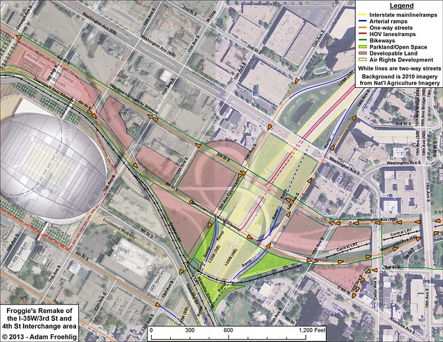
By far, the biggest change I propose is filling in the freeway trench and restoring 3rd St and 4th St to the original street grid, which provides several benefits. In conjunction with reconfiguration of the I-35W ramps, it retains all existing access, including direct access across the river to the U of M East Bank. It provides an alternative to the busy Washington Ave for both I-35W traffic and local traffic, and re-creates a direct connection between Downtown East, Seven Corners, and Cedar-Riverside. Provisions can be made for cycletracks along both 3rd and 4th between Chicago Ave and Cedar Ave with connections to both the Hiawatha LRT bikeway and the U of M West Bank.
The I-35W interchange is reconfigured from its current tangle of ramps into a split diamond interchange, serving Washington Ave, 3rd St, and 4th St with full access. To accommodate heavy traffic volumes from downtown, a direct ramp from 4th St to northbound I-35W is included. A reciprocal ramp from southbound I-35W to 3rd St is not included but could easily be added if traffic conditions warrant, although this slightly reduces the amount of land available for air-rights development. Also included are direct median ramps to 3rd St and 4th St for HOVs and buses. These HOV ramps could tie into potential MnPASS lanes on I-35W North, which in turn could potentially connect to the Northeast Diagonal corridor into Ramsey County.
As part of the trench filling, 15th Ave can be restored between Washington Ave and 4th St, as proposed in the transportation section of the Cedar-Riverside Small Area Plan. As part of the I-35W interchange reconfiguration, 13th Ave is restored as a one-way connector between 2nd St and 5th St, with 14th Ave restored between 4th St and 2nd St. These changes restore city blocks that can then be developed with shops, residencies, or parkland.
While not insurmountable, a few engineering challenges exist with this proposal. Filling in the freeway trench will be a major endeavor involving a lot of earth moving and replacing the bridges on I-35W over the freeway trench. Reconfiguring the I-35W interchange and adding the street grid will involve a lot of construction and require ramp closures. The grade of the Central LRT line necessitates moving a potential 4th St/15th Ave intersection slightly north and bridging it over the LRT tracks (not unlike another 4th St/15th Ave intersection in nearby Dinkytown).
To the west, there isn’t enough distance to retain the existing 4th St underpasses at 11th Ave and the LRT tracks and still bring 4th St on top of I-35W. The resulting grade would be too steep. To accommodate this, I have swapped 4th St and the Hiawatha/Central LRT tracks between 11th St and Chicago Ave. This eliminates the need for 4th St to cross the LRT tracks twice, and can also provide for a future LRT station at 11th Ave, proposed in the Downtown East/North Loop Master Plan. Aside from a small corner of a parking lot at the 4th St/Chicago Ave intersection, this swap can be made within the existing right-of-way.
The amount of redevelopment potential this proposal provides is considerable, especially when a lid over I-35W is included. In the Downtown East/Cedar-Riverside area, the average city block is about 2.6 acres. This proposal opens about 15 acres of land for development, some of it existing parking lot, but much of it currently occupied by freeway ramps and MnDOT right-of-way. The lid over I-35W adds about 8 acres of potential air-rights development, minus 1.5 acres if a direct ramp to 3rd St needs to be built. About 2 acres of dedicated open space is added, including expansion of Currie Park over the I-35W lid. That’s a total of 25 acres (almost 10 city blocks) of unutilized or underutilized land opened up.
I-35W has undoubtedly provided numerous transportation and economic benefits to the city and region, but these benefits can’t hide the negative effects the freeway has had on adjacent neighborhoods. Restoring the street grid and decking over the freeway are steps that can be taken to address these negative effects, while restoring neighborhood connections and adding to economic activity. Local, regional, and state leaders would be wise to consider this and take steps to implement it where feasible.