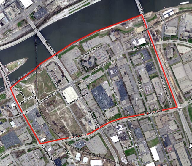
 In a few weeks, Saint Paul is likely to adopt a new plan for the West Side Flats, a large area of former floodplain right across the river from downtown Saint Paul. While there’s a lot of agreement about the majority of the plan — dense but not-too-tall mixed-use, a reconnected street grid, storm water mediation, bike paths — a debate has popped up about the some of the industrial property covered by the plan.
While I don’t want to weigh in on my exact thoughts about what to do [at least until the Planning Commission votes on the issue], the debate about the flats’ industrial property has brought out a contrast in perspectives on the value and shape of industrial property in urban areas.
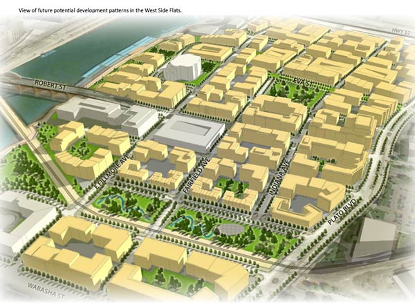
Conceptual rendering of future land use from the Master Plan.
The Uniquely Situated West Side Flats
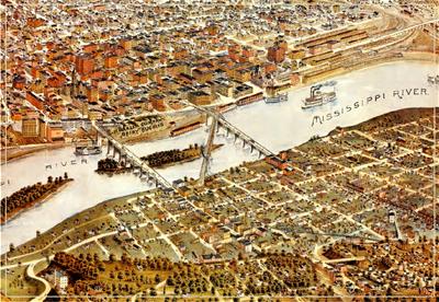 I’ve written about the unique history of the West Side Flats before elsewhere. They’re one of the many former floodplain immigrant neighborhoods that were basically bulldozed during the 1960s, the old working class neighborhood replaced by either empty parkland, featureless single-story office or industrial buildings (surrounded by parking lot moats). Or, in a surprising number of cases, much of the land was simply left vacant.
The elimination of the old neighborhood was particularly vexing because the city erected a protective flood wall at the same time, and today walking around the desolate land is to occupy an empty heart. The neighborhoods up the bluffs (where I live) seem far removed from downtown and the rest of Saint Paul, lacking the continuity and connection that they had in the past.
That’s why the new master plan is so encouraging. It promises to re-connect the West Side with downtown by infilling the flats with a bustling new neighborhood. But some of the plan’s property has raised the hackles of the Chamber of Commerce and the Saint Paul Port Authority (a quasi-governmental agency which develops a lot of the city’s industrial land). Basically, these groups would like to keep the existing light industrial street grid and densities between Robert Street and the (elevated) Highway 52, and have now written letters asking that the city scrap the plan. Their reasoning raises key questions about how cities should asses the value of different development proposals.
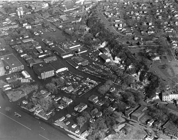
The flats during the great flood of 1952.
Industrial Tax Value vs. Tax Burden
For the most part, the Saint Paul Port Authority has done a good job at the impossible task of buying and redeveloping old industrial parcels. There are good projects (for example, the Phalen corridor) and bad ones (see: Westgate). But every city and suburb in America is competing for industrial tax base, and it can’t be easy to rehab old urban industrial land and deal with white elephants.
A few years ago, the SPPA commissioned a study called An Industrial Strategy for the City of Saint Paul, that makes a case for why the city should focus on developing industrial land. The study offers a lot of useful information about economic trends around the country and paints the delicate picture of why (entry-level) industrial jobs are so important for the region. But it also makes a curious argument that plays a big part in thinking about how a city like Saint Paul should use its urban industrial land.
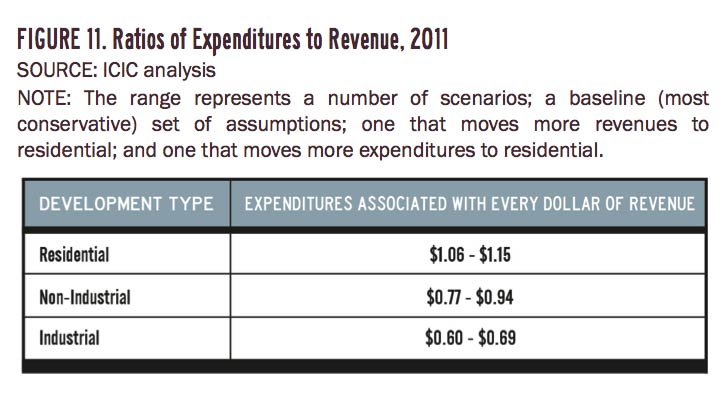 One of the key arguments of the study (referred to as the ICIC report) is that industrial land has a higher return on investment for Saint Paul than residential land uses. Here’s what it says:
To estimate the impact of different activities on fiscal outcomes, costs and revenues in Saint Paul were analyzed, using additional studies and the project team’s research in order to better understand the impact of residential and employment growth on fiscal conditions in the city. Based on a range of scenarios, we found that on average, existing industrial activities generate significantly more in revenue than they consume in city services.
As shown in Figure 11 [above], we estimate that industrial activity consumes only $0.60 to $0.70 in city services for every $1.00 in revenue that it generates. Note that the impact of visitors on city costs on city services is not accounted for, meaning that each the cost per dollar of revenue may be overstated across each of the three categories in Figure 11. While the impact of excluding visitors on each type of development is identical, the relative cost of each is not affected; in other words, it is possible that residential activity generates more revenue than it consumes but it will remain roughly 50 to 90 percent more expensive per dollar of revenue than industrial activity.
Over my years hearing testimony, this statistic has popped up again and again. But each time it strikes me as odd. If residential land loses money for the city, why do we keep building it?
Reading through the fine print, it’s not exactly clear how the ICIC report came to this conclusion.* As best as I can tell, they attempted to take all of Saint Paul’s annual expenditures and ‘divide them up’ amongst all the different ‘users’ of city land. (E.g., the fire department budget would be split up between the different calls according to land use type.) Thus you discover how much of a ‘tax burden’ each different land use is for the city budget. And lo and behold, industrial land ends up being the only type of land that ‘turns a profit.’
Contrast with The Strong Towns Approach to Value
The idea that a city full of (fully leased) industrial property would be an economically successful one seems reasonable on its face. After all, businesses do pay property taxes, and do have ‘trickle down’ agglomeration effects for other city businesses.**
But at the same time, the idea that the best use of urban land (particularly land close to downtown) is a single-story building surrounded by surface parking seems to fly in the face of the years of research I’ve been reading from groups like Strong Towns. For example, a few years back Chuck Marohn wrote a post about the “nature of productivity” where he compares downtown-style mixed-use development with auto-dependent “STROAD” patterns:
The traditional development pattern of the downtown not only starts the productivity race 72% ahead of the STROAD, it has lots of opportunity to grow. All of the parking can easily be converted to more productive uses. When that low hanging fruit is consumed, all of the buildings can be improved. The second and third floors can be recaptured, renovated and remodeled. This doesn’t require one sugar daddy but can be accomplished through the organic functioning of many different players. And when this happens, it won’t suck the life out of the surrounding properties. To the contrary, this can only happen successfully in conjunction with the surrounding neighborhoods. Even though the current downtown is far more financially productive than the STROAD, the current atrophy and decline should be the low point. With a little different focus, it is easy to envision the value of these nine downtown blocks doubling, tripling or more.
Granted, retail and industrial property have different wage scales, but the overall land use patterns are similar. The key difference between the “strong towns”-type analysis of value and the ICIC report’s approach is that land is considered on a per-acre basis. The crucial question: How much return on investment (or “value”) does a particular land use offer per acre? This seems different than looking at overall tax revenues and expenditures, where land uses are simply considered in the abstract.
Two development patterns in greater Brainerd; image from Strong Towns.
And I’d be wiling to guess that adding in ‘per-acre’ accountability would dramatically change the conversation about properties like the existing West Side Flats development. This is important because a city like Saint Paul is going to be paying for a certain amount of services on a per-acre basis and a certain amount of services on a per-person basis. In other words, the rate of expenditure does not increase at the same rate as the rate of population. Thus, increasing the density of the city, in general, would improve the overall efficiency of service delivery, and decrease the ‘burden’ of residential land uses on the city.
Per-Acre Analysis for the West Side Flats
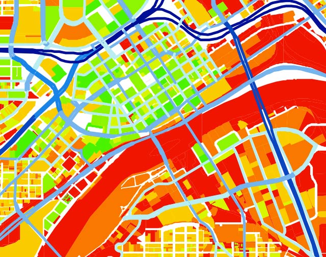
Scott Shaffer’s land value maps show the disparity on the West Side. Red is low value, green is high.
Frankly, I don’t quite know how to reconcile these opposing analyses. But my rough sense of the situation is that whether or not industrial property is the “best use” for an area greatly depends on context. For example, in a place like Phalen Corridor on the East Side (or Beacon Bluff nearby), where there isn’t very much alternative development, industrial uses are surely a great idea.
But in a place like the West Side Flats, where property values are absurdly low compared to the downtown land just across the river, there are surely alternatives that would be more economically rewarding for the city, both in agglomeration effects, property tax receipts, and in producing local jobs.***
Placing a definitive value on industrial land uses is very tricky, particularly on a municipal rather than a regional level. It’s probably best to avoid easy answers, and saying that “industrial land is the only kind that pays for itself” is an over-simplification that does cities no favors if it neglects the opportunity cost of potential mixed-use neighborhoods. I’d suggest that cities like Saint Paul look at industrial properties on a case-by-case basis that pays close attention to context, while keeping its focus on connecting the now disparate mix of urban land uses into a cohesive and walkable whole.

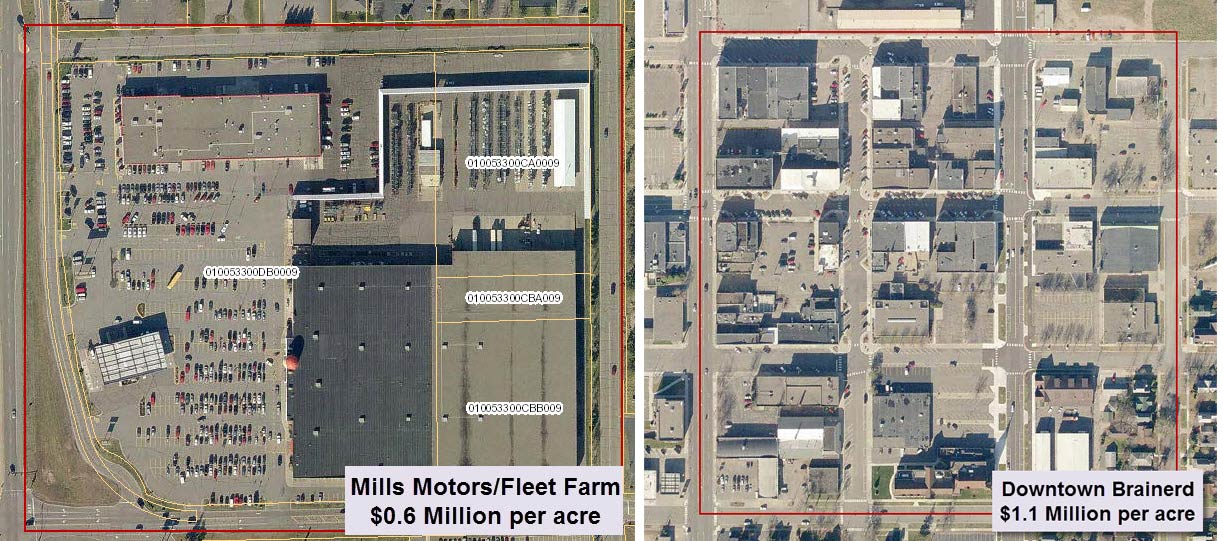
Development patterns of the flats (left) and downtown (right) at the same scale. These sites are 2/3 of a mile apart.
* The report states that “details about sources and methods can be found in the technical appendix on this topic.” * Note: I contacted ICIC a few days ago to try and get my hands on the Appendix mentioned, but haven’t heard back from them.
** Agglomeration effects are tricky, and depend a great deal on how much time and money employees might spend in the city itself. For example, each time a worker goes out to lunch, the local pizza place does better. But in my experience (and you’ll have to take my word for it here), most urban industrial workers do not actually live in a city like Saint Paul. (For example, wt a recent hearing on a West Side Flats property, all the testifying workers gave addresses in places like Prior Lake, White Bear Lake, Ham Lake, Inver Grove Heights, etc.) I’m sure it’s not a hard and fast rule, but in general, a city like Saint Paul has to ask itself about local benefits. Is Saint Paul simply a good location for a warehouse or factory, conveniently proximate to freeways?
*** In the case of the West Side Flats, the master plan is a long-term situation, 30-40 years out in the debated area. The plan does not suggest re-zoning or removing existing businesses. Rather, the plan is attempting to sketch out a general framework for how to develop the under-used land.