August 2, 2014
Lexington-Hamline, Summit-University, Midway, Como
14.5 miles
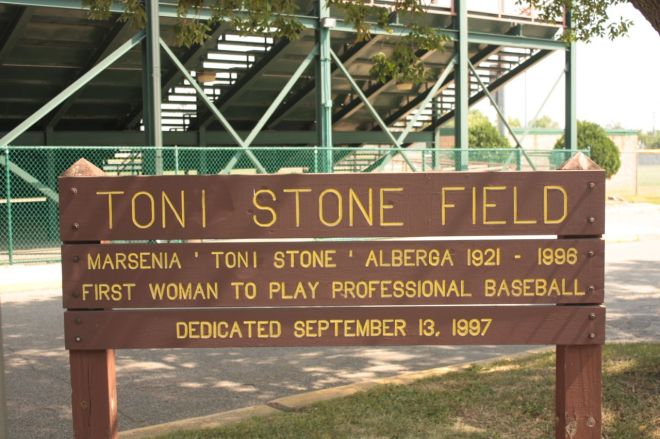
Athletes and sports have played a big part in Saint Paul history. In recent years much of the recognition has gone to those from Cretin-Derham Hall High School. Decades ago, however, several neighborhoods, especially the East Side and the Midway were well-known for their athletes and teams. One of the best baseball players to come out of any Saint Paul neighborhood is not who you think. It happened to be an African-American woman named Toni Stone. I knew a little about Toni Stone and her baseball legacy and I learned more with a stop at the stadium that bears her name.
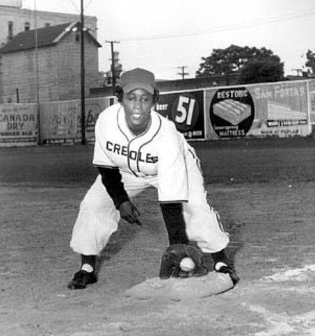
Most sources credit Toni (given name Marcenia Lyle Stone) as the first woman to play in the Negro American League, with the Indianapolis Clowns, in 1953. I found conflicting information while researching Toni Stone. Some of the confusion was intentional–to enhance Stone’s appeal to fans. For example, promoters claimed she was 10 years younger than her actual age and was paid much more than she truly made. However, Toni’s given first name is spelled differently on two signs at the field bearing her name. Compare the previous two pictures to see what I mean.
Toni was born in Saint Paul in 1921, seemingly on a baseball diamond. By the time she was 16, she was pitching for the men’s semipro Twin Cities Colored Giants. Other stops during her career were with the semipro San Francisco Sea Lions and New Orleans Creoles and the Negro American League’s Indianapolis Clowns and Kansas City Monarchs. After one season each with the Clowns and Monarchs, Toni Stone retired from the Negro Leagues after the 1954 season with a .243 batting average but continued to play amateur ball for many years.
Never having been inside Toni Stone Field and finding the gate locked, I felt it my duty to climb the fence next to the bleachers to gain access, not for me, but for you, the followers of my blog.
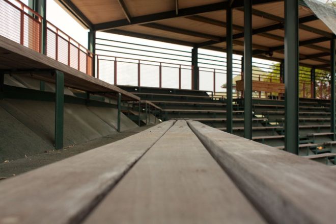
A look-see along the bleachers toward the middle of the stadium. The wood table on the right background is the press area.
As you can imagine, Toni faced the same race-based adversity as male players in the Negro Leagues. But she also endured the hardships of being the only woman on the team, including being shunned by many teammates.
Toni Stone died in California on November 2, 1996 at the age of 75 but thanks to her groundbreaking success in baseball and this field, she’ll be remembered for years.
The Wilder Foundation headquarters is at the southwest corner Lexington Avenue and University. Wilder is a philanthropic organization started in 1906 by Saint Paul businessman Amherst H. Wilder to “relieve, aid and assist the poor, sick and needy people of the city of St. Paul.”
In more than 100 years since its inception, the Foundation has provided many health and human services to Saint Paul residents, including some that weren’t available anywhere else in the City. Examples of the Wilder services from the first several decades of the 1900s are public health nurses and the Wilder Baths and Pool, which gave those with inadequate or nonexistent bathing facilities a place to clean up.

Signatures of Amherst, Fanny and Cornelia Wilder were etched into the building facade. This is Amherst (A.H.) Wilder’s signature.
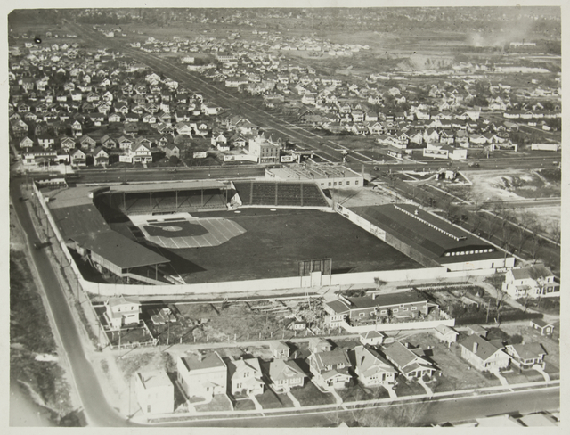
The Wilder Center is linked to Saint Paul’s baseball history in that it sits on the spot of Lexington Park, home of the original Saint Paul Saints from 1897 through the 1956 season. A brass marker commemorating Lexington Park sits on the spot of the stadium’s home plate (although I couldn’t find it.)

The Minneapolis Millers and Saint Paul Saints get ready to square off in the battle of the Twin Cities at Lexington Park in 1926. Courtesy Minnesota Historical Society.
The original Saints moved to Midway Stadium for 1957 and the ‘new’ Saints played the last game ever at Midway last August.

Now north of University Avenue, I found Griggs Playground in the midst of renovation at North Dunlap and West Hubbard. (Griggs Avenue borders the western side of the playground, hence the name.)
McMurray Athletic Fields are 32 acres of softball, soccer and football fields between Como Avenue on the north, Jessamine to the south and Lexington on the east. Como Avenue separates McMurray from the southern edge of Como Regional Park.

These solar-powered electric car charging stations are something I’ve not seen at any other public facility in Saint Paul but McMurray.
These athletic fields opened in 1927 and named two years later for William McMurray, an Irish-born tea merchant. McMurray was a financial benefactor of many good causes as well as the donor to the City of 25 acres of land along Battle Creek that became part of the park with the same name (from The Street Where You Live: A Guide to the Place Names of St. Paul, Donald Empson).

Saint Paul’s Animal Control Center is just across Beulah Lane from McMurray. The old school name for it is the dog pound. According to its website, Animal Control officers respond to violations of animal ordinances, impound stray or dangerous dogs and investigate reports of animal bites.
I don’t know whether it’s a coincidence or not, but the Saint Paul office of the Animal Humane Society at 1115 Beulah Lane is next door to Animal Control.
As I rolled by, I met Faith Donovan, a Humane Society volunteer officially known as a “dog adoption support person,” who was walking a puppy named Lexi.

Faith Donovan and four-month old Lexi walk along Beulah Lane and one of the McMurray Park baseball diamonds.
Faith explained reason for volunteering with the Humane Society this way, “In Duluth I have four dogs and I miss them a lot and I can’t have dogs where I’m living currently, so I come and volunteer at the Humane Society. That way I can get my dog fix and then go home.”
Faith added, “I just find that animals are really healing and very therapeutic and when you know you’re having a bad day, to just get to walk dogs and play with them, it’s just really relaxing.”
Faith mentioned that the Humane Society started a program for dogs who aren’t ready for adoption. “Walk Stars” go through rehabilitation for behaviors like guarding their food or a history of biting, so ultimately they can be adopted. She added, “…they started up this program so that they could reduce the amount of euthanizing that they have to do.”

Every animal up for adoption at the Humane Society is accompanied by fact sheet like KotKu the cat’s.
Beulah Lane is less than a block long. It runs into Como Avenue and Como Park. That’s where I came upon the obviously new sign for the park’s outdoor classroom.
 This seemed like a good place to hop off my bike and on to the outdoor classroom’s trail. A couple dozen steps later I came to a clearing in which stood a sizable stone fireplace.

The stone fireplace, I later learned, is a memorial to Joyce Kilmer, writer, poet and World War I hero.
I didn’t see any historical marker or other explanation about the fireplace or its significance. Not until I researched the Como Woodland Outdoor Classroom did I discover the fascinating account of this monument.
In the 1930s, Saint Paul Parks Department officials proposed setting aside a small slice of woods in the southwest part of Como Park as an arboretum. Parks Superintendent William LaMont Kaufman designed the arboretum, with the stone fireplace and some gentle waterfalls as focal points.

Parks Superintendent (William) LaMont Kaufman and Parks Commissioner Fred Truax stand in front of the fireplace at the dedication ceremony in 1936. Courtesy Minnesota Historical Society.
In 1935 the United States was still mired in the Great Depression–unemployment sat at just over 20%–so Kaufman sought and got funding from the Kilmer Post of the American Legion for the project. Men in the Works Progress Administration (WPA), part of Roosevelt’s New Deal, began construction of the arboretum, including the Joyce Kilmer Memorial Fireplace, that same year. Less than a year later the arboretum and Joyce Kilmer Memorials were dedicated. Kilmer is best known for his poem “Trees”, which begins “I think that I shall never see / A poem lovely as a tree.”

The chimney of the fireplace has the date construction began and the initials of LaMont Kaufman, Superintendent of Parks, and Park Commissioner Fred Truax.
The fireplace and waterfalls, called the Joyce Kilmer Cascade, were very popular and well-used for decades. By the 1960s, however, the fireplace and surrounding arboretum became a nighttime hangout for ne’er-do-wells. Move ahead to the 1980s and the Kilmer Cascades had been, for all practical purposes, destroyed by vandals and the arboretum overgrown. The fireplace also showed its age but not to the same extent (from Kilmer Fireplace Re-dedication booklet, Sharon Shinomiya, Deb Robinson and Katie Plese; Como Woodland Advisory Committee ©2011).
In 2003 local volunteers pitched in to clean up the garbage and invasive species in the arboretum. Three years later planning began in earnest to formally restore the area, but it took until 2010 for the project to land funding. The fireplace re-dedication ceremony took place on May 19, 2011.
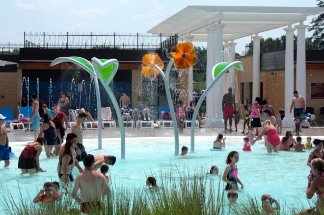
Also on Como Avenue, less than a block east, is the revitalized Como Pool. More a water park than traditional municipal pool, the lively and colorful Como Pool reopened in June 2012. (I would have enjoyed a swim today.)

It’s no surprise there’s a line to get into the Como Pool on a sunny Saturday with the temperature in the 80s.

The “aquatic climbing wall” and zip line (right) and oodles of lounge chairs are a couple of the reasons for the pool’s popularity.
From the Como Park Pool, I basically went around the McMurray Athletic Fields, continuing east on Como, south on Lexington, then back to Jessamine and west again.

The Como Central Service Facility houses the Parks and Recreation Department’s Operations Division. The address is 1100 Hamline although the building faces Jessamine.
Continuing west, Jessamine ends at Pascal Street where a large parking lot is filled with semi-trailers. Just down the street and around the corner on Brewster Street, there are two unique public charter schools. The first is the Metro Deaf School.

The Metro Deaf School offers a bilingual education using American Sign Language (ASL) and English for primarily deaf, and hard-of-hearing students, according to its website.
The Hmong College Prep School is next door at 1515 Brewster.

The Hmong College Prep School is the first Hmong-focused high school in the US and has more than 900 students, according to the school’s website.

Trailers line one side of the parking lot at 1102 Snelling Avenue. In the background you can see the Metro Deaf School and Hmong College Prep.
Around the corner, on the East Snelling Avenue frontage road, is the lot of semi-trailers and garages filled with school buses.

A third charter school, the Dugsi Academy is on the Snelling Avenue West Frontage road. About 300 students attend Dugsi.

Just north of Dugsi Academy is this plain building. The sign gives a clue as to what the McDowell Agency does. On either side of the sign, you’ll notice, are fingerprints, and the company is a private investigation firm that specializes in background investigations, according to the website. It goes on to say products and services include “criminal background screening” and the nebulous “additional verification services” and “industry specific services.”
The ride-by of the West Snelling Frontage Road concluded the discoveries for the ride. The map of the entire journey is here:
http://www.mapmyride.com/routes/view/642205132

