
By 2024, the B Line will be operational and provide rapid bus service along Lake Street, Marshall Avenue, and Selby Avenue between West Lake Station in Minneapolis and Downtown St. Paul. Just north of Lake Street is a former railroad trench, now partially occupied by the popular Midtown Greenway trail, that for years has been looked at for rail transit due to the dedicated right-of-way and limited number of grade crossings. In 2014, Metro Transit identified light rail as the locally preferred alternative for the Midtown Corridor between the Green Line Extension’s West Lake Station and the Blue Line’s Lake Street/Midtown Station.
This isn’t the first post concerning the implementation of transit on the Midtown Corridor (I’ve mentioned it here), and it certainly won’t be the last since the Metropolitan Council and Metro Transit have pushed this topic aside for the foreseeable future. However, it’s never too early to discuss what is best for the Midtown Corridor. This post will provide an evaluation of the pros and cons of light rail/streetcar vs bus rapid transit (BRT) on the Midtown Corridor, options for extending service beyond the Midtown Corridor, and a recommendation on transit mode for the Midtown Corridor.
Strengths of Light Rail on the Midtown Corridor
Over 100 years ago the Milwaukee Road grade-separated their busy mainline through South Minneapolis due to significant traffic congestion on north-south arterial streets caused by freight and passenger trains. A corridor built for those kinds of trains could also easily work for modern day light rail trains.
The Midtown Corridor goes through one of the densest areas of the Twin Cities in terms of population and employment, and many people who live or work in the area don’t own a car and depend on transit. The demand is certainly there for high-frequency and high-capacity light rail service.

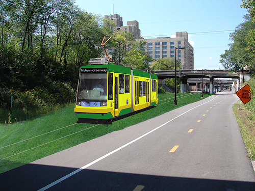
Turf track could be used to maintain the aesthetics of the Midtown Greenway. The light rail trains would operate on electricity, so there would be no pollution issues to deal with. Also in light rail’s favor are rider comfortability and the general preference people have for rail over bus
Weaknesses of Light Rail on the Midtown Corridor
Metro Transit’s final report on the Midtown Corridor shows that light rail would only go as far west as West Lake Station and as far east as Lake Street/Midtown Station, which is just over four miles. This would severely limit the potential of serving more than just South Minneapolis and being a highly useful service. The recommended alignment makes it mostly usable only for trips within the Lake Street area (and even for those trips, people may prefer the B Line) or connecting to a north-south transit route.
The design of the Blue Line and Green Line Extension also implies that a Midtown Corridor light rail would have a short route. On the west end, the Green Line Extension wasn’t designed to allow for interlining of Midtown Corridor trains at West Lake Station due to the tunnel underneath the Kenilworth Corridor, so a separate station platform would be needed. Interlining west of West Lake Station may be difficult due to right-of-way constraints, though not impossible. On the east end, the Blue Line was designed with a future junction in mind that would allow Midtown Corridor trains to interline and serve Lake Street/Midtown Station. However, trains can only go south from there.

Another drawback arises from the aesthetic requests the Midtown Greenway Coalition have made. Turf track was one request, which can easily be fulfilled, but another was maintaining the existing slopes and bridges along the Midtown Greenway in order to preserve the historic character of the corridor. The Midtown Corridor Final Report shows that the locally preferred alternative includes a combination of single- and double-track segments in order to meet that request. The report also shows that either single unit light rail vehicles (LRVs) or modern streetcars would be used on the Midtown Corridor instead of two- or three-car trains that are typical on our existing light rail lines. The single-tracking and single unit LRVs greatly reduce potential frequency and capacity.
While trains could perhaps use batteries instead of overhead wires on the Midtown Corridor, there’s no guarantee Metro Transit would accept a sub-fleet of LRVs or streetcars specially designed for only the Midtown Corridor. It’s up for debate whether overhead wires would impact the historic character of the corridor or not.
Potential Extensions of Light Rail
From a feasibility standpoint, the possibilities for extending light rail beyond the Midtown Corridor are very limited. Going from West Lake Station, the only feasible route is utilizing Green Line Extension infrastructure to Shady Oak Station. A pocket track is planned to be built near this station, so Midtown Corridor trains would be able to layover without blocking the mainline tracks.
From Lake Street/Midtown Station there are only two feasible routes. The first would be to continue south on the existing Blue Line and end at Fort Snelling Station. The reason trains would stop here is because of the existing pocket track that could be used by Midtown Corridor trains to layover without blocking the mainline tracks. Going further south, people would need to transfer to the Blue Line (or Riverview Corridor when that becomes operational).
The second route would go south until 46th Street Station, then turn east and cross the Mississippi River on Ford Parkway. Trains would then go through the redeveloped Ford Site, utilize railroad right-of-way currently owned by Canadian Pacific Railway, and end at West 7th where people could transfer to/from the Riverview Corridor. However, there are traffic concerns due to the need to cross Hiawatha Avenue, as well as taking away space on 46th Street/Ford Parkway. There would also likely be local opposition to trains running on 46th Street/Ford Parkway, and potential design issues with routing through the redeveloped Ford Site.
Strengths of BRT on the Midtown Corridor
The main strength of BRT on the Midtown Corridor is the ability to cheaply and easily extend service beyond West Lake and Lake Street/Midtown. There are more extension opportunities for BRT than light rail both on the west end and east end. BRT can use existing road infrastructure with little modification needed besides for stations. Traffic signal priority and dedicated bus lanes are also possible.
Electric buses can be utilized to eliminate emission concerns, and the buses can be 60 feet long to provide additional capacity (80-foot buses also exist, though these may require extensive modifications to intersections). Metro Transit already operates 60-foot articulated electric buses on the C Line, and more could be used as the technology improves and the rapid bus network expands.

The busway on the Midtown Corridor doesn’t have to be the usual asphalt road. Turf in between concrete tracks is used on the Cambridgeshire Busway in Cambridge, England and the Leigh-Salford-Manchester BRT in Manchester, England. In addition to aesthetics, it also allows buses to operate at higher speeds, and docking at station platforms is more precise for easier boarding/alighting.

If preserving the railroad trench as much as possible is a high priority, buses can operate in a single lane for short segments like trains can do on a single track. In fact, it’s likely easier for buses to share a single lane than trains sharing a single track due to the need for tracks to have switch equipment that must be maintained. If a switch fails, this can severely impact light rail operations.

Weaknesses of BRT on the Midtown Corridor
Assuming a concrete guideway is used for buses on the Midtown Corridor, this would require buses to be fitted with guide wheels on the sides of buses. However, the guide wheels can be installed on any bus and they’re easy to install or remove. Bus guideways like the two examples in England are extremely rare, so logistical concerns such as drainage, snow and ice clearing, and the freeze/thaw cycle would likely require further study before committing to it.
While BRT is in theory light rail on rubber wheels, the rider comfortability isn’t quite the same, and rail bias is still there no matter how many upgrades you put into a bus route. BRT ridership between West Lake Station and Lake Street/Midtown Station would likely be lower than light rail. However, the additional ridership from an extended route could make up for that.
BRT also has lower capacity than light rail even with longer articulated buses. New Flyer’s Xcelsior CHARGE 60-foot electric bus, used on the C Line, can seat up to 52 people plus room for 73 standees. The Siemens S70, used on our light rail lines, has space for approximately 231 people (including seating for 63 people). Although the assumption for light rail on the Midtown Corridor is using single unit LRVs rather than two- or three-car trains, this is still nearly twice the capacity of an articulated bus. There is also more space for wheelchairs, luggage and bikes on LRVs (anecdotally, however, I’ve found it easier loading/unloading my bike on the bus than the light rail).

Electric buses, while proven technology, require charging infrastructure at bus garages and at the termini of routes. There have been issues with charging infrastructure for the C Line, and the Metropolitan Council may be going back on its promise to order more electric buses. However, battery technology is always improving, so we shouldn’t consider electric buses unworkable in our environment just because of the hiccups the C Line has experienced.
Potential Extensions of BRT
From West Lake Station, two extensions have been identified as the most feasible for a Midtown Corridor BRT service. Both would continue west along the Midtown Greenway and Green Line Extension until France Avenue, and then turn south. At the intersection of France & Excelsior Boulevard, the first option would continue south on France and utilize existing rapid bus stations built for the E Line between 44th Street and Southdale. From Southdale, buses would continue south and serve the Centennial Lakes area of Edina. The E Line would be rerouted to Xerxes Avenue between 44th and Southdale.
The second option would turn west onto Excelsior Boulevard and end at Downtown Hopkins. While some may argue this would be redundant with the Green Line Extension, it could provide easy connections to destinations along Excelsior that are just outside of walking distance from Green Line stations including Excelsior & Grand and Methodist Hospital.
From Lake Street/Midtown Station there were also two extensions identified as being the most feasible. The first would continue east on Lake Street, turn north at Minnehaha Avenue, and then rejoin the right-of-way used by the Midtown Greenway. After crossing the Mississippi River, buses would turn north and serve the Stadium Village area. However, this route is only feasible if Canadian Pacific Railway abandons their right-of-way that includes the bridge across the Mississippi River. As of now there is no indication they intend to abandon it, as the rail line is still used by the Minnesota Commercial Railroad to serve a couple industries along Hiawatha Avenue.
The second option would continue east on Lake Street across the Mississippi River into St. Paul, turn south on Cleveland Avenue, and then turn east onto Grand Avenue, going all the way to Downtown St. Paul. In addition to residents and businesses along Grand Avenue, this route would also serve St. Thomas and Macalester College. Grand Avenue has been looked at for rapid bus service as part of Metro Transit’s Network Next initiative.
Recommendations
The locally preferred alternative for the Midtown Corridor from 2014 needs to be reevaluated before we commit to a light rail service that’s labeled as a streetcar and only goes four miles. A partially single-track light rail line using single-unit LRVs combines the lower capacity of a bus route with the difficulty of building an extension. Metro Transit’s recommendation for the Midtown Corridor emphasizes fashion over function to avoid altering a railroad trench as much as possible.
Light rail and BRT on the Midtown Corridor both have strong pros and cons. If we want a high-capacity shuttle service through South Minneapolis, then fully double-track light rail with the ability to operate two-car trains is the best option. If we want to extend service beyond the Midtown Corridor in order for it to be a more useful service, then BRT is the best option.