To a Minnesotan like me, the public transit in Milan, Italy is so good that it’s both stunning and frustrating. It stuns because it is so efficient, practical and widely utilized, and it frustrates because my own transit system in the Twin Cities is so brutally inferior.
More People, Fewer Problems
At rush hour, four different subway lines come every three minutes, while the Twin Cities offer a measly two rail lines coming every 15 minutes. Half past 1 on Saturday nights, Milanese buses don’t even have any seats available. Walking a couple blocks in any direction seems to take you to some kind of transit stop.
Many things about Milan, where I am studying this spring semester, are quite different from the Twin Cities. But the city’s distribution of people might be the single most important difference behind the city’s superior transit system.
This argument is advanced by the urban economist Alain Bertraud in a paper titled “The Spatial Organization of Cities.” Bertraud argues that the distribution of people in a city — as measured by its population density and its monocentricity — defines a city’s capacity for public transit. Milan is dense and built around a clear city center; the Twin Cities are much less dense and organized around multiple, weaker city centers. These two characteristics deeply influence each urban area’s transit, enabling a highly effective transit system in one city and restricting a lackluster system in the other.
Let’s take each characteristic in turn. Population density’s influence on transit is fairly intuitive: the denser a city is, the more people are moving around in a given area. Each transit stop sees more travelers getting on and off, and so running frequent routes with comprehensive coverage makes sense.
Bertraud illustrates this point by comparing Atlanta and Barcelona, which in 2005 had comparable populations and fairly similar lengths of metro networks. But in more sparsely-populated Atlanta, almost none of the population lives near transit stops, and so it’s hardly surprising that transit represents a marginal proportion of trips. With its low density, Atlanta would have to increase its metro network length by about 45 times if they wanted to match Barcelona’s population coverage.

Does the (City) Center Hold?
It’s not just the density of people that influences how well transit can work, however. Equally important is how those people are spatially distributed. Cities that are monocentric — that have a single, predominant center of population, jobs and amenities — are much more favorable to public transit than polycentric ones.
In monocentric cities, people making trips (to work, play, visit others, etc.) are typically going to and from a cluster of destinations in the center, and public transit can capitalize on these common routes. Polycentric cities face a greater challenge because trips neither start nor end at any concentrated center. In two hypothetical cities with the same population density, the monocentric one will more easily support effective transit coverage.

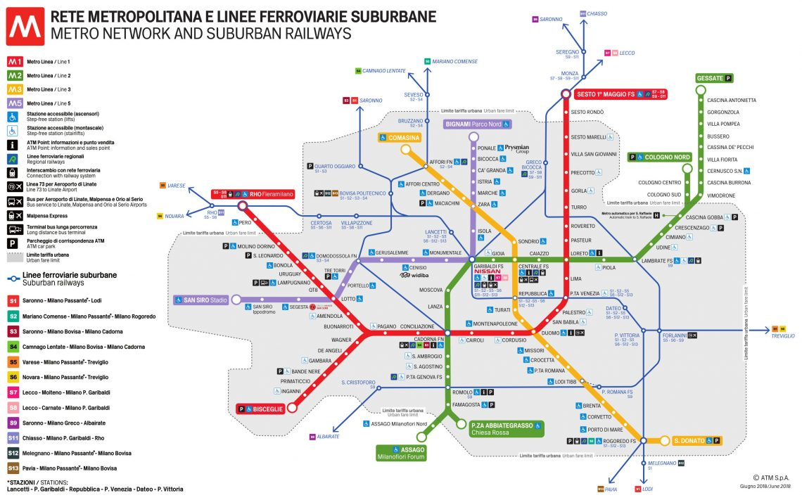
Milan has a clear city center where most urban activity happens, and this centrality is reflected in the city’s transit network. On a map of the city’s four operating underground light rail lines, you can see that there is a clustered center area through which all rail lines pass on their way to and from the outer areas.
While the Minneapolis core acts as a relatively predominant center for the Twin Cities, it is not monocentric in the same way that Milan is. People’s local trips are much more varied; the transit system is less likely to have well-serviced “core routes” because the core routes are not as well-defined.
Urban form is not the sole reason for weak transit in the Twin Cities (and across the country). We don’t always nail practical planning choices, picking routes that don’t make sense or stop too frequently. Likewise for implementation — even the best transit lines can get bogged down by traffic and poorly-timed red lights. We need to make political decisions to invest in transit; even if demand for transit greatly increased we’d still need to address driver shortages. Even when we do sizably invest in transit, the dollars don’t always go far, with recent research highlighting the overspending omnipresent in American transit construction.
Yet while these other factors also define the quality and quantity of our transit systems, our urban form shapes the space of viable transit paradigms. We should address these other transit challenges in the Twin Cities and elsewhere. But improving the Twin Cities’ transit network with our current population distribution is like walking through molasses upriver.
Transforming Our Urban Form
In his paper, Bertaud warns us that “urban shapes are path dependent. The spatial structure of large cities evolves very slowly and can evolve only in a few directions.” We will never shrink Atlanta into a city as dense as Barcelona, or reshape the Twin Cities into a Milan-style monocentric urban area.
However, this lens also points us towards policy decisions that are within reach and would contribute to a better transit system. At the local and regional level, we could improve our decision-making around land use regulations and infrastructure investments to foster an urban form that would support effective public transit.
The land use improvements that we can make are fairly familiar. Generally, any form of regulation that restricts urban development — apartment bans, minimum lot sizes, strict height limits, etc. — will both lower density and weaken a city’s monocentricity by dispersing people over more land. Allowing large apartments throughout core cities, missing middle housing in single-family neighborhoods and smaller lots in inner-ring suburbs will each help improve the conditions for transit.
Infrastructurally, we ought to reconsider decisions that favor suburbanization. Our highway system is one of our most substantial infrastructural investments, and it creates an urban form much less amenable to transit. Economist Nathaniel Baum-Snow estimates that a highway built through a city historically caused an 18% reduction in the central city population by enabling suburbanization. Such investments may have benefited those who gained access to cheap suburban land, but they also sucked out demand for urban transit systems. Alternative infrastructural investments that make denser living more functional — good bike infrastructure, well-maintained public space — will help cities densify and support a basis for better transit.
Even under “optimal” policy, urban form will change slowly. But even slow changes toward a different population distribution would make our transit challenges substantially more solvable.
Photo at top courtesy of https://structurae.net/en/structures/gioia-metro-station
Thanks for the well-written article making an important point. To the list of “other factors” that operate within “the space of viable transit paradigms,” I might add that the price of gasoline in Milan is about twice what it is in Minnesota.
Thank you Max. Definitely agree on that; Italy has a gas tax of $3.26 per gallon, unimaginable to any American.
And in a similar vein, it’s generally not so easy to drive to Milan — lots of traffic and little parking — to the point where a few miles’ trip during rush hour can be faster on transit than driving. This is of course due to better planning choices (including some planning choices inherited from long, long ago). But it also ties into the framework described in my article, where more dense areas are less practical to drive in at the same time that transit is better enabled.
While there’s no doubt that density, population & job distribution have a large effect on transit, parts of this analysis seem flawed.
The paper cited seems to ignore a few things, such as that there are few if any perfectly symmetrical cities with a single core; and most of those are post-automobile and inland flat areas. Most larger cities in the past were started along rivers & coastlines, and have wildly irregular shapes, sometimes across multiple islands, peninsulas, & adjacent to mountains or hills, making them elongated or curved. Their transit systems typically reflect this reality, and are fine.
It also doesn’t really account for New York City, with its business center, Manhattan, being an island with two CBDs, the financial district and midtown Manhattan, with the best and busiest transit system in North America, connecting to all the other boroughs, which themselves used to be independent cities.
Even looking at the Twin Cities or Orange County California, which are highly suburban, their transit systems include a grid of transit lines instead of (OC) or in addition to (Twin Cities) a hub-and-spoke system connecting to the downtowns. Really, we seem to have gotten along just fine with transit mostly based on paths defined by the nineteenth century streetcar system that, like a binary star system, has “gravitational” (concentrated) transit connections between the two downtowns, today including regular & express bus service, aBRT, & light rail.
Finally, Models (c) and (d) in the schematic illustration look more like point-to-point car trips than any transit system.
Every city is unique. There are multiple examples of multi-centered metropolitan areas other than the Twin Cities, including Dallas-Ft. Worth, Quad Cities, Albany-Schenectady-Troy New York, etc. Trying to force these naturally occurring cities into a mono centric model seems phantasmagoric. Much as dictionaries reflect language use (rather than the other way around, as your elementary school teacher might make you think), transit systems need to reflect their unique cities, not the other way around.
Sure, it’s true that no city is perfectly monocentric, and that many cities don’t perfectly fit these conditions while still having great transit systems.
But I don’t see how that defeats the point of Bertaud’s paper. His point is that making good transit systems is much more easy and viable in more dense and monocentric cities. Transit systems do need to reflect their cities, but depending on the underlying city the outcome can be good or bad.
I am not very impressed with where I live in Saint Paul: I can walk 10 minutes to a rapid bus that comes every 15 minutes, or to a normal bus that comes every 30 minutes. This is basically impossible to substantially change, however, because I live among mostly single family homes where people are commuting in many different directions. And that, to me, is a perfect example of the point I am trying to make — good transit can be a lot easier or a lot harder depending on these types of conditions.
But cities aren’t monocentric. It’s such a weird concept. Yes, there is typically one central business district (CBD), but every city has lots of other districts. Mpls has Uptown (former hipster, now dense apartments); Nordeast (hipster, restaurants, bars, housing); UofM (housing, education, jobs); St. Paul has Grand Ave (shopping, entertainment), several universities, Payne-Phalen, Highland Park, etc.
Even suburbs have distinct nodes & corridors. St. Louis Park has a cute “downtown”, a bustling West End, & Excelsior Blvd; Edina’s cute downtown is at 50th & France (and shared with Mpls), whereas its CBD is the Southdale District, which is nowhere near its center, and by far the densest housing & jobs center in the city.
Each of these nodes & corridors has a mix of housing, jobs, shopping, & entertainment, and each has unique transportation needs. It makes no sense to connect these all primarily to the “center” (in Edina, the SE quadrant!). They also need to be connected to each other in some way.
And each of these nodes/corridors helps build a 15-minute city. You can do many/most of your daily needs within any of these nodes, but are free to travel elsewhere within the metro for specific needs (a specialist, an amazing job, friends & relatives, etc.).
I replied but the server ate my response, apparently (I don’t see it).
In a nutshell:
Cities have multiple nodes (Uptown, Nordeast, Linden Hills, UofM, Highland Park, Grand Ave, etc.) in addition to the CBD (Central Business District).
Even suburbs have nodes & corridors (West End, Excelsior Blvd, 50th & France, Cahill Industrial District) and asymmetric downtowns (Edina’s Southdale District is nowhere near the center, and borders 3 different other cities).
Each of these neighborhoods constitutes part of a 15-minute city, where daily activities & errands & sometimes even jobs can be accessed locally, but also using transit gives you access to the entire metro area (for health specialists, amazing job opportunities, friends & relatives, etc.). So each has unique transit needs, and connects to other nodes that are not the downtown CBD.
Even today, the 46 bus connects Edina to multiple BRT lines, LRT, all the way to Highland Park, St. Paul—and it goes nowhere near downtown Mpls. In short: Monocentric is not a policy goal.
Lou, I think you are continuing to misinterpret Bertaud and my argument. Of course it is true that there are many nodes and corridors in urban areas that naturally develop.
But you are fundamentally misconceptualizing cities, as Bertaud uses the term. To Bertaud, cities are dense agglomerations of labor markets and economic activity. In this way, Edina is not a city. Minneapolis, by its discrete borders, is not a city. These are just arbitrary administrative boundaries that carve up the the metropolitan area. When you say that there are many nodes across this metropolitan area, you are not thinking at the samae scale as Bertaud when he describes monocentricity. Let me give you an example from some 2015 data I pulled from Census Commuting Flows (https://www.census.gov/topics/employment/commuting/guidance/flows.html): In 2015, Edina was recorded as having 23,500 commuters. Only 5,600 of these people worked in Edina. 14,000 worked in a different city within Hennepin County, and the rest of the people worked somewhere else. So sure, there are many pockets of urban life in cities, but that is not very relevant. than the overarching economic structures that create a metropolitan area.
If you’d like, return to the paper by Bertaud (https://escholarship.org/uc/item/5vb4w9wb). Look at page 14, “Figure 4: Density Profile of 9 Cities.” What you will see is that every city has some degree of monocentricity: the further you get from the city center, the lower density gets. This is not about particular nodes or attractive urban areas, it’s about net concentrations of people. For a more comprehensive analysis of this, look at the Lincoln Institute’s 2013 paper on this (https://www.lincolninst.edu/sites/default/files/pubfiles/2275_1614_Lewis_WP13RL1.pdf). On page 21, Figure 13, you will see a table of “density gradients” that shows the rate at which population density declines as you go further from a city center. Again, every American city has a negative density gradient, showing that there is almost always some degree of monocentricity.
Because cities are dense agglomerations of labor markets, land in the center is basically always more valuable and basically always more densely developed (again, this is not about individual corridors or nodes; that’s the wrong scale to think about this). But we have a lot of policies that discourage this much-desired central land from becoming more densely developed. Thus our transit does not work very well.
In Milan, are the entrances controlled? Are the trains safe and clean? The Blue line was very convenient for me and I rode it to work for years, until I got fed up with how gross and dangerous it became.
No doubt that these things make a big difference. Milanese transit is safe and clean, including when I’ve taken the bus in the dead of morning.
The metro is underground and has turnstiles at every stop, but the buses and streetcars are actually less controlled than many American buses, as you can board at any entrance and no one checks fare at the door (like Twin Cities rapid buses). Fare checkers do exist, but aren’t out and about frequently — I’ve never encountered one during over a month of daily use.
At the end of the day, the biggest deal is far and away the amount of people on the transit. Nobody is going to smoke a cigarette on the metro cause there’s 200 other people in that train car alone. This is also what gives me a lot of worry about the post-COVID path of transit in American cities. It’s a tough downward spiral for ridership to completely drop out, and then there’s less of a natural social check on problematic behavior, and then even less people feel good about taking transit.
Yeah… I love taking and advocating for transit as much as the next person and have never felt truly unsafe, but it is harder to make the case to others when, for example, a hate crime happened last week at a train station. That really took it from “things aren’t great but it’s mostly overblown, you’ll be fine” to “I understand why you don’t feel you would be safe” when talking to friends, for me.
I totally agree that more ridership will help, but it’s a hard time to gain that ridership when service is cut back and safety issues are at the front of people’s minds. More police isn’t the solution but I worry that’s all we’ll get.
Why isn’t more police the solution? If people are being assaulted on trains and at stations, wouldn’t more police help? If homeless people are using the train as a toilet, wouldn’t police help kick them off?
And if not more police, what is your solution?
Absolutely. The more people ride, the safer and cleaner the trains become. And the fewer people ride, the more dangerous and filthy they become. Which then causes even fewer people to ride. Its a death spiral.
I ditto that a missing part of this conversation is crime and perceptions of risk. I also advocate for more public transit but our cities and current public transit systems needs significant more resources to deal with the despicable way I’ve seen bus and train operators treated by riders and the many issues I’ve witnessed first hand including a car full of people smoking cigarettes for 10+ stops on the green line, fights, threats of violence, open drug dealing and using, blasting of violent/misogynistic music from bluetooth speakers, etc. These aren’t simple things that can be ignored by the average rider, just about anyone who has alternatives to taking public transit does so to avoid this regular occurrence. It’s a real shame because it has the potential to be such a great amenity to the twin cities.
Thanks for a thoughtful and well-researched post. I think your point is well made. Of course, the other issues mentioned in this comments are important, but they are aside from the research you are highlighting here. Milan also had the benefit of growing over time along transit routes rather than the Twin Cities which are trying to insert new routes into unwalkable suburban sprawl.
Minneapolis generally appears to be the only place in the metro actively promoting higher densities with the 2040 Comprehensive Plan. Even St. Paul, which currently has a population density under 6,000 per sq mile, appears to have modest ambitions to grow outside a few places like along the Green Line and the Ford Plant site. The upcoming ABRT routes that serve dense areas seem somewhat promising for increased transit service. However, recent cuts to service on routes like the #7 and #23 through South Minneapolis don’t bode well. These bus routes provide one an hour service for most of the day, which is abysmal. The Red, Orange, Gold and Purple BRT routes are unlikely to move the needle towards more transit use, and I’m afraid that the Blue and Green Line extensions are going to disappoint with ridership following remote work trends.