
May 4, 2023
25.25 miles
Macalester-Groveland, West End, Downtown, Capitol Heights, Dayton’s Bluff, East Side
Plentiful signs of spring this fine May day, starting on the corner of Warwick Street and Randolph Avenue in Macalester-Groveland. I paused to gaze at the cow at 478 Warwick. This particular Holstein changes outfits with the seasons, events and, sometimes, the whims of its long-time owners. Years ago, I talked with Pam Becker about their cow, Rosie. But over the winter I vowed to make periodic visits this year to document the creativity of Pam and her fam.


The Odd Block On the West End
The much-welcomed tracks of a freshly swept street greeted me on the West End’s Oneida Street. For bikers, it’s a big relief not to worry about wiping out on the loose sand left over from winter sanding and salting operations. Swept streets are as much a beacon of longer, warmer days as are tulips poking above the soil.

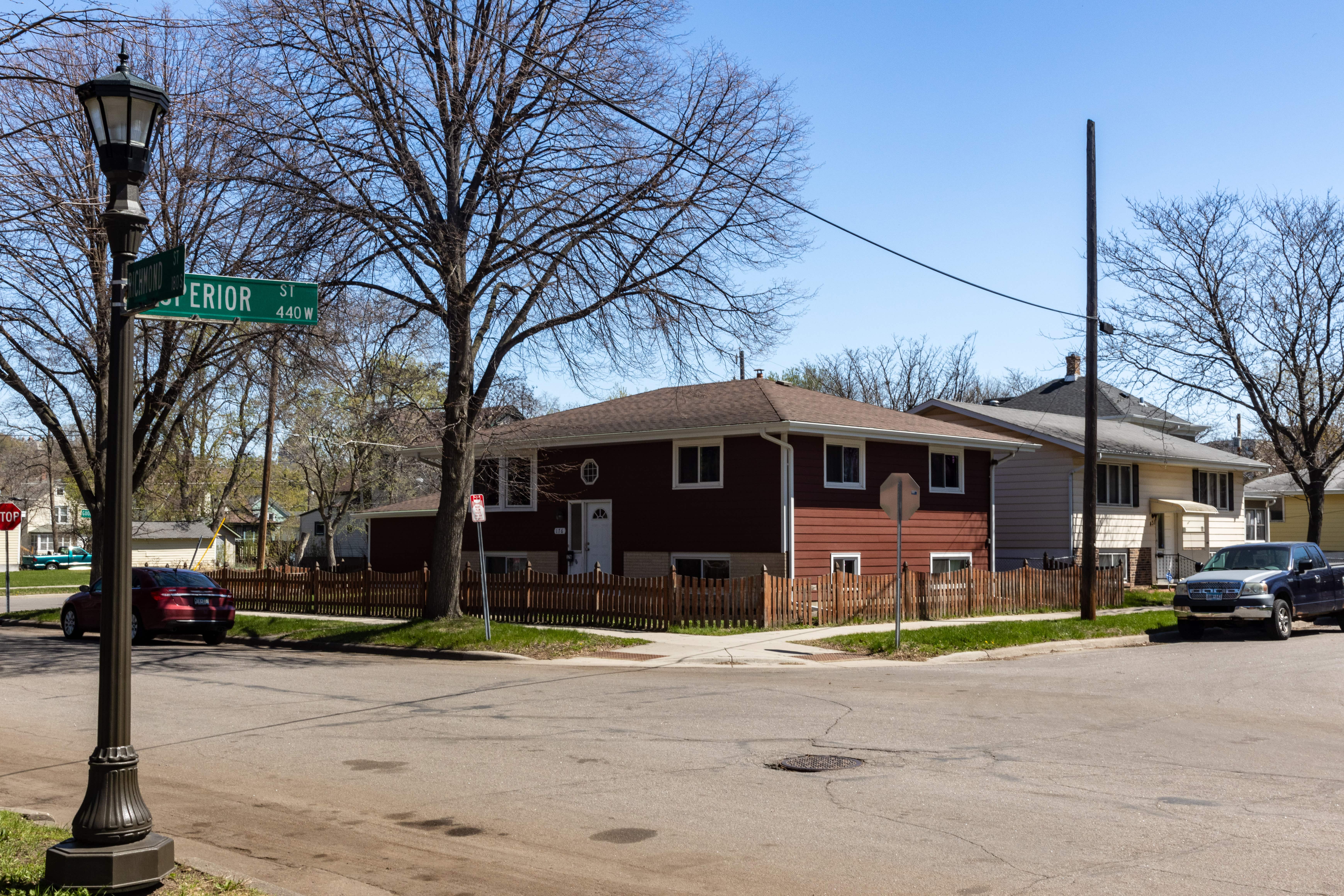
There’s one block in the West End that I’ve biked and driven past many times but until today, never noticed its idiosyncrasies. This single block of properties — bounded by Goodhue Street on the north, Superior Street on the south, Western Avenue on the east and Richmond Street to the west — is just 60 feet, or one lot, deep (see map below).

While plenty of oddly shaped and sized lots dot all areas of St. Paul, I’ve never noticed a block with small single lots like this. A majority of properties with single-family homes or duplexes are between 100 feet and 130 feet deep.
It appears this irregularity was planned. Plat maps as far back as 1874 show the Goodhue-Superior narrow block. More interestingly, the Goodrich-Superior block immediately to the west (between Duke and Richmond) was also platted as one lot deep.

Eight of the 10 structures on this unconventional block have Superior Street addresses.


The Montessori school on the east end of the block (above) is officially on Western Avenue while the home on the west end of the block (below) has a Richmond Street address.

Downtown and the Capital City Bikeway
The distance from Superior and Western to Downtown is less than a mile, but the meandering route I chose, while longer, kept me off busy streets like West 7th.

The Capital City Bikeway is an expanding network of dedicated bike lanes in Downtown St. Paul. The initial segment of this occasionally controversial bikeway along Jackson Street between University Avenue and Kellogg Boulevard opened in 2017. The argument primarily pits businesses concerned about the loss of parking against bikers’ desire for safer, protected bike lanes.
I jumped on the western end of the Capital City Bikeway at 10th Street and Dorothy Day Place, a logical place to access the trail. However, the alignment of the path here creates considerable confusion for drivers in vehicles exiting eastbound I-94 into Downtown at 10th Street.
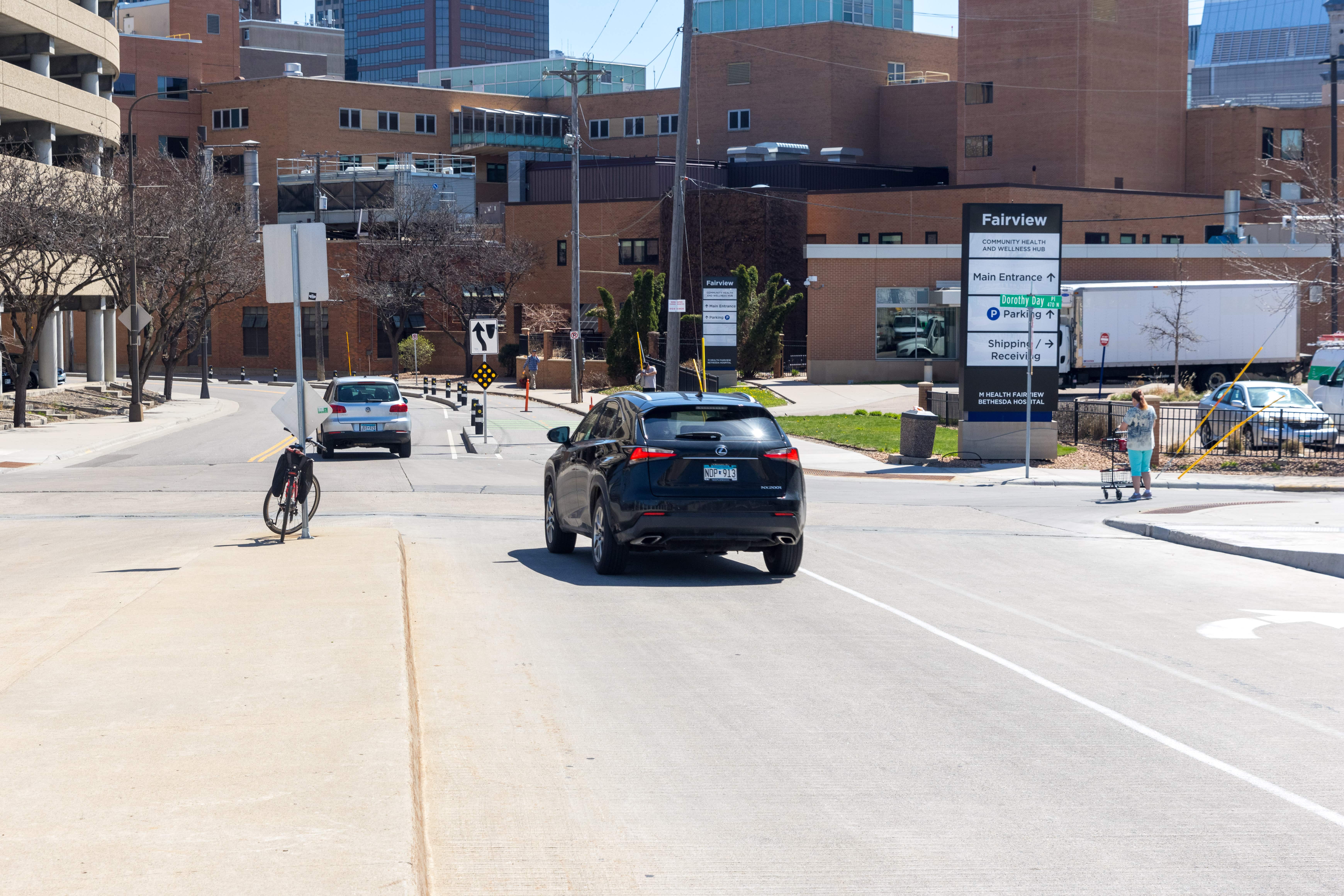
The problem with the trail’s entrance here is that it aligns with where the eastbound lane of 10th Street traffic naturally should be. Eastbound vehicular traffic has to veer one lane to the left to avoid driving on the bikeway, as you can see. On previous trips along 10th, I’ve seen several cars mistakenly drive on the bike lane. Those weren’t isolated mistakes. The two cones in the bikeway have been added as further deterrents to cars traveling east on 10th.


The Parking Ramp that Replaced a Park
Capitol Heights, as its name suggests, is in close proximity to the Minnesota State Capitol. The neighborhood just north of Downtown is minutes from the Capital City Bikeway.

Although almost impossible to imagine today, the neighborhood around the Minnesota Judicial Building, just east and south of the Capitol, was for decades replete with homes and a park, and later, apartment buildings. Even more surprising is that the neighborhood, known as Central Park, was quite fashionable.

The first mansions were built on Central Avenue (old Bluff Street) between Robert Street and Cedar Street in the mid-1850s, although the majority of the large mansions were built in the late 1880s. (Thanks to Jim Sazevich, the House Detective, for clarifying this.) Central Park itself opened to the public in 1885, thanks to four well-to-do families who lived nearby. The Lampreys, Dawsons, Lindekes and Schurmeiers re-platted their properties and each donated some land for the one-block park.

The Uri Lamprey House, Central Avenue, as seen from Central Park. circa 1900. Courtesy Minnesota Historical Society 
The Thomas L Blood residence, 667 Central Park Place West, circa 1888. Courtesy Minnesota Historical Society 
The W. Adams Hardenbergh residence at 665 Central Park Place West circa 1888. Courtesy Minnesota Historical Society 
A mansion, left, and to the right, one of the apartment buildings that went up later across from Central Park, in the foreground, circa 1900. Courtesy Minnesota Historical Society

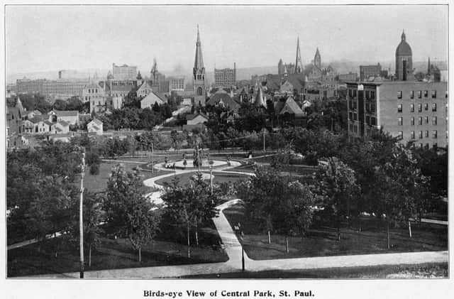
A bird’s-eye view of Central Park in 1898. One apartment building sits to the right in the photo. Minnesota Historical Society 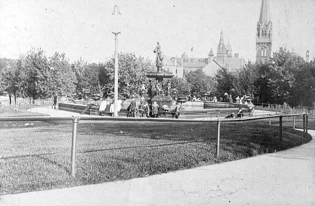
Central Park circa 1900. Minnesota Historical Society 
Looking northwest at Central Park. Note the large homes in the background. Circa 1900. Minnesota Historical Society 
The view of Central Park from Cedar Street circa 1900. Minnesota Historical Society 
Central Park with the Capitol in the background, circa 1905. Minnesota Historical Society 
Children swimming in the Central Park fountain circa 1925. Minnesota Historical Society
The lovely Central Park stood for about 90 years on the spot now occupied by the three-level Centennial Parking Ramp. If not for a one-foot-by-one-foot bronze plaque affixed to one of the ramp’s concrete supports, details of the park and the exclusive neighborhood that surrounded it likely would have been relegated to obscure writings at the Historical Society.

Farewell Bethesda Hospital
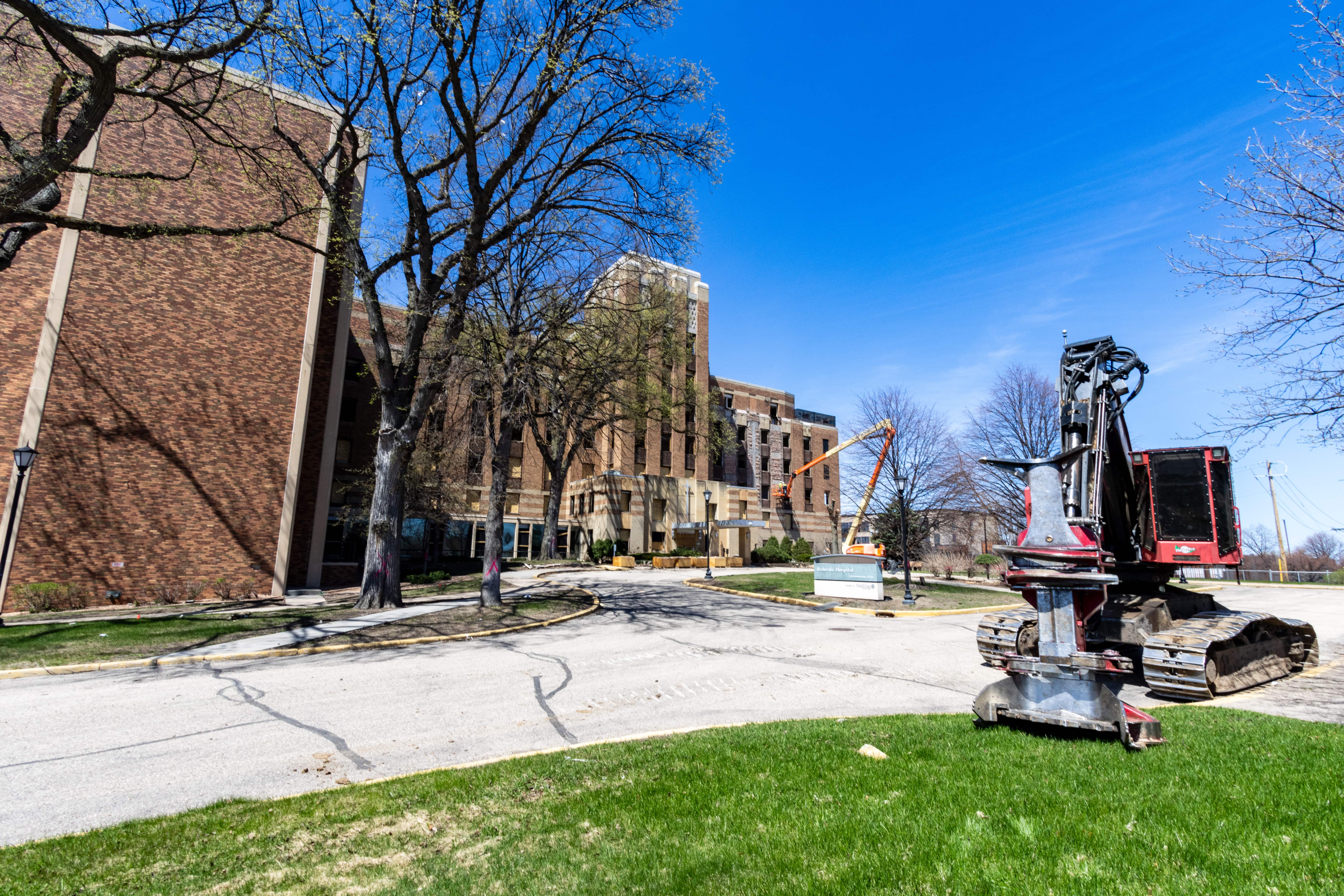
The former Bethesda Hospital building’s days were quickly coming to an end when I visited on May 3. Now, nothing is left of the long-time Capital Heights mainstay. The hospital was established by a Lutheran society in 1882, and “opened, closed, reopened and moved several times in its first ten years of existence,” according to the Gustavus Adolphus Lutheran Church Archives.


The 10-story Bethesda Hospital building being demolished opened in 1932, with expansions in 1959, 1965 and 1982. For decades Bethesda operated as a “community hospital,” providing emergency and other traditional hospital services to nearby residents including those in the North End and East Side. About 1989, its care focus shifted from short-term to long-term care and rehabilitation. In the midst of the Covid-19 pandemic, Bethesda shifted from long-term care to COVID-19 care until its closure in November 2020. Follow the links, below, to see what the interior of Bethesda looked like during its time as a COVID-19 hospital.

Windows have been removed from the 10-story original Bethesda Hospital building. 
The former main entrance to Bethesda was boarded up to limit unauthorized visitors. 
Workmen removed bricks from the main structure of what was Bethesda Hospital on May 3, 2023. 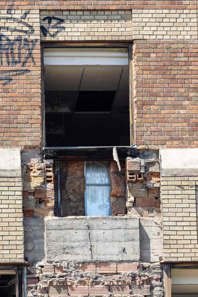
Plans called for preserving some of the Art Deco frescoes that decorated the building. 
Even with the windows removed, it’s easy to recognize the old Bethesda Hospital tower’s Art Deco style.
While Bethesda staff cared for its last patients in 2020, it didn’t spell immediate doom for the building. Ramsey County leased the former hospital, which it used as an emergency homeless shelter.
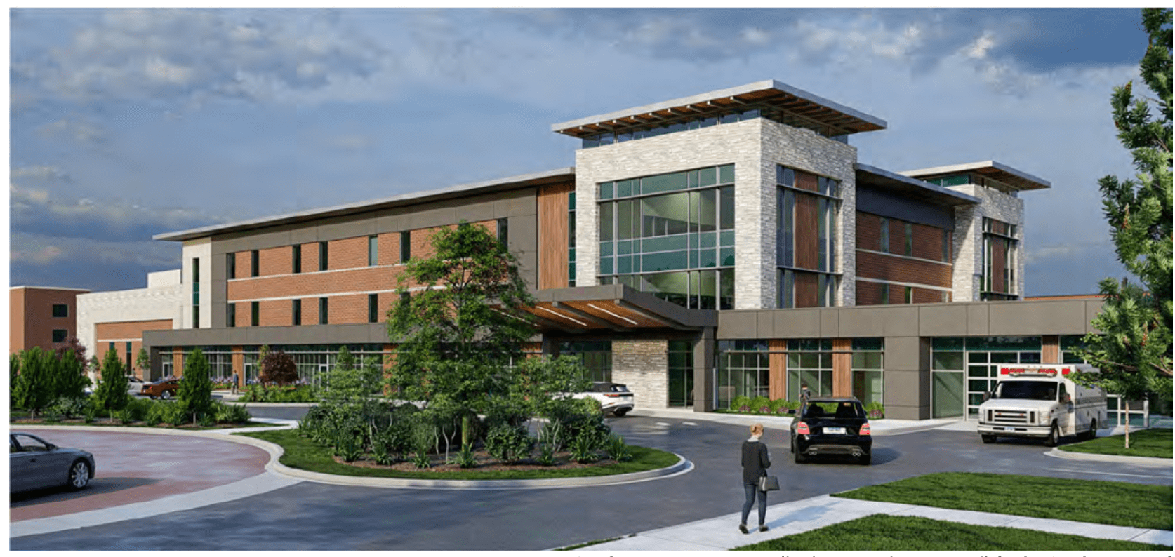
In May 2022, Fairview Health Services retook possession of the empty building. The final nail in the coffin of the Bethesda building came the same month with legislative approval of M Health Fairview’s plan to replace it with a 144-bed in-patient mental health facility.

Seeger, 3M and Arcade Street

The intersection of Arcade Street and what is now Neid Lane was for decades a bustling industrial hub.

Seeger Refrigerator (which became Whirlpool) and the 3M headquarters and campus were the two largest and best known. Hundreds more worked at the Hamm’s Brewery a few blocks south.

A Seeger dry-air siphon refrigerator circa 1900. 
An early Seeger Refrigerator ad in Woman’s Home Companion magazine April 1912. 
The sprawling Seeger factory, date unknown. 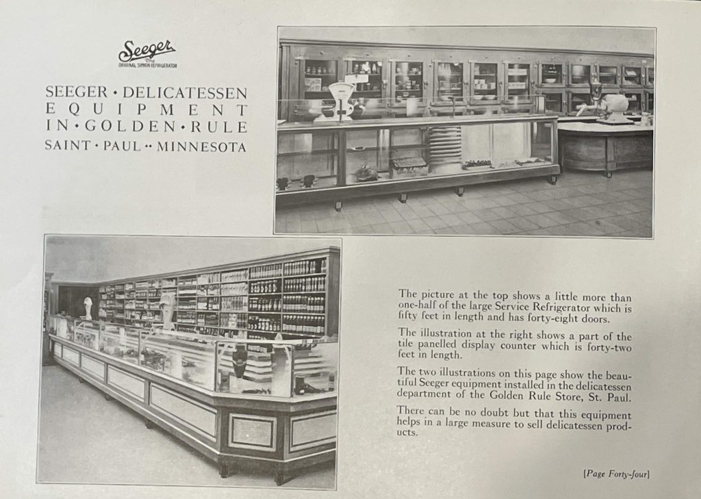
Seeger also made refrigeration equipment for professional kitchens and delis, including Saint Paul’s own Golden Rule Department Store. 
Like most factories, women at Seeger frequently took over traditionally male jobs on the production line during World War II. Minnesota Historical Society
The intersection and neighborhood began to change both physically and socioeconomically in the early ’60s. The relocation to Maplewood of 3M’s headquarters and many jobs was the first blow. The 1984 closing of the former Whirlpool/Seeger plant was another gut punch to the neighborhood. Within three years the empty Whirlpool buildings were taken down, replaced by the Seeger Square strip mall (below).

The loss of thousands of jobs from those big employers filtered down with the expected effect on many smaller businesses—restaurants, bars and stores—in the neighborhood and the entire East Side.

One Arcade Street industrial business that persevered is Northern Iron & Machine. The nearly two-block-long factory is a collection of structures built between 1913 and 1974.


Today Northern Iron & Machine employs about 77 people in its iron foundry and metallurgical lab.
Vestiges of 3M
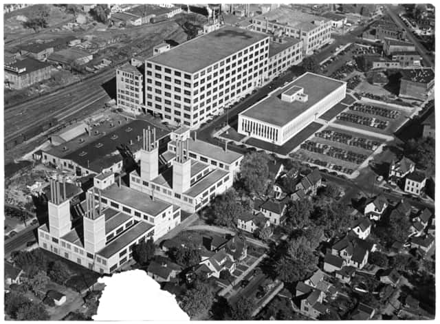
3M once had more than 40 buildings and thousands of scientists, production workers, support staff and executives on the East Side, on many blocks on either side of Forest Street and what is now Phalen Corridor.

(click map to enlarge)
3M moved its East Side corporate headquarters to Maplewood in 1962. Over the next 50 years, the remainder of its Dayton’s Bluff employees followed as 3M gradually closed the remaining East Side facilities. Still, bountiful reminders and artifacts are dispersed around the more than 45 acres of former 3M property. The most informative, and arguably most interesting, are interpretive panels featuring stories regarding the growth and development of 3M, its people, and its major products on St. Paul’s East Side.


Only one of the 3M buildings was spared from demolition after the St. Paul Port Authority’s 2008 purchase of the properties.


Undoubtedly the most important, the beloved Building 21 is now the main office of the Archdiocese of Saint Paul and Minneapolis. The Art Deco Building 21 served as 3M’s corporate headquarters from its 1939 construction until the 1962 move to Maplewood. It, too, was slated for the wrecking ball before extensive vocal opposition from neighbors and preservationists eventually forced the Port Authority to revise the plan.

While Building 21 has never been moved, it’s had three different addresses. When it opened, the building was located at 900 Fauquier Street, named for the Virginia county, according to Don Empson’s The Street Where You Live. In 1957 the St. Paul City Council renamed it Bush Street after 3M Chief Executive Archibald Bush. Finally, after the demolition of the other former 3M buildings in the 2010s, the removal of a block each of Reaney Avenue and Mendota Street, and the truncation of Bush Avenue, 900 Bush became 777 Forest Street.


One other piece of 3M history stands next to the Archdiocese headquarters. The 66 foot tall flagpole was installed at the corner of Bush Avenue and Mendota Street in September 1941.


Moving a block north as the crow flies, I got a different look at the building that replaced Seeger/Whirlpool.
Verticle Endeavors, an indoor “rock” climbing facility, opened at 855 Phalen Boulevard in about 1990. Nicros, adjacent to and owned by the same people, designs and manufactures climbing walls and related accessories. While not readily apparent, both businesses are actually in the lower level of the Seeger Square mall.


To paraphrase an old saying, things continue to change. Seeing parts of St. Paul that are or have changed drastically makes me wonder: what transformations will come in future decades?
Editor’s note: This article is reprinted from Wolfie Browender’s blog, Saint Paul by Bike: Every Block of Every Street. All photos by the author unless otherwise noted.