
Editor’s note: This is the first part of a three-part series covering the METRO Blue Line extension project. This part will cover the history, background, criticisms, hopes and future of the Blue Line. Part two will consist of land use issues currently faced in the corridor. Lastly, part three will cover conceptual proposals for Bus Rapid Transit and local bus routes in the northwest suburbs.
When North American cities build public transit, they often prioritize cost-effectiveness and commuter convenience over underserved communities, dense population centers and vital destinations.
It’s not too late to correct these mistakes for the METRO Blue Line extension. The Metropolitan Council and Hennepin County have laid out a timeline for the project, and there are plenty of challenges and milestones ahead, with a projected opening date at least six years away.
This timeline is approximate and is subject to change:
- Spring 2024: Ridership projections for this current alignment
- Early Summer 2024: Supplemental Draft Environmental Impact Statement Release
- Late Summer 2024: Municipal consent to confirm final route
- 2024: Cost estimate updated
- 2024-2025: Final design
- 2026-2027: Construction begins
- 2030: Extension opens for service
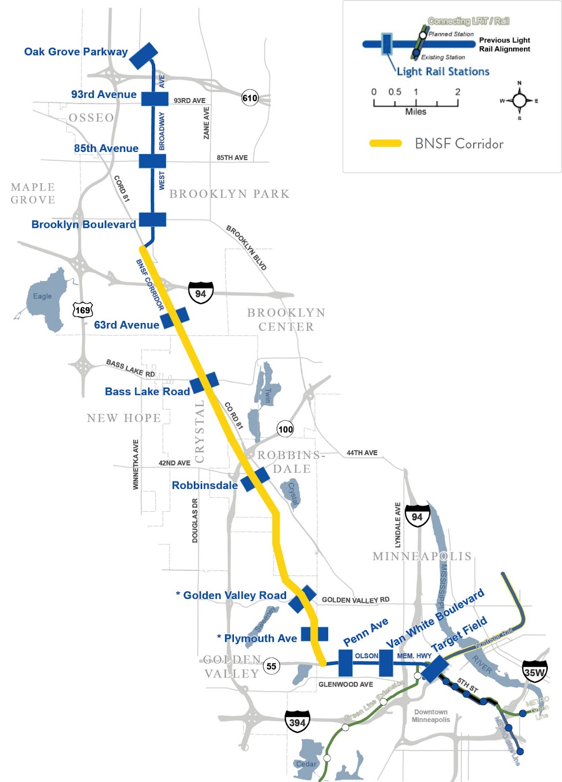
A lot can change in that time; a lot already has. In the early 2010s, the Blue Line extension plans had the line running alongside old Burlington Northern Santa Fe (BNSF) train tracks for roughly eight miles. The old alignment avoided population centers in north Minneapolis and most of the North Loop. Tracks partially ran on Highway 55 (Olson Memorial Highway) and retained the existing number of travel lanes, which divide neighborhoods and are unsafe. Plans to bring back 6th Avenue North, which Olson Memorial Highway replaced, are still many years away from reaching fruition.
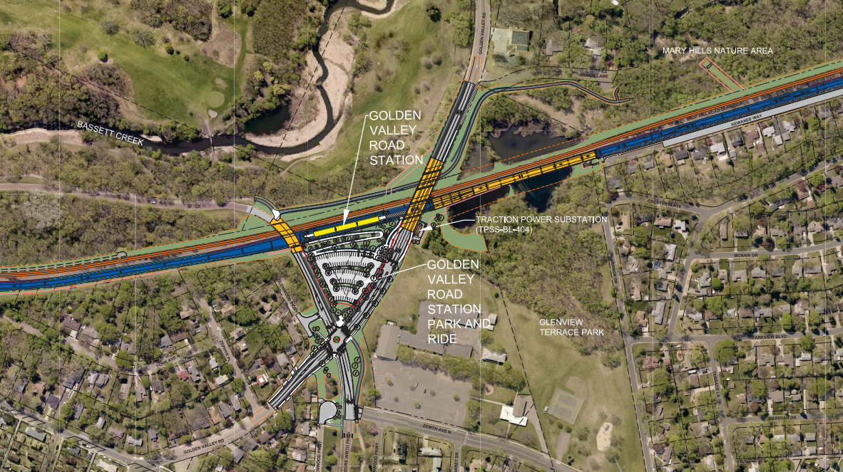
Stations in Golden Valley were tucked away and did not serve their neighborhoods well. The original alignment was heavily focused on bringing commuters from the suburbs to Minneapolis.
Everything was right on track in 2019, with plans to open in 2024, and ready to break ground until the project was completely derailed. After four years of attempted negotiations with the freight railroad, Hennepin County and the Metropolitan Council decided it was time to move away from the BNSF rail corridor.
The Blue Line as of Now
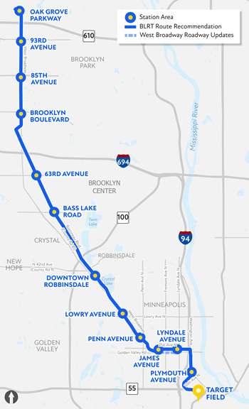
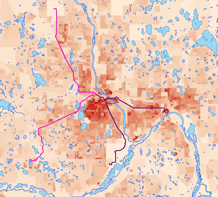
Today, the Met Council plans to extend the existing Blue Line northwest from downtown Minneapolis to travel through the North Loop, north Minneapolis, Robbinsdale and Crystal, terminating in Brooklyn Park. Twelve new stations are proposed, along approximately 13.4 miles of new track.
Cost estimates as of 2019 put the Blue Line extension project at $1.54 billion. That’s recently been updated; early cost projections as of February 2024 currently put the Blue Line extension project at $2.9 billion to $3.2 billion.
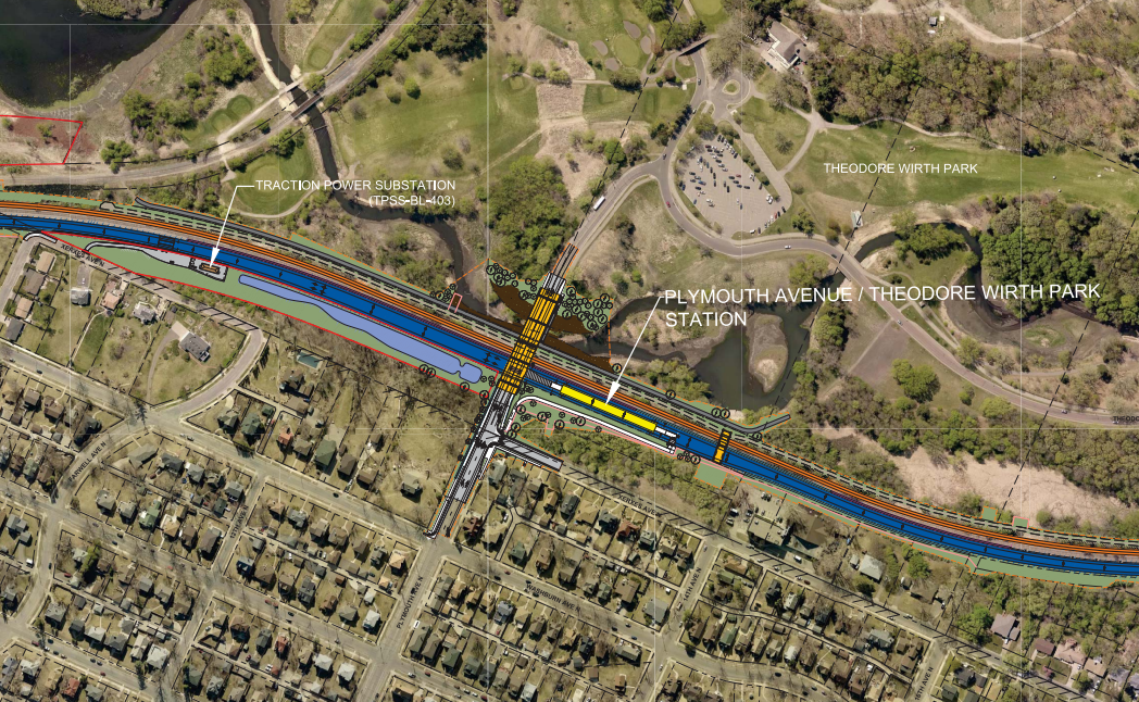
After negotiations broke down with BNSF, the Met Council made a route modification in 2021. The new route would run tracks to the heart of north Minneapolis through West Broadway. Several other options to put tracks elsewhere on the north side were discussed, but that debate is already long over.
Once the route was mostly settled, it was met with pushback from West Broadway businesses and residents, including the Blue Line Coalition, who took issue with the proposed line’s right-of-way (ROW) impediments. After further evaluations and feedback, a portion of the route on West Broadway was moved a block north to North 21st Avenue. That section of West Broadway will instead receive improvements once construction begins.
So I Can Get to Minneapolis, Right?
I’m a resident of the 55443 ZIP code, in Brooklyn Park. It’s nearly impossible to get anywhere from here in a reasonable time frame without a car. Nearly everything here has been designed and zoned to fit car-centric lifestyles, but that doesn’t mean driving should be the only option for more than 80,000 residents.
If I, or any of those residents, want to get to Minneapolis and beyond, I can take the 768 rush-hour only express bus. Outside of rush hour, however, I have to get on the 722, which arrives every 30 minutes at peak frequency, and more typically every hour.
The nearest 722 stop is at Brookdale Drive North and France Avenue North and takes about 20 minutes to get to the Brooklyn Center Transit Center. It’s about an hour’s walk or a 15-minute bike ride away, and that doesn’t account for the trip on the METRO C or D line.
Whether people live close or far from a bus stop, it can be impossible for many, including myself, to get to essentials such as childcare, appointments, groceries and work. Lengthy and inconvenient rides create barriers in our communities, no matter the income or access to cars. This is why we need the Blue Line extension. It’s more than just a light rail transit project, but a much needed investment in our communities.
North Minneapolis Alignment
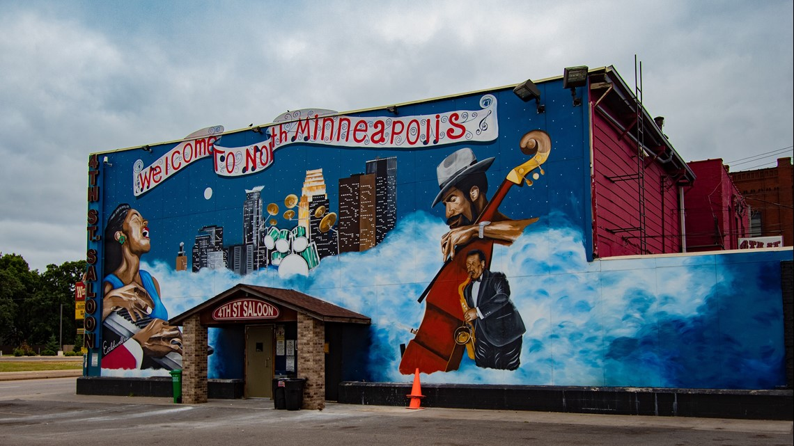
North Minneapolis has historically been redlined, racially segregated, disinvested in and so much more. The effects of these policies and practices exist to this day, and disinvestment in transit is one of them.
Before the route modifications, north side communities and the heavily Black suburbs of Brooklyn Park and Brooklyn Center wouldn’t necessarily have been served by light rail. It’s one of the most transit dependent neighborhoods, yet the Blue Line was going to skip over it and North Memorial Hospital.
Now, the Blue Line will better serve key destinations, communities of color and dense residences of north Minneapolis. This would not only improve equity and bridge disparities, but provide faster service to other areas of the metro. Nearly two-thirds of those 80,000 Brooklyn Park residents I mentioned are people of color; this project promises to improve transit options for them and the also POC-heavy communities of the north side and Brooklyn Center.
Some opponents have called this project “another Rondo,” referencing the decision in the 1960s to bisect St. Paul’s Rondo neighborhood with Interstate 94, bulldozing hundreds of Black homes and businesses and destroying many residents’ hard-won, short-lived generational wealth.
Although the Blue Line extension does not threaten to bulldoze entire city blocks, as I-94 did, displacement and gentrification are among the top concerns of residents, businesses and city officials as steam picks up for the project.
Along the corridor, the Met Council and cities should closely collaborate to expand housing options, control rent increases, provide reparations for displaced residents of the Harrison neighborhood (many of whom reported rising property values and land speculation when the route was still set to travel through the area), invest in community programs like universal basic income, small business grants or right-to-return programs, protect local businesses, and revitalize unused land and parking lots, ensuring that existing residents reap the benefits of the Blue Line.
North Loop Alignment
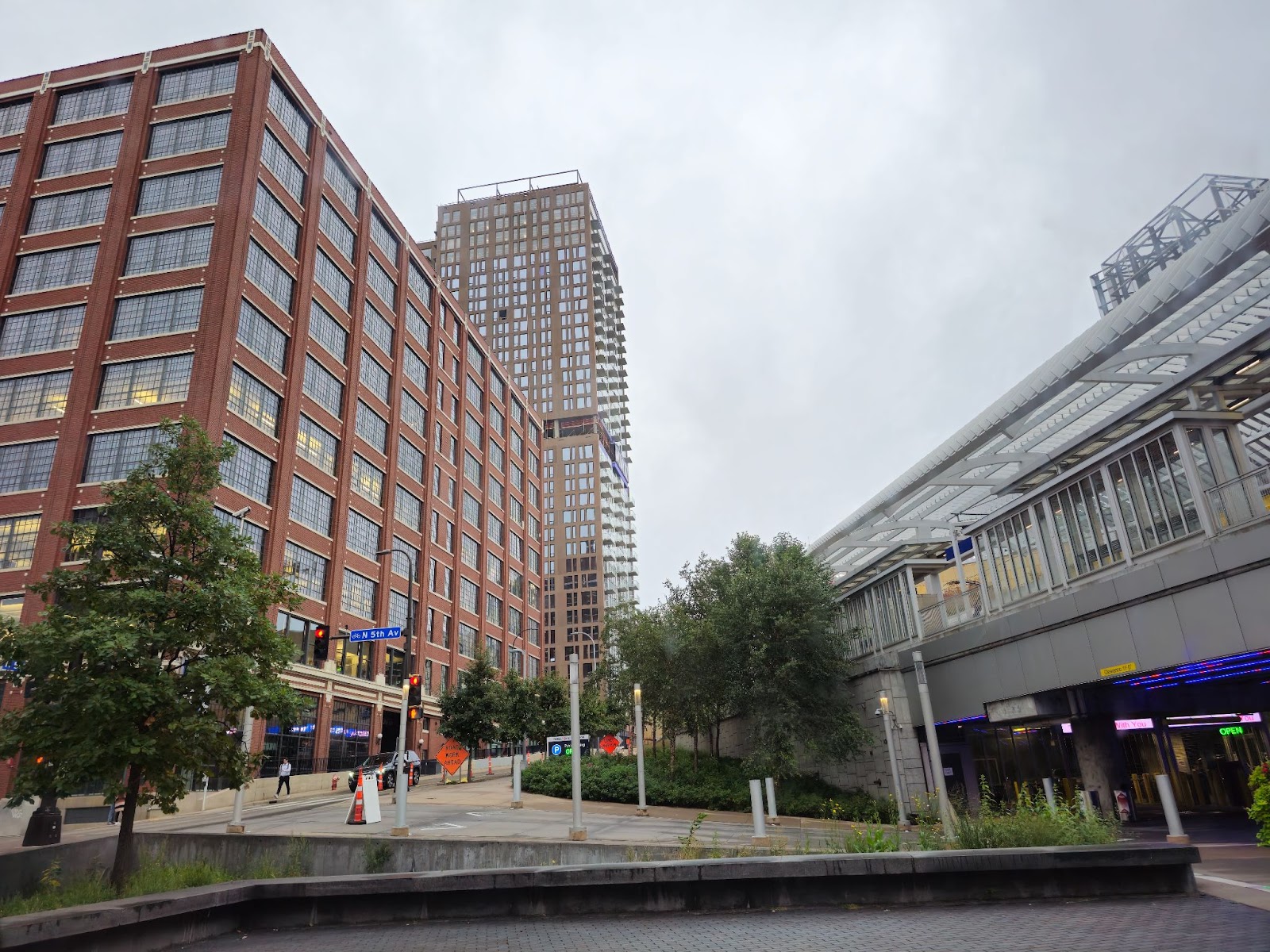
Two other great debates are ongoing for the Blue Line extension. One is over track alignment: Should the line proceed directly along 10th Avenue to Washington Avenue, or take a detour off of 10th to take 17th to Washington?
The second issue is whether a one-way travel lane will remain or 10th will become a transit mall. Personally, I would go for the transit mall option any day; it offers a much more pleasant place to wait for the train, patronize nearby businesses and simply exist in public.
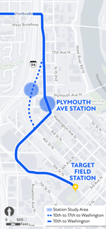

For example, South 5th Street in downtown Minneapolis is a little dull and isn’t really the place to walk around and enjoy time spent waiting for the train. Most of Southeast Washington Avenue at the University of Minnesota, meanwhile, is a transit mall and thus is more pleasant and safer for riders.
While free of cars, the transit mall option allows emergency vehicles and buses to use it. Even so, I almost always see cars barreling down the street when I pass that section of 10th.
View of North 10th Avenue, looking northeast
In November 2023, more than 600 people signed a change.org petition opposing the 10th to Washington route in favor of BRT on another route.
One signatory told KSTP: “…from our bedrooms, from our living rooms and listening to the trains and having people sit on a train and look into your bedroom window at 11 at night or 5:30 in the morning is an invasion of privacy.”
The noise problem is perhaps unavoidable, as trains have to sound their bells often for safety reasons, but the idea that a train would create substantially more noise than those barreling cars leaves me skeptical. It’s also interesting that people fear trains will “invade their privacy.” The North Loop has nearly 8,000 residents. Lots of people walk, ride buses and drive cars all around. The train, somehow, is a privacy problem, right near the heart of Minneapolis?
As stated in KSTP’s video interview, the interviewees support LRT in their neighborhood, just not on this route.
Anti-displacement initiatives are still working to ensure fair compensation, relocation, limited impacts and brand new opportunities. The Met Council and Hennepin County contracted with the University of Minnesota’s Center for Urban and Regional Affairs (CURA) in 2021 to convene a 26-member anti-displacement work group to ease concerns and reduce impacts on people and businesses in the project corridor.
The work group plans to reconvene soon to continue to reach out, guide the project, mitigate impacts and continue to support businesses and residents before, during and after construction. To learn more about anti-displacement efforts, visit here. To read a 14-page executive summary, visit here.
I conducted a brief survey of some Blue Line neighbors about some of their concerns and hopes for the line. Unfortunately, only one person responded; fortunately, that person was Ryan Borne, owner of Office Liquidators as well as its building, who provided some great perspective. Borne previously served on the Blue Line Business Advisory Committee, and his business is adjacent to future tracks on Bottineau Boulevard, near the Brooklyn Boulevard station.
Borne is a supporter of the Blue Line, and says he’s excited about the “increased economic atmosphere” it could bring to the northern suburbs and Brooklyn Park, ” “as well as accessibility for underserved transportation communities.”
Displacement concerns, Borne said, were a major part of Metro Transit’s communication with stakeholders along the line. “They were concerned about displacement largely as well as what route makes the most sense,” Borne said. “They could have been faster to come up with the plan though I know the process also slows everything down.”
While short-term impacts on businesses may be negative, Borne said, and he has concerns that the current alignment may not make stops accessible to more people, he has high hopes for the project’s longer-term impacts. “As a building and business owner I think the line will have a positive effect on property values and a short-term negative effect on retail sales because of construction,” he said. “Redevelopment of the area should encourage growth but it could be largely residential.”
Robbinsdale Streetcar and the history of North Metro transit
The Blue Line extension has a predecessor of sorts in the Robbinsdale streetcar system. It ran from downtown Minneapolis north to downtown Robbinsdale, near modern-day Highway 100.
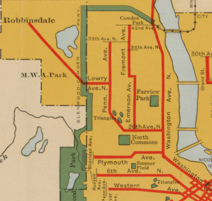
The Twin City Rapid Transit Company (TCRT) began service on the route on May 29, 1891 with three-cent fares, the equivalent of $1.01 today. Horses pulled the streetcar until it was electrified in 1898. The entire Twin Cities streetcar system carried over 200 million riders each year with over 524 miles of track.
When the automobile began to become more popular, streetcar lines started to disappear. Car manufacturers such as General Motors bought out systems across the country, including our own. Streetcars were then torn up and replaced with buses. New management took over the TCRT in 1949 and stuck with buses because they were cheaper to operate.
Corruption and organized crime could also be to blame for the rapid demise of the streetcar. The last streetcar in the Twin Cities system ran on June 19, 1954.
In 2030 when the Blue Line extension opens, the historic streetcar line will be over 139 years old. It will also be the first time trains serve the corridor in over 70 years. In that sense, the train promises to right a historical wrong by returning service that was stripped from an underserved area by corruption, graft and racist neglect.

Maximize Ridership, But How?

Let’s move on from the route-specific complaints and address some more general critiques, like frequency. Lord knows it’s tough to win people over to a train that doesn’t come regularly or on time, so how will the Blue Line Extension hold up on that front?
The frequency of transit is a core pillar to attracting riders. Headways (the time intervals between the arrivals of transit vehicles) on both the Blue and Green lines should therefore be targeted for at least every eight to 10 minutes rather than the current 15 to 20 minutes. 24/7 service should also return with a slightly lower frequency during overnight hours.
Transit signal priority (TSP) improves speed and reliability of buses and trains by extending the green light ensuring they clear intersections in time. This will likely also be used on the BLRT. As there are fewer signals in this corridor, it’s less likely a train will be caught up in a light.
Speed is a more obvious issue. if the trains aren’t fast enough, it may disincentivize their use. The section south of Lowry Avenue station may be a little slower as it conflicts with vehicles more and makes sharper turns, but at most this will add a minute or two.
Note: Long-lasting effects from the pandemic and driver shortages are currently among the top reasons for reduced services. Metro Transit is expected to increase frequencies on both LRT lines in the summer of this year.
How About BRT Instead?
I’ve heard a few people and advocacy groups calling for bus rapid transit (BRT) rather than light rail in this corridor.

Don’t get me wrong, I love buses, the faster the better, but the needs of this region are immense, and a BRT alternative to the Blue Line extension would not be enough to meet north metro communities’ needs in the long run.
Connections with major destinations, businesses and residences would diminish. BRT is mixed with traffic, has less capacity, less reliability, draws in fewer riders and travels more slowly than trains.
We could also run the BRT along a transitway and outfit it with features from light-rail transit (LRT). At that point, we might as well use that money for light rail instead.
While BRT is generally cheaper up front, maintenance and operating costs can make LRT a better use of each dollar. This is because scaled up BRT service means more drivers, more buses and more fuel consumption whether electric or diesel.
Light rail also tends to bring in far more economic development and investments while luring in more riders than a bus ever would, not to mention ridership capacity. The D Line BRT runs on a similar route to the Blue Line’s, from the Brooklyn Center Transit Center to the Mall of America. But it has less than half ( under 14,000) of the current Blue Line ridership, which is roughly 20,000 weekday rides (November 2023)— despite covering 18 miles to the Blue Line’s 12.
Opposition group Stop Light Rail on 81 (SLR81) says there are alternatives. But that begs the question: What do the alternatives look like and where do the alternatives go? After all, the D line already covers the same territory, but isn’t meeting the needs. I can give them credit for bringing up issues like the first-mile, last-mile problem, but there’s a lot missing from their arguments.
Among these are climate issues. Minnesota is well known for its extreme weather. So, whether we have snow, blizzards, rain or thunderstorms — weather that disrupts other modes of transportation — LRT is one of the most resilient, safe and reliable forms of travel.
When it comes to the climate crisis, this is one of the cleanest ways to get around, as LRT is fully electric. It also cuts down on car-dependency, which reduces traffic, CO2 emissions, noise pollution and more. BRT just doesn’t measure up in the same way.
Public Safety
Objections to transit projects, and particularly Metro Transit’s light rail extension projects, often include some variation on “the train will bring crime into our neighborhoods.” Putting aside for a moment the dog whistles in those critiques, there’s no question that in recent years, light rail riders have encountered quality-of-life and public safety issues with more frequency than they did before the pandemic.
Unlike some policymakers, I highly doubt turnstiles and enclosing street-level LRT stations are the solution. Even so, Metro Transit is already taking some steps to address those issues.
Initiatives like the Safety & Security Action Plan enacted in 2022 focuses on enforcement, enhanced presence, community outreach, and other measures that are proving to be effective.
From the enacted action plan, Metro Transit has updated their Code of Conduct, added new signage, made reporting issues easier, increased initiatives to hire more Community Service Officers (CSO), are issuing administrative citations for fare non-payments and other efforts.
Listening sessions were also conducted in January of this year with Metro Transit leaders to hear from riders on the system.
In an interview, Metro Transit Police Chief Ernest Morales III says he’s aware, wants to be honest with what we’re seeing out there, and is continuing to get on top of more enforcement. Even more measures to improve the experience and safety of riders are in the works despite staffing shortages. Whether or not one agrees with Metro Transit’s approach, it can’t be argued that public-safety arguments against the Blue Line haven’t been heard and addressed.
Develop and Connect
View of the under construction Tessman Ridge apartments, near the future 85th Ave station, looking northwest. Does not reflect current progress.
Transit-oriented development (TOD) is an urban planning concept in which mixed-use and compact development is encouraged within walking distance of major transit stops. Some of this is already in the works along the proposed extension, and suburban cities appear willing to build these types of developments. In Brooklyn Park, for example, the 71-unit Tessman Ridge apartments under construction near the future 85th Avenue station will house both market-rate and affordable units.
Connectivity is important when bringing riders to stations. Some proposed stations are currently almost completely inaccessible by bus and difficult to reach+ by bike or on foot especially for those who live farther away. More investment in traffic calming, bike infrastructure and comfortable wide streetscapes are a must.
Learning Lessons from the Green Line Extension
The Green Line extension (also known as Southwest Light Rail or SWLRT) project has been a long, beleaguered process. Some are concerned that the same issues facing it will also be seen on the Blue Line extension.
Engineering changes such as a new crash wall, adding in another station that was previously removed from the project, 2,544 construction changes, or an impediment in the Kenilworth corridor and tunnel are just a few examples of SWLRT’s woes. .
Other issues include a 2014 lawsuit seeking to stop the project, backed by “wealthy communities not supportive of the project with little tolerance for the impacts arising from construction,” according to Lunda McCrossan Joint Venture (LMJV), the contractor for SWLRT.
LMJV says engineering designs were “incomplete, erroneous and inadequate” when they were given the job to construct SWLRT.
The project will likely cost $2.86 billion over its projected $2.003 billion, and is over 75% complete. The service will open in 2027.
Despite its issues, the Green Line extension is still a vital artery for connecting the southwest metro area. The Blue Line extension will not have any tunnels, making the biggest issue with the Green Line’s extension irrelevant. I’m hopeful that the Met Council will continue to make their wrongs right with this extension, and so far that’s seemed a reasonable hope.
Empower Communities
Another public investment like the Blue Line extension will never come again, so let’s make it work for the people.
Construction disruption will be an issue in the short term. Business needs should be met while work goes underway. In the long term, however, the short headache will provide greater achievements for a better integrated Twin Cities.
Not only does it connect with one of the most transit-dependent neighborhoods, it brings equity, sustainability, faster services, investment and brand new opportunities for the northwest metro.