
First: no one involved in the accident – neither I, nor the driver or their passenger – was injured in the accident. However, even though I was hit by a car, something much worse could have happened.
This incident prompted me to examine the crossing at East River Parkway and Washington Avenue in Minneapolis more closely through the lens of my cycling accident on Sunday, November 17, 2024.
The Incident
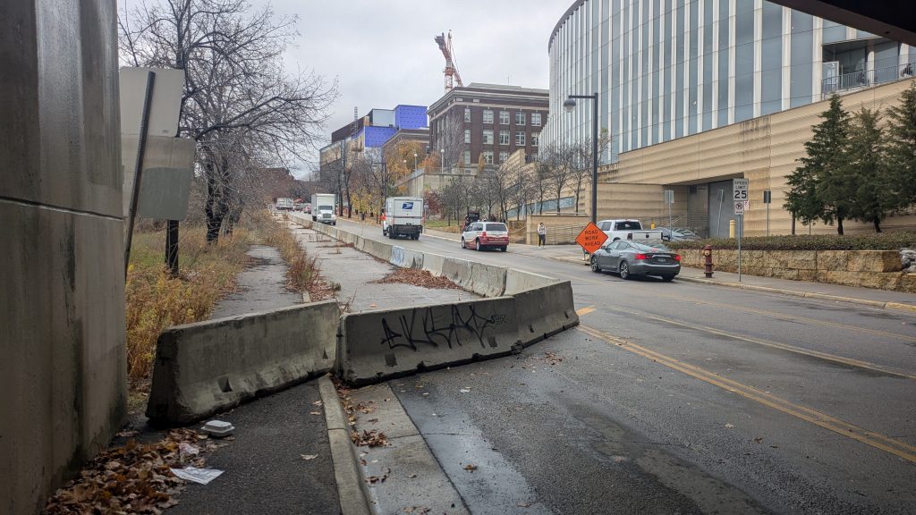
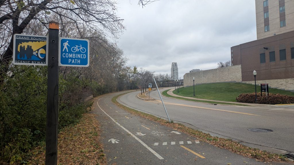
My wife, Cassandra, and I were biking to a pop-up market in St. Anthony Main on a sunny Sunday afternoon. Our most direct route involved cycling north on the two-way bikeway along East River Parkway to the Dinkytown Greenway. This path, however, abruptly ends beneath the Washington Avenue bridge. Despite regularly cycling past this closure, I always feel uneasy navigating the transition from the protected bikeway into car traffic.
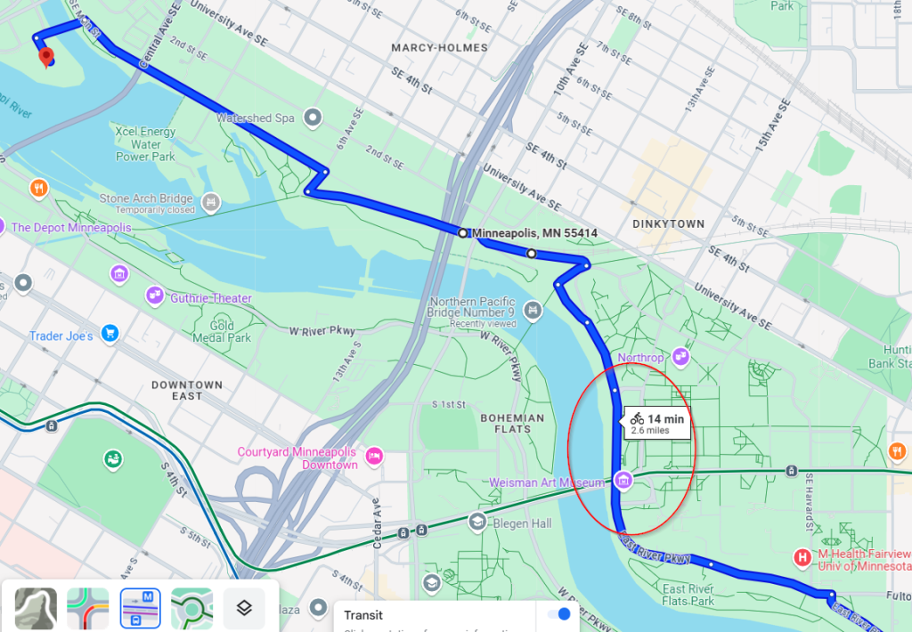
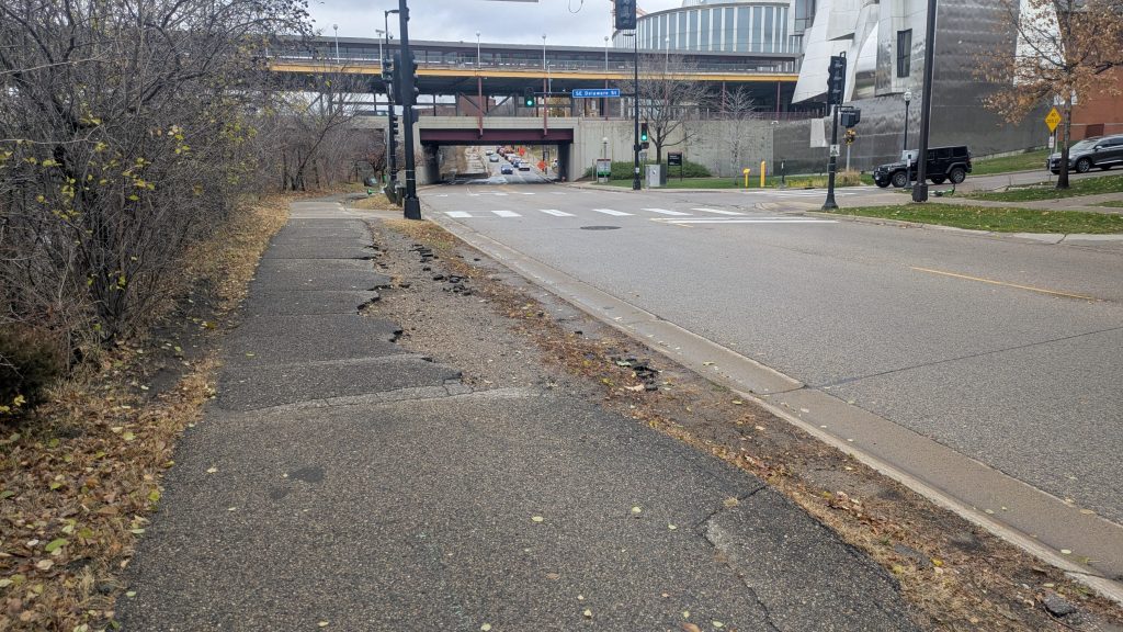
On that day, my wife and I stopped at the crosswalk on the south side of the Delaware Street and East River Parkway intersection. As the crosswalk signal changed to “walk,” I noticed the driver of a red sedan glance in my direction. Assuming they saw me, I pushed forward into the intersection.
In a split second, I saw the vehicle turn left toward me as my wife yelled, “Raj, watch out,” but I froze. Before I could think of what to do, the car slammed into me, knocking my bike out from underneath while I bounced across the car’s hood, ultimately landing on the pavement beside it.
Thankfully, I escaped with only minor bruises. The driver, equally shaken, stopped immediately and we exchanged information. I’m lucky the outcome wasn’t worse; their car was small and moving slowly, and I was raised slightly higher by standing on my pedals. However, my bike had less luck than me. The frame was scraped, the handlebars were misaligned, and the front tire was bent to the point of rubbing the brake pads. I’m sure it looked funny, but I was able to bike home after disengaging the front brake. Despite the lack of physical injury, the incident lingered in my mind. What happened?
Examining the Intersection
The following day, I returned to inspect the intersection and took note of several factors that contribute to its dangers for cyclists and pedestrians:
Vehicle-to-Pedestrian Ratio
This intersection sees heavy vehicle traffic because of restrictions on private cars along Washington Avenue between Church and Walnut streets. This restriction keeps Washington Avenue pedestrian-friendly in the heart of the University of Minnesota’s campus, but forces diverted traffic through this intersection. Meanwhile, cycling and pedestrian traffic is relatively sparse considering the university buildings all face east, thus there are no local destinations on this stretch of East River Parkway. These characteristics create a high vehicle-to-pedestrian ratio that makes non-vehicular road users less visible to drivers.
T-Intersection Design
Given that this is a T-intersection, vehicles turning left from Delaware Street onto East River Parkway don’t encounter oncoming vehicle traffic. This can give drivers a false sense of freedom, given that the only other party that could have a right of way would be a pedestrian in the crosswalk.
Signals and Signage
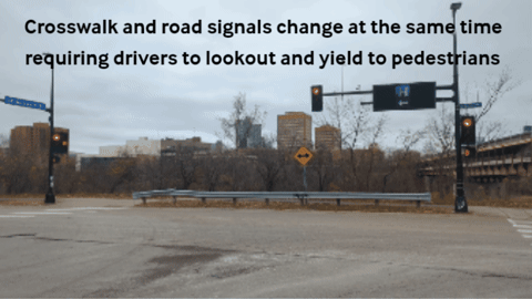
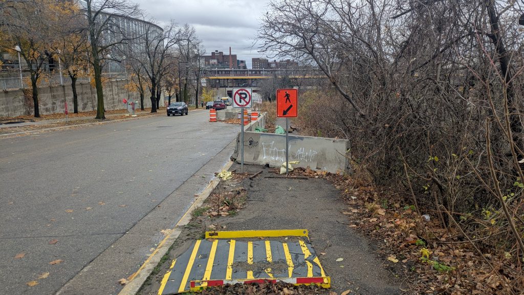
No signs inform cyclists of the path closure or explain how to merge with traffic. Similarly, there are no signs cautioning drivers about crossing cyclists. While the intersection includes standard traffic signals and pedestrian crossing signals, it does not have added safety features like leading green arrows or leading pedestrian intervals on the crosswalk signals. Not unlike other intersections, crosswalks change to “walk” the same moment traffic signals change to “go.”
Road Paint and Layout
The road paint is that of a standard intersection without bike lanes: zebra-striped crosswalk on each street but no green paint to direct cyclists and drivers. Additionally, the raised sidewalk-grade bike lane affords cyclists few opportunities to merge with traffic south of this intersection. Lastly, the street has both curves and hills, forcing cyclists to merge at awkward angles and leading to a significant speed gap between cyclists and vehicles. If the street is clear, I often merge onto the vehicle lanes early, but I feel both guilty and unsafe if traffic does build up around me.
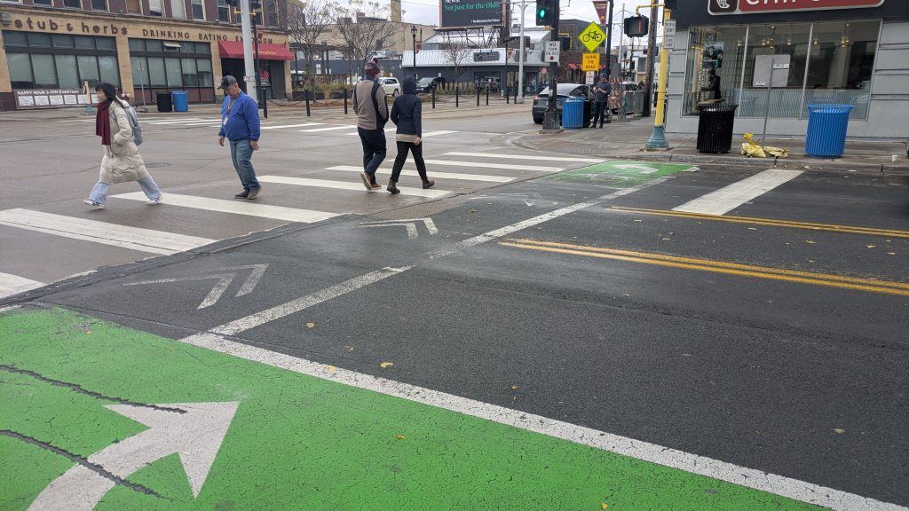
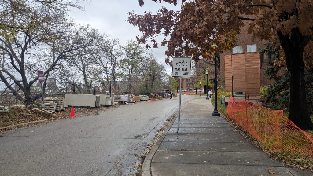
Compare: Oak and Washington Intersection
I also frequently bike through the Oak Street and Washington Avenue intersection where a two-way bike lane ends abruptly. However, that corridor is much safer.
Here’s why:
- Cars turning left can only turn on a green arrow, preventing conflict with crossing pedestrians.
- Clear road paint and signage effectively directs cyclists while cautioning drivers.
- Additionally, the area’s dense multi-modal traffic combined with narrow streets keeps drivers more alert. I’ll be happy when this intersection is updated in spring 2025, but until then I feel at least moderately safe as I merge with car traffic.
Lessons Learned From a New Bicyclist
I’ve biked in urban areas for many years, but a bike only became my primary means of transportation five months ago when I moved to Minneapolis from Chicago. Reflecting on this experience, I realized some important lessons:
- Cycling isn’t walking: Bikes lack the agility of pedestrians. I should have been more cautious about entering the crosswalk even though I had the right of way.
- Your voice has power: When on a bike your voice is the best emergency tool you have. In this instance, yelling could have prevented an accident.
- Prioritize safety over speed: There was a build-up of Lime scooter riders parked at the north crosswalk, perhaps also determining how to navigate the closure. I often use that crosswalk since one lane of traffic is stopped, but in the interest of time I chose the south crosswalk. I won’t make this mistake again.
Intersection History
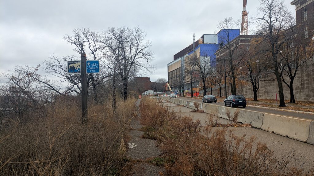
The Minneapolis Park and Recreation Board (MPRB) maintains the parkway, which is part of the Grand Rounds Scenic Byway. The closure stems from a slope failure that heavy rains caused in July 2019. East River Parkway was closed to vehicle traffic at this time as well. The northbound lane opened five days after the incident. The southbound lane opened 23 days after the incident. As of this post, however, the path remains closed for 1,953 days and counting.
MPRB’s last update on this closure was June 9, 2020, and at the time of my accident, their project overview page indicated that the trail would be re-opened during the first three months of 2024. When I reached out to MPRB, they immediately replied, apologizing for the outdated website and noting that the project had stalled due to costs and complexity.
My Recommendations for the Corridor
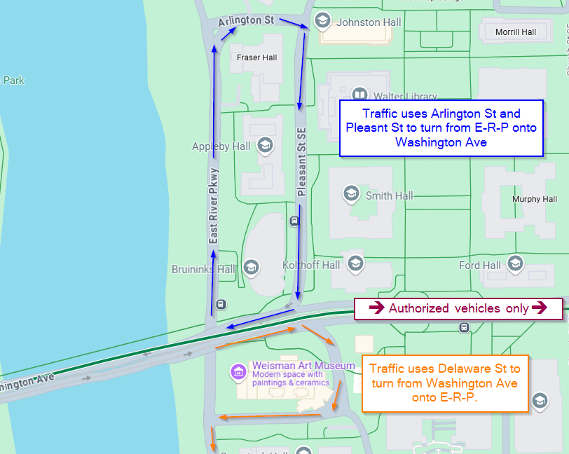
East River Parkway is a unique street given that the Park Board, the University of Minnesota, Hennepin County and the City of Minneapolis all have a stake in the roadway. I acknowledge that oversight by multiple jurisdictions adds complexities to infrastructure projects. Furthermore, it’s plain to see that the street resides on a bluff yielding topological considerations. Nonetheless, the communities around the University of Minnesota and East River Parkway should have a safer corridor to Northern Pacific Bridge Number 9 and the Dinkytown Greenway. This bridge is one of the few bike-safe river crossings and is the most direct route to business and entertainment in Downtown Minneapolis.
I would like to see the trail rebuilt at least to its prior terminus north of Arlington Street, shielding pedestrians from high vehicle traffic. Going a step further, the community and the university would benefit by extending the byway north by one block, providing an uninterrupted connection between East River Parkway and the Dinkytown Greenway. Notably, this gives residents and students safer biking and walking access to their largest nearby business district.
At minimum, I believe the agencies overseeing this intersection should implement interim solutions such as enhanced signage and road paint, leading pedestrian intervals or green arrow traffic lights. In an email exchange, City of Minneapolis Pedestrian and Bicycle Coordinator, Alex Schieferdecker, acknowledged that while the intersection is signalized and painted, there may be opportunities to better indicate the presence of bicyclists.
This experience underscores the need for safe bicycling and pedestrian infrastructure. While frustrating, the situation has left me optimistic that Minneapolis, a city with a strong reputation for supporting cyclists, will address these issues. In the coming months, I hope to better understand why this MPRB project stalled and be an advocate for its reprioritization.
Additional Photos
All photos and images are by Raj Singh.