The author works in the building construction industry in Minneapolis. While urban planning is not his area of professional expertise, as a resident of Minneapolis he takes personal interest in exploring ways to improve transportation for all users of city streets. His views are his own and do not represent the opinions of his employer.
If you’re inclined to dismiss the term “modal filter” as esoteric civil engineering technical jargon, hear me out: This is one of the most important pieces of urban infrastructure in a planner’s toolbox. When used correctly, modal filters allow communities to build a transportation system that’s better for all users. Whether you’re biking, walking, or yes— even driving — you should want more modal filters.
What is a modal filter?
The term “modal filter” refers to infrastructure that allows certain methods of transportation to pass through while restricting others. As its name implies, a modal filter is something that filters for different modes of transportation.
In the Twin Cities, nearly all streets are through streets for motor vehicles. On any given route, drivers can pass all the way through a neighborhood without turns or delays. The result is that a large amount of vehicular traffic consists of trips that don’t start or end in that neighborhood—drivers are merely passing through to another destination.
On major arterial roads, this isn’t a problem. But minor side streets should serve a different purpose. These streets should prioritize users who have destinations on the street, rather than catering to drivers who are just using it as a shortcut.

Modal filters alleviate this problem by restricting vehicular traffic while permitting other modes of transportation. This results in streets that are quieter, safer, and more friendly to anyone outside of a car.
For those interested in human-centered city design, this is probably not new information. But there remains a very real question about how this infrastructure could negatively affect drivers. This is something planners must consider when making decisions, and it’s part of why modal filters are so important.
Designing for everyone means designing for drivers
When a new street design is proposed that deprioritizes vehicle use, a familiar set of arguments often emerges from opponents:
- This would restrict access for emergency vehicles.
- This would restrict access for delivery vehicles.
- This would make the street less accessible for elderly or disabled people.
- The loss of parking would be harmful to businesses and residents.
I’m a strong advocate for active transportation, but even I will admit this: the Twin Cities metro is, and will be for the foreseeable future, a car-dominated place. While city planners are making an honest effort to encourage alternatives to driving, the truth remains that most residents own cars and drive most places. Loss of parking is a real concern for businesses. Emergency vehicle access is a real concern for residents. As advocates, our job is not to shout people down when they voice these concerns, but to work with them to come to solutions that make streets safer and more hospitable to active transportation while acknowledging the fact that we will always have to design with motor vehicles in mind.
This is where the modal filter truly shines. By discouraging vehicle movement while still maintaining full access to the street, the modal filter achieves a compromise that all parties can get behind. Deliveries can still be made. Police and firefighters can still reach properties. Elderly and disabled people are not excluded. Parking can be maintained for residents and customers. At the same time, the lack of through traffic results in a street that is quieter for residents, safer for users, and generally more welcoming to anyone who isn’t driving.
This is not a new concept. The Twin Cities already feature a number of modal filters that serve as case studies for the effectiveness of this strategy. Let’s take a look at three examples.
Three existing modal filters
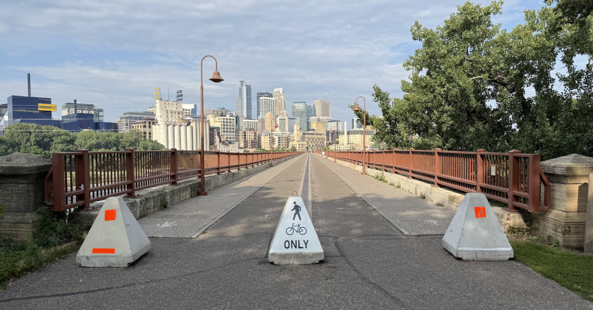
Midtown Greenway & 29th Avenue South
Located in the Seward neighborhood of Minneapolis, this is the quintessential modal filter: a barrier in the center of the street allows pedestrians and cyclists to pass but impedes vehicle traffic, resulting in a calmer and more pleasant street for all users.
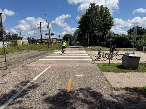
This modal filter happens to coincide with the eastern leg of the Midtown Greenway bike path, making it a logical spot to prioritize bike traffic. 29th Avenue is a redundant through street, and drivers can easily access the rest of the neighborhood using neighboring 27th or 30th avenues.
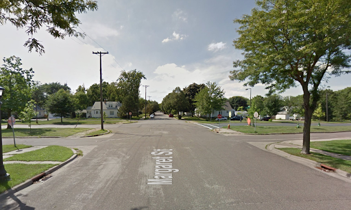
Como neighborhood grid
Visitors to the Como neighborhood in Minneapolis will be familiar with the following sight: a residential street that suddenly turns at a ninety degree angle, despite the street continuing just the other side of a curb and landscaping.
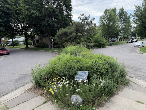
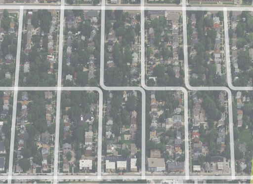
The streets of Como are intentionally laid out to provide vehicular access to all locations while limiting through routes, discouraging dangerous driving. If one wishes to drive from Como Avenue to East Hennepin Avenue, it’s possible to take 15th Avenue Southeast, take a 90 degree left turn onto Talmage Avenue, drive one block, take a 90 degree right turn onto 14th Avenue, and continue to East Hennepin, but it’s far easier to take 18th Avenue Southeast, the designated through street. As a result, car volume on 14th and 15th avenues is low, and most drivers on these streets are only here because they have destinations on the street.
Johnson Parkway in St. Paul
The Twin Cities have no shortage of historic parkways that are perfect for a leisurely drive, ride or stroll. Johnson Parkway in St. Paul received a facelift in 2020, adding a two-way protected bike path along with modal filters to limit through traffic on side streets.

Johnson Parkway isn’t alone: Honorable mentions with similar modal filters include Minnehaha and Victory Memorial parkways in Minneapolis.
The 2022 Johnson reconstruction is also a great example of a time when the city of St. Paul made a conscious decision to alter traffic patterns to improve safety and encourage active mobility. Why stop there? There are plenty of streets throughout the Twin Cities that could benefit from modal filters. Let’s take a look at three examples.
Three proposed modal filters
St. Anthony Main
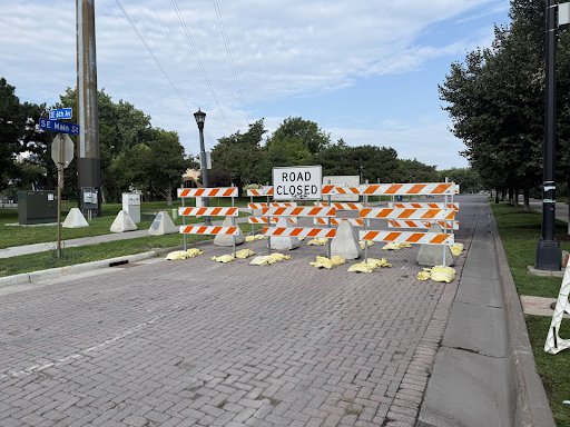
One of Minneapolis’ most picturesque streets, Southeast Main Street between Hennepin and Sixth avenues is a prime destination for many different types of users. On a typical weekday evening, you’ll find a mixture of visitors enjoying the view from the Stone Arch Bridge, couples taking engagement photos, locals enjoying a movie at The Main Cinema or a drink at Aster Cafe, and cyclists traveling along the river. St. Anthony Main is the very definition of a place that should be a destination and not a through route.
The city recognizes this, and for the past few summers, they’ve experimented with installing temporary barriers that restrict vehicle access from Sixth Avenue to Main Street. Signs clearly indicate that streets are open to vehicular traffic for parking and local access only. As a result, vehicular traffic is decreased, and there is much more room for the heavy foot traffic that this area regularly sees.
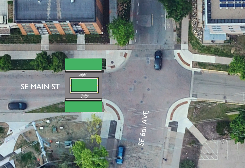
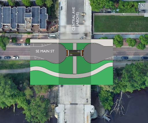
I propose making the modal filter at Sixth Avenue permanent and adding another on Main Street underneath the Central Avenue bridge. At this location, the street could be widened to allow local traffic to turn around. Vehicular access to facilities owned by Xcel Energy and the St. Anthony Falls Laboratory would be preserved, as well as accommodations for elderly or disabled users. The city has successfully tested this with temporary barriers, and it’s time to make this a long-term feature of the neighborhood.
Bryant Avenue
Much has been written about the state of Bryant Avenue South between Franklin Avenue and Lake Street. I don’t wish to relitigate this discussion, but for those unfamiliar with the story, I will offer a brief summary. This seven-block stretch of residential street in South Minneapolis is a key cycling connection between the Midtown Greenway and downtown. If you live, work, or have friends in Uptown, Lowry Hill East, Loring Park, or downtown, and you wish to bike between these destinations, Bryant will be a key part of your route.
Despite being designated as a “bike boulevard,” Bryant is effectively no different than any through street in the neighborhood, save for some painted bike symbols, fancy road signs, and the occasional speed bump. The built environment surrounding Bryant is urban enough to have high residential density, but old enough to have limited off-street parking, so the street is almost always full of parked cars (especially as you get closer to Uptown). Drivers can also use Bryant to travel between Lake and Franklin, so it’s often used as a through route, and cyclists must contend with traffic in multiple directions squeezing between rows of parked cars.
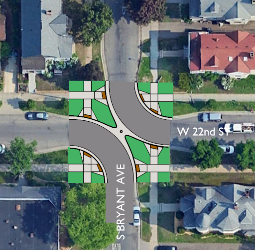
Previous efforts to make Bryant more cycling-friendly have failed in no small part due to the need for resident parking. This is where modal filters come in: By limiting vehicular access to the street while allowing parking, Bryant can become a true bicycle boulevard while still serving local residents who own cars. The city could achieve this by using the same strategy as the Como neighborhood. I propose breaking up the street grid and creating 90-degree turns at 22nd, 25th, 27th, and 29th streets to discourage through traffic.
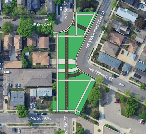
Fifth Street Northeast/Southeast
Passing through the Minneapolis neighborhoods of Dinkytown, Marcy-Holmes, and St. Anthony, Fifth Street Northeast/Southeast finds itself in unpleasant company with Bryant Avenue as a bike boulevard that lacks the infrastructure to truly make it a preferred route for cyclists. This is the primary cycling route between The University of Minnesota and Northeast Minneapolis, two urban neighborhoods with high demand for non-vehicular trips.
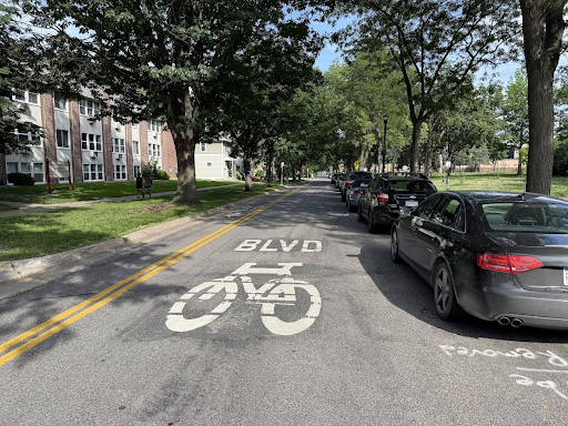
Strategically placed modal filters at Sixth and Fourth avenues Southeast, First Avenue Northeast, and Fourth Avenue Northeast would greatly improve this street.
The confusing intersection of Fifth, Washington, and Spring streets Northeast could also be reconfigured to prioritize bike and pedestrian traffic, which would especially benefit students at nearby Webster Elementary.
Where do we go from here?
If you’ve read this far, you’ve probably started thinking about how the ideas discussed in this article apply to your own neighborhood. Are there any modal filters you already use? Are there residential side streets where drivers are always speeding? Are there intersections that are routinely problematic?
This is my challenge for you: Start talking to your friends and neighbors about transportation infrastructure. In my experience, most people like to complain about roads and traffic, but they don’t think very deeply about the types of decisions that lead to our present built environment. Find examples of infrastructure done right, and use that as a starting point to discuss places that could use improvement. These are the types of conversations that allow us to build better places to live, work, and play.
All photos by the author, except where noted.