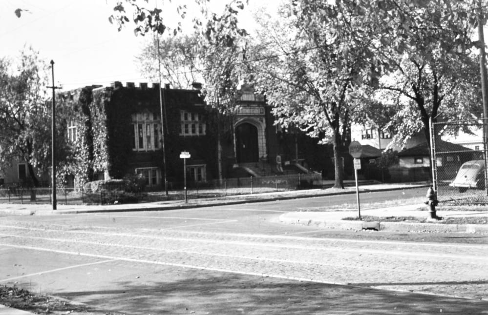
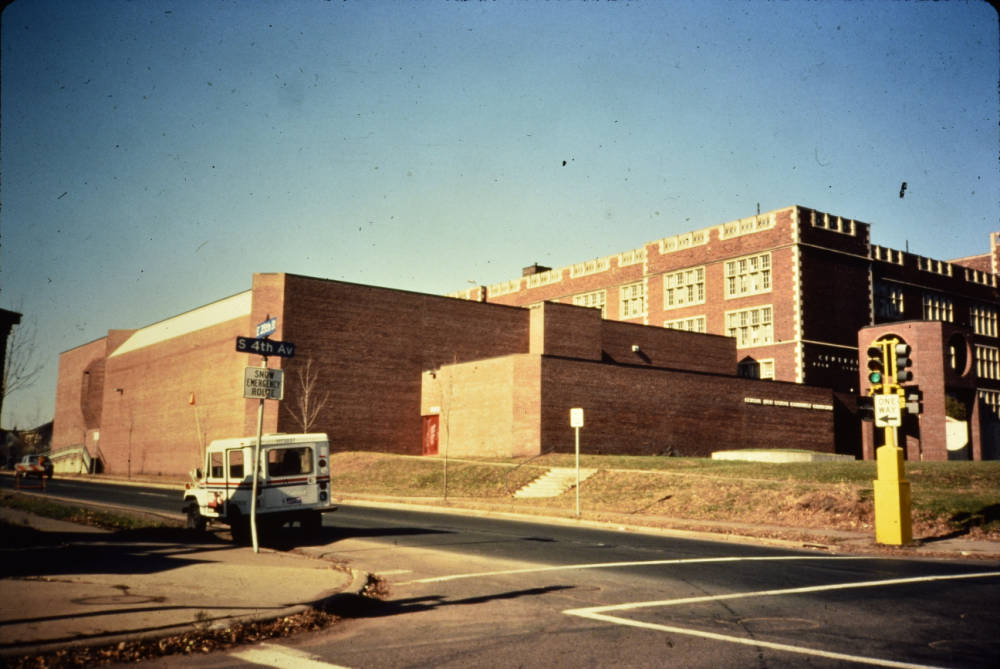
Top image: Hosmer Library at the Intersection of E 36th Street and 4th Ave South, 1940s. From the Department of Community Planning and Economic Development Records, Hennepin County Library.
Imagine it is the spring of 1951, a weekday afternoon in May. You are nine years old, and you just got let out of Warrington Elementary School at 37th St. and 3rd Ave. for the day. It has been a strange school year, with the school strike and everything. You sniff the air outside, the smell of bread from the bakery lingering in the air. Your sister is still in class at Bryant Junior High, just next door to Warrington, so you decide to walk up the block to Hosmer Library with your best friend. Maybe Miss Welles will play the new phonograph if you are VERY well-behaved? You find your favorite chair — a big, deep, leather chair with an irresistible bounce. The phonograph is NOT played. You are shooed out of the library, but not before doing a few headstands on the front steps with the library “lions” on your way out. You and your friend race across 36th Street to see if you can find your older brothers at the Central High School athletics fields. Coach Markley says they’re not there. Should you run over to Nicollet Park or go up to Nicollet Ball Field to catch the Millers game? You heard that new ball player who’s staying near the library is pretty good.
This is the sort of story that I hear over and over (with some variation) at the public library where I work, at the southwest corner of 4th Ave. S and East 36th St. At least once a month, someone, usually an African American elder, will walk up the stairs into the main lobby, pause, and look around. They will come up to the service desk, and say, “I haven’t been here in YEARS, but I grew up at this library, in this neighborhood.” If the library isn’t too busy and I’m very lucky, they will tell me the rest of the story: of how they attended one of the three since closed schools, or how their auntie owned a store nearby, or visiting their grandma down the block, or getting into trouble at Nicollet Park (now Martin Luther King Jr Park).
As part of the larger series on the planned reconstruction of East 35th and 36th Streets between Nicollet and Chicago Avenues in South Minneapolis, I volunteered to write about the history of this portion of the streets themselves. I started out wondering how I could tell the history of a short section of a pair of cross streets without many businesses or famous landmarks. I came back with a story of a community that was shaped, like all communities, by public infrastructure and policy, and then suddenly split and forced to reshape when that infrastructure and policy shifted. The story of this part of 35th and 36th Streets are small pieces of a larger history of Minneapolis: redlining, restrictive covenants, freeway construction, urban renewal, and segregation.
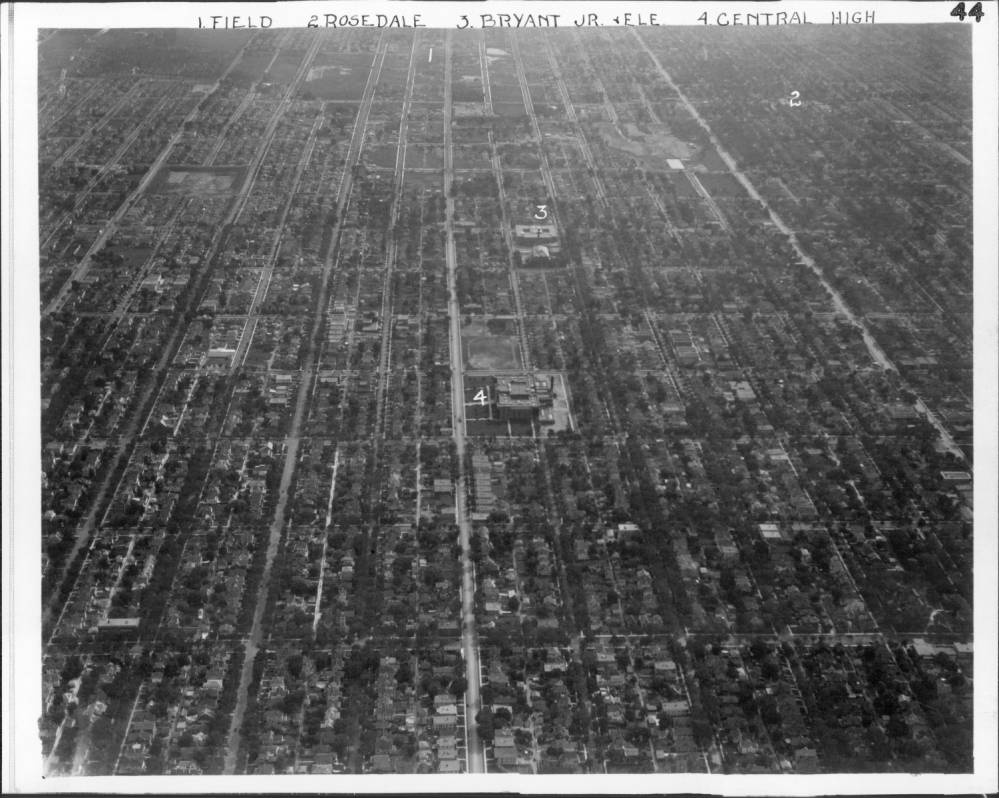
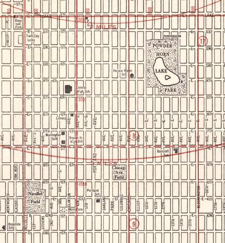
The stretch of 35th and 36th Streets that is being reconstructed once traveled through a rich community campus of learning, with Bryant Junior High, Warrington Elementary, Hosmer Branch Library, and Central High School spreading along 3rd and 4th Avenues from 38th to 34th Streets. They created the backbone of the Old Southside African American community, which was roughly bounded by Chicago and Nicollet Avenues on the east and west, and between East 34th and 46th Streets from north to south. This was a thriving middle class mixed-race neighborhood from the 1930s to 1970s, until combined pressures of highway construction, increased segregation and “white flight,” and the closure of area schools altered the community in ways it is continuing to grapple with today.
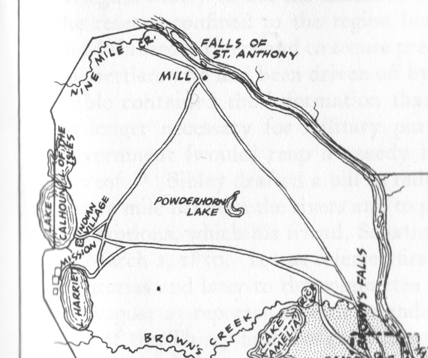
First, let’s go back to the some of the first maps of roads and paths in the area. This area of Minneapolis was part of the original Fort Snelling military reservation. And because of human use of the physical geography, there was a primary East-West route that followed fairly closely to 35th and 36th Streets. An early map from 1839 shows a triangular travel system, connecting important places in the pre-territorial landscape. There was a trail connecting Fort Snelling/Bdote to St. Anthony Falls/Owamniyonmi, following a similar path of current Minnehaha Avenue and the first railroads, later the Milwaukee Railroad. Another route connected St. Anthony Falls to Bde Maka Ska, Lake Harriet, and the village of Dakota leader Mahpiya Wicasta (Cloud Man), on the South East side of Bde Maka Ska. This road roughly follows the route of current Hennepin Avenue. From the southeast shore of Bde Maka Ska was the southern edge of our travel triangle, traveling from the lakes back to Fort Road, an east-west path passing just south of Powderhorn Lake, somewhere between current 35th and 40th Streets.
The Minneapolis street grid as we know it now was, developed after the area was opened for white settlement in the 1850s, after the 1851 land cession Treaties of Traverse des Sioux and Mendota between the United States government and the Mdewakanton, Wahpekute, Sisseton, and Wahpeton bands of Dakota. By the 1880s, the south boundary of Minneapolis was at 38th Street. Bryant School, later named Warrington School, opened in 1898 at 37th Street and 3rd Avenue (now the site of Sabathani Senior Housing). Central High School opened in 1913 at 3416 4th Avenue South (now the site of Green Central Park School). Hosmer Library, first known as the 36th Street Branch, opened in 1916 at the corner of 36th Street and 4th Ave South. Bryant Junior High (now Sabathani Community Center) opened in 1923 at 38th Street and 3rd Avenue S. Nineteen years after Hosmer Library opened, Augusta Starr, the head librarian, described how much the area had changed: “when we opened the Branch, our neighborhood was an open prairie dotted with isolated buildings. Today [1935], it is a compact city with paved streets.”
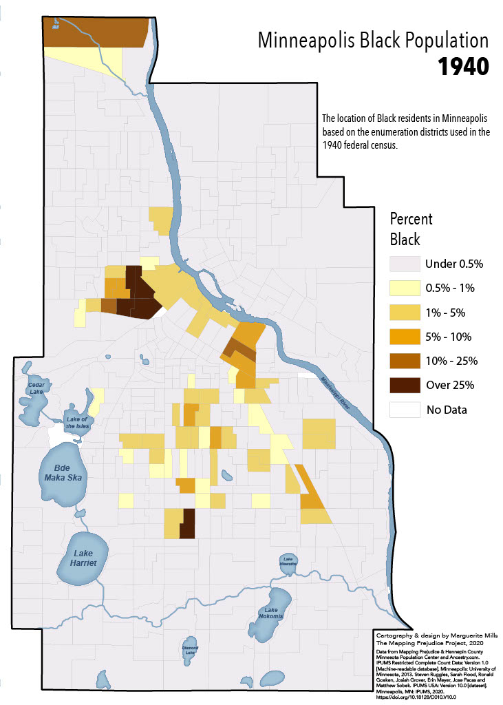
According to the U.S Census, in 1910, the population of Minneapolis was 301,408. By 1950, it had almost doubled to 521,718. Although Minneapolis still had a relatively small Black population, the Great Migration of Black families from the South to the Midwest lead to an increase in Black families in the city. With this growth, white residents and developers in Minneapolis began to worry that the “wrong” kinds of neighbors would be moving in. This led to the development of racially restrictive housing covenants, clauses put into property deeds to stop non-white people from living there. This, combined with redlining, a tool created in 1935 to rank mortgage investment risk, meant that Minneapolis became increasingly racially segregated as its population grew. Black families looking to places to live began to find the Southside of Minneapolis.
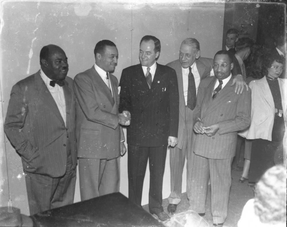
In the 2024 Old Southside oral history project, students from the University of Minnesota Public History Program interviewed people who grew up in the Old Southside in the mid-1900s. Storytellers spoke about why their families moved to this area of South Minneapolis. And consistently they noted it was because it was a place they could own their own home and raise their families. The Black community thrived in Southside. Black families owned middle-class homes, worked well-paying professional jobs, owned and ran their own businesses, and created Black cultural institutions, like the Minneapolis Spokesman newspaper, the Minneapolis-St. Paul Urban League, Dreamland Café, and many others. This thriving community is evident in the community photographs taken in the late 1940s by John Glanton. They show well-dressed people in comfortably furnished homes with civic and political power. Walter R. Scott continued the showcase with his three volumes of profiles of successful Black community members, first published in each decade between 1956 and 1976.
By mid-century, the busy commercial areas of the neighborhood were centered in areas similar to now: North and South along Nicollet and Chicago Avenues, East and West across 38th Street, with the Black commercial district centered around 38th Street and Fourth Avenue. Paging through old Minneapolis city directories, it is clear that 35th and 36th Streets were very much as they are today: leafy residential stretches, the quiet broken only by the library, a school, the bakery building at 36th Street and 5th Avenue South, and small clusters of shops like a drugstore, a grocery, and a filling station, at the intersections with Nicollet and Fourth Avenue South. That is, very much as they are today, but with two significant differences: Interstate 35W and one-way streets.
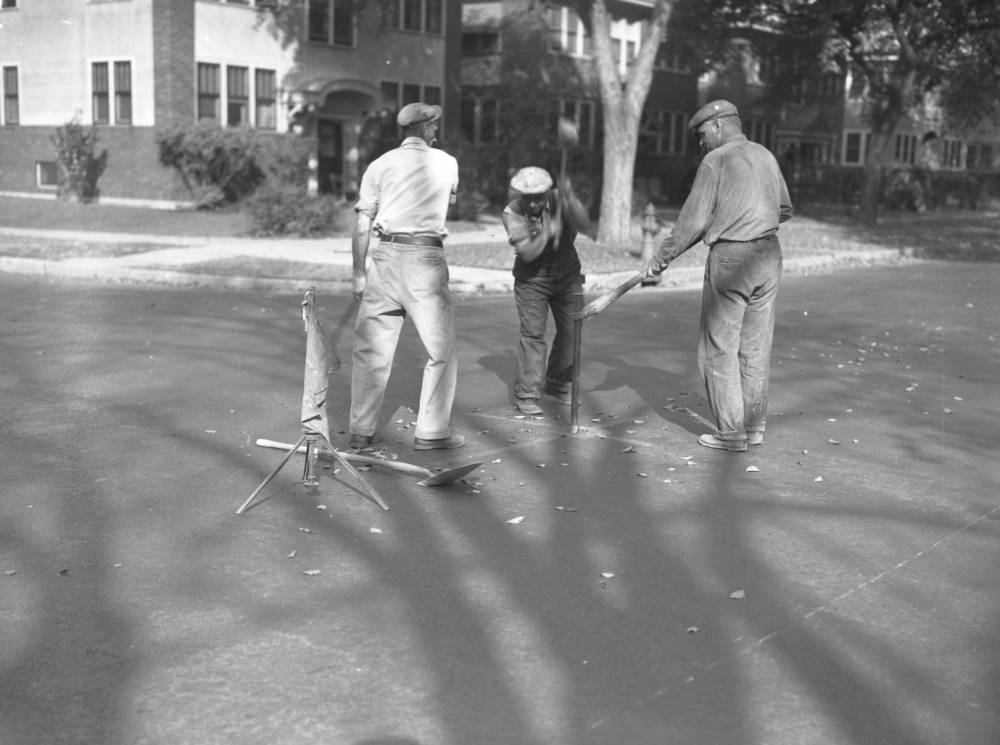
As the South Minneapolis street grid filled in with houses in the early decades of the 1900s transportation to and from the downtown area began to shift from the street car systems (and later buses) to the automobile. Constant gridlock into downtown Minneapolis showed that the street network as it had been developed before automobiles was no longer adequate. Some solutions presented themselves to city planners. One of the first was one-way streets. There started to be talk of one-way street conversions in the local newspapers as early as the 1910s, especially streets in downtown, around the University Campus, and at the notorious Groveland bottleneck at Oak Grove/Hennepin/Lowry Hill. In South Minneapolis, Park and Portland Avenues were made one-way streets in 1946 (Minneapolis Star, Nov 6, 1946) between 10th Ave downtown and 38th Street and turned into busy thoroughfares. Several months into the change, there were complaints in the newspaper of cars not stopping for the school crossing patrols (Sun, Jan 05, 1947) along 34th Street. By summer of 1947, when the plan was to extend the one-ways on Park and Portland down to Minnehaha, one letter to the editor writer called the whole thing “assinine” [sic] (Thu, Aug 28, 1947). But these one-way conversions still didn’t seem to do enough to speed cars in and out of downtown. This is when the express highway seemed like the solution.
I can’t get into everything here about the development of Interstate 35W and the impact on the Southside community. Both the Human Toll of 35W project and the research of Greg Donofrio and Dr. Ernest Lee Lloyd are excellent sources for further reading on the project. Highway construction began in South Minneapolis in the early 1960s. There was almost no public input on the urban highway project, with possibly as few as two public hearings before construction began. As Greg Donofrio notes in his essay “Public Notice,” “even one public hearing frustrated Minnesota’s construction-minded freeway engineers. MDH Commissioner Loyal Zimmerman felt that meetings were slowing down construction, as he wrote Gov. Orville Freeman in a memo about why the freeways weren’t being built faster.”
The requirements for public hearings and community input on transportation projects were very different from what they are today, but officials in the planning stages of the interstate seemed to have a hard time recognizing there was ANY community in the area to consult. Dr. Lloyd found a City Planning Commission Report from 1957 that stated “After careful study the City Planning Commission could find no functioning neighborhoods now existing in the South Corridor…. elements such as schools, parks, and shopping districts do exist of course, but the Planning Commission could not find any unified and strongly functioning groupings.”
In a later interview with Dr. Lloyd, W. Harry Davis, a prominent African-American community member who lived near 36th and Portland and who was president of the Minneapolis NAACP between 1963 and 1965, said that at the time “he was aware of the pending construction project, however, there was little African Americans could do to prevent the project due to a lack of political clout. … [M]embers of the African-American community sought answers from government officials regarding what was going on in their community as they witnessed equipment being mobilized in the area.”
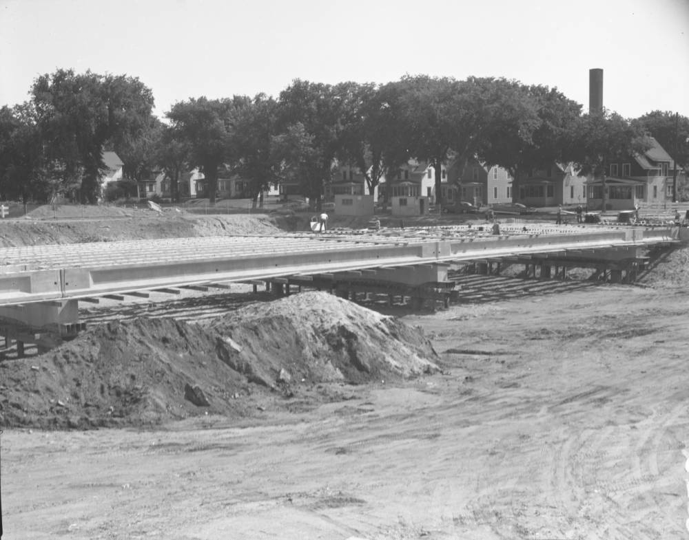
Construction of 38th Street Bridge Over Interstate 35W, 1961. Minneapolis Public Works Photographs, Hennepin County Library
At the same time that federal highway construction was dramatically changing the transportation landscape, urban renewal projects in Minneapolis were threatening low-income communities with the wrecking ball, or as Southside neighbor Gary Hines called it in his oral history interview, “Negro Removal.” Some areas of Minneapolis, like the Downtown Gateway District, saw large swaths of buildings and entire blocks demolished, many of which became parking lots still remaining today. For other south Minneapolis neighborhoods like Phillips, the initial report in 1965 recommended that “more than one out of every two buildings in Phillips be demolished.” (The Minneapolis Star Thu, Sep 09, 1965 ·Page 1)
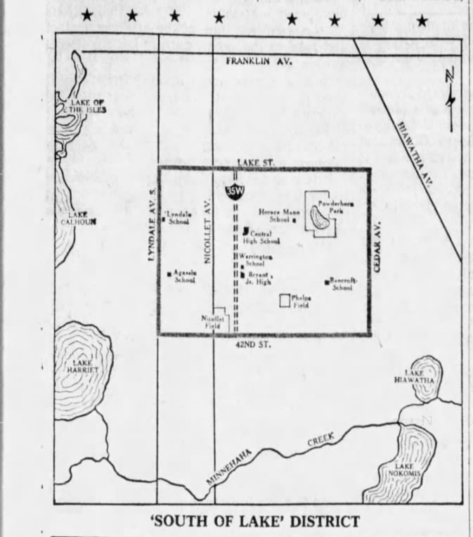
The area of what is now the Central, Lyndale, Bryant, Bancroft, and Powderhorn Park neighborhoods, also referred to as “South of Lake,” was categorized as “declining” and was considered “at-risk” for urban renewal. Minneapolis Mayor Arthur Naftalin warned residents they should “move boldly to provide the kinds of safeguards that will protect this area for continued family living.” (Minneapolis Star Jan 30, 1965, pg 5.) Although it is unclear what exactly neighbors were supposed to be protecting the community from, the community formed a new regional citizens group called “South Central Assembly of Neighbors” or SCAN. But likely to the mayor’s chagrin, the first organizing effort of this group was to protest one significant impact of the 35W project: turning 35th and 36th Streets into one-way streets.
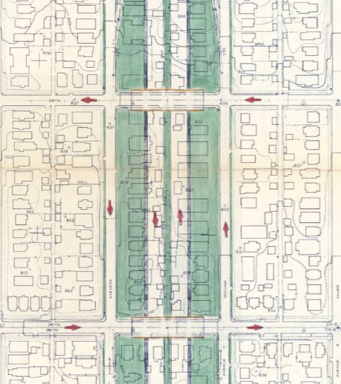
As earlier noted, there was little public input or notification of the Interstate project to the immediate community, so it is likely there was as little notification and input for related changes like the one-way street conversions. The intention to turn 35th and 36th street into one-way on and off ramp “feeders” to and from the new expressway does show up on a 1958 planning map, after the final route was decided upon. But because 35th and 36th are city streets, any changes to the traffic pattern would require City Council approval. According to the Minneapolis Star, various parts of the expressway plan started moving through the City Council’s Road and Bridges Committee in January, 1965. The new SCAN neighborhood group had one of their first meetings to “discuss the impact of freeway construction and proposed changes in traffic patterns” on March 24, 1965 at Powderhorn Park (Minneapolis Star, 3/25/65, pg 15). The guest speakers were two highway engineers, one from the City of Minneapolis and one from the State of Minnesota.
By late June 1965, momentum against the one-way plan was growing. SCAN held a meeting where the 180 neighborhood attendees expressed their objections to the plan to turn the streets into one ways. The full plan was to make 35th and 36th streets one ways all the way from Hiawatha Avenue (which was planned to be turned into a freeway) to the current Bde Maka Ska. According to the Star, “The 180 residents object to the one-way streets, saying their property values will drop, the neighborhood will lose its character and attractiveness as a place to live, and that there will be an increase in traffic problems.” (Minneapolis Star, 6.24.65, pg 29) The same week, John R. Jamieson, Minnesota highway commissioner, “scorched” Minneapolis leaders for having too many bosses who were slowing down the process. Complaining specifically about the protests against the 35th and 36th street one-way plans, one engineer was quoted in The Star as saying, “We can’t afford a long delay in this matter.” (Minneapolis Star, 6.26.65, pg 5).
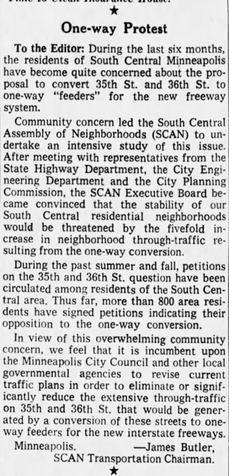
SCAN’s protests continued on through the summer and fall, according to local reporting, with more community meetings and finally requesting a public hearing on the matter before the City Council’s Road and Bridges Committee. In a letter to the editor on November 8, 1965, James Butler, the chair of SCAN’s Transportation Committee, presented the results of a neighborhood petition which more than 800 area residents had signed in opposition to the one-way plan. This finally got the attention of some city aldermen, who agreed to meet with the group. Ward 10 Alderman Jack Newton publicly came out as opposed to the one-way plan, saying he would put the “needs of the neighborhood before the demands of the automobile.”
But by February 1966, it seemed that the neighborhood had lost, or at least SOME of the neighborhood had lost. The Roads and Bridges Committee approved parts of the one-way plan, from Emerson to Chicago Avenues, but left the sections of 35th and 36th streets to the east and west as two-way streets. In May 1966, SCAN gave a report on its one-year anniversary, claiming victory that they got the one-ways partially reduced. It is probably not a coincidence that the stretch of 35th/36th that are one-ways today exactly coincide with the east-west boundaries of the Southside African American Community with Nicollet on the west and Chicago Avenue on the east. It isn’t clear how SCAN engaged with the African-American community at the heart of its boundaries. The named committee chairs all appear to have been white, and I can’t find any reporting on the protest against the one-way streets in the Minneapolis Spokesman, the African American newspaper.
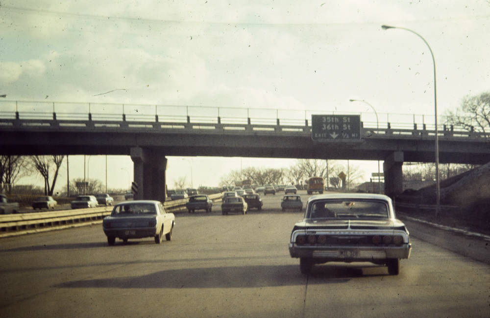
After Interstate 35W opened and 35th and 36th streets were converted into one-way streets, the neighborhood shifted. According to census research by Dr. Lloyd, the black neighborhood contracted. The western boundary shifted from Nicollet Avenue to 35W, making the area more segregated. White flight increased as property values near the freeway went down and the area became seen as less desirable. School boundaries and attendance also shifted, resulting in Bryant Junior High closing in 1978, followed by Central High School in 1982. In an oral history interview, Harry Davis Jr, (the son of W. Harry Davis) and Louis Moore noted that “when you close a high school you kill half the community.” Throughout all of this time, from the 1960s through the early 1990s, there were rumblings of efforts to close Hosmer Library too. But this time, the community was able to stop their last remaining educational institution from being removed.
There have been many great losses in this community, which is not to diminish the community that is here today along and around 35th and 36th Streets. But one common thread I have noticed in my research and the conversations I’ve had with community members, is how caring, connected and cohesive the neighborhood felt to the people who grew up here. I know that whatever the final plan is for the reconstruction of 35th and 36th Streets, it will never fully repair past harms. Yet I think about the library kids I know today. I want them to experience that same sense of connection and care. Through these generational street construction projects, we get to decide what our streets are for. Are they for speeding car traffic quickly through residential neighborhoods on our way to somewhere else? Or are they tools for growing connections and relationships, and bringing neighbors together? If you believe the answer is the latter, how are you going to show up for the promise of a new 35th and 36th Street?
Further Reading:
Mapping Prejudice identifies and maps racial covenants, clauses that were inserted into property deeds to keep people who were not White from buying or occupying homes. From our base in the University of Minnesota Libraries, our interdisciplinary team collaborates with community members to expose the history of structural racism and support the work of reparations.
MNopedia article about the old Southside African American Community in Minneapolis
The Scott Collection In the 1950s, ’60s, and ’70s, Minneapolis resident Walter R. Scott produced a series of books profiling the African American community of the Twin Cities. The Scott Collection brings back into print these fascinating documents of African American life and history in the Twin Cities.
The Hennepin County Library Yearbook Collection. Hennepin County Library has many Minneapolis yearbooks online or in special collections, including Central High School and Bryant Junior High
The John F. Glanton Collection. Over 800 photographs of the African-American community in Minneapolis and St. Paul in the late 1940s. Donated by Joan Glanton Howard and Anthony Scott.
Minnesota Spokesman-Recorder digitized newspapers through the Minnesota Historical Society. Long-running Twin Cities African American newspaper the Minnesota Spokesman-Recorder began its life on August 10, 1934 as two separate weekly titles with largely identical content: the Minneapolis Spokesman and the St. Paul Recorder. The two were founded by Cecil Newman, a leader in the Twin Cities African American community, who used his position and his papers to fight against racial discrimination locally and nationally, and to support and improve the lives of Black Minnesotans.
Southside Oral History Interviews. Conducted as part of Southside oral history project portion of HSPH 8002, University of Minnesota, Spring 2024
The Human Toll of 35W. A community-collaborative oral history and research project on 35W in South Minneapolis.
How Routing an Interstate Highway Through South Minneapolis Disrupted an African-American Neighborhood Thesis of Dr Ernest Lloyd
The digital archives of the Minneapolis Journal, the Minneapolis Star, and the Star Tribune are available to access from the Hennepin County Library.