Quite some time ago, a friend offered me an idea for an article. Reserve Block 40 — why the hell is that little park named that? No one (at least, no one who walks among the living) appeared to know. It was a mystery that had been allowed to be. Finding this all very interesting, I took up the suggestion of my friend. Working my way back through materials on the topic, I wound up tracing a circuitous path back home. The piece wound up becoming a kind of oblique auto-biography, and wound up becoming something much deeper to me than Park Board history trivia. Shall we begin?
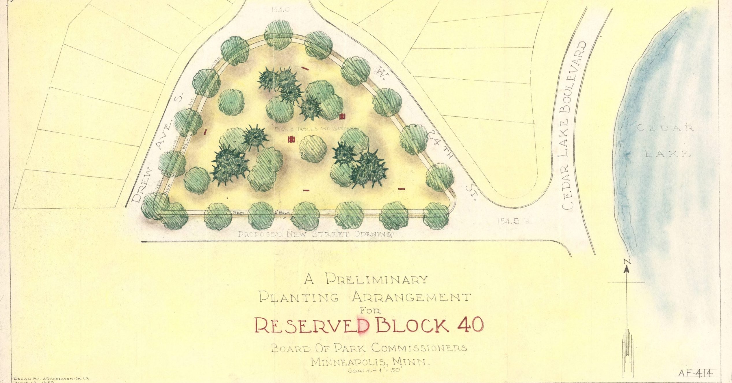
What is Reserve Block 40?
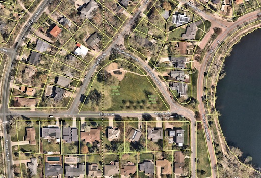
Reserve Block 40 (at 3501 West 24th Street, not far from the western shore of Cedar Lake) has the curious distinction of being one of the few Minneapolis parks to never received a proper name. Most parks are named to reflect something or someone — local or national figures of political or cultural import, their geographic features, their flora or fauna or something. Reserve Block 40 appears to be something of an afterthought, which perhaps belies some of the interesting facts related to its birth.
It should not come as a surprise that the official history of the park is ambiguous. The Park Board’s official website lists the acquisition of the park as being April 6, 1908. It doesn’t say from who, or why. Just that it was acquired. Per the 2020 Southwest Service Area Master Plan:
This triangular block of land west of Cedar Lake was part of the land designated for acquisition in 1908 that included parts of the west shore of Cedar Lake and Brownie Lake. However, the land was almost immediately forgotten as it wasn’t included in Park Board plans for the development of Cedar or Brownie Lakes.
As a matter of fact, the only mention of the park’s existence from between 1908 to 1953 occurred in a 1921 Theodore Wirth proposal to add tennis courts to the land. The park entered its current state in the early 1950s as the area around it continued to develop into suburbs in the post-war period.
But that’s all just administrative silliness; the main point is that the Park Board got it eventually. And it was “almost immediately forgotten,” to be sure, which explains that place-holder-of-a-name it still bears. The closest that it’s come is this note from the quoted Master Plan above: “A future change in the official park name may also be considered.”
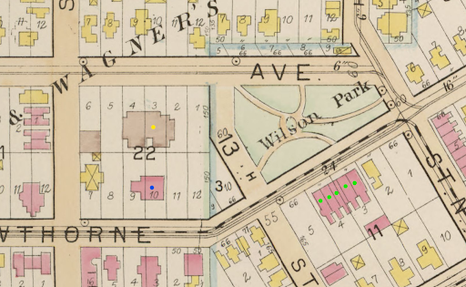
“Atlas of Minneapolis Hennepin County Minnesota. Including parts of St. Louis Park and Golden Valley Township in Hennepin County. Also Part of Ramsey County Known as the Midway District.” A sexy title, to be sure; sarcasm aside, it is one of my personal favorite reference materials for research. Published in 1914 by the Minneapolis Real Estate Board, it sheds some light on the matter. The plot appears on the lower right of plate 58 as “Reserved Block 40.”
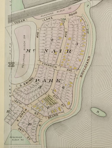
The Park Board’s own web site notes: “The park has always been referred to by its designation on plat maps in a neighborhood known as McNair Park. The park has never been officially named.”
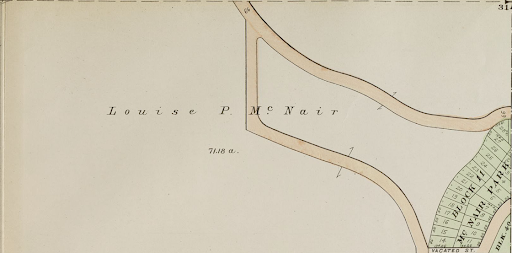
Now, looking back to Plate 58 from the 1914 Atlas, we do see that the area does indeed have an overall designation of McNair Park, the name of the addition to the city. More light is shed when we look at plate 80 of the same atlas, which shows the land in St. Louis Park that is west of the Minneapolis city limits. We see an unplatted area of land belonging to one Louise P. McNair. Just tuck that name into your back pocket for later use, please.
We will also notice our little comrade Reserve Block 40 peeking out there at the lower right, as well as the western portion of the McNair Park addition. Surely, the proximity of McNair Park to land owned by Ms. McNair is suggestive — you’ll see the connection shortly! But it involves going a little further back and delving into the life and times of her forebears.
McNair Park?
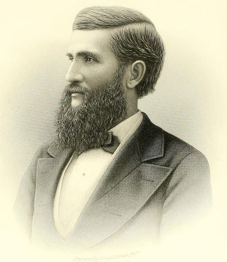
Now, William W. McNair (1836-1885) was a prominent lawyer in Minneapolis’ early days. He also served as a two-term mayor of St. Anthony from 1869-1871 (St. Anthony, occupying what is now NE Minneapolis, would be annexed by the city in 1872). Much like his contemporary Thomas Lowry, he supplemented his legal and political careers with investments in land and real estate.
Ancestry.com informs me that McNair had several children, including one Louise Pierpont McNair (1870-1936). We can presume then that this is our Louise P. McNair from the map, named for William’s mother Sara Landon Pierpont (1802-1895) and wife Louise Caroline Wilson (1840-1918). We’ll add Louise Wilson McNair to our list of names in our back pocket; a mother-daughter duo.
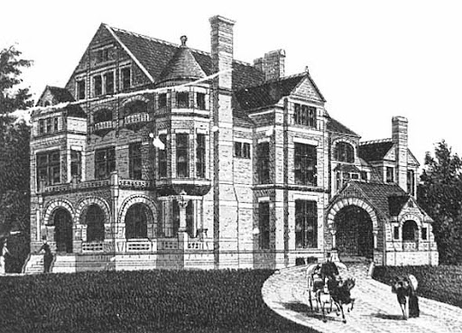
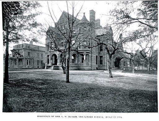
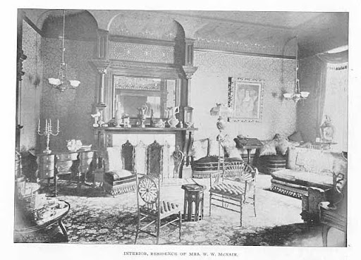
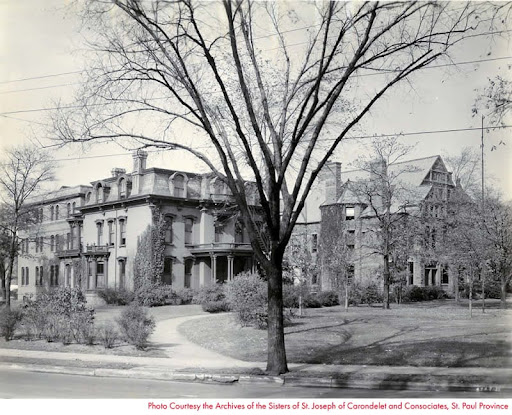
In typical Victorian fashion, William McNair built an enormous red sandstone Romanesque Mansion at 1301 Linden in 1884 to serve as testimony to his achievements. The year is not a coincidental one — 1884 was such a peak year for real estate development in Minneapolis that the city began keeping building permits. And, in even more typically Victorian fashion, he died in 1885 after living in it for less than a year. Very few of these men ever really lived in their houses.
Yada yada yada, another old-timey rich white guy who made money in real estate and politics and built a big now-demolished mansion downtown. It’s 2025, who cares? Well, I’ll tell you a bit about why I care. It gets a little tangled, but you may find it interesting!
As visible in the photograph of the house, you can see that in the background appears a smaller, mansard-roofed structure, built probably 10 (or so) years earlier, based on the style. In 1872, mansards and Second Empire architectural styles were the height of fashion.
The houses sat in the Wilson, Bell & Wagner’s addition just north of the present location of the Basilica of Saint Mary. And . . . the house was the residence of Louise Wilson McNair’s brother Eugene, prominent pioneer lawyer, 5th mayor of Minneapolis, founding park board member and… law partner of her husband. Or perhaps, she was the sister of her husband’s law partner, depending on your point of view. In fact, the McNair Mansion was built on what was formerly the lawn of the home. Together the homes occupied a full city block and sat across from what was at the time known as Wilson Park (named for reasons you might suspect — as a historical footnote, it appears as early as 1892 as Wilson Park; by 1914 it appears as Hawthorne Park and by the end of its life in 1961 appears to have been back to Wilson again).
Now, a young lawyer real estate developer marrying into the family of pre-existing land-owners was and is hardly unusual. Thomas Lowry did the same thing with his wife Beatrice, daughter of Calvin Goodrich, who owned plenty of land in what is now parts of Lowry Hill. Indeed, such unions are still quite common, although assets are now more inclined to be digital in this day and age.
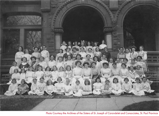
Returning to the theme of what was typical for the era, after the death of the esteemed husband, the widow did not care to linger in the home too long. By the early 1900s, the houses were likely vacant and for sale. Archbishop John Ireland took interest in the vacant mansions and purchased them in 1904. After deeming their site ultimately unsuitable for a basilica, he sold them to the Sisters of St. Joseph Carondelet in 1907, and they would go on to be the campus for Saint Margaret’s Academy. The ultimate site of the basilica would occupy a lot owned by Lawrence S. Donaldson (as in, the Donaldson’s department store that would be in business until 1987), which he donated in 1905 for the construction of the Basilica of Saint Mary, only a block or so to the south.
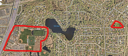
St. Margaret’s would occupy the buildings until 1960, and they were felled in 1961 for highway construction that wiped the elegant neighborhood north of the Basilica centered on Hawthorne Park off the map. The images below compare the map of 1914 to the satellite view of today. The Swinford apartments, the most important surviving buildings visible in both views, are marked with green dots.


Okay, okay . . . dead white politician-real-estate-guy. Check. Dies young, leaves widow huge mansion. Check. Widow donates mansion to charity of choice. Check. Said mansion is in neighborhood significantly altered by urban renewal. Check. Couple has children who inherit money and land. Check. Some land donated or sold to Park Board to create a park within one of their real estate developments. Check.
Again, it’s 2025 . . . we’ve heard all of this story before. It’s not special. So why are we talking about it? Give me just a little bit more of your time.
St. Margaret’s
In 1960 the Academy moved to new buildings in Bryn Mar; you may recognize them as Anwatin Middle School. The school sold them to the Minneapolis Public Schools in 1974, and subsequent additions have created Bryn Mar Elementary in the space between the original school buildings, chapel and nuns’ residence.
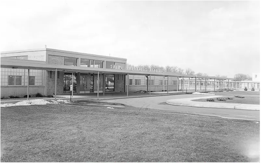
And in 1974, declining enrollment led St. Margaret’s Academy to merge with Benilde, a boys’ Catholic school with attendance shortfalls of its own. The combined schools campus is located a handful of blocks from Reserve Block 40.
And the interest there? Your author spent a couple of years attending Benilde-St.Margaret’s himself. So did my sisters, and the St. Louis Park campus was a second home for many years of my youth, attending my sibling’s soccer games; wandering under the bleachers, breathing the fresh scent from wetlands that ring the eastern side of the property, marvelling at the strands of ‘cotton’ from the stands of cottonwoods that divide the athletic field from the lake on the other side.
And those milestones of nervous, anxious youth — as mundane as running the mile, as sublime as a first boyfriend (queers? At Catholic school? More likely than you think). As embarrassing as skipping gym for nearly a whole semester to read in the library because I was too nervous to be around the other boys as we changed. Ah, too be a self-conscious teenager instead of a self-conscious adult. Looking back on those days, it’s hard not to laugh at my old self, but I’m finding it easier to love him for who he was and who he is, in fact, still becoming.
It’s also hard not to look back with a renewed appreciation for the social justice teachings inoculated at the school, a heritage from the Christian Brothers who founded Benilde and the Sisters of Saint Joseph Carondelet who founded St. Margaret’s. This is something many people who were raised Catholic go through (if they’re lucky) in forgiving the failings and downsides of such an upbringing, and hopefully finding the forgiveness for both themselves and others necessary to recognize the lives of charity and service that can be found as models for those of us who want to create a better world for ourselves and others.
And all this, from a little park!
Truth be told, I was not expecting for the innocuously named Reserve Block 40 to lead back to the history of my school that was taught to me as a high schooler. I wasn’t expecting it to connect me to Anwatin Middle School, which is the school some of the children of my neighborhood attend. But like so much in this world, once you dig beyond the superficial level, it really is all intricately interconnected. And that, my friends, is the story of how Reserve(d) Block 40 (didn’t) get its name.