Trunk Highway 36 is today known as the primary high-speed artery connecting the Twin Cities to the town of Stillwater. Its history shows how Highway 36 took shape incrementally, shaped by decisions that were often reactive.
The 1933 “Disjointed Mess”
Trunk Highway 36 today functions as one of the Twin Cities’ most important east–west corridors, carrying commuters from Roseville to Stillwater at freeway speeds that would have been unimaginable when the route was first designated. Traffic volumes today peak at nearly 90,000 vehicles per day near its western junction with the Interstate 35W; while that figure tapers as the road moves east, roughly 30,000 vehicles still cross the St. Croix River daily into Wisconsin.
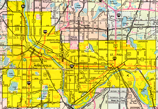
In the 1930s, traversing Highway 36 wasn’t easy. A driver heading east would have to treat the route like a scavenger hunt, threading a sedan through the industrial grit of Minneapolis’s Broadway Street before zigzagging across unpaved county lanes that felt more like farm paths than a regional artery.
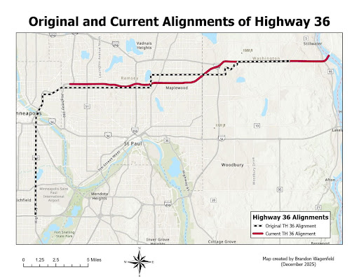
When the Minnesota Legislature designated the route in 1933, it bore little resemblance to today’s corridor. In addition to the Roseville-to-Stillwater segment we know, Highway 36 was signed along Cedar Avenue in Richfield and south Minneapolis, winding through the Seven Corners neighborhood just east of downtown and crossing the Mississippi River via the 10th Avenue Bridge into Dinkytown. It followed Broadway Street NE through the city’s industrial corridor.
Outside of Minneapolis, it relied on a patchwork of existing township roads—future County Road B through Roseville and future County Road C in North St. Paul—taking sharp 90-degree turns to avoid Keller Lake and Gervais Lake, and tracing Demontreville Trail. For years, the designation ended at Stillwater Boulevard (then-U.S. Route 212) in Washington County, falling several miles short of the St. Croix River.
This wasn’t a product of poor planning. There was not yet the traffic to justify building a continuous route to Stillwater, let alone a high-speed freeway. In more urbanized areas like Minneapolis, highway-building was constrained by quirks in the Babcock Amendment, which established Minnesota’s original Trunk Highway System in 1920.
The original system was designed explicitly to qualify for funding under the Federal-Aid Road Act of 1916. That program prioritized “rural post roads” and, by statutory definition, excluded cities with populations over 2,500. As a result, the state was initially prohibited from spending trunk highway funds on city streets. Highway Commissioner Charles Babcock noted that before 1933 the state did not spend a single dollar maintaining these urban links.
Much of the early Highway 36 alignment remained unpaved or minimally improved. In rural segments, gravel surfaces were common, while urban portions relied on city streets never designed to carry sustained through-traffic. The idea that these segments might someday be consolidated into a high-speed expressway would have seemed implausible in the early 1930s. Highway travel at the time was still conceived primarily as an intercity or agricultural function, not as a daily commuting system binding together a metropolitan region.
Over the next three decades, as population growth crept outward from the Twin Cities and automobile ownership slowly expanded, Highway 36 would be realigned, paved, widened, and gradually separated from local streets— through a series of adjustments. This included the rise of the regional shopping mall and the rapid incorporation of new ‘inner-ring’ suburbs like Roseville and Maplewood.

Timeline of Alignment Changes:
1933 – 1935: These shifts (Demontreville Trail to Viking Drive) represent the state trying to “straighten the line” as they moved away from existing farm-to-market trails toward dedicated highway rights-of-way.
1940: Shift from County Road B to a new roadway through Roseville. This is when the highway stopped being a guest on County Road B and became its own distinct roadbed. This essentially paved the way for Roseville to become the retail hub it is today (Rosedale Center, etc.). Before the malls, this was the beginning of the “auto-oriented” commercial zoning that still dominates the area.
1955: Shift from County Road C to a continuous expressway from Roseville to Stillwater. This corresponds with the post-war funding boom. By 1955, the “continuous highway” was a four-lane divided road, though it still had many “at-grade” intersections (stoplights).
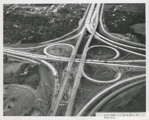
1962: While the interchange was a massive milestone, I-35E itself was built in sections. The segment from Hwy 36 south into St. Paul wasn’t fully “open” in the way we think of it until later, but the interchange structure itself was indeed a 1960s-era project that signaled the end of 36 as a “local” road.
The Post-War Explosion: 1950–1960
The transformation of Highway 36 from a loosely connected gravel route into a continuous expressway was driven by a dramatic shift in how Twin Cities residents lived, worked, and moved in the decade following World War II. The 1950s marked a turning point in regional mobility, as automobile ownership surged far faster than population growth and fundamentally reshaped daily travel patterns. This era also saw the birth of Har Mar Mall (1961) and Rosedale Center (1969) right alongside and near the Highway 36 corridor.
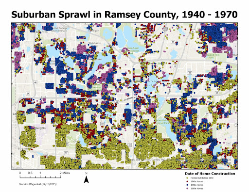
Between 1950 and 1960, vehicle registrations in the Twin Cities metropolitan area increased by approximately 62 percent, while the population grew by just 29 percent. By 1958, an estimated 83 percent of metro-area households owned at least one automobile and personal vehicles now accounted for roughly 88 percent of all trips. At the same time, transit usage collapsed. Streetcars and buses, which had carried more than a quarter of trips in 1949, were responsible for just 12 percent of trips less than a decade later.
Federal housing policy, cheap gasoline, and postwar prosperity also combined to make suburban homeownership both accessible and desirable. As these new residents moved in, the formerly quiet county roads that made up Highway 36 were suddenly overwhelmed by a volume of commuter traffic they were never designed to sustain. North St. Paul’s population doubled during the 1950s. Roseville’s population nearly quadrupled. Maplewood incorporated as a city in 1957, in part to avoid annexation by St. Paul and to assert greater control over its rapidly developing land.
Corporate investment followed closely behind residential growth. In the early 1950s, 3M began constructing what would become its sprawling corporate headquarters campus in Maplewood, reinforcing the corridor’s emerging role as a center of employment as well as housing. These developments generated new travel demands for existing roads. Many are still narrow, at-grade, and locally maintained and they were never designed to accommodate. 3M chose this site specifically because it was near the intersection of the proposed I-94 and the existing Highway 36.
The Minnesota Highway Department largely reacted to problems as they arose and nowhere was this more evident than at the Rice Street intersection, which remained a signalized bottleneck for decades, forcing regional commuters to grind to a halt at a local street corner well into the 1990s traffic volumes along key north–south crossings, particularly Rice Street, more than doubled between 1949 and 1958. Congestion, delays, and safety concerns mounted as local intersections attempted to handle regional traffic.
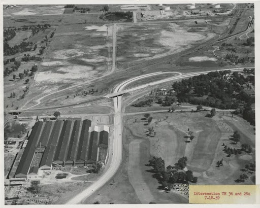
The state began systematically upgrading Highway 36 east of Roseville. By the end of the decade, most of the corridor between Roseville and Stillwater had been converted into an expressway, featuring limited access points, divided lanes, and grade-separated interchanges. This period saw the construction of some of the East Metro’s earliest cloverleaf interchanges, including those at Highway 61 in 1955 and Highway 51 in 1958. These designs prioritized uninterrupted vehicle flow and reflected the assumption that future mobility would be automobile-based.
These improvements were implemented incrementally, usually in response to immediate traffic pressures rather than as part of a comprehensive regional plan.
The Forgotten “Backbone Plan”
Highway 36 was not initially envisioned as the East Metro’s primary east–west corridor. In fact, early regional transportation planning placed that role elsewhere. The Minnesota Highway Department’s 1966 Initial Service Level Plan identified Stillwater Boulevard—then designated as U.S. Route 212—as the preferred expressway connection between St. Paul and the eastern suburbs.
From a mid-century planning perspective, the decision was defensible. Stillwater Boulevard already functioned as a major arterial serving established neighborhoods and commercial districts along St. Paul’s eastern edge. Highway 36, by contrast, remained incomplete and uneven in its design, with lingering at-grade intersections and limited continuity west of Roseville. From a mid-century planning perspective, the older, more developed corridor appeared to offer a clearer path to expressway status.
By 1972, however, the state’sBackbone Plan—a framework intended to prioritize and rationalize the region’s most critical highway investments—formally elevated Highway 36 to the role of primary east–west expressway, supplanting U.S. 212 in the process.
One of the most significant catalysts was the opening of Rosedale Center in 1969. As one of Minnesota’s earliest enclosed regional shopping malls, Rosedale quickly became a major traffic generator, drawing visitors from across the metropolitan area. Its location near the intersection of Highway 36 and Fairview Avenue placed new pressure on a corridor already strained by commuter traffic. The subsequent construction of the Fairview Avenue interchange signaled a broader reorientation and it meant that Highway 36 was now a regional backbone serving retail, employment, and residential travel.
At the same time, the late 1960s marked the high-water point of freeway construction nationwide. Simultaneously, community opposition to urban highway projects was growing.
In Minnesota, this transition was both symbolic and institutional. In 1976, the Highway Department was renamed the Minnesota Department of Transportation, reflecting a broader mandate that now included transit, multimodal planning, and system management rather than pure roadway expansion. Large-scale highway ambitions gave way to targeted investments, improvements, and long pauses between major projects. This “institutional shift” is why Highway 36 wasn’t finished as a freeway until the 2000s. The 1976 shift essentially put “new” freeway segments on the back burner in favor of maintaining the existing urban core.
James Harrington was the first Commissioner of MnDOT, when the agency was formed in 1976, and was tasked with this very pivot from concrete to coordination. Under Harrington, the agency’s focus shifted to ‘managing’ congestion rather than ‘building’ out of it. For Highway 36, this meant the grand plans for a seamless, stoplight-free corridor were shelved in favor of lower-cost safety patches and maintenance, leaving a generation of drivers to navigate a hybrid system of high-speed stretches and sudden, dangerous intersections.
Unlike the interstates, which benefited from sustained federal funding and clear design mandates, Highway 36 lingered in a liminal space: too important to ignore, but not important enough to complete. This “liminal space” is why the North St. Paul “missing link” became such a legend of Twin Cities traffic.
The Modern Era: Solving the “Bizarre” Gaps
By the early 1970s, Highway 36 had largely assumed the form it retains today: a 55-mph freeway carrying regional traffic across the northeastern Twin Cities metro, but where drivers were still forced to occasionally stop at traffic signals.
For nearly four decades, no new interchanges were constructed. Highway 36 appeared frozen in a half-finished state. New federal environmental review requirements made smaller, incremental improvements easier to advance than larger interchange projects.
Furthermore, the oil crises of the 1970s dramatically increased the cost of construction and diminished fuel tax revenues at a time when public support for large-scale freeway projects were already on the decline.
Local roads intersected the expressway at grade, creating conflict points that stood out sharply against otherwise freeway-like conditions. To many drivers, these gaps felt bizarre: why would a major regional highway still stop at a traffic light?
While MnDOT owns and maintains Highway 36 itself, the roads that cross it are frequently under city or county jurisdiction. Because local governments manage far smaller geographic areas, intersections along Highway 36 often represent a higher priority for them than for the state. Improvements therefore require complex coordination, shared funding agreements, and—in many cases—local initiative to move projects forward.
Oftentimes such a mismatch in state-local priorities—especially when the road is no longer serving a “regional” purpose—necessitates a “turnback,” where the state transfers a road to a county or municipality. In these scenarios, MnDOT pays the locality assuming control of the road, and that locality often stipulates that MnDOT make major repairs before the hand-off.
When MnDOT does not make those repairs and lacks the funds for a turnback, the road is stuck in a holding pattern. Trunk Highway 120—the last street west of I-694 that still intersects Highway 36 at-grade—is a perfect example of this dynamic. There is no local party responsible for highways 36 or 120, partially explaining why the comparatively less traveled Hadley Avenue was grade-separated earlier.
Property ownership further complicates the picture. In several segments, MnDOT does not hold full right-of-way but instead operates under easements negotiated decades earlier. Expanding or reconfiguring intersections in these areas can require acquiring additional land, navigating environmental review, and addressing nearby residential or commercial impacts. Each improvement becomes a discrete project.
A significant shift finally occurred in the early 2000s, as safety concerns and congestion reached a tipping point. Commuters in 2007 faced the unthinkable: a full, year-long closure of the corridor through North St. Paul. In place of six closely spaced intersections, the state constructed a single grade-separated interchange at McKnight Road, dramatically improving traffic flow and safety. At the same time, while the cars got a freeway, the residents of North St. Paul got a dedicated bridge for the Gateway State Trail, finally allowing cyclists and hikers to cross the highway safely. It’s a great example of multimodal “mitigation.”
That project marked the beginning of a renewed effort to address Highway 36’s most problematic gaps. Over the next decade and a half, additional intersections were converted or removed, including improvements at English Street and Hinton Trail in 2013, Hadley Avenue in 2020, and Manning Avenue in 2022. Each project aimed to reduce conflict points and brought the corridor closer to full expressway standards. The completion of the St. Croix Crossing in 2017 acted as a fiscal catalyst for the remaining eastern segments. By creating a high-capacity gateway to Wisconsin, the bridge made the ‘stoplight-riddled’ stretches in Oakdale and Lake Elmo an intolerable regional liability, finally unlocking the funding necessary to bridge Manning and Hadley Avenues.
As MnDOT prepares to break ground on the Lake Elmo Avenue interchange, Highway 36 approaches a milestone long deferred. Nearly one hundred years after its designation, the corridor is finally approaching the level of continuity envisioned by generations of planners responding to the needs of their moment.
Conclusion
The story of Highway 36 is a record of how Minnesota adapted— imperfectly and sometimes relunctantly—to a century of changing mobility, governance, and land use. The result of that adaptation is a highway that works—mostly—but bears visible evidence of the decisions that shaped it.
This publication was made possible in part by the people of Minnesota through a grant funded by an appropriation to the Minnesota Historical Society from the Minnesota Arts and Cultural Heritage Fund. Any views, findings, opinions, conclusions, or recommendations expressed in this publication are those of the authors and do not necessarily represent those of the State of Minnesota, the Minnesota Historical Society, or the Minnesota Historic Resources Advisory Committee.