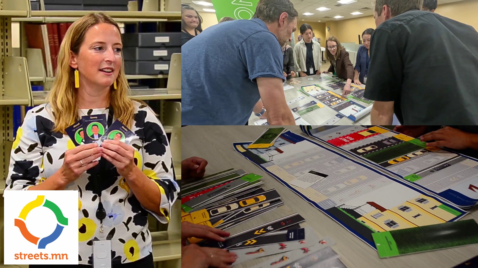
How do you take something as technical as designing a street layout and make it accessible to the majority of people? MnDOT’s Office of Research and Innovation is making it into a tabletop game.
Video available on YouTube and PeerTube.
Links
Attributions
Recorded, edited, and transcribed by Ian R Buck.
Thanks to Tyler Bybee for lending camera equipment!
Thanks to Nissa Tupper for coming on the show!
Music: Tans den Dobberstein by Erik Brandt and the Urban Hillbilly Quartet.
Transcript
[00:00:02] Ian: This may look like a board game, but these are pieces of a MnDOT Complete Streets Engagement Kit. You’ll see this in action in a minute, but first we need to learn more about Complete Streets from Nissa Tupper, who is the Integration Unit Supervisor at MnDOT’s Office of Sustainability and Public Health. I’m Ian R. Buck. Welcome to Streets.mn, where we talk about transportation and land use issues in Minnesota. Let’s jump in.
[00:00:35] Nissa: So what is a Complete Street? Well, I will say there isn’t a singular Complete Street. What we like to talk about is a Complete Streets approach, because there definitely is not a one-size-fits-all solution. So Complete Streets approach, by that I mean our planning, our design, our maintenance and operations are considering the needs of all road users, especially those who are most vulnerable from a safety standpoint. They’re responsive to local context and what the community needs are, and they’re grounded in relative vulnerability. MnDOT, our first Complete Streets policy was put in place in 2013, and that was in response to state statute that directed MnDOT to apply a Complete Streets approach to all of our eligible projects, from planning all the way to maintenance and operations. So that policy has gone through some revisions over time, and in 2022, we went through quite a big overhaul. and created a new Complete Streets handbook that has a more defined process for how to apply the Complete Streets approach. What are different staff responsibilities and expectations around applying that approach? How do we document it? What are our performance measures? One is that it’s now grounded in relative vulnerability. So, if you think about, you know, people walking, people biking, people taking transit are likely more vulnerable when using our transportation system than people who are driving. So by nature, they’re higher in that kind of baseline hierarchy, as we like to call it, of safety needs. And then we overlay that on community context, similar to like land use context. But community context is really our way of saying, you know, is this a suburban commercial area? Is this an urban area? Is this a rural area? To help us start asking those questions around what kind of places are people going to want to visit around here? What types of uses are present? And give us a sense for how might we need to calibrate our planning and our design to meet those needs? Not only what are they now, but what does the community have planned in the future? Because we know these transportation projects can often be, you know, once in a generation projects. And so how do we meet those needs for the next 50 years too?
[00:02:49] Nissa: Complete streets aren’t only for reconstruction projects, and they’re not only for urban dense, densely populated areas. You can apply a complete streets approach in a rural area. So what does that look like? You know, you’re driving long stretches between town. For example, one opportunity often is how, why do we make that shoulder? How often are people trying to use that shoulder to get in their daily walk? How often do they need to use that shoulder to safely transport farm equipment? Or do we have an Amish community that travels outside of our driving lanes versus a lot of our highways? So we have a lot of highways that are in the metro area. And we also do have a lot of highways within the metro area that are main streets. If you think about Snelling, University. Thinking about that context in terms of how can design help inform safer travel by all people who are using the roadway. So it’s about, you know, we have to do that throughput in terms of managing a highway system. But we also need to be sensitive to that local context and those needs that we shouldn’t be driving 60 miles through a small town, right? Like where might there be, um, schools, um, businesses, hospitals, places where, um, people in town either need to cross across or use that roadway. Um, or we might want to slow down traffic to visit some of those businesses. Yeah. We have a lot of examples like this. It was an American transportation award in Hackensack, Minnesota. It’s a very Minnesotan name. Um, a community has grown up around, um, a highway and the needs change. And, you know, perhaps there weren’t, um, uh, safe delineated spaces for people to walk. There’s now more activity. We need that. And so it might seem, um, you know, simple from a bystander’s viewpoint to add some sidewalks or add bump outs, you know, so there’s more visibility, but they really do make a huge difference in that mobility and safety for, um, community members in terms of, you know, getting around to access their daily needs. So that’s what I wanted to highlight.
[00:04:48] Nissa: You know, because change, change is hard, any type of change is. And so when you’re asking a community to envision something different. Um, it can be really difficult unless they see tangible examples. The kits really are, um, a tactile way to engage people, um, in, uh, decision-making around multimodal design. What does it mean when I condense a driving lane and add, you know, space over here? What does it mean, um, when I remove a turn lane and remove parking lane, how does that impact how people could use the space? What does it mean for people driving? What does it mean for people walking? Um, what does it mean for green infrastructure? Uh, there are all these types of decisions that, you know, are made throughout the transportation process that have trade-offs. Um, and, you know, it’s really hard to conceptualize and there’s a lot of industry jargon in transportation like many other fields. Um, so, you know, we wanted to create a more approachable way to engage people, um, in like what that decision-making is like. And, you know, I guess a nod to empathetic design, right? Like getting, getting out of your own shoes and understanding what it might be like to be somebody else who has needs on this roadway. Um, and what’s the impact of one decision, you know, is it about, um, repair of the current system? Is it about mode shift? Is it when we’re talking about safety, is it physical or psychological? You know, what, what does, um, you know, this change mean for people of different ages or experiences or abilities? So the kits have different base maps. They’re modeled kind of after Streetmix, the interactive online version where you can move pieces of a street around if you’re looking at like a cross section. Um, and so this is a, we have base maps of different context categories, if you will. So, you know, here’s a, a traditional standard width of a road in rural Minnesota. Here’s a traditional width of a road in, you know, an urban town. And then there’s little game pieces, if you will, of different, um, three different zones of the street. And those different game pieces can be swapped in. They have names, descriptions. Um, widths, you know, this is two feet, this is 12 feet. Um, so there’s a walkway and bike lane zone. Um, so, you know, those are the things that like, um, bike lanes, um, sidewalks, those multi-use trails. There’s the buffer zone. Um, that’s kind of the fun, fun category of, of some of the more non-traditional things, um, like furnishing zones, ditches, um, rain gardens. Um, you know, the, the sometimes seen as, extra, but we’re hoping to see more as, um, needed infrastructure to support walking and biking environments. And then the traveled ways. So those things more typically associated with driving. Folks can either, um, use them in kind of a free play setting. So I’ve, I’ve gone to like career fairs and had it out and engaged people and like, “Hey, you know, do you have a, you know, here’s a, here’s a project, like what’s your ideal street design? Let’s talk about it.” And they can play around with the pieces and ask questions. Um, to more formal trainings where we actually have, um, a project and we’re trying to figure out what that, um, cross-section should look like. And then we also have persona cards, um, to, um, have people put themselves in someone else’s shoes. So, “Hey, I’m a truck driver going through here. What are my priorities?” “Hey, I’m a kid that likes to bike to school. What are my priorities?” So that they can really engage in having a conversation about those real trade-offs that we hear. And then when we debrief it’s often like, “wow, I didn’t, I didn’t think about those things, or that was really enlightening. And I think I’m going to change my idea.” And when we’ve had it in, um, trainings, it’s fascinating because groups all have a different design and we’ll go around the room and we have the same problem statement at the beginning and there’s a different approach to each one. So it’s been pretty enlightening.
[00:08:40] Nissa: So the idea actually came from one of our Complete Streets trainings. Um, we, uh, as an agency, it kind of took a break from in-person trainings over COVID. And then, um, uh, restarted that with Complete Streets when we refreshed the policy in 2022. So with our, our updated curriculum, uh, for the updated handbook, uh, we thought, you know, we really need some hands-on activities as part of, as part of the training. So the first version of these kits was part of that training and we got really great feedback from staff. It was a training just for staff on the new policy and the new handbook. And some of our planners, um, said, “Hey, this would be a really great engagement tool. Like, do you think you could create some versions that we could use in outreach events?” Um, so we built it into our next contract and specifically worked on, um, creating these kits for our, our partners throughout the state to use. Um, so now each, um, each MnDOT district has at least one kit, um, that can be checked out, if you will, either for staff to use at like tabling events or engagement events, um, either on specific projects or just general transportation, um, you know, awareness and engagement. Um, and then we also have a number of kits, um, in our office that can be checked out. We have had some consulting partners reach out to utilize them as well, um, and some local partners like local public health, um, often get involved with like supporting complete streets. And then, um, we still use them in our, in our training. So we’re trying to get them, get them out there and being used, like you said, either with staff or with, um, um, the public, and then gather feedback on, you know, what kind of changes we should be making and tracking their use.
[00:10:22] Nissa: So where can you expect to see them? So I will say that use of the kits is optional. You know, they’re one of many ways that our project management staff and planners and engagement folks can be engaging people. So they won’t necessarily be at every project open house, for example. Metro district, I’ve heard that they’re starting to use them for in-person meetings specific to projects during scoping when they’re starting to make those, have those discussions about trade-offs. And then also using some for engagement a little bit earlier during like the planning phases to give people an idea of what might fit on that street or, you know, what might need to give and take there. So we’ll, it does really vary in terms of when they’re being used. But I would say if folks are interested in having the kits be at an event or have somebody from MnDOT, reach out to one of our staffers. We do have a general, there’s a Complete Streets webpage on the MnDOT site. Contact information is on there and certainly request that. I’m really excited that we have them as an engagement opportunity. We have some other tactile engagement kits, if you will, like Bridge in a Bag that I think a lot of people are familiar with. They, you know, go around to classrooms. I think over time, it would be great if we could scale something like this for broader use. So it depends on capacity, depends on interest. But for now, I hope that, you know, folks, it offers a good way for folks to get engaged in understanding multimodal design and also for staff to use as a communication tool and understanding what people’s needs are.
[00:11:56] Nissa: We’ve shared the kit with a summer camp through the Center for Transportation Studies, and the kids were so engaged. And it was amazing to see their designs. You know, some of them had, they were like, well, why don’t we just design roads that go on top of each other like this? I was like, great, go for it.