
Source – Downtown 2025 Plan. This specific rendition probably wont happen, since it blocks all access to I-35W. Good imagination, though.
Over the past year or so, it seems a roadway redesign war has evolved over Washington Avenue in downtown Minneapolis. Luckily, it seems like the so-called war was won by urbanists.
A couple weeks ago, the Hennepin County Board voted in favor for a much more livable Washington Avenue design on a split 4-3 decision. The new 3A design between Hennepin Avenue and 5th Street Southwill have two through lanes in each direction, along with separated right and left turn lanes at appropriate intersections. The corridor will also feature protected bike infrastructure on each side, as well as expanded sidewalk space.
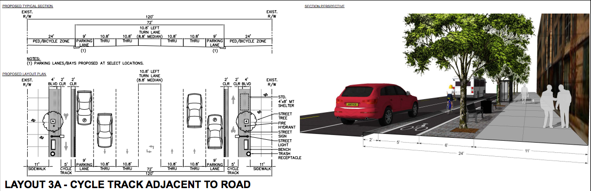
Source – Hennepin County
Although this scenario is arguably the best option that could have been chosen for the historically tortured corridor, I couldn’t help but think what the outcome would be if the Hennepin County chair members swayed one vote the other direction.
To their credit, it was likely that many referred strictly to the model numbers and figures found in the Operation Analysis document, completed in late April earlier this year, and felt worried that a redesign with smaller lanes would spell a traffic disaster. The report, a very well done but bone-crushingly technical 73-page epic, analyzes current and future traffic projections along the entire Washington corridor from Hennepin Avenue to Interstate 35W. The report spells out potential scenarios for redesign, and takes into consideration many outcomes based around the attempt to predict to-the-minute behavior 25 years in the future.
The report is well done according to traditional traffic engineering standards, followed all recommendations that Hennepin County provided, and abided to all under-spoken standards that encapsulate an analysis like this. The problem is, the “traditional” traffic engineering method is a relic of the past, when all that was seen was automobiles – automobiles everywhere.
I took it upon myself to investigate what the outcome of the analysis would be if two main assumptions were changed.
First, the 0.5% annual growth rate for traffic that Hennepin County recommends matches early-1990s trends at best. This also follows a nationwide tradition of predicting traffic very wrong. To change this, I used a 0.2% annual growth rate based on an old Metro Transit comprehensive plan completed by Mark Filipi. In my opinion, the 0.2% rate is also conservative, but to restrain the urbanist within me for the exercise, I found it to be a reasonable number in the analysis. And who knows, maybe some people will drive more than current trends in the next two decades.
Source – DC Streetsblog. Okay, we get it… people are driving less. Sheesh.
Second, instead of using the seemingly massaged traffic counts seen in the report, I used City of Minneapolis numbers directly from their traffic management database. It was previously found that the AM peak period counts in the report were 10% – 35% higher than those in the traffic database. In a similar fashion, the PM peak period counts were 8% – 46% higher than those in the traffic database. Reason? It is a common traffic engineering standard to round counts up.
To analyze the traffic, I used software called Synchro, which is commonly listed as a go-to analysis tool by many traffic engineers. To use and analyze data with Synchro, I designed the Washington Avenue corridor from 1st Avenue North to Portland Avenue South with appropriate lanes and block length dimensions. According to the report, the PM peak period is the critical design time span, so I applied those counts to the corridor for this exercise.
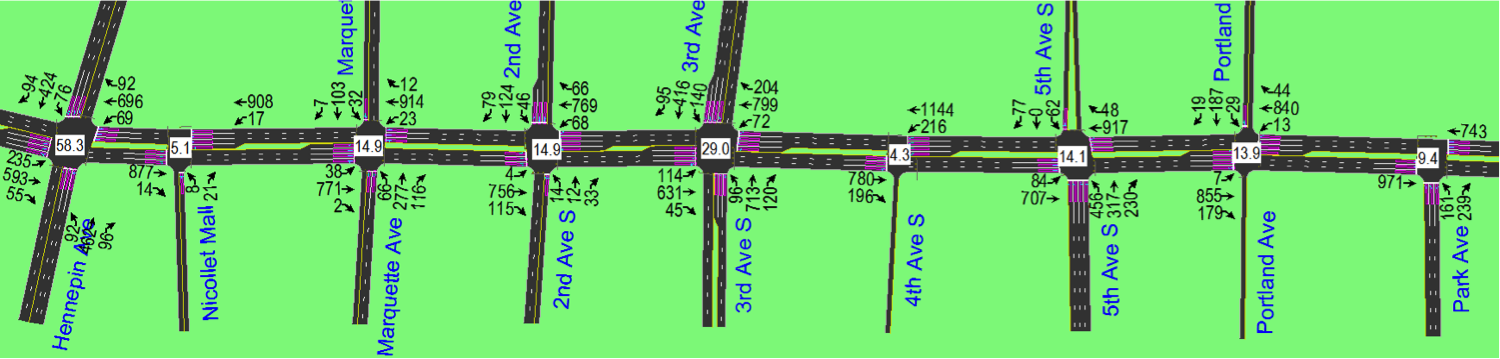
Example of Synchro used in one scenario. Its like real world SimCity, but with way more numbers.
I created several potential redesign scenarios for my full report, but to cut to the chase (you’re welcome), the most important finding in future projections was that the layouts recommended in the report were potentially over-designed – meaning that vehicle lane capacity was higher than it needs to be in the year 2035. Although this seems like a no-brainer considering the notion that more projected vehicles cause more projected congestion, it is an important finding.
After the scenarios were created, one stuck out of the bunch like a rollover truck blocking a freeway lane. This projected future scenario, set for the year 2035, lists a 4-lane Washington Avenue design with some protected left turn lanes but zero protected right turn lanes. The scenario also assumes a 10% reduction in PM traffic due to the new northbound Interstate 35W onramp at 3rd and 4th Avenues that will likely relieve congestion in the downtown grid. Long story short, the report found this scenario to be ineffective, and still recommended protected right turn lanes throughout Washington. Using my analysis, however, the zero right turn scenario allowed projected traffic to move at a Level of Service of C or higher at all intersections, which is usually sought by traffic engineers during a redesign project.
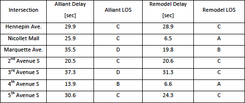
Note the Level of Service (LOS) values for each intersection. In the remodeled case, all intersections perform at a LOS of C or higher.
So, what does this all mean? Well, at this point in time for this specific project, a big pile of nothing goodness. As stated before, the Hennepin County board approved the design for six blocks of Washington with four lanes, and the City of Minneapolis will likely approve of the design in March. However, there are some important things to consider:
- Why do so many traffic engineers still insist on using annual projection traffic values that severely overestimate true demand for a corridor? Well, much of it likely retreats to the classic notion of “We’ve always done it this way” and “We are following traffic standards”. This mentality must change in the traditional traffic engineering field to accommodate 21st century transportation trends, especially in downtown areas like Minneapolis where so many transit and non-motorized projects are located.
- Why do we predict estimated intersection delay for vehicles to the nearest second, while planning for a corridor design 25 years into the future? This mentality probably worked in the so-called golden age of highway design, but should change to match probable future technology implementation. In 2035, will we see large-scale autonomous vehicle deployment? In 2035, will we see a larger urban population base that chooses to walk, bike, or take transit on a regular basis?
- The Hennepin County Board approved this on a 4-3 split vote. If one board member felt especially punchy that day and decided to vote the other way, Washington Avenue may have ended up as a STROAD like its current form, which would be disastrous for the neighborhood. Again, this begs the question… Why does Hennepin County have to control a corridor that should be an exclusive Minneapolis problem?
- Seriously, what is with the obsession with protected right turn lanes? I understand that they help with intersection delay, but really do not impact it much. These right turn lanes may end up affecting the cycle track design – lets hope a good bikeway design is implemented along Washington.
Of course, my “more-of-a-thought-experiment analysis” is a nice example of bad engineering, as I ignored any traffic count rounding standards and balances. I also did not design Washington past 5th Street South, and instead focused efforts on the corridor that will be reconstructed in 2015. There are also many unlisted notions that are often used in analysis, including the use of multiple software programs aside from Synchro to double-check intersection performance. Take my values and analysis with a large, boulder-sized grain of salt.
Still, it is interesting to see that altered traffic assumptions, including lower projected traffic growth values, impact corridor performance that significantly. I believe engineers should carry apply this idea toward future redesign projects, especially those located in urban corridors; this sorta-study sorta proves it.
(If you wish to see a copy of my full report, you can comment below and I can send you one… if I am feeling nice.)