
![]() Note: This post is part of the streets.mn/Nice Ride crowdsource conversation, a series of crowdsourced looks at how to expand or improve Nice Ride planning.Check out the rest here.
Note: This post is part of the streets.mn/Nice Ride crowdsource conversation, a series of crowdsourced looks at how to expand or improve Nice Ride planning.Check out the rest here.
Back in earliest September, NiceRideMN and Streets MN put forth a call to interested parties to provide “analysis and recommendations for the evolution of the Twin Cities bike share system”. The original announcement talked about data analysis, which caused my wannabe data geek ears to perk up. So I downloaded the NiceRideMN data, harassed some people on Twitter to get weather data (thank you again, @MorningWXGuy!), and plunged into the first steps of what I wanted to be fruitful analysis. Then I went to the project kickoff meeting.
At the kickoff meeting, the first thing I noticed was that almost everyone seemed to prefer the Fulton Ringer. The second thing was that Nice Ride’s operating model was different than I had always assumed. Nice Ride recognizes three general types of station – member/transportation, walk-up/recreation, and equity (which is really a whole other domain that exists across membership and walk-up, but more on that later, maybe). And some of the recreation stations have an outsized (positive) impact on revenue with a very low balancing requirement (presumably due to the fact that most riders from those stations rode in a loop and returned the bike to the same station it had been checked out from). The third thing was the realization that Nice Ride had already been over its own data with several different fine-toothed combs, and that any further attempts on my part to suss needles from the data haystack would likely be of little benefit.
So I rode home and pondered ways to answer some part of the project’s Seven Questions without getting all geeked-out on data. As I neared the end of my second week of pondering, Bill Lindeke posted an article on Streets MN in which he mashed-up disparate data sources and raised interesting questions. He overlayed a map of Nice Ride station locations on a map of Federal bike counts from 2010 to show places with higher bike counts that did not have NiceRideMN stations. He made a couple good points in the post (he always does, though?), but he did not rely on fine-grained data (for example, how many bikes left the Nokomis station on July 17th, 2014). He used higher-level data to arrive at reasonable conclusions. And that was the main thing I took away from the post: What about using maps instead of fine-grained data?
Enter the Strava Global Heatmap.
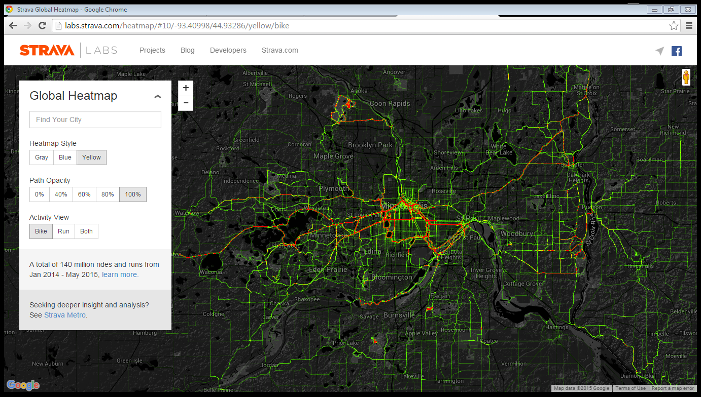
From the looks of it, the Strava Heatmap is not crude. It shows exactly where people are riding, and helpfully color codes segments based on frequency and total number of rides.
Now, the first thing many bike data people will say is that Strava is skewed toward riders with smartphones or other disposable-income gadgets, and as such it doesn’t reflect the full truth on the ground. In other words, people are riding in lots of other places, Strava just doesn’t see it.
For the most part, I concede that they are right. But for the purposes of this post, I argue that it doesn’t matter. All we need to see is general info on where people ride, and this map does that quite well.
See the bright red circles around the lakes in Minneapolis? The bright red squiggles at mountain bike favorites like Murphy-Hanrahan, Elm Creek, Lebanon Hills, and along the Minnesota River Bottoms? The bright red lines along the Cedar Lake / Midtown Greenway / Grand Rounds trails? People are riding in all those places, and at higher rates than in most other locations…
Here’s where the mashup got going. I recalled from the kickoff meeting (and from the 2015 5 Year Assessment Report) that one of the most revenue-positive stations (that also has an impressively low balancing requirement) was located on the north-east corner of Lake Calhoun (sorry – Bde Maka Ska). That’s right where Strava data shows a lot of people riding.
And looking at the Strava heatmap a little more, with my westerly-suburb-tinted glasses, I could see another lake where it seems a lot of people ride: Lake Minnetonka (aka. “great water” in Dakota; no new name needed). Hmmm, I wondered, could it be possible to drop a station or two somewhere near there?
Certainly not. The loop around Lake Minnetonka is roughly 21 miles, considerably longer than the 3+ mile loop around Calhoun or even the 7 mile Calhoun – Harriet loop. And even though well more than half of it is on beautiful trails, the remainder is on suburban roads with speeding cars. And it is completely separated from the main body of Nice Ride stations. So, it’s not going to happen.
But what if there was a new bike trail slated to open at the end of 2016 that would allow loops of between 5 & 7.5 miles on the eastern end of the lake? (Spoiler: there is.)
And what if those loops touched areas with relatively abundant parking? And, what if those loops also had destinations (restaurants, shopping, and of course the lake itself)? What might that mean?
The image below shows three potential station locations (light blue dots near the intersection of Highway 101 and Minnetonka Blvd, at a park & ride along Minnetonka Blvd east of 494, and in downtown Wayzata) as well as the new bike path (a light blue line paralleling Highway 101 as it crosses the Gray’s Bay causeway).
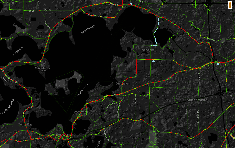
With stations so located and using the new trail and existing trails and streets, it could mean another high(er) revenue station or two that might not need to be balanced too much. It could mean that we had potentially identified a “destination outside the “dense grid zone” where isolated bike share stations can work with high utilization” (Question 3). It could even mean that 5-10 new stations could be placed around the entirety of Lake Minnetonka, starting with 2-3 stations in 2017 (Question 6) and be successful. And (this will be another post), it could be leveraged to help identify “new tools and approaches that Nice Ride should explore to make it easy for more people in Minnesota to choose active transportation” (Question 7).
Just an idea.