
Since using MapMyWalk in 2009 to log a dog walk, I’ve been hooked on mapping my movement. I like knowing the number of miles I’ve clocked and looking back on all of the neighborhoods I’ve explored on the map. Over the years, I’ve used various iPhone apps and one by one they’ve fallen out of my favor for one reason or another. What they each had in common was the need to remember to start and stop the app at the beginning and end of a walk. There were countless walks in which a mile in I’d realize I’d forgotten to start the app. Or I’d forget to stop tracking after boarding a bus to go home and my map would be ruined because the app didn’t recognize that I was no longer walking.
This all changed when I saw my friend Brian’s tweet:
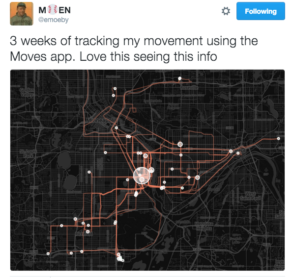
Tweet from @emoeby about Moves App
Moves App
Immediately after realizing the Moves App would solve my start/stop tracking issue and that it would recognize the difference between walking, running, biking, and transport (bus, train, car, etc.), I downloaded the app. I now have more than nine weeks of data and I’ll share with you how I’ve been using the app and the data made available. I should note that my personal experience is with the iPhone version but the app is also available for Android devices.
But first, I asked my friend Kyle to share some of the technical aspects of how the Moves App has evolved:
“Shortly after Moves App came out, it did much of what it does now, but if I remember correctly it relied entirely upon the GPS chip inside your smartphone, which is probably the biggest battery killer for phones. So, even though the data was fascinating, it simply wasn’t feasible to have this app tracking your movement all day, when it killed your battery by noon. The biggest upgrade in functionality occurred with the release of the iPhone 5S, which was the first iPhone to have a chip dedicated to step tracking in it. So, instead of using GPS data to capture where and how much you moved 100% of the time, Moves was updated to take advantage of this new chip, which meant that when you weren’t moving (which really is most of your day, especially for us office workers), it used effectively zero battery, and then when you walked, drove, biked, etc., it fell back on the GPS tracking which was more accurate. So, while it certainly used more battery than if I had it fully turned off, this new mode meant I could both track my movement and make it through a whole day without the battery dying.”
Summary Bubbles
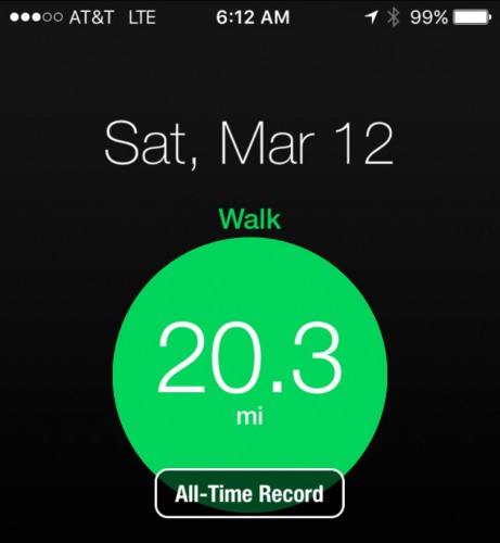
Summary bubble showing all-time record achieved
Green (walking), pink (running), and blue (cycling) bubbles appear at the top of the screen and by tapping on the bubble, you can see your steps, miles, and time spent doing that activity. The size of the bubbles grows as you spend more time doing that activity. While the green walking bubble appears as a default and will show 0.0 miles at the start of the day, the running and cycling bubbles only appear after engaging in those activities. When you’ve achieved a personal best for an activity, “all-time record” displays over the bubble.
Storyline
In my opinion, the storyline is what sets Moves App apart and makes it much more than a pedometer. It is a diary of the places you’ve been and your mode of travel in between. In addition to walking, running, and cycling, it tracks transport.
You can click on a place in your storyline to edit the location if it has “snapped” to the wrong location or is unknown. If a place you’ve been isn’t available, such as a friend’s house, you can create a custom label for the place. After you’ve assigned a place once, the app will recognize where you’ve been and automatically use that place name.
In the example below, I walked a total of 10 miles throughout the day and took a 1.4 mile bike ride. I also edited the default “transport” to specify the bus, train, and car segments of my day. I’m including this long image to show an entire day of activity.
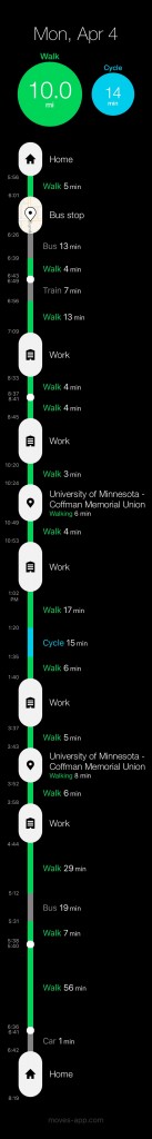
Moves App Storyline
You can select a segment of your storyline to drill down for more information. So, let’s say I take a sunrise walk by myself, then take a sunset walk with my husband. Before Moves App, all my walking data is in one lump sum. Now I can zoom in on the walk we took together to tell him the stats, including duration of the walk, start and end times, distance in both steps and miles, and average speed. How romantic!
Notifications
You can choose to receive notifications of all-time and past month records as well as daily and weekly summaries. For me, this has been motivating, especially now that I’m participating in 30Days of Biking and am accumulating cycling minutes and miles on Moves.
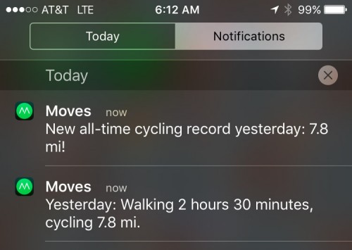
Notifications of an all-time record and a summary of activity from previous day
Export Moves Data
In my opinion, one of the best features of the Moves App is the ability to export your data. With a click of a button you can download a zip folder containing the following file types: csv, geojson, georss, gpx, ical, json, kml, and kml_ge. I currently use the kml zip folder, which contains files for activities (walking, running, cycling, and transportation segments), places, and storyline. I have only used the activities files as imported layers on custom Google Maps.
Here are a couple of examples of how I use exported files:
- Map images for my walk recap blog posts including the Beer Walk: Wabasha Brewing Company for streets.mn.
- Map of the hikes and bike rides I take with my friend Julia as we log miles toward Department of Natural Resource’s 125 mile challenge. We will also test Moves App’s ability to track our boat miles when we hit the St. Croix in a kayak or canoe later this spring or summer.
Connecting Moves App with Other Apps
As explained by Kyle, “Moves has an app ecosystem of its own, with an API that other applications can tie into to capture the Moves data with interesting results.”
Move-O-Scope
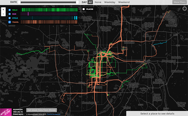
A map from Move-O-Scope displaying 9 weeks of Moves App history
The app that Brian used to create a map summary of three weeks of movement is Move-O-Scope. After following a set of detailed instructions on how to connect the two apps, you can view a summary of your walking (green), running (pink), cycling (blue), and transportation (orange) on a map. It also displays places you’ve been as white circles. It’s easy to visualize where you spend most of your time as well as your most popular routes.
Here are a couple of ways I use Move-O-Scope:
- Filter out the cycling routes I take in April for 30Days of Biking!
- Determine places I’d like to explore. Because I’ve only been using Moves App since the end of January 2016, there are huge gaps that I’m excited to fill in with green, pink, or blue lines.
If you’re the kind of person who likes to track your activities throughout the day and you have an iPhone or Android phone, I recommend installing Moves App to help you visualize where you’ve been and how you got there. Then connect Moves App to Move-O-Scope and see your map glow in green, pink, blue, and orange.
Potential Concerns: Privacy and Battery Life
Something to be aware of is that the Moves App was acquired by Facebook in 2014 and around that time there were a number of articles written concerning Moves App changing their privacy policy. Whether or not you’re okay with the terms is up to you.
Additionally, the Moves App does take a decent amount of battery power (15% in the last 24 hours for me). I’m OK with this and charge my phone every night and have a phone charging case with me most of the time.
For me, the pros outweigh the cons and I’m hopeful the app will stick around long enough for me to celebrate walking every street in Minneapolis (and maybe St. Paul too!).
Let’s Hang Out in the Comments
- Do you currently track your activity?
- Yes? What do use and what do you like about it?
- How do you think tracking your activity changes the way you interact with your environment?
- Has activity tracking changed your behavior?