One of my first articles for streets.mn was on Bloomington’s Four Lane Death Roads, (four lane undivided roads) written in response to Bill Lindeke’s introductory article on Four-Lane Death Roads. Four years later it’s time to revisit the subject with updates and additional background material.
The Problem With Death Roads: Conflict Points
Imagine a typical trip down a Death Road. You’re driving down the right lane. Pretty soon there’s a bus stopped or a brave, fearless bicyclist in the lane, so you move into the left lane. Then a car is at a dead stop waiting to make a turn, so have to move back into the right lane. But stopping in a traffic lane to turn is a good way to get rear ended, as well as causing friction and other motorists to make abrupt lane changes, another way of inviting crashes. Plus the motorist waiting to turn is going to get anxious, fearing being rear-ended if he stays their to long, so at the slightest break in traffic s/he guns it, hopefully not hitting any cars or pedestrians in the process.
Engineers like to talk about “conflict points”, where two motorist might try to occupy the same place at the same time. A Death Road doubles the conflict points for through movements at an intersection.
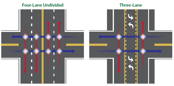
Death Roads also double the conflict points for turning movements. Red is through traffic and blue is turning traffic. You can see at the bottom left the motorist in the red car moves out of the left lane to avoid the blue car that is stopped in the through lane to make a turn, potentially hitting a car in the right lane Father up the diagram you see a motorist going s could rear-end a motorist stopped to turn in either direction on the through lane. At higher volume intersections a right turn lane is appropriate to remove a further conflict point.
The Problem with Death Roads: Sight Distance
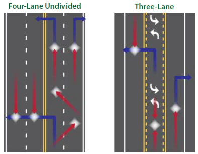
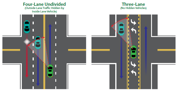
Another problem is with turning traffic: a car in the left lane can block the view of a car in the right lane from a motorist waiting to make a left turn.
After writing the original article, the inevitable happened: a pedestrian fatality on 86th Street and Nicollet Avenue. The driver of a southbound Xcel Energy truck going straight tried to make an evasive maneuver to avoid a northbound left turning car that failed to yield, but instead wound up losing control and plowing into a signal pole on the southwest corner, knocking it over. A man that was just standing there on the corner pork chop island waiting for a bus was buried under the whole mess. As typical once the scene was cleaned up and the next dramatic story came about the news media stopped reporting on the investigation, so we don’t really know what happened, but I strongly suspect it was the sight distance issue (there was another car waiting to make a southbound left turn)
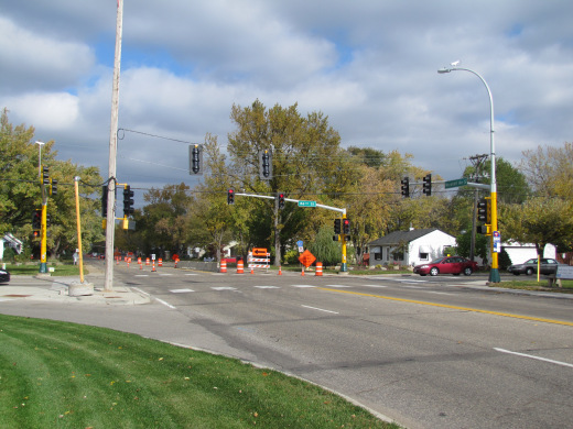
The scene of the crash, note the temporary traffic signal to replace the destroyed pole.
Of course this particular fatality could have been prevented by putting the bus stop in a better location (and it has in fact been moved to the near side) but it illustrated the problem with Death Roads in particular. Pedestrians are vulnerable almost the full length of Nicollet Ave due to the sidewalk being right next to the curb with no boulevard and no shoulder. It’s only a matter of time until a texting or drunk driver jumps the curb and hits another pedestrian.
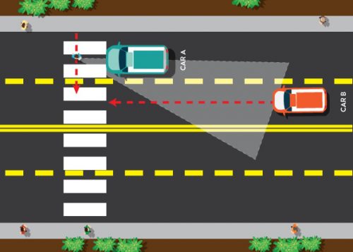
The Problem with Death Roads: Pedestrians Crossing Multiple Lanes
With multiple lanes, a motorist in the right lane will stop for a pedestrian. A second motorist coming in the left lane may not see the pedestrian because s/he is blocked from view by the yielding car. This type of crash is called a Double Threat. There have been several fatalities due to this in the state recently.
Solutions
Obviously the best solution is to get rid of Death Roads entirely. Convert the road to three-lanes, or even two in a “road diet”, or if that is not possible due to high traffic volumes, add a center turn lane to make a five lane road. This doesn’t mitigate the sight distance issue, but does eliminate some of the conflict points between vehicles. The threshold between roads that need lanes removed vs a lane added is variable and disputed. Numbers given without unduly delaying people in cars range from 10,000 to 20,000+ vehicles per day in various studies. The FHWA (Federal HighWay Administration) suggests the following volumes:
Under 10,000: Great Candidate in Most Instances.
10,000-15,000: Good Candidate in Many Instances
15,000-20,000: Good Candidate in Some Instances
20,000+: Feasibility Study Required, Some Successes By Some Agencies
Factors such as heavy volumes of turning traffic increase that number. Eventually you wind up with so many motorists stopped to make a turn that you only have one usable lane each direction anyway. Numerous traffic signals and stoplights decrease that number, because you’ve substantially increased the queue length for through traffic. Unusually heavy peak use also decreases that number. In Minnesota, 15,000 vehicles per day has been the de facto upper limit, due to a state funding rule that requires two through lanes be provided at that level unless a traffic study proves that it will operate with acceptable level of service with fewer lanes. Generally, a full traffic study is outside the scope of routine mill and overlay projects.
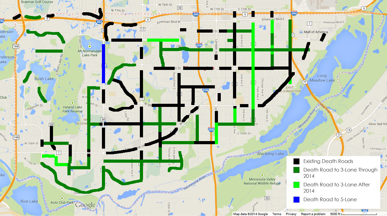
Some Successes and Failures in Bloomington
At the time of my first article, the road diet policy (also known as “traffic calming”) was strictly limited to collector streets. But there were plenty of arterial streets under the magic 15,000 number where a road diet is generally considered workable in Minnesota. The only Death Roads above 15,000 vehicles per day were Old Shakopee Road between Normandale Avenue and France Avenue, and Normandale Avenue near I-494. That part of Normandale Avenue has since added a median and left turn lanes (as well as off-road trails for bicyclists), and the city has in some cases road-dieted arterials.
UPDATED MAP:
The Portland Avenue project, led by Hennepin County, was a significant development. There’s still some old, grumpy Bloomington residents who feel it’s their constitutional right to be able to drive down Portland Avenue at 50 mph 24 hours a day, even if more pedestrians are killed and bicyclists are limited to the sidewalk. They made their presence known in the public meetings, so I made sure to show up to show my support for the project. Ultimately the road diet happened. Here are some before and after photos across from Valley View Park, home of a large number of ballfields and the municipal swimming pool.
Portland Ave Before

Portland Ave. After
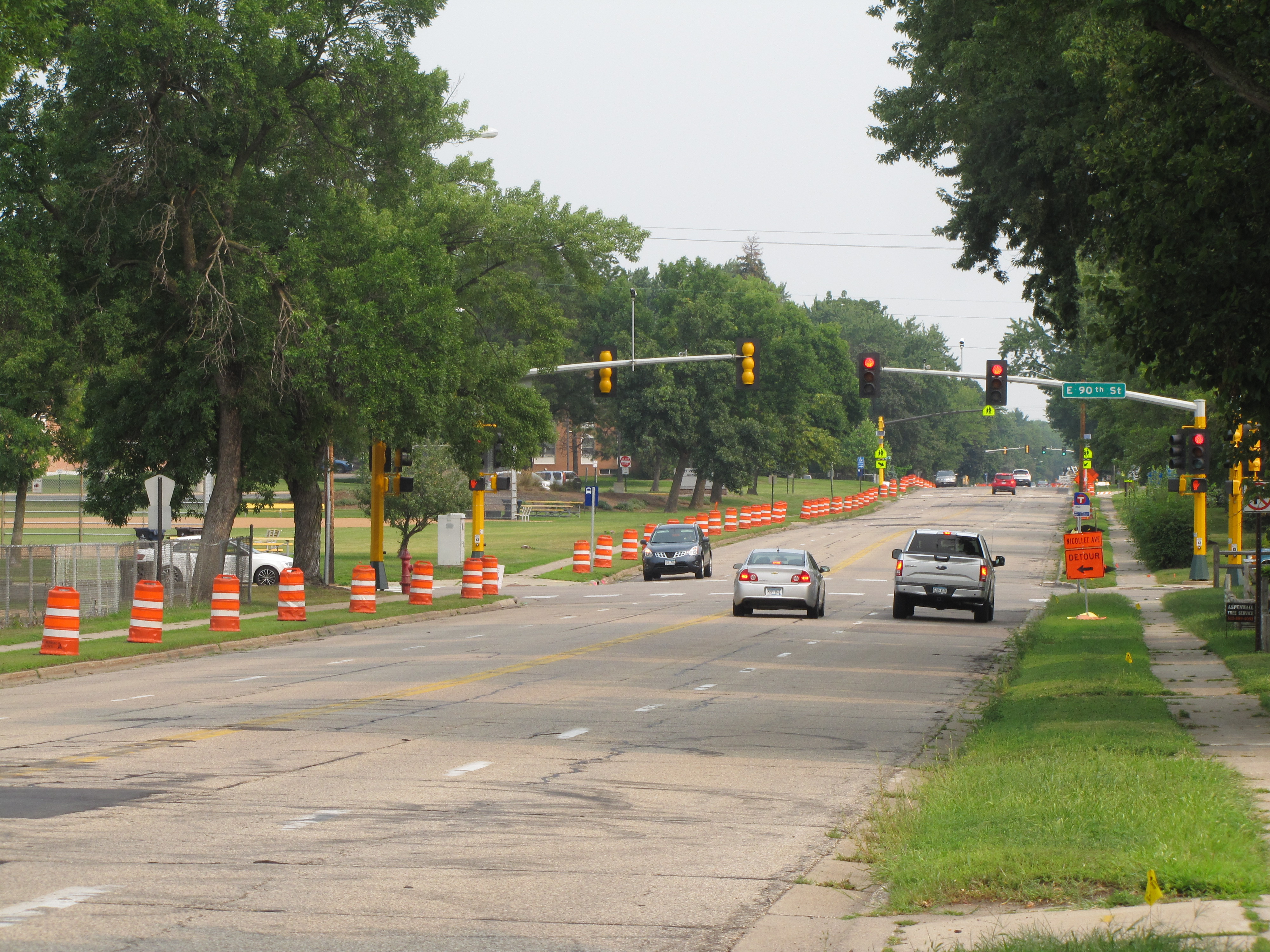
As a potential encore, we have Nicollet Avenue, which even has some existing 5-lane sections. A mill and overlay is required this fall due to to Centerpoint gas main work, and the idea for doing a road diet didn’t occur to them in time to do the study, so it will remain a death road for now. But if the results of a traffic study are favorable, they might actually grind off the new markings and restripe it as soon as next summer.
At the same time there’s been some failures. Lyndale Avenue south of 102nd was redone with three lanes, but north of 102nd was redone as a Death Road. Responses I got from the engineer were “there’s more traffic near 99th” and “the bicycle lanes wouldn’t connect with anywhere”. This despite already having been identified for an on-street bicycle facility in Bloomington’s alternative transportation plan. And I guess connecting the east-west bicycle shoulder system to a major business district isn’t “anywhere”. Portions of 90th and 94th streets have been also mill and overlaid and stayed Death Roads.
As for 106th Street, this is a special case. A traffic study concluded that due to peak volumes, two eastbound through lanes are required despite overall volumes being below 15,000. Meanwhile the upcoming I-35W project should have provided an opportunity to reconfigure the road. The FHWA is also requiring two westbound lanes at the interchange so that a double left off northbound I-35W ramps can be added in the future if needed. The attitude of the city seems to be “if we need four through lanes, and a traffic study shows that we don’t need additional turn lanes, why build them?”. So we’re stuck with a 1960s Death Road design here.
Beyond Road Diets: Building a Better Bloomington for Bicycles
As good as road diets are, the limitation is there are quite a few bicyclists who still not use the new shoulders, either sticking to the sidewalks, or just not riding at all. I don’t blame them for wanting more than a thin layer of paint separating themselves from motor vehicles. To the extent I bicycle around Bloomington at all, I won’t ride the shoulders, sticking to the sidewalks myself. In Bloomington, it seems the vast majority of bicyclists of all ages still ride on the sidewalks on both Death Roads and dieted roads. We need to do better by building more off-road paths in future projects. We also need to start fixing problems with our sidewalks, but that’s a topic for a future article.