
A Michael Birawer painting of “downtown Saint Paul.”
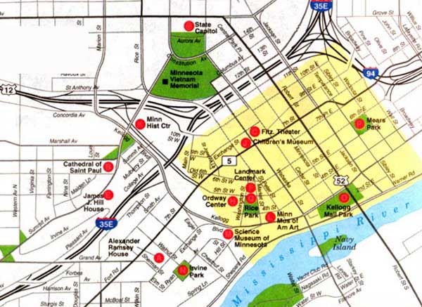
 Maps of “Downtown Saint Paul” are pretty consistent. They almost always depict a small slice of historical urban density, edging a river, and firmly enclosed by a ring of freeways on all sides. The end result is a downtown that is small, quaint, and looks nice in photos taken from a distance. Downtown Saint Paul is decidedly not, however, a large, vibrant, gritty, urban downtown. As maps make it clear, Saint Paul is too small for that. The name Paul literally means “small”, after all.
Anyway, the maps are mostly the same. As an experiment, I unearthed a bunch of maps of downtown Saint Paul and plotted them over each other in Google.
Here are the results:

(You can play around with them yourself.)
The “downtown” areas of each of the map examples, arranged from smallest to largest:
- Downtown “core” map — .46 sq mi.
- Official City Map – .53 sq mi.
- Downtown Saint Paul parking map — .68 sq. mi.
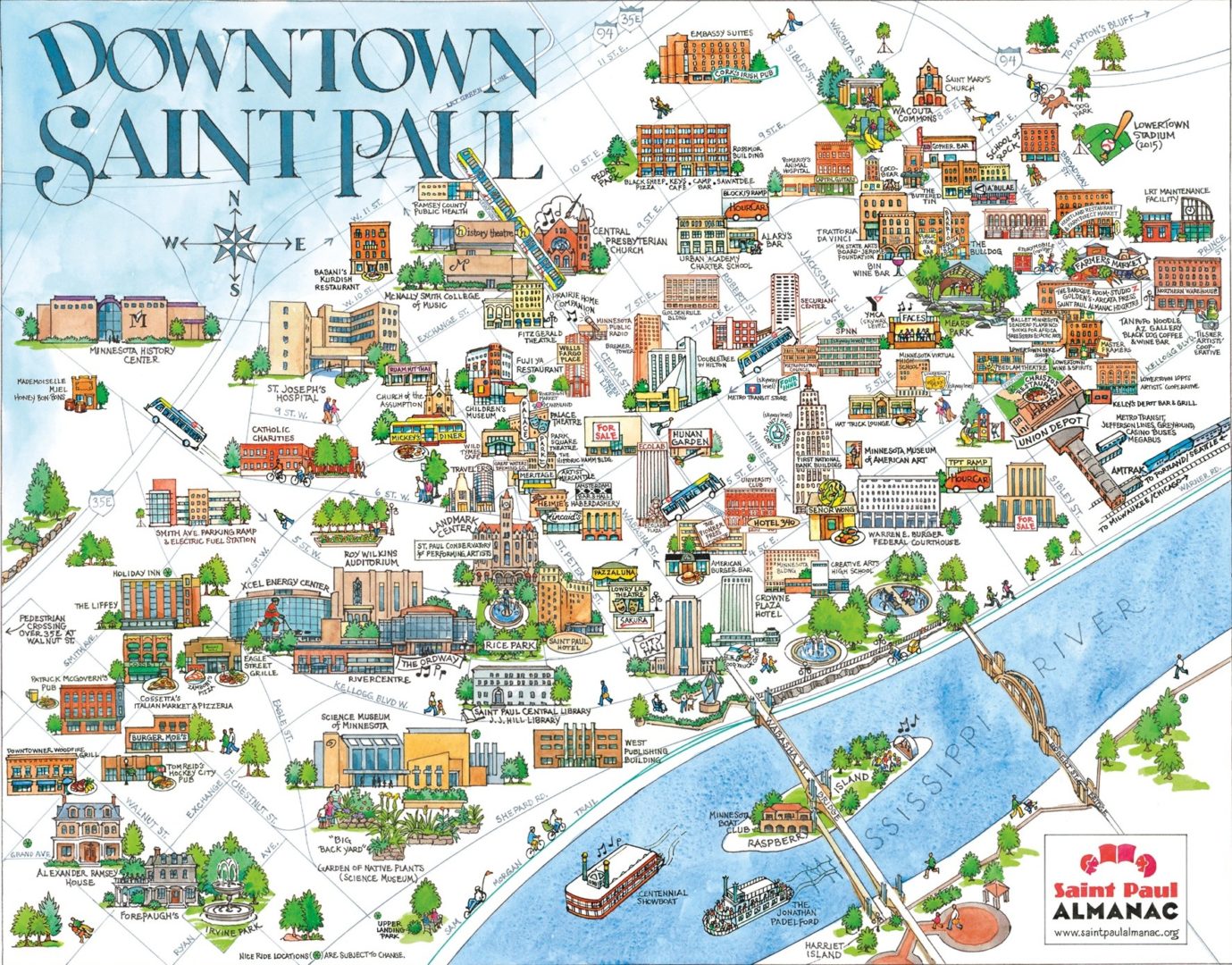
- Saint Paul Almanac (hand-drawn Avidor) Map – .78 sq. mi.
- Downtown Alliance map (scroll down on the About page) — .81 sq. mi.
- Google Maps map – .991 sq. mi.
As you can see, downtown Saint Paul is small, less than a square mile in total area.
But wait, there’s more…
There’s one map of downtown Saint Paul that I really like, because it offers such an exception to the other downtown maps. It’s the Metro Transit “downtown zone” map of Saint Paul, showing the area where you can travel by bus for a mere 50 cents.


East 7th and Maria Street, the eastern end of the “Downtown Zone.”
Here, by contrast, downtown is more expansive. In this map, the “downtown” encompasses everything from Metro State, up on the East Side bluffs, all the way west to the corner of Selby and Summit where the Cathedral towers over the city. On the other axis, downtown sprawls from the Rice and University light rail stop all the way south to Plato Boulevard, halfway into the West Side Flats. This territory is much larger, encompassing 1.18 square miles of land.
(If you connect the endpoints, as I believe you should, and add in some of the more ambitious connections from the various maps, you get a maximum possible extent where Downtown Saint Paul includes over 2 and a half square miles, five times the size of the smallest map.)

A more historic conception of “Downtown Saint Paul.”
I love the expanded idea of downtown, and believe that it reflects a historical character of the city, where downtown was larger, denser, and more seamlessly linked to the neighborhoods around it. To me, a more expansive concept of downtown offers a terrain that reflects the historical scope of what downtown Saint Paul might have felt like a hundred years ago. Then, the bustle, density, and cosmopolitan character of downtown would have extended gradually up into the neighborhoods in the surrounding hills and over the river.

The view from the site of the Cathedral in 1905, where density stretched seamlessly into downtown.
For example, one of my favorite views of the city is from the steps of the Saint Paul Cathedral, which sits like a candle on a birthday cake overlooking the valley where downtown is cradled by the river bluffs. Before about 1930, this entire area from the Cathedral to Rice Park was a dense thicket of apartment buildings and mixed-use, with apartments, commercial stores, and even industries like the Purity Bakery. They were all all densely packed in these blocks between the downtown core and the Cathedral, along narrow streets that zigged and zagged back and forth. Downtown extended to the foot of the Cathedral and through “seven corners” , and the whole area was full of people, density, shopping, and parks.
So too with the West Side Flats, where Robert and Wabasha streets were lined with commercial and industrial properties, and a tight network of streets was full of dense and diverse homes for thousands of people who were mostly new immigrants from all over the world. (My great great grandfather was one of them, and worked at a mill on Robert.)

The view from the bluffs on the West Side, showing the Flats before they were bulldozed. Density connected seamlessly up Wabasha Street into downtown.
Before the war, you would have found mixed-use density on the east end of downtown as well, where the Lafayette Park neighborhood lay, near where today Highway 52 rams into West 7th Street and the empty husk of the original Red’s Savoy pizza sits empty, on the far side of the Saints ballpark. So too with Seven Corners, which I’ve written about here before.
And finally, there was a lot more density around the State Capitol, which up until the 1930s and 1940s was surrounded by homes and apartments of every conceivable stripe. I’ve written about this before, and it’s something that I think about each time I take the Green Line past the capitol dome or bike up Rice Street from downtown proper.


The edge of downtown Saint Paul, before and after the Capitol and freeway demolitions.

Kellogg Boulevard is literally labeled as a “divided highway.”
What happened to downtown Saint Paul was a tragedy of shrinkage, bulldozing, and misguided planning. On all sides, the once-dense edges of downtown were erased from the map. The first to go was the State Capitol area, where bulldozers began demolishing buildings way back in the 1930s, sacrificed in the name of a Cass Gilbert sketch of symbolic green space. (Of course, these projects were also an excuse to demolish housing for poor people.) Today there is no trace of the hundreds of homes that once sat on streets surrounding the Capitol. Even the streets are gone, and instead the capitol area offers a mostly empty green space full of memorial plaques, parking lots, and grey office buildings that are deserted by 5 pm. Needless to say, few people live there. The freeways, industrial parks, and empty green spaces came through and essentially ringed the remnants of downtown Saint Paul in a neat little noose, where it still sits today, cut off on all sides from the neighborhoods surrounding it.
Thinking about what the future holds for downtown Saint Paul, one fundamental step is to expand the scope of the conversation. I believe Saint Paul leaders should re-imagine a more connected and larger vision of downtown.
There are a few things that might make this easier:
- Completing the Capitol City Bikeway into and out of downtown.
- Taming, capping, or removing a lane from some of the freeways that cut off downtown from its former parts and the riverfront, especially Shepard and Warner Roads.
- Rezoning parts of the edges of downtown away from marginalized and undervalued industrial land to more mixed-use urban uses. This is especially important in the West Side Flats and the Lafayette Park area (west of Railroad Island).
- More aggressively working with the Capitol Area Architectural and Planning Board (which controls zoning and land use decisions in the large Capitol area) to encourage density and walkability around the Capitol.
- Traffic calming, slowing speeds, and narrowing dangerous arterial streets, especially Kellogg, Plato, Robert, Pennsylvania, Marion, and East and West 7th.
- Removing superfluous and dangerous freeway connections, like the off-ramp at 10th Street (west), the on-ramp at 10th/Wacouta (east), the ramp at Wall Street (east), and a few more.
- Removing the fifth traffic lane on the Robert Street bridge and striping a bike lane instead.
As you can see from this list, I believe the key to expanding the scope of downtown Saint Paul lies in growing the walkable fabric of downtown. If people can easily walk to and from the downtown core, they might live, work, eat, or shop in the areas around downtown. If they can’t, they won’t.
There are lots of ways to do this, but if we continue to limit our conception of “downtown” to just the part that is bounded by freeways, we’ll be selling Saint Paul short. The city was once much bigger than that, and it should be again.