For several decades, railroads have abandoned many miles of track in the United States due to several factors including redundant routes, bankruptcies, mergers and significant government investment in roads that made shipping freight by rail less competitive than by truck. While some railroad right-of-ways have disappeared from redevelopment, others have been converted to trails that can be easily built and easy to use due to their flat grades and typically fewer road crossings. This has certainly been the case in the Twin Cities region, where several abandoned rail lines have been repurposed for trails. This post will go into detail about the history of some of them. Information about these trails and the former rail lines is to the best of my knowledge.

In a separate post, I will go into detail on rails-with-trails – trail segments that are along active rail lines such as the Luce Line Trail east of Plymouth, which follows along active tracks owned by Union Pacific Railroad. This post only pertains to trail segments that utilize abandoned railroad right-of-way with no active rail line next to it. Note that some of these right-of-ways may be repurposed for other modes of transportation such as bus rapid transit, light rail, regional rail, or (extremely rarely) reopening freight service.
Midtown Greenway
Before it was the Midtown Greenway, it was originally part of the Milwaukee Road’s mainline between Chicago and the Pacific Northwest. The rail line was built in 1882, and thirty years later the Milwaukee Road grade-separated the rail corridor in a trench to significantly reduce conflicts with street traffic in South Minneapolis. In addition to freight trains, there were also passenger trains passing through the trench including the famous Olympian Hiawatha. In 1971 scheduled passenger service on this route ceased, and nine years later the Milwaukee Road abandoned its route through Montana and the Pacific Northwest due to financial trouble. In 1986 the Soo Line purchased the Milwaukee Road, and five years later a short-line railroad named Twin Cities & Western (TC&W) was founded and took over most operations on this route. The TC&W serves farming communities in western Minnesota and South Dakota, and connects with the major railroads in the Twin Cities. In 1998 the rail corridor was severed near the intersection of Lake Street & Hiawatha Avenue. This was due to Hennepin County wanting to rebuild Hiawatha Avenue and for the Hiawatha Line (now called the Blue Line) light rail.
The rail corridor was still used for a few more years to serve at least one industry in South Minneapolis, but eventually it was fully abandoned. Planning and construction of the Midtown Greenway ensued over the next few years . The completed Midtown Greenway connects the Kenilworth Trail and Cedar Lake Trail on the west end with West River Parkway on the east end. In 2007 the Martin Olav Sabo Bridge opened, which provides a safe and grade-separated crossing for the Midtown Greenway over Hiawatha Avenue.
The Midtown Greenway is one of the most popular trails in the Twin Cities, as it’s excellent for both recreation and commuting. It offers a safe and fast way to bike through South Minneapolis without having to be on roads, which is a rarity in an urban area.
The Hennepin County Regional Railroad Authority (HCRRA) owns the land, and it’s likely a question of when, not if, transit is built along the Midtown Greenway. The bigger question is what it will look like. Some support a turf track streetcar line, while others support a double-track light rail line. For now it hasn’t been a high priority for Metro Transit and the Metropolitan Council, but sooner or later they will have to decide what this important transportation corridor should have, whether it’s streetcars, light rail, or perhaps even bus rapid transit.
Luce Line Trail (Plymouth-Cedar Mills)
One of several interurban (predecessor to light rail) lines built in Minnesota, the Electric Short Line, more commonly known as the Luce Line, was built in the early 1900s. In addition to interurban service, there was also freight service, which connected western Minnesota farming communities that weren’t served by the major railroads. Although the plan was to have the rail line go all the way to Brookings, South Dakota, the Luce Line only went as far west as the tiny Minnesotan town of Gluek. Contrary to its official name, the Luce Line was never electrified, and instead utilized gas-electric motorcars for interurban service and steam engines (later replaced by diesel engines) for freight service.
Due to financial trouble, the Luce Line was taken over by the Minneapolis Northfield & Southern Railway (MN&S) in the 1920s, and at that point was called the Minnesota Western. Interurban operations on the Minnesota Western ended sometime in the 1940s. In the 1950s the Minnesota Western was purchased by the Minneapolis & St. Louis Railway (M&StL), and the Minnesota Western became the Minneapolis Industrial Railway. The purchase and name change were intended to boost industrial development along the rail line. However, ownership by the M&StL was short-lived, as the Chicago & North Western (CNW) purchased the M&StL in 1960. For the CNW there was very little profit to be made in this lightly used branch line, so it was unimportant to them. In 1967, despite opposition from shippers, the CNW abandoned the segment between Gluek and Hutchinson, and in 1972 they abandoned the segment between Hutchinson and Plymouth.

The Luce Line Trail was one of the first rail-trails in Minnesota, with planning of the trail beginning almost immediately after the CNW abandoned the rail line between Plymouth and Hutchinson. Trail construction was completed on certain segments in the late 1970s and early 1980s. Today the Luce Line Trail goes between Minneapolis and Cedar Mills (the segment between Minneapolis and Plymouth isn’t on railroad right-of-way). While the trail technically continues west of Cedar Mills to as far west as Cosmos, it’s vegetated and would be very difficult to use a regular bike on it.
West of Cosmos to Gluek, most of the railroad right-of-way was plowed for farming. When the trail was being planned, there was opposition from landowners who questioned the need for a trail, feared trail users would trespass on their property and didn’t want their fields severed by the trail. There is almost no physical evidence of the rail line’s existence between Cosmos and Gluek.
Where the railroad bed still exists, there is very little physical evidence that this was once a rail line except for telegraph poles along rural parts of the trail, and a couple railroad-related signs that you can find along the trail if you look hard enough. If you go to Winsted you’ll notice the trail makes a sudden turn to go around Winsted Lake. There used to be a trestle across the lake, but in 1953 a derailment caused several railcars to fall into the lake and significantly damage the trestle. The original plan was to fill in where the trestle was with dirt and gravel, but instead they rerouted around Winsted Lake.
The Luce Line Trail is mostly intended for recreational use, especially in the rural area where walking and biking infrastructure is severely limited. For the most part the trail retains the flat grade and straight route of the railroad right-of-way, except a couple short segments in Hutchinson and a long one in Winsted due to the railroad right-of-way in that area being redeveloped. Based on aerial images, there used to be a significant gap in the trail in Winsted and no easy and direct way to get from the western end of Winsted to the eastern end. However, when I biked through there a few months ago it appeared that was fixed, though it does involve crossing a busy road.
Dakota Rail Trail
The former rail line, owned by the Great Northern Railway (GN), was commonly known as the Hutch Spur. Originally it branched off the GN’s secondary mainline (present day this is BNSF’s Wayzata Subdivision) in St. Louis Park and wound its way through Hopkins, Minnetonka, Excelsior, and St. Bonifacius before making a straight shot to Hutchinson. In 1899 the route between St. Louis Park and St. Bonifacius was replaced with a new routing between Wayzata and St. Bonifacius via Mound. Between St. Bonifacius and Hopkins the original route was abandoned, and even with old aerial photos it’s very difficult to see where it was as most of it has been redeveloped.
GN operated freight and passenger service on the Hutch Spur. There were only a few passenger trains per day, with most originating/terminating at the Minneapolis Great Northern Depot, but at least one originated/terminated at St. Paul Union Depot. Passenger service on this branch line was discontinued by 1960. A unique feature of freight operations on the Hutch Spur was a caboose built from a modified boxcar, and it was nicknamed the Hutch Caboose. The Hutch Caboose retained the large doors from when it was a boxcar to carry small freight, and it was a common sight on the Hutch Spur for several decades. The caboose is now part of a restaurant in Devils Lake, North Dakota.

In 1970 GN merged with a few other railroads and became Burlington Northern (BN). BN continued to operate freight service on the Hutch Spur until 1985 when they proposed abandoning the rail line. Shippers along the route sought a new railroad to takeover, and that same year a short-line railroad based in South Dakota named Dakota Rail took over operations. In addition to freight, there were a couple short-lived dinner train operations on the Hutch Spur in the late 1980s.
In 1995 Rail America Inc., a company which owns several short-line railroads, acquired Dakota Rail and continued freight operations until 2000. According to local railroad historians the last train on the Hutch Spur was on June 14, 2000, and it marked the end of rail service in Hutchinson. Another railroad was sought to take over operations, but there was low freight traffic on the Hutch Spur, which would make profitability very difficult to achieve. In addition, much of the railroad infrastructure was old and needed to be repaired or replaced, including the rails that dated from the 1890s. With no apparent interest from another railroad, the Hutch Spur was officially abandoned. For a few more years the rails stayed in place, and as a kid I was able to see the slow but sure disappearance of the rail line when my parents drove on Highway 7 through St. Bonifacius and Hutchinson.
In 2008 the first section of the Dakota Rail Trail opened, and the trail now goes between Wayzata and Lester Prairie. Although there are plans to extend the trail all the way to Hutchinson, there is opposition from property owners and snowmobile users. The trail is entirely paved and virtually follows the railroad right-of-way for the whole route. One challenge faced by trail users is getting across Shoreline Drive in Mound, which is a wide and busy road with only a painted crosswalk and a couple signs to indicate the trail crossing. This should definitely be fixed as it’s a major safety issue, especially in the warm months when there are many people using the trail. Besides that, it’s an excellent trail for recreation and offers some views of Lake Minnetonka. Even better is the ability to access this trail via transit; Metro Transit’s Route 645 parallels the trail between Wayzata and Mound (weekdays only; on the weekend the route terminates in Wayzata).
There is a lot of physical evidence of the railroad that once occupied this route, especially west of Mound. Many railroad-related signs including flange posts, whistle posts, and mileposts can be found. There are also many railroad ties that were thrown in the ditches along the trail, perhaps because they were rotted by the time the railroad was abandoned so it wasn’t worth salvaging them.


A few times in the past, there have been mentions of repurposing this railroad right-of-way for some type of transit, but as of now there is no official proposal. Considering the trail received opposition from landowners around Lake Minnetonka when it was first proposed, it’s likely any proposal for transit on this route would receive firm opposition (though I’d welcome being proven wrong). Due to the narrow width of the right-of-way between Wayzata and Mound, it’s likely the trail would need to be permanently removed for any transit alignment. While I don’t believe it’s worth reestablishing a rail line all the way to Hutchinson, I do believe that regional rail to Waconia is worth pursuing as long as there are good trail connections to the Luce Line Trail, which is a few miles or less from the Dakota Rail Trail between Wayzata and Mound.
Bruce Vento Trail
This route was part of the first rail line between the Twin Cities and Twin Ports of Duluth and Superior. Built in 1877, it was owned by the Northern Pacific until 1970 when they merged with a few other railroads to become Burlington Northern.
Sometime in the mid to late 1980s this rail line was abandoned between St. Paul and the southwest border of White Bear Lake, as it was deemed redundant. Just north of I-694 to as far north as Hugo, the rail line remains and is owned by BNSF, but only used by the Minnesota Commercial Railway to serve local shippers. Along the abandoned segment there isn’t a lot of evidence of its past use except a short section of track along the trail just south of County Road D in Maplewood.

In the near future this corridor will dramatically change with the planned Rush Line bus rapid transit service between St. Paul and White Bear Lake. Between Lake Phalen and Beam Avenue in Maplewood the trail will be alongside a busway, with buses running every 10-15 minutes in each direction and stations spaced around one mile apart.
Sunrise Prairie Trail
Located on the same railroad route as the Bruce Vento Trail, the Sunrise Prairie Trail goes between Hugo and North Branch. In North Branch where the trail ends, the active rail line restarts and is used by the St. Croix Valley Railroad to Hinckley.
The gap between the Sunrise Prairie Trail and the Bruce Vento Trail is due to the rail line still being active between White Bear Lake and Hugo, which is used by the Minnesota Commercial Railway to serve a few shippers. As of now there is no easy and direct connection between the two trails on foot or bike, but hopefully there are plans to eventually connect the trails either on or along the railroad right-of-way.
Just as with the Bruce Vento Trail, there isn’t much evidence of its past use as a railroad besides on either end where the trail suddenly ends and the active rail line begins.

Minnesota River Bluffs LRT Regional Trail (Hopkins-Carver)
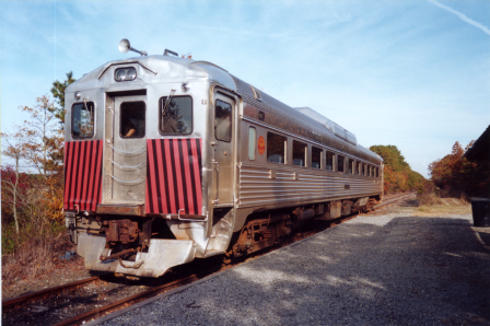
This trail is on what used to be the mainline of the Minneapolis & St. Louis Railway (M&StL) between Minneapolis and Peoria, Illinois. The M&StL primarily operated freight trains, but also had a small passenger service operation using Rail Diesel Cars (example of one shown below) until sometime in the 1950s. In 1960 the M&StL was acquired by the Chicago & North Western (CNW), and they continued to use this route for a few decades. In 1991, Eden Prairie planned to widen Valley View Road, which crossed under this rail line through what was known as Graffiti Bridge. Since this rail line was lightly used, the CNW simply abandoned it between Hopkins and Chaska.
Until 2007, the CNW, acquired by Union Pacific in 1995, continued using this rail line from the south to serve United Sugars in Chaska. However, because of flood damage to a trestle, a train derailed and several railcars toppled over. Since it would cost millions of dollars to repair the trestle when the railroad only made tens of thousands in profit from serving United Sugars, Union Pacific decided to abandon the rail line between Merriam Junction (southwest of Shakopee) and Chaska. In 2011 the rails and ties were removed, and a few years later a trail was built between Chaska and Carver. Note that coming from the east, the trail veers off the railroad right-of-way at Flying Cloud Drive, and you have to wind your way through Chaska before eventually meeting up with the railroad right-of-way again just west of Downtown Chaska. From there you descend into the river valley and end up at Carver.

A short section of this trail is currently closed in Eden Prairie, and has been for several years due to a small landslide. However, as part of a realigning of Highway 101, the trail will be repaired. This will be a welcoming change from the current detour that requires biking up and down steep hills, and a segment where you have to bike on the shoulder of a road with cars flying by you at 45-50 miles per hour. In addition the Minnesota River Bluffs LRT Regional Trail, as the name suggests, offers good views of the Minnesota River Valley and Downtown Shakopee.
Not much is left from when this was a railroad except a couple mileposts and telegraph poles. The biggest evidence of its past is the water tower in Carver, which was used by steam engines. In addition there is a CNW caboose on display, adding a nice touch to a local historical landmark.

In addition to the reopening of the trail in Eden Prairie, there are plans to extend this trail across the Minnesota River. As the name of the trail suggests, it’s a potential route for transit use. When Southwest Light Rail was being planned years ago, one of the potential alignments was utilizing this right-of-way all the way through Hopkins, Minnetonka, and Eden Prairie. Although it would’ve been cheap and easy to build, it would have required removing the popular trail that’s useful for both recreation and commuting. In addition, most of the area along this route is very low density, so ridership would be much lower. Although the Metropolitan Council stuck with the cheap and easy route (in theory) through Kenilworth instead of Uptown, they at least chose an alignment through the southwest suburbs that serves higher density commercial and residential areas instead of single-family homes and small business parks.
Although the Minnesota River Bluffs LRT Regional Trail between Hopkins and Eden Prairie will likely remain a trail, further west the right-of-way may someday be used for transit purposes. Just as with the Dakota Rail Trail, there would likely be a lot of opposition, and because much of the route between Eden Prairie and Chaska is on a berm, the trail would need to be significantly realigned. However, I do believe it’s worth studying its use for for transit; either regional rail to Mankato and New Ulm, or extending the light rail line from Eden Prairie to Chaska and Carver (and perhaps a branch across the river to Downtown Shakopee).
Big Rivers Regional Trail
If you want good views of the Minnesota River and its confluence with the Mississippi River, then the Big Rivers Regional Trail is the perfect place. From Lilydale to Mendota this trail slowly climbs out of the river valley on a railroad bed that used to be owned by the Milwaukee Road, later Soo Line. Between the junction with what is now Union Pacific tracks in Lilydale and just south of I-494 in Eagan, this rail line was abandoned in the late 1980s or early 1990s. From Eagan going south the rail line is still active and used by Progressive Rail to serve several shippers. Along the abandoned segment there are still several telegraph poles standing.
North Cedar Lake Trail (Hopkins)
As previously mentioned, this was the Great Northern’s original route to Hutchinson until 1899. After that it became a spur line to serve industries in Hopkins. I haven’t been able to find the year it was abandoned, but from photos I’ve found it was still in place in 1982 and gone in 1987. I haven’t been able to find railroad artifacts along the trail except a few wood ties.
At the western end in Hopkins the North Cedar Lake Trail connects with the previously mentioned Minnesota River Bluffs LRT Regional Trail. It also indirectly connects with the Lake Minnetonka LRT Regional Trail that goes to Excelsior and Victoria.
Repurposing this right-of-way, whether for transit or freight rail use, would be extremely difficult as several segments of the right-of-way have been significantly altered for development. It was considered as a possible option for rerouting freight trains back when the controversial freight reroute through St. Louis Park as part of the Southwest Light Rail project was still on the table, but it was quickly dropped from consideration. Preservation of the right-of-way could’ve been done better to perhaps allow transit or freight rail use in addition to a trail, but unfortunately development usually gets higher priority than potential future transportation uses.
Minneapolis Diagonal Trail
While it’s a short trail that starts and ends surrounded by industry, it does provide a way for bikers and walkers to temporarily have relief from auto traffic. The right-of-way was owned by Northern Pacific, later Burlington Northern, and connected with their route between St. Paul and Duluth via White Bear Lake. The rail line was abandoned between what is now BNSF tracks in Minneapolis and what is now Minnesota Commercial tracks in Roseville sometime in the 1980s or early 1990s.
The trail doesn’t appear to be very useful for recreation or commuting due to how short it is and the fact that it abruptly ends. On the eastern end the trail at least continues along roads through Roseville, but on the western end the trail stops at Broadway Avenue and dumps you onto a narrow and crumbling sidewalk. Hopefully there are plans to extend the trail further west and/or overhaul Broadway so it’s more pedestrian and biker friendly.
Gateway Trail
If you wanted to take the Soo Line from St. Paul to Duluth or Chicago, then your train would travel on what is now the Gateway Trail. Between St. Paul and what was known as Carnelian Junction (near Pine Point Regional Park) north of Stillwater, this was the Soo Line’s passenger mainline. Passenger service ended in the early 1960s, but it was still lightly used by freight trains until 1980 when it was officially abandoned. Railroad artifacts along this trail are very few and I’ve only been able to find two; a trestle over Westminster Street in St. Paul, and a wooden platform at Duluth Junction (where the Gateway Trail meets the Brown’s Creek Trail) that was used for heritage railway operations to Stillwater (more on that below).
Brown’s Creek Trail
Beginning from the west at Duluth Junction where it connects with the Gateway Trail, the trail slowly descends into the St. Croix River Valley and ends up at Downtown Stillwater. Originally it was a branch line of the Northern Pacific between White Bear Lake and Stillwater. After Northern Pacific became Burlington Northern in 1970, the rail line was used for freight service for ten more years, and then abandoned between White Bear Lake and Duluth Junction due to low freight traffic and the ability to access industries south of Stillwater on a better route owned by the Chicago & North Western. The abandoned segment has been mostly redeveloped, and from aerial photos it’s tough to see the exact routing.
The Minnesota Transportation Museum (MTM) took over the rail line between Duluth Junction and Stillwater, and operated daily excursions for several years. In addition, there was the Minnesota Zephyr dinner train, operated by a private owner. Sometime in the 1990s the MTM moved their operations to a different rail line further north, and the Minnesota Zephyr continued to operate until New Year’s Eve 2008. The dinner train was shut down due to decreasing patronage and expensive repairs needed for the locomotives, rolling stock, and tracks.
Lake Minnetonka LRT Regional Trail
Along with the Dakota Rail Trail, the Lake Minnetonka LRT Regional Trail is a good route for seeing and accessing Lake Minnetonka, most notably in Excelsior. For the Minneapolis & St. Louis Railway (M&StL), this was their route from the Twin Cities to South Dakota. In 1960 the M&StL was bought by the Chicago & North Western (CNW), and twenty years later the rail line was abandoned between Norwood Young America and Hopkins. There was only one shipper left on the abandoned segment, and it was cheaper for the CNW to utilize Milwaukee Road tracks from Hopkins to Norwood Young America with a new rail connection to their line to continue west.
The Minnesota Streetcar Museum uses a short segment of the railroad bed in Excelsior for their heritage streetcar operation. Although Twin City Lines (the operator of streetcars in the Twin Cities before operations shut down in 1954) did not utilize M&StL tracks, they did serve Excelsior on their own tracks until 1932.
As the name suggests, this is a possible transit corridor, but as of now there are no official proposals for repurposing the right-of-way for transit use. Early light rail feasibility studies from the 1980s may have shown this route as one of the considered options, but besides that there has been no serious consideration. Although it would be nice to have light rail serving Downtown Excelsior, most of the route is very low density and it would be difficult to justify replacing the trail with light rail or bus rapid transit. I do hope that someday there’s bus service along Highway 7 that operates all-day in both directions, which would make visiting Excelsior without a car much more possible.
Great Northern Trail
While probably overlooked, as it’s a short trail with no main destinations along the entire route, the Great Northern Trail is built on a railroad bed. It was part of the Great Northern Railway’s Milaca Branch, which branched off their mainline from Elk River to Milaca. It was built in 1886 after communities in Mille Lacs County desperately sought rail service. Although it was originally the Great Northern’s route between the Twin Cities and Duluth, it was downgraded to a branch line after a new and shorter route was built in 1899 between Coon Rapids and Hinckley (today this is BNSF’s Hinckley Subdivision).
Passenger service was offered between the Twin Cities and Milaca until 1952, though based on timetables from 1913, 1928, and 1947 there was only one roundtrip per day. A couple years after the merger that created Burlington Northern in 1970, the Milaca Branch was abandoned between Milaca and Princeton, and abandoned between Princeton and Elk River in 1976. More information on the Milaca Branch can be found here.
The rail-trail is only paved within Elk River, but you can continue on foot or bike a little further north on loose gravel and sand. Beyond that, the trail becomes vegetated and appears to only be usable for snowmobiles in the winter. The only notable railroad artifact I’ve been able to find along the trail is a sign from the Great Northern era.

And Many More
There are many more rail-trails around the Twin Cities; most of them are short (around a mile) and don’t have official names, but have a deep history like the trails I mentioned above. Based on the many rail-trails I’ve walked and biked in the Twin Cities region, railroad history is often overlooked, which should change. Without these rail lines being built, the Twin Cities could not prosper, and the trails we enjoy today would not exist.
There were several missed opportunities to repurpose rail lines as trails, notably the Twin City Lines streetcar route between South Minneapolis and Excelsior via Edina and Hopkins, and the Milwaukee Road’s Hastings & Dakota Division between Cologne and Hastings via Chaska, Prior Lake, and Farmington. Looking closely at aerial photos, you may be able to see remnants of these and other abandoned rail lines, and I’m sure there’s at least a few railroad artifacts on the ground but buried deep in vegetation.
America’s railroad industry is in much healthier shape than it was a few decades ago, and abandonments are now few and far between. That hasn’t stopped some communities from planning a rail-trail on a currently active rail line as if abandonment is inevitable. I believe those rail lines should be left alone until such time as the railroad petitions to abandon the route, and even then, studying the route for transit may be warranted. There are also potential opportunities for trails along active rail lines, which will be the subject of my next post.