
If you live in and around St. Paul and enjoy rolling and strolling, 2020 was a pretty exciting year (though 2021 felt like a bit of a hangover). Some of the most exciting additions to the cycling network were the extensions of the Grand Round, as covered by Bill Lindeke for Minnpost. These greatly expanded the choices for off-street path riding in St. Paul, connecting with several other options to make for some great routes around the city and beyond.
The extensions along Wheelock, Como and Johnson parkways are particularly exciting, especially the raised crossings for much of their lengths (a design feature that should be universally applied to all trail crossings) and intersection closures along Johnson. Andy Singer did a great job summarizing these and other new facilities. I’ve used and loved these new trails almost daily since they opened, but I’m also here to be a bit of a Debbie Downer. On a number of completed and upcoming projects, I submit that we took some steps forward only to (partially) walk back, or at least get less far than we could have. I try to avoid letting the perfect be the enemy of the good, but in these cases, I see significant daylight between perfect and aspects of what was done.
These issues matter. If we’re going to make any significant progress toward policy goals like reducing vehicle miles traveled (VMT) by 20 percent or 40 percent, we will need a lot of “push” and “pull” (or carrot and stick) — and we’ll need to make the “pull” of biking and walking as strong as possible given the lack of appetite for “pushing” people away from inefficient, single-occupancy vehicle use.
Although I am not an engineer or planner, these critiques are based on my experiences as someone who bikes pretty much every day to get almost everywhere I go, frequently on the routes I address below. I certainly don’t claim to speak for others, but I know what feels comfortable and safe to me as someone who, at various times, straddles either side of the “strong and fearless” and “enthused and confident” border, so I’d venture that most people have a lower comfort level than I do.
Dead Ends and Fast Turns
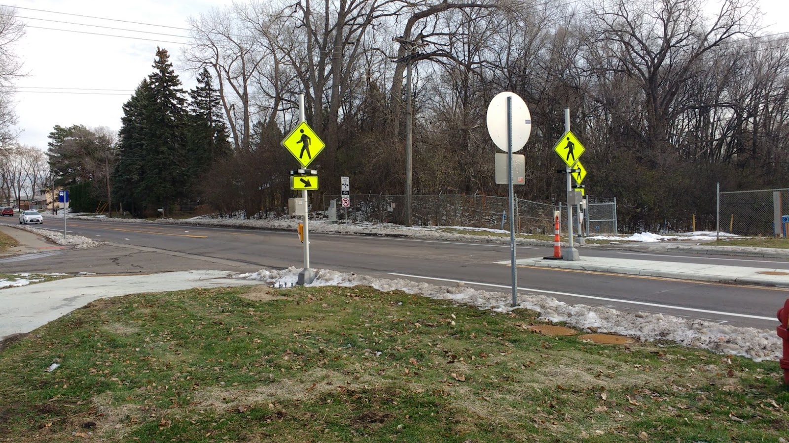
The Wheelock segment of the Grand Round starts with a dangerous, unnecessary slip lane near Como Lake and still ends unceremoniously about five blocks short of Phalen Regional Park where the Grand Round continues (Figure 1), though on a one-way path that forces you to go the long way around the lake if following the Grand Round clockwise. Most of the remaining gap between Edgerton and Arcade has a wide median that could accommodate a slightly meandering path, likely without removing any or many trees. It also would have helped if the new Wheelock sections could have eliminated more crossings or extraneous driveways as was done along Johnson.
The area around Rice Street from Marion to the bridge over Trout Creek requires particularly close attention as drivers frequently turn at fast speeds without looking for trail users at these cross streets. This stretch needs some work to slow the cars or restrict turns — something like the lane dividers along 6th Street between Maria and Hope (Figure 2).
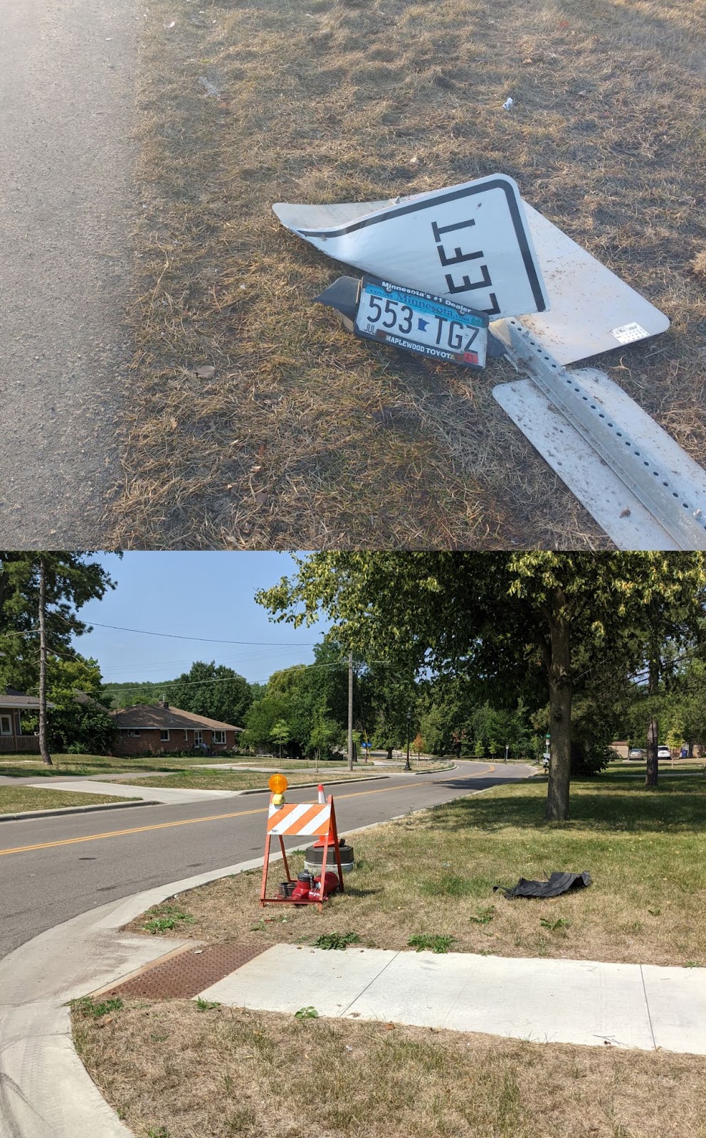
This problem is evidenced by the number of damaged street components in the area. I’ve come across multiple flattened street signs on each block between the bottom of the Wheelock curve and Rice Street over the past year (Figure 3). In fact, while I was taking the photo below of the destroyed streetlight and fire hydrant, a driver nearly jumped the curb on the same block, something I’ve witnessed at least three times in the stretch of Wheelock between Dale and Rice. The signs on the lane divider at the top of the Wheelock hill have been knocked over at least three times themselves. Despite slightly narrowed lanes as part of the remodel, the street design still clearly encourages speeding and unsafe behavior.
Begging for Attention
Another persistent (and somewhat universal) problem is that signals at several trail crossings of arterial streets still require pushing a beg button (which are often antiquated and/or inaccessible) to get a crossing signal, even when car traffic in your direction has already triggered a light change. This is the case where Wheelock crosses Rice and Dale and the intersections of Phalen with Payne and Johnson.
This last intersection is particularly egregious given that it is the intersection of two major trails — the Vento and Johnson/Grand Round — and is the major route to access Phalen Park from the south. Each light at the very least should feature automatic crossing signals when any kind of traffic is present, ideally with a leading pedestrian interval by default. Why spend millions on these great facilities, then fail to give them this modest priority? St. Paul’s street design manual says that in areas of high pedestrian (and cyclist?) use, beg buttons should be avoided and a crossing signal should be given automatically at each light cycle. Even if the city lacks updated usage data of the Wheelock or Johnson trails, crossings of major trails should be assumed to have high usage by people strolling and rolling citywide and given crossing signals by default.
When contacted about the issue, the Public Works department implied that a limited pot of safety improvements will be tolerated in the name of preserving auto-centric “efficiency,” and these don’t make the cut. Though refreshingly honest about pervasive “cars über alles” views, and despite city and county complete streets/all abilities resolutions, this subservience to the least efficient transportation option over the safety and convenience of other modes needs to end if we want any chance of achieving VMT reduction goals.
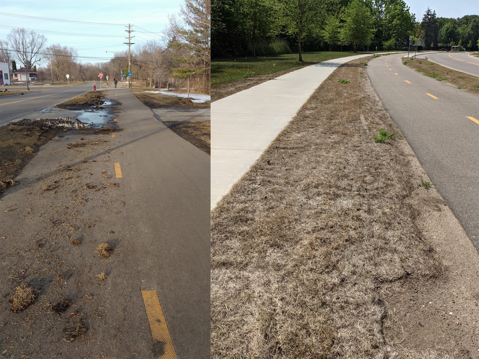
Lastly, it would have been nice to see a more environmentally thoughtful option than sod added for much of the public boulevard areas, such as a pollinator blend that would require less mowing and watering while promoting biodiversity. Given that winter plowing tore up much of the sod anyway, then last summer’s drought killed off most of what remained, maybe this could be revisited? For now, hardy weeds and invasives are replacing the dead, torn-up sod (Figure 4).
Protected Bike Lanes and Safe Intersections
The next issue, at the intersection of Trout Brook Trail and Larpenteur Avenue, arose as part of a larger 4-to-3 conversion of this stretch of Larpenteur, with the addition of bike lanes. This is a great project, overall, though one that probably has a negligible benefit to anyone cycling, given that most people won’t feel comfortable biking in a gutter bike lane on a stroad like Larpenteur, even if it has three lanes instead of four. I’m usually not afraid to ride in and around traffic, yet I’ll probably never ride here for more than a few blocks because it’s highly unpleasant — and one of the biggest benefits of biking is how pleasant it is even when remotely good (i.e. not completely auto-centric) infrastructure exists.
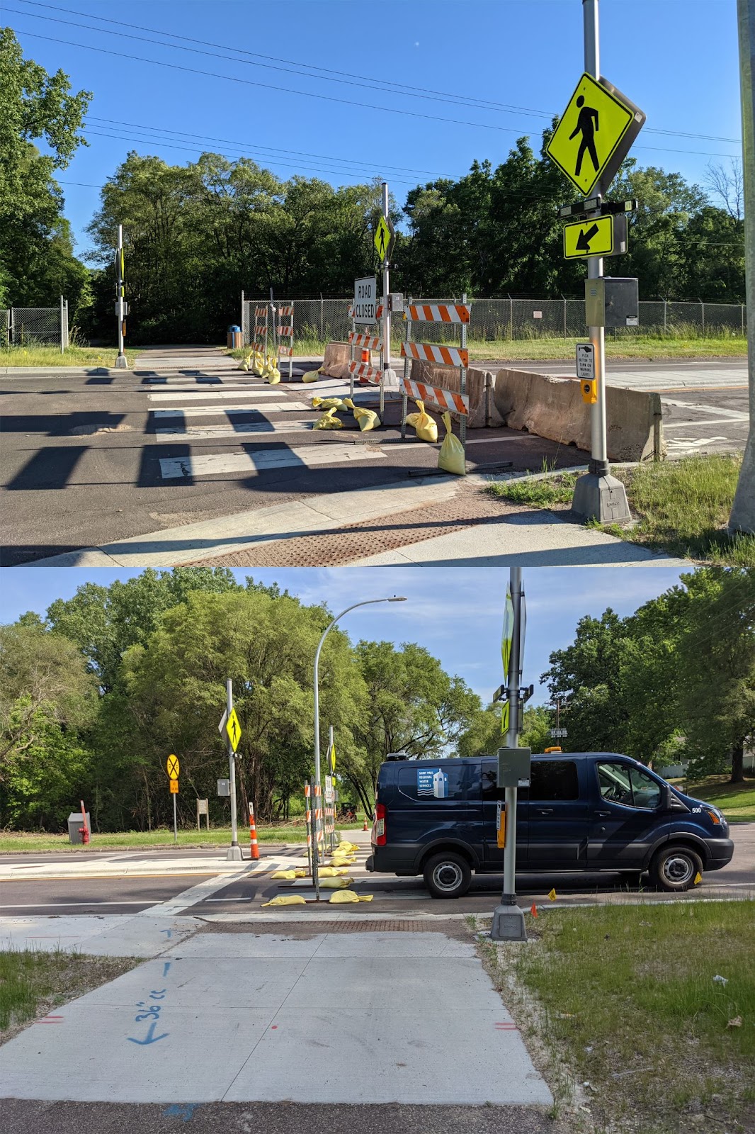
This trail crossing used to have a stoplight with a highly responsive beg button. Although I dislike beg buttons, in this case it provided a quick and safe way to cross the four traffic lanes, because most drivers stop for red lights. To my surprise, one day I came along this route only to find the stoplight gone and the bike crossing completely blocked by road and utility work, with no warning in either direction or indication of a detour. As part of the 4-to-3 conversion, a concrete island was being installed with push-button rectangular rapid flashing beacons (RRFB, Figure 5).
Generally this would be a welcome addition to a previously unsignalized trail crossing, especially if it had infrared sensors or other automatic detection of people strolling and rolling like the Griggs Street crossings of St. Anthony and Concordia in St. Paul. But as any regular walker or cyclist likely knows, plenty of drivers ignore RRFBs, such as the similar set nearby where the Trout Brook path crosses Rice Street.
Additionally, these particular RRFBs sat inactivated for months after installation and are difficult to access in the winter due to snow accumulation from poor plowing. Also of concern, the concrete island extends only to the west of the crossing, so you’re unprotected from westbound Larpenteur traffic. For months this crossing was essentially worse than it was before, with no crossing signalization of this busy road, and this didn’t change significantly once the RRFBs were finally activated.
Already I have noticed drivers ignore the beacons, and I’ve been honked at multiple times for legally crossing the road. I’m sure traffic volumes didn’t warrant a stoplight there so it was removed as a byproduct of the project. But despite the overall benefits of the road diet and half-median, the new set-up represents a downgrade as far as safety and ease of crossing. For awhile this summer, Larpenteur was closed at this location due to a sinkhole in the roadbed near the railroad crossing, meaning you could safely and easily cross again, unless construction crews blocked the crossing with carelessly placed signs or vehicles (Figure 6).
Building for the Past
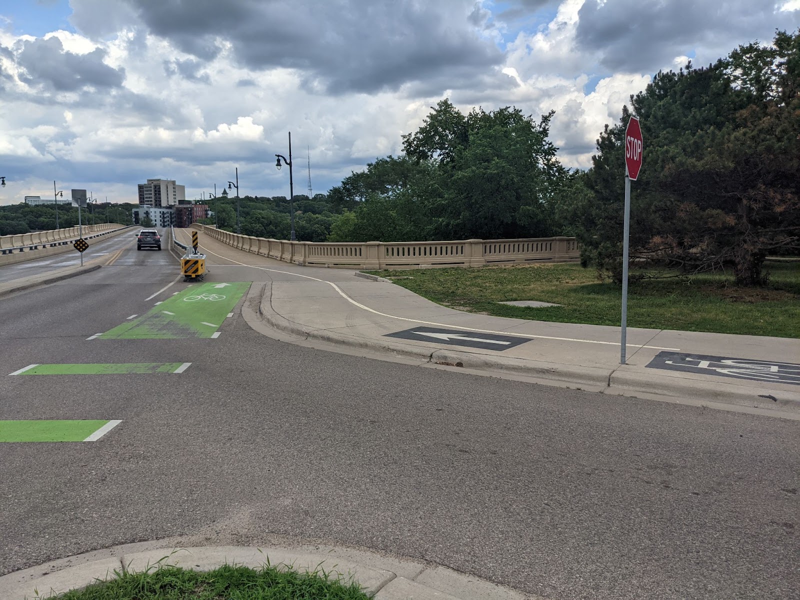
Another case of unfortunate outcomes is the recently rebuilt Summit Avenue bridge. I understand that it wouldn’t make sense to install a protected bike lane for just the section over the bridge, the current design complicates or all but eliminates the possibility of adding such features if or when Summit is reconstructed, because the roadbed is only as wide as the bike and auto lanes. I do hope that the large concrete mesa in the middle is intended to enable a future shared-use path down the middle of this section of Summit. With this current set-up, drivers tend to drift into the buffered areas at high speeds, emphasizing the importance of some kind of physical protection (Figure 7).

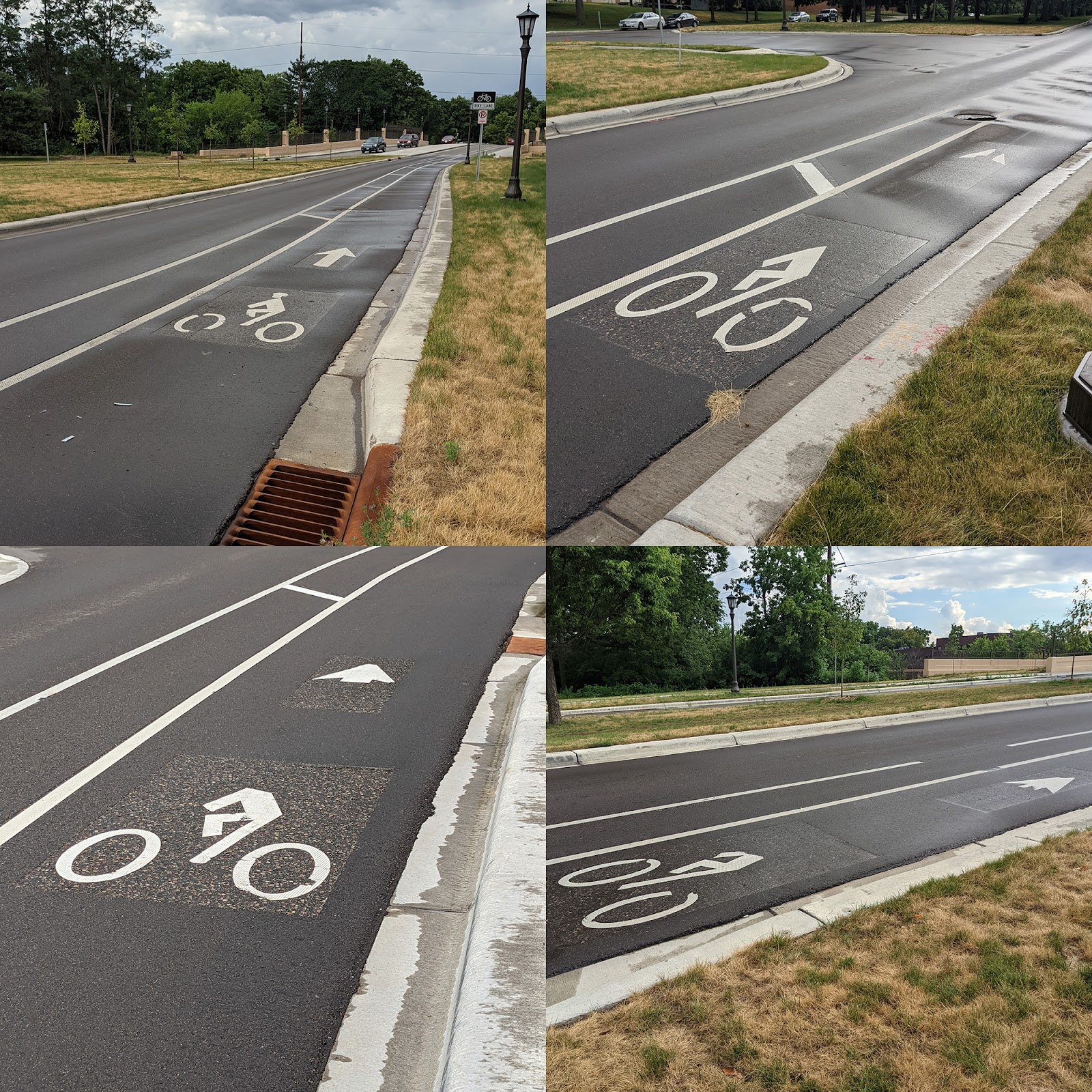
A better design for both safety and future-proofing the new Summit bridge for protected infrastructure would have been like those on the Franklin Avenue bridge in Minneapolis or the Raymond Avenue-University of Minnesota Transitway underpass, which combine bike lanes with space for people walking, instead of car lanes (Figure 8). This doesn’t need to take any additional space; in fact it can be less. On the Franklin bridge, the combined biking/walking surface is about 17 feet wide, while the same space, including the buffer, is about 20 feet wide on the Summit Avenue bridge. Including the protective wall and small shoulder, the two bike/walking surfaces are nearly the same width.
The Franklin Avenue design should be standard throughout the Twin Cities. It provides year-round safety with robust physical separation from car traffic while using a concrete wall to prevent snow removal from clogging the side paths — a well-known issue along Summit already evident this winter after only modest snowfalls. The more confined car space on the Franklin bridge also discourages speeding by reducing apparent roadway width. The Smith Avenue/High Bridge in St. Paul could also have benefited from this design. Instead, narrow bike lanes are squeezed in between a concrete divider and 40 mph speeding traffic. No wonder most people riding stick to the sidewalk space on the bridge.
Unfortunately, the uninspiring Summit design seems matched by the quality of construction. Within weeks, significant chunks of the lane markings had been torn off, producing three out of four headless cyclists (Figure 9). The junctions between the roadway and bridge deck are also severe, so any skinny-tire bike gets a sharp jolt (and potential pinch flat) crossing the bridge. It appears that the contractors got called back to address this, grinding down the surface on the bridge (though mostly for the car lane), but the lane markings were finally repaired almost a year later.
Roads Through Green Space?
This phenomenon of obsolete, auto-centric thinking and sub-par design applies to the recently reconstructed West 7th/Lexington/Montreal intersection. As with the Larpenteur reconstruction, this change in the traffic pattern started as a huge improvement, simplifying what had been a dangerous intersection for all road users. While not fully an example of the Dutch knip or filtered permeability concept because Lexington was reconnected to West 7th a block away, it did make travel by car between Lexington and Shepard a little less direct, while enabling active users to access the crossing.
However, Phase II of this project promises to erase any gains achieved in Phase I by attempting to make a quick and convenient connection for car drivers between Lexington and Shepard via an extension of Elway Street. What started as a project to enhance safety now turns into a plan to turn the southern stretch of Lexington into a glorified freeway on-ramp for Shepard Road and 35E south.

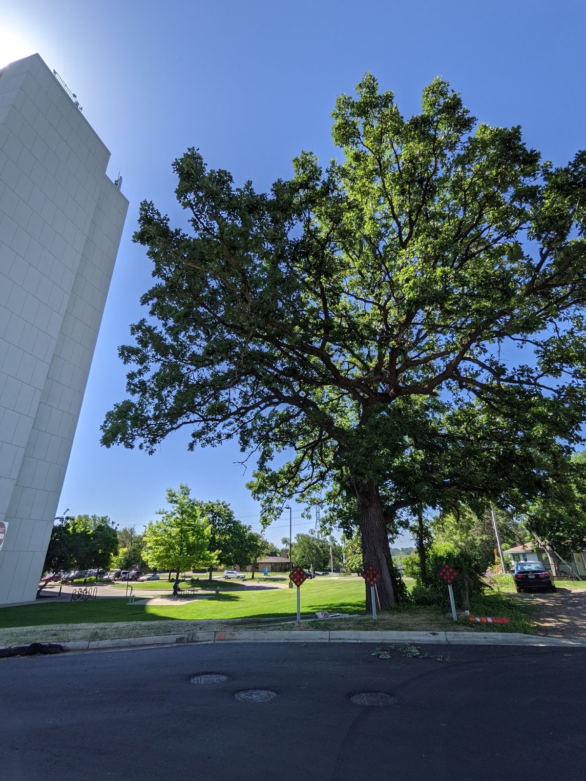
From the perspective of the three Es (equity, environment, economics), Phase II is almost universally a failure. Current plans appear to eliminate a beautiful old oak tree and green space from public housing in order to make it faster and easier for those from the wealthiest, whitest neighborhoods in St. Paul to drive past said housing, increasing exposure of residents to noise and exhaust pollution (Figure 11). All of this is “achieved” while spending money we don’t have ($3.3 million, according to a recent article) for increased road capacity we don’t need while working against stated city and county policy goals by building new roads.
At a virtual meeting to discuss and present these plans, numerous participants expressed concerns about the plan, citing issues such as induced demand and increased noise and emissions pollution directly impacting both the Montreal Hi-Rise and new senior living complexes, but county staff largely left these concerns unaddressed. They justified the project with the need to get traffic off West 7th, but the current set-up has a nearly half-block-long left turn lane along West 7th onto Montreal, which is more than adequate.
The potential of adding off-street paths between Montreal and Shepard was touted (and the released plans do include them, as well as the city’s first roundabout), which would improve the embarrassingly bad current sidewalk. But the weak link in the active transportation chain to get more people walking and biking to Shepard and Crosby Farm via this connection isn’t Elway: It’s the route via the basic, barely-good-enough gutter lanes or door zone bike lanes on Lexington and Montreal and the unpleasant crossing of West 7th.
Again, Phase I made some improvements here, though not nearly enough. (Why don’t the Montreal bike lanes continue the two additional blocks to Elway?) But increased priority and space for private, inefficient car travel in Phase II will negate most of the gains, while costing taxpayers $3.3 million plus ongoing maintenance.
Overall, the meeting could have been a case study in why most public engagement is pointless. This is exactly the kind of project we need to avoid if we want to improve our cities for walking and biking, and make them more financially and environmentally resilient. A better design could have simply added a shared-use path to connect Elway and Lexington, which would have made it safer and more convenient to access Shepard Road and Crosby Farm by active modes, while avoiding the need to take out so much green space and induce traffic and pollution.
And if Ramsey County really wants to improve access, they should take the remaining money from skipping most of this bloated plan and build a shared-use path along Montreal from West 7th to at least Hamline, though going all the way to Davern Street to serve the Highland Park school complex and provide a safe connection from the Highland Park neighborhood to West 7th would be even better. This could be done on the cheap for most of the stretch along the Highland Park golf course, which has wide, mostly unused parking lanes that could easily be repurposed. Most of the time I pass this stretch, I see more free-range golf balls “parked” along the curb than cars.
A Final Plea
I am thrilled overall by these addition to the growing network of biking and walking spaces in St. Paul. While many of my objections might seem nitpicky, I believe they point to a mentality at the city, county and state level that prioritizes auto traffic above all other modes, despite policies that theoretically direct the opposite priority to be used, with people walking and biking first and car traffic last. Spaces for people are still primarily just shoehorned into space where auto drivers are the top priority.
If we truly want to create an environment where anyone can feel safe to bike or walk, which will be an essential aspect of any VMT reduction goals, that can’t just happen midblock or on a stretch of trail without crossings. It has to extend throughout the entire facility, especially where conflicts are most likely to occur. Places like Wheelock partially get this, with its excellent use of raised crossings at some intersections, but they fail with a lack of priority at lights, wide rounded corners that encourage speeding, and too many crossings overall.
Additionally, most of the recent additions to the off-street network have limited potential for use beyond recreational, such as commuting or running errands (the main generators of trips), since they tend to stick to the city outskirts instead of safely connecting significant traffic generators, as noted by Samuel Burgess. I love to see these signifiers of progress and personally enjoy them almost daily, but I believe we have the capacity and responsibility to make them even more attractive to a wider range of users!
Feature photo courtesy of Mark Stosberg on Unsplash