
The most expensive Bus Rapid Transit (BRT) line has opened between downtown St. Paul and Woodbury. Creating previous BRTs was mostly a matter of building stations and painting buses in a different color scheme. The Orange Line from Minneapolis to Burnsville was more ambitious, with a long-overdue station on I-35W at Lake Street and a route-shortening tunnel under I-494. However, the Gold Line required five miles of exclusive busway, plus another half mile of on-street bus lanes.
Squeezed into the right of way on the north side of I-94, the new busway includes five bridges over streets, plus tunnels under White Bear Avenue and Ruth Street. Three new park-and-ride lots were built.
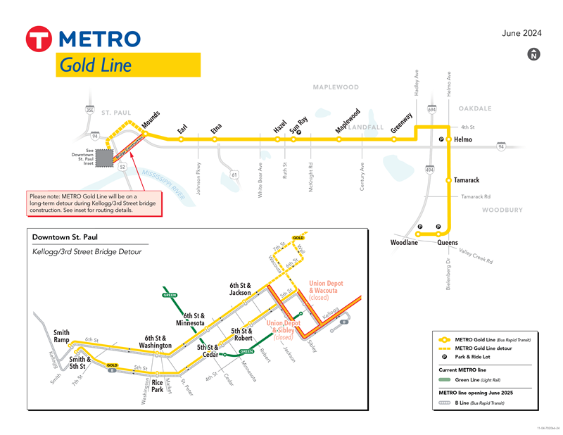
The Gold Line travels through downtown St. Paul in mixed traffic on the Fifth Street and Sixth Street pair, which feature full-time bus lanes for most of their length. There are eight new downtown stations, not including a pair in Lowertown that won’t be used until the Kellogg Boulevard bridge is rebuilt. Because so many buses use the Fifth-Sixth pair, the four busiest stops are separated from the local routes to reduce congestion. The new stops are being shared with Route 21 (to become the B Line BRT in June 2025), and future BRT Routes 54 and 94.
Leaving downtown requires a detour via East Seventh Street to bypass the rebuilding of the East Third Street bridge. The busway starts at the intersection of Third Street and Mounds Boulevard. From there:
- It follows the north side of I-94 and ends just east of Century Avenue, except for a brief mixed-traffic section west of White Bear Avenue.
- After crossing Century Avenue, it enters Hudson Boulevard for a short stretch in mixed traffic. An on-street bus lane starts at the Greenway Avenue station and continues as the route jogs north on Hadley Avenue.
- Turning right on Fourth Street to cross I-694, the full busway reappears in the center of the street. It turns south next to Helmo Avenue, stopping at Helmo Station and a new park-and-ride lot just north of I-94.
- Helmo becomes Bielenberg Drive after crossing I-94 on another new bridge. The median busway ends at Guider Drive where the BRT turns west.
- It stops at the existing Woodbury 10 Theatre park-and-ride behind the Woodbury Village shopping center.
- The line ends at the large new Woodlane park-and-ride ramp hard up against I-494.
Stations on the busway are spaced about every half mile to a mile apart. The speed limit on most of the busway is 45 mph. Travel time from Woodbury to the middle of downtown St. Paul is 29 minutes. When the Third Street bridge reopens into downtown, that should shorten the running time by a couple of minutes. That compares with 21 minutes for the rush-hour Route 351 express, which has been discontinued. Rush hour express 355 will continue to run non-stop to downtown Minneapolis via I-94.
The Gold Line is much faster than the old 50-minute off-peak alternative, Route 323 to Sunray and a transfer to Route 63. The frequency of every 10 minutes on weekdays and every 15 minutes on weekends is a major service improvement.
Will It Be Successful?
The Gold Line will have to overcome some long odds. All the previous BRTs built on a foundation of established transit service. The Gold Line is starting almost from scratch. It’s doing so on the St. Paul side of the metro area, which has always been a weaker transit market than the Minneapolis side, going back to streetcar days. Downtown St. Paul is about one-quarter of the market downtown Minneapolis is.
Between St. Paul and Oakdale, the Gold Line’s location along the north side of I-94 prevents anyone from accessing it on foot from the south side of the freeway, except at the Earl Street Station. Once in Oakdale, the line passes through a lot of undeveloped land, raising the question of whether — and when — development will occur. The Woodbury portion is intermittently developed, so the timing of infill is also an issue. Where Woodbury is developed, the pattern is classic suburban sprawl, spread out with long walking distances.
Given those realities, did the planners do everything they could to make the line a success? I see both positives and negatives.
On the positive side, the line is fast, frequent and will have high on-time reliability. Like light rail, the presence of a permanent busway and attractive stations is a marketing tool, and assures the public that this is permanent. There is probably more than enough park-and-ride capacity. Although it’s an untested new concept, the Metro Micro 2-square-mile dial-a-ride area on the outer end of the line has to be a plus for first-mile/last mile distribution in a sprawl landscape.
Station by Station
Mounds Boulevard and Third Street: Route 63 already offered good service to this corner, so the Gold Line’s primary impact is opening up access to the suburban employment market.
Earl Street: This station had only Route 70 hourly weekday service and no weekends, so the Gold Line dramatically improves frequency, coverage and suburban access.
Etna Street and Hazel Street: At both of these stations, the Gold Line brings first-time transit service to a large concentration of apartments near I-94 that previously had a long, inconvenient walk to Route 63 on Third Street. Suburban access is also a plus.
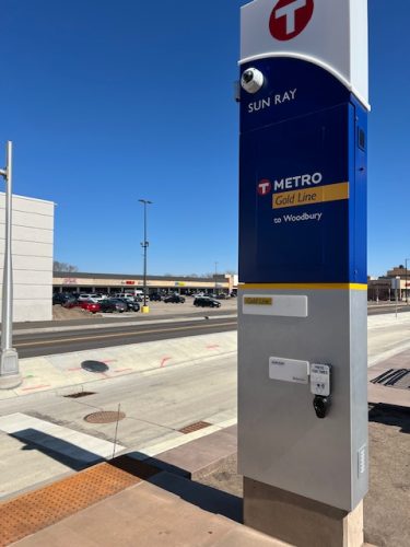
Sunray: This is likely to be the busiest intermediate stop because it conveniently serves Sunray Shopping Center and it’s near (but not convenient to) the Sunray Transit Center. Created over 20 years ago, the transit center tied together most of the East St. Paul, Maplewood, Oakdale and Woodbury bus routes with timed transfers. Today, six routes converge there.
Unfortunately, it’s a 700-foot hike, more than two football fields, to the Gold Line. All six routes circle the block to turn around and pass directly by the Gold Line Station in one direction. Because moving the transit center closer doesn’t seem to be an option, Metro Transit should add bus stops at the intersection of Hudson Road and Pedersen to make the connection more convenient.
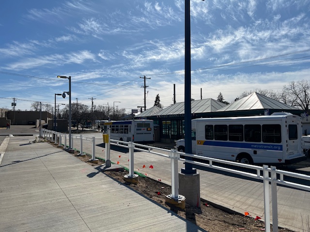
The Gold Line built a new park-and-ride lot just east of the Sunray Transit Center. It’s even farther from the station than the transit center. It would have been smarter and cheaper to rent space in the mostly vacant portion of the shopping center parking lot, only 150 feet from the station.
Maplewood: This stop serves only 3M, which has had only minimal bus service by Route 219 Sunray-White Bear-Maplewood Mall. Their campus is enormous, a mile east-to-west and a half mile north-to-south. The planners chose the best available option, a station next to the headquarters building. It’s a very long walk to anywhere else on the campus. That said, I was pleased to see an employee board with his bike, certainly a new rider.
Greenway Avenue: One must ask why this station was not located a quarter mile west, at the Dellwood Lane entrance to the large Landfall trailer park. I counted 256 trailer homes in Landfall, compared with 107 single-family houses in the comparably sized neighborhood adjacent to the Greenway Station. It would be OK if there was direct pedestrian access from the southeast corner of the trailer park to the station, but there isn’t, so the trailer park residents face at least a half-mile walk.
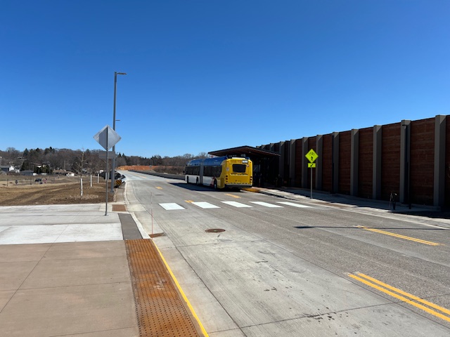
Helmo: This station serves a new park-and-ride, likely to be the busiest on the line. Across the street is a new high-rise apartment building, with more development likely to come. There is a lot of undeveloped land nearby.
Tamarack: Development along Bielenberg Drive is scattered, but future infill should help this station. The fully developed southeast and southwest quadrants of the intersection lack pedestrian access to the station.
As is often the case in sprawl landscapes, pedways between the arterial street and the private developments are missing.
Queens and Woodlane: Queens station serves the Woodbury Theatre park-and-ride lot and is as close as the line comes to the large Woodbury Village retail concentration, about a two-block walk uphill on Queens Drive. The line continues on Guider Drive to the large new Woodlane park-and-ride ramp, hard up against I-494 and not near anything but a few apartments.
I think this was a major mistake. Commuters must travel out of direction to use the Woodlane lot. The other park-and-rides are better situated, and I predict Woodlane will be underutilized. Meanwhile, access to Woodbury Village retail for workers and shoppers is inconvenient at best. Better to reroute the buses around the front of the shopping center, add a station there, then go to the Woodlane terminus.
Passengers can download the Metro micro dial-a-ride app to summon a ride to or from the Gold Line. When not roaming, the dial-a-ride buses can wait at Woodlane for walkup passengers.
While the Third Street/Kellogg Boulevard bridge is being rebuilt, I don’t understand why Metro Transit detoured the eastbound Gold Line, Route 63 and Route 70 buses via East Seventh Street. They could save time by using the Sixth Street entrance to I-94, then immediately exiting to Sixth Street and Mounds Boulevard. The entrance has an HOV ramp meter bypass, and this option avoids six traffic signals and a fair amount of congestion.
Future Incremental Help
The Gold Line runs every 10 minutes on weekdays and every 15 minutes on weekends. This is an introductory level of service meant to jumpstart ridership. I doubt that this much frequency can be sustained over time, because this is not a high-potential ridership corridor. Some future improvements will help, although how much is uncertain. Infill development will be important in Oakdale and Woodbury. Some apartment complexes are already happening. It’s unclear if there are any development opportunities in St. Paul.
In 2027 the Gold Line is scheduled to be combined end-to-end with the all-day Route 94 express to downtown Minneapolis, creating a fast, one-seat ride that should attract some additional riders. This will have the byproduct of reducing the cost of duplicate bus miles within downtown St. Paul. It will also upgrade Route 94, already one of Metro Transit’s fastest routes, to full BRT with better stations and off-board fare collection.
The Network Now plan to overhaul the route system calls for new feeders to the Gold Line from North St. Paul, Maplewood, Oakdale, Woodbury and Cottage Grove. Proposed Route 354 will connect the Woodbury end of the Gold Line to Newport, South St. Paul, West St. Paul, Mendota Heights and the airport via I-494 and Highway 62.
While I wish the best for the Gold Line, I fear it won’t attract much ridership, and that will make it hard to justify another such an investment in the future.
New Eden Prairie-Airport Bus
SouthWest Transit has finally filled an important hole in the transit system with the new Route 686. It opens up all sorts of trip options that were previously unavailable.
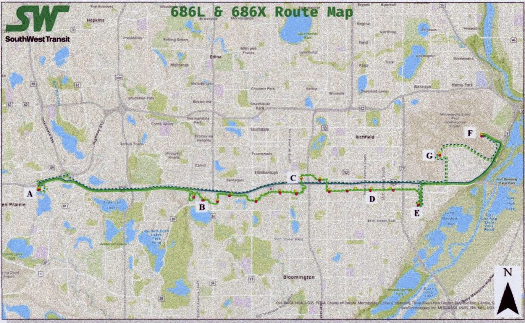
Actually it’s two routes, both of which connect the Eden Prairie Station with the airport. Both start their trips on I-494. Route 868L (L for Local) exits at Bush Lake Road and crosses Bloomington on American Boulevard, which parallels 494 two blocks to the south. Stops are made every half mile all the way to the Mall of America. From there, it travels to Airport Terminal 2, then Terminal 1. Along the way, it connects with a whole series of Metro Transit routes, including 540, 542, 4, Orange Line, 534, 538 and 18, D Line and 515. At MOA, it connects with the Blue Line, Red Line, Route 54 to St. Paul and Minnesota Valley Transit 442 and 444. Service is Monday through Friday, 5 a.m. to 7 p.m. Fares are the regional standard of $2 for adults and $1 for youth 6 to 12 and seniors 65-plus.
Route 686X is express and non-stop from Eden Prairie Station to the airport via I-494. It stops first at Terminal 1, then Terminal 2, then MOA (westbound only) and immediately returns to Eden Prairie. Service runs 5 a.m. to 11 p.m., every day. The fare is $3.25 peak periods, $2.50 off peak and $1 off peak for youth and seniors. Since this is designed for airport travelers, parking for $5 per day is offered at Eden Prairie Station.
A Misguided Stop-Spacing Policy
I seldom criticize Metro Transit, where I used to work, but their new bus stop spacing policy is wrongheaded. One route at a time, they have been eliminating almost half of the bus stops, from the former standard of eight stops per mile (every long city block, every second short city block) to four stops, essentially quarter-mile spacing.
This started some years ago in an effort to speed up Route 2 (Franklin Crosstown), which was notoriously slow, because it’s a heavily patronized center-city route. A passenger seems to get on or off at every stop, so wider stop spacing is a reasonable tradeoff to achieve higher speed.
That makes sense in the neighborhoods within a couple of miles of downtown Minneapolis, where buses stop frequently. It makes no sense anywhere else, because ridership is much lighter, and the bus actually stops every quarter- to half-mile, even where the stop spacing is eight to the mile. Metro Transit is deleting half the stops in those neighborhoods as well, even though it doesn’t speed up the bus at all. All it does is make bus access less convenient, and that has to reduce ridership.
A Sensible Riverview Corridor Proposal
Now that light rail has proven technically infeasible in the Riverview Corridor from downtown St. Paul to the airport and Mall of America, a sensible plan has emerged. It reverts to something close to Metro Transit’s original proposal to upgrade the existing successful Route 54 to BRT by doing the following:
- Rerouting it near downtown via Smith Avenue, improving access to United Hospital and Children’s Hospital.
- Diverting it onto the former Canadian Pacific railroad right of way between Lexington Avenue and St. Paul Avenue. This frees it from traffic congestion on West Seventh Street, while bringing it closer to the neighborhood it serves.
- Between the airport and Mall of America, a bus-only off ramp is proposed to bypass the crowded I-494 and 34th Avenue exit.
The Smith Avenue and CP rail diversions may add a couple of minutes’ travel time, but they will bring the bus stops closer to more residents and make schedule adherence more consistent.
If this were a transit-only project, it could probably be up and running in a couple of years. However, this is envisioned as a “something for everyone” package. That includes a completely rebuilt streetscape on West Seventh and a bike trail on the CP right of way. Two years are anticipated to achieve public consensus, followed by two to three years of design and three years of construction, hence no opening until 2031 or 2032. Total cost is projected to be $450 million to $550 million.