
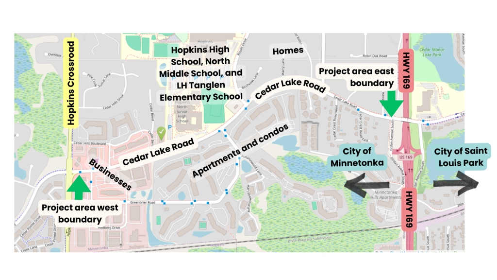
Cedar Lake Road, between Hopkins Crossroad and Highway 169, in the city of Minnetonka is a critical connection for my daily life. It connects me with two sources of employment, my primary Aldi, and my favorite burrito restaurant, Britos Burrito. It also connects my neighbors with some of the densest housing options in the city of Minnetonka, three Hopkins public schools and a variety of small businesses.
I ride my bicycle on Cedar Lake Road almost every day, mostly for work, but also for play, year-round. Unfortunately for me and my neighbors, whether intentionally or not, Cedar Lake Road is deadly by design. Here’s how:
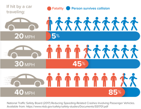
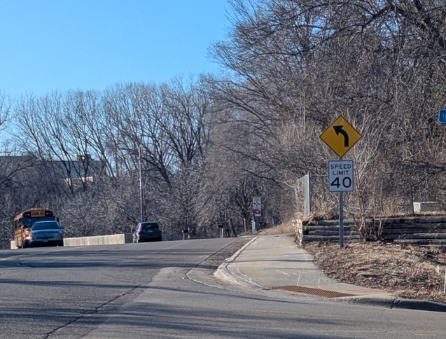
- Road signs indicate a speed limit of 40 mph, fast enough to kill 85% of pedestrians on impact according to data which predates the increases in vehicle size and weight that have occurred over the last thirty years.
- The wide, unobstructed lanes encourage reckless driver behavior by lowering the risks drivers perceive when they are speeding and driving while distracted.
- Speed limits are rarely enforced; instead, it is culturally accepted that drivers will drive ten mph or more above the legal limit, often with a phone or coffee mug in hand.
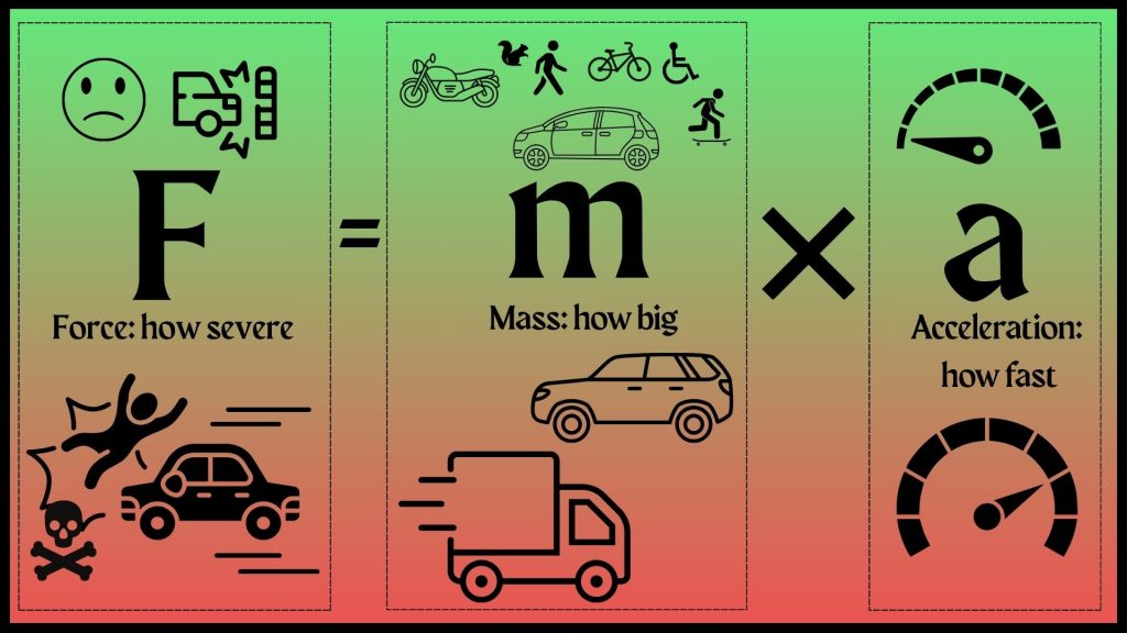
Larger mass and higher speeds lead to more severe crashes. Newton’s second law — force equals mass times acceleration — helps explain why high speeds combined with heavy vehicles is a recipe for severe traffic violence.
Staff members at Hopkins High School, adjacent to Cedar Lake Road, were pleasantly surprised to learn that, according to data from the Minnesota Department of Public Safety, only one pedestrian had been killed — and at least one other injured — in crashes in this area since 2016. I don’t believe any such violence should be permitted within eyeshot of a school, but this, sadly, is what Cedar Lake Road is currently designed for.
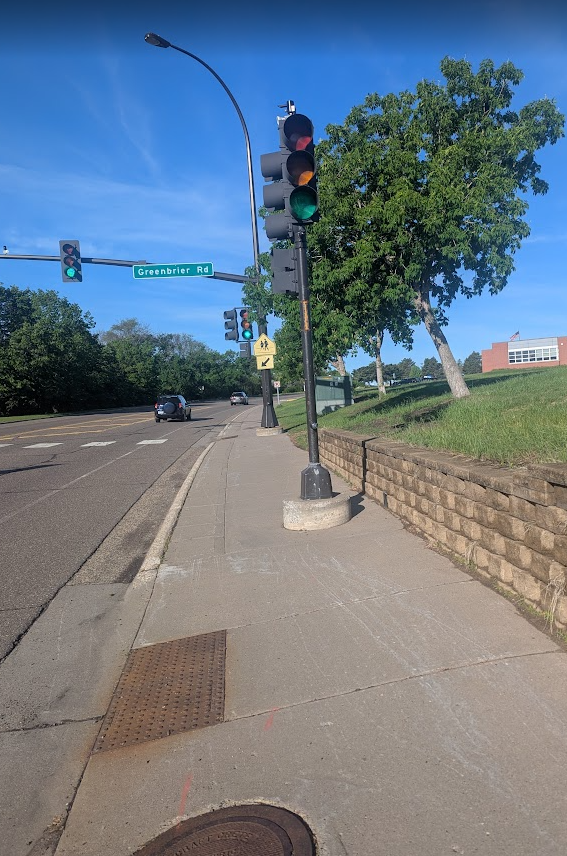
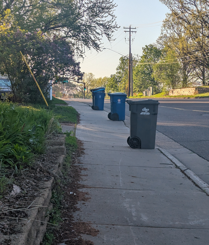
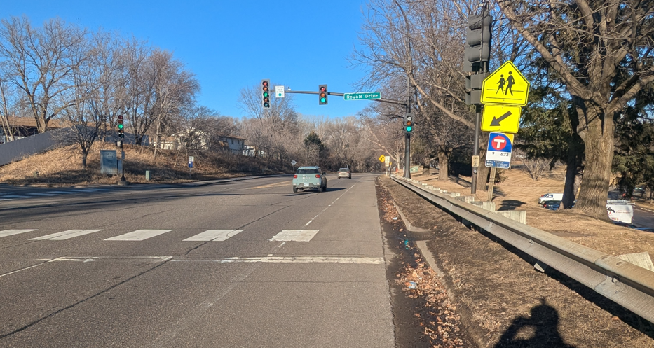
Given the choice, people choose not to walk or bike on or near Cedar Lake Road because the space is not designed to accommodate people outside of cars. The only space provided for pedestrians in the 50-plus-foot right of way is a five-foot wide, curb-separated sidewalk on the north side of the road that is poorly maintained and often obstructed by garbage cans, snow, debris and fixed objects, like signs and light posts.
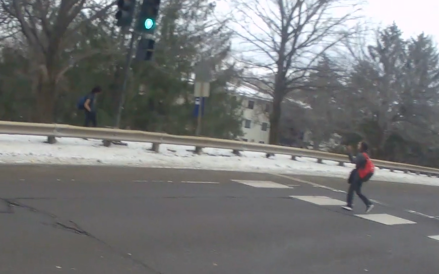
Transit users may wait on this sidewalk for their buses, if they’re lucky enough to be heading west but have no safe space for an eastbound bus. Most eastbound transit riders stand in the grass — or snow, as the season dictates — or on the opposite side of highway style barricades, but people who are not physically able to reach those spaces wait in the road, with nothing protecting them from speedy vehicular traffic.
People riding bicycles must choose between cosplaying as a pedestrian on the sidewalk or as a car on the road, neither of which is safe or ideal. Cyclists often choose to ride on the sidewalk — where drivers are even less likely to see them as they cross the thirteen driveways and intersections scattered along the mile-long stretch of road — because they understandably feel unsafe riding close to cars moving fast enough to kill them.
Riding on the sidewalk introduces additional challenges for cyclists who are not comfortable riding on the road. On Mother’s Day, May 11, 2025, I stopped my bike ride on Theodore Wirth Parkway to help a cyclist who crashed because her front wheel narrowly missed the curb cut to re-enter the sidewalk while crossing the entrance to the Quaking Bog Parking lot. The rider escaped with only a fractured wrist and a dislocated finger, but the incident highlights how a seemingly minor feature, a curb cut in this case, can become a major barrier to mobility.
What Is Minnetonka Doing About This?
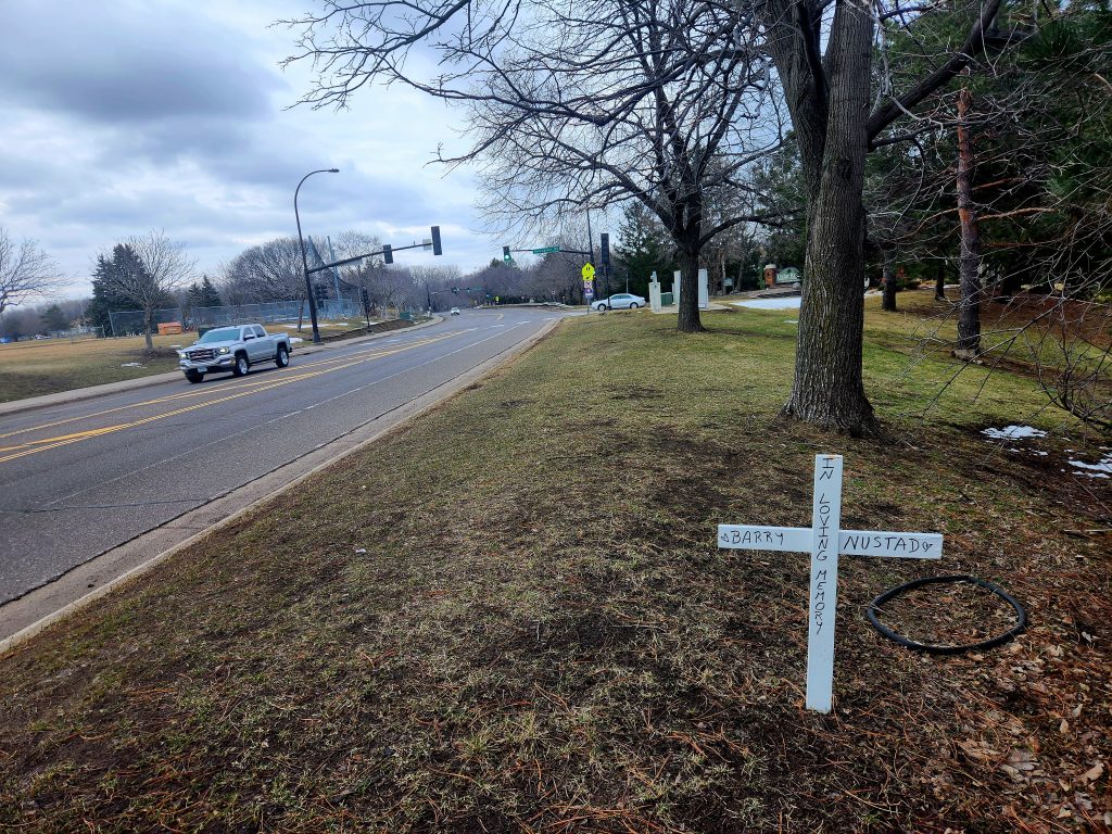
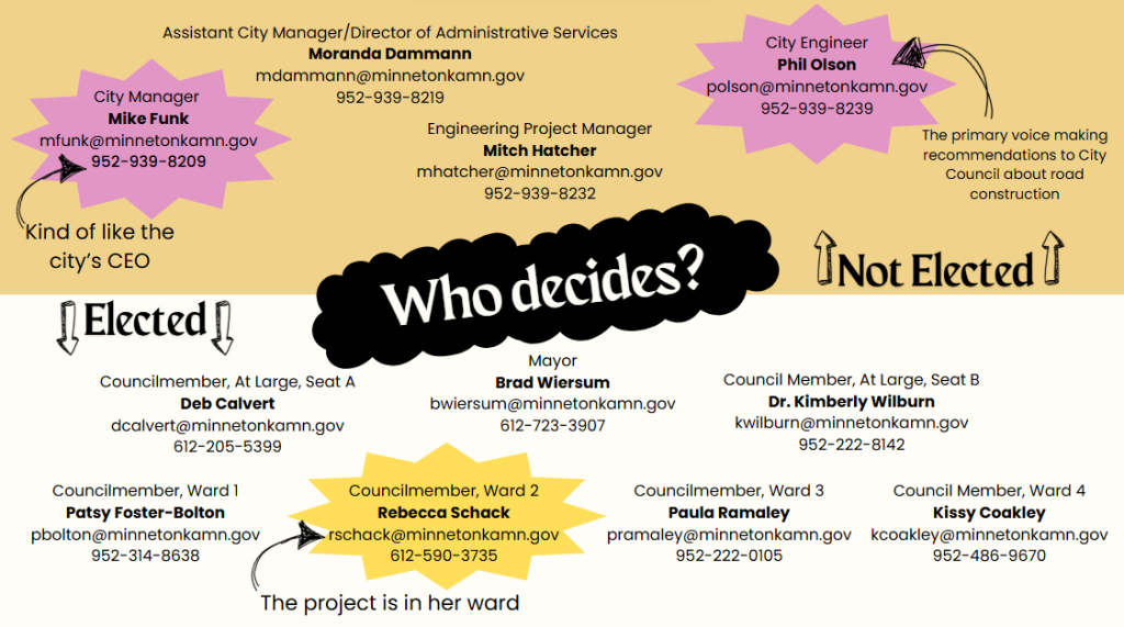
My partner and I first reached out to Minnetonka Mayor Brad Wiersum in May 2024 to ask about plans to address safety issues on Cedar Lake Road, citing the excessive speed, lack of protected infrastructure, and the then recent death of Barry Nustad. The response we received implied that Minnetonka intended to increase enforcement of the 40 mph speed limit and do something about the faded paint on the road. If enforcement happened, we never witnessed it, and the faded paint was never addressed.
In February 2025, after nine months and another crash — this time injuring a child — we learned that the city of Minnetonka is planning construction on Cedar Lake Road for the summer of 2026. Additional emails and phone calls revealed that the city intends to simply repave Cedar Lake Road and has no plans to effectively address the safety and livability concerns that plague the project area.
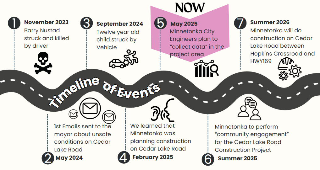
The city engineering team, or more likely a contractor they hire, is going to “collect data” and perform “public engagement” for the project in the coming months, according to their project web page. I am working to organize members of my community to encourage the city to incorporate traffic calming and protected infrastructure that is intentionally designed for people outside of cars. Moving away from car dependency is an immense uphill battle, due to a system of laws, standards and cultural norms that serve to maintain the status quo.
The Status Quo Is Hurting Us
Low-density suburban sprawl, which serves as both a cause and an effect of car dependency, dilutes power by putting physically longer, more dangerous distances between community members and the people who make decisions on their behalf. Obstacles created by car-dependent sprawl are insurmountable for roughly one-third of Americans who cannot drive or don’t have access to cars. At least half of the students attending the three Hopkins schools on Cedar Lake Road are not old enough to drive, meaning that they rely on caregivers, public transportation or transportation provided by the school district to get to and from school or anywhere else.

I ride through Hopkins High School’s main parking lot daily on my way home, at around 2:30 p.m., an hour before dismissal, and the lot — with over 540 parking spaces — is rarely more than two thirds full, indicating that students who drive must compose a small percentage of the 1,991 member student body.
The school district bears the unfair burden of providing transportation for non-driving students because of a system that limits mobility to only those old enough, wealthy enough and physically able to drive cars. This situation will leave many Hopkins district students and caretakers scrambling to arrange transportation when the district increases the “no-bus-zone” for the 2025-2026 school year in an attempt to address budget shortfalls. The district is also altering student schedules — moving two elementary schools from a 7:50 a.m. to 2:20 p.m. schedule to a 9:30 a.m. to 4 p.m. schedule, a major disruption for families who rely on the consistent schedule of child care and transportation.
The Hopkins students are further disadvantaged by the disconnect between their school district and the city of Minnetonka. Cedar Lake Road is owned by the city of Minnetonka, but the three schools on Cedar lake Road belong to the Hopkins School District. A meeting with Hopkins High School administrators and staff on May 1, 2025, confirmed that no one from the school had been contacted by the city of Minnetonka about the upcoming construction.
The people making decisions about how roads are constructed and reconstructed generally come from the wealthier, car-owning class. Elected leaders and city engineers believe that “most people drive” and that our current system is unchangeable. They have a hard time empathizing with non-drivers because car dependency is so deeply woven into their way of life.
Car Dependency in St. Louis Park
The commitment to car dependency is not unique to the City of Minnetonka. In my city, St. Louis Park, recent and upcoming construction projects demonstrate a fierce commitment to prioritizing the movement and storage of cars over health, safety and comfort for people and the environment.
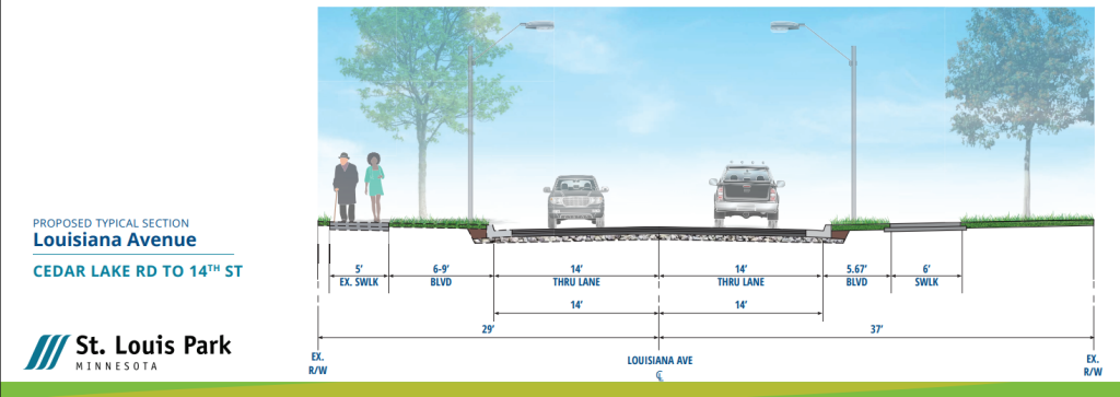
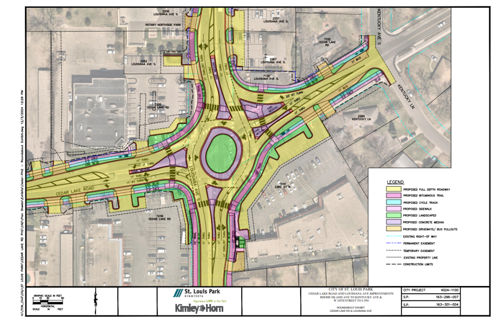
According to the National Association of City Transportation Officials (NACTO), lanes wider than 11 feet “may cause unintended speeding and assume valuable right-of-way at the expense of other modes,” but the reconstruction of Louisiana Avenue, planned for the summer of 2025, includes 14-foot-wide lanes for cars and omits most traffic-calming measures and pedestrian features in excess of the minimum required by ADA standards. The St. Louis Park City engineer’s argument (about 19 minutes in to the recording) for constructing the 14-foot-wide lanes — “12 and a half feet plus a one-and-a-half-foot curb reaction distance” — is that Louisiana Avenue is an “arterial street” with a fire station. They say that FHWA standards require a minimum of 12-foot wide lanes, but, according to Louisiana Avenue’s classification as a “minor arterial,” 12 feet is actually the maximum recommended by FHWA. By implementing the 12-and-a-half-foot wide lanes, St. Louis Park is violating FHWA guidance.
The city engineer noted that Louisiana Avenue is the only city street that runs all the way from Interstate 394 to Excelsior Boulevard, implying that it is an important thoroughfare for cars and trucks, but not people. The only other connections that run as far north and south within St. Louis Park are Highways 100 and 169, roads that exclude people outside of cars, not just physically, but also legally.
Instead of designing Louisiana Avenue for the people who live in the homes, work at the businesses and play in the parks along its length, the city of St. Louis Park forced a business to relocate so they could demolish their original building to make room for a roundabout large enough to accommodate semi trucks moving at 30 miles per hour. St. Louis Park’s City engineering department has framed this as a choice between preserving trees or adding a protected bike lane, when the real choice was between preserving the status quo of car dependency and making a real improvement to the street for the people who live and play near it.
Beyond the Western Suburbs
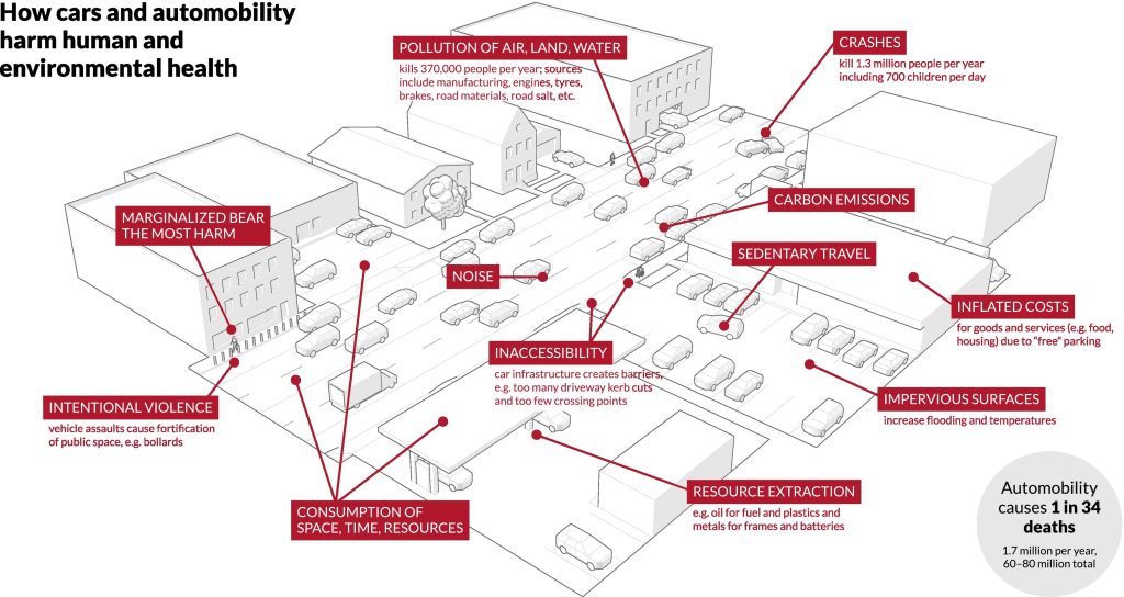
Almost every government entity in the United States, from local park boards to the federal government, bolsters a system that serves to solidify cars as Americans’ preferred method of transportation. This is a problem because cars are an extremely harmful mode of transportation and are far from optimal for use in cities. Approximately 1.67 million people die because of the pollution and violence from automobility, and another 102 million are injured by motor vehicle crashes annually, yet our governments are reluctant to address these harms fearing potential negative impacts to economic productivity.
Narrow interpretation of article XIV of the Minnesota state constitution has resulted in the use of state funding to almost exclusively serve the needs of automobiles and trucks instead of serving the needs of all Minnesotans, regardless of their access to driving. Joe Harrington from Our Streets (also a board member and columnist for Streets.mn) explains in this article how an amendment to the state’s constitution in the 1920s — which created Minnesota’s public highway system — has been interpreted such that funds have only been used for “pavement and asphalt for cars and not for any pedestrian, bicycle or transit infrastructure within the highway right-of-way.” Funding that can and should be used to support all modes of transportation has instead been almost exclusively used to build and expand roads for cars at the expense of pedestrians, cyclists and transit users. The consequence is a costly, inefficient system that is responsible for the deaths or serious injuries of 225 Minnesota pedestrians annually.
In late April 2025, the Minnesota House of Representatives passed a transportation bill that cuts public transit funding by $40 million and delays implementation of legislation passed in 2023 that would require the Minnesota Department of Transportation to address climate impacts from highway construction projects. The climate impact of highways law, enacted by the Legislature in 2023, would make it illegal to build new or expand existing highways without accounting for their climate implications, but our current Legislature could delay implementation by another three years. This delay would not only damage Minnesota’s ability to tackle climate goals, but it would also hurt the state’s ability to reduce “overhead costs and infrastructure liability in state and local budgets.”
Also this legislative session, the Minnesota Senate’s State and Local Government committee voted six to five with one abstention against a bill that would address car dependency by limiting local governments’ abilities to enforce parking minimums and aesthetic requirements that serve to restrict the construction of more housing within cities by making it more costly and legally cumbersome to build. One of the key votes against the bill came from Senator Ann Johnson Stewart (DFL-Wayzata), the senator representing Minnetonka, who slouched in her chair as she quietly voted “no” against the bill’s passage.
Other lawmakers opposed to the bill’s passage argue that the state should not be meddling in the affairs of cities when it comes to these mandates, ignoring the fact that cities have used the power of zoning to stall development where it should be happening, fueling Minnesota’s housing crisis and forcing sprawl into agricultural and previously forested lands. Even though 76% of Minnesotans agree that the affordable housing crisis requires state action, these senators sided with city leaders who’ve thus far failed to make even a small dent in the statewide affordable housing shortage.
What Can We Do?
Learning about how the current system is working to harm and isolate us can be a real bummer, but there are various actions you can take to help steer us away from car dependency.
Specifically for Cedar Lake Road in Minnetonka you can:
- Join the team fighting to make the City of Minnetonka make Cedar Lake Road safer and share your experience using this Google form. Our team, with support from Access Hopkins and the Bicycle Alliance of Minnesota, will work to create an organized group to communicate our message to decision makers. We can use all the help we can get!
- Show up to city events and let decision makers know that you want to see safety for pedestrians, transit users, and cyclists prioritized in their design.
- Minnetonka’s informational open house: to be scheduled for summer 2025
- City council meetings: TBD
- Email or call Minnetonka’s decision makers and staff to let them know you want Cedar Lake Road to serve everyone, not just drivers.
If you care about this issue, but don’t feel like you have a close enough connection to Cedar Lake Road or the western suburbs, you can join and support the following organizations that are also addressing car dependency and sprawl:
- Streets.mn
- Our Streets
- Neighbors for More Neighbors
- The Bicycle Alliance of Minnesota
- Move Minnesota
- The North Star Chapter of the Sierra Club
Another great way to engage is by getting more involved in your local government and joining local groups working to tackle all kinds of local issues — from housing to food insecurity. Depending on where you live, your local government may have different opportunities to engage, but engaging as a group can be a lot less intimidating than speaking up individually. A great local media producer once told me: “If you’re biking, walking, taking the bus anywhere, you need to be political about it.”
This statement has never been more true.