
Editor’s note: This is the first in a two-part series on how, or whether, cities and planning agencies consider all modes of transportation when they’re mapping out infrastructure.
It may surprise you that many planning agencies don’t consistently use bike and pedestrian counts to guide planning and policy work in the same way they use car counts. It’s a clear gap in our understanding of how we move across all modes of transportation.
In the prevailing car-centric transportation logic, transportation engineers and agencies count cars obsessively.
- Traffic studies document every vehicle passing through intersections and corridors.
- Engineers forecast future car volumes with sophisticated and expensive models.
- Agency staff and officials cite these numbers to justify or block infrastructure changes.
We put so many resources into studying the movement of cars on a structural level, but we do not do the same for pedestrians or bicyclists.
While some cities already do some bike and pedestrian counting to inform project designs, it is mostly done at the surface level. Think Minneapolis and St. Paul, where many bike and pedestrian projects, like the Summit Avenue Regional Trail plan in St. Paul and the reworking of Bryant Avenue in Minneapolis.
In both cases, city planners are designing infrastructure that makes safe and connected networks for pedestrians and cyclists a planning priority. But even on these projects, the kind of data accessible to planners and the public is very limited, presenting a gap as we continue to invest in complete streets and multimodal infrastructure.
How Do We Count Bicyclists and Pedestrians Today?
Some of the Twin Cities’ most high-profile bike and pedestrian projects, like Summit and Bryant, have surprisingly little bike and pedestrian travel data underpinning them.
The Summit Avenue Plan includes just a handful of bullet points on existing bike and pedestrian counts across a nearly 300-page document.
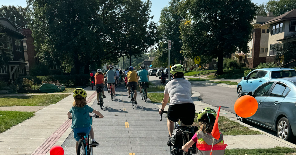
Bryant Avenue, one of Minneapolis’ most beloved bike facilities that has transformed a car-dominated street into a multimodal corridor, stands as evidence that when we build safe infrastructure for nonmotorized transportation, people use it. Other projects, like First Avenue in Minneapolis from Lake Street to Franklin Avenue, are mimicking Bryant’s design.

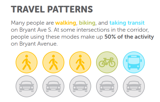
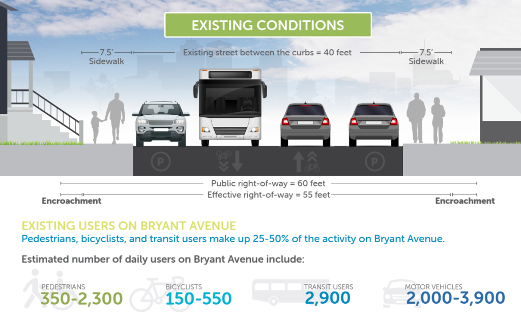
The Bryant Avenue planning documents showed some convincing figures to justify prioritizing bikes, pedestrians and transit users in the street design. These plans identified that pedestrians, bicyclists and transit users make up 25% to 50% of the activity along Bryant Avenue, relying on data from a 2016 pedestrian and cyclist counting report. They used these statistics to make the case that the street design should accommodate those modes too, addressing an infrastructure mismatch where cars and parking were previously over prioritized.
But that same report’s analysis of travel patterns focuses more on cars than on the way people who bike or walk along Bryant interact with the rest of the neighborhood network. This shortcoming is acknowledged, stating that, given the limited pedestrian and bicycle information, more data should be collected in 2018, but it’s unclear if this data collection occurred. The Summit Avenue plan doesn’t mention this shortcoming at all.
As the Twin Cities builds more projects like Bryant Avenue, including the Lyndale Avenue project that is garnering a lot of public interest, it’s time to get more serious data at the systems level, to articulate the benefits of these projects and to understand how they change the way we move.
What Data Is Needed?
To successfully study streets — like Bryant Avenue and similar projects — as public spaces and case studies to justify future investments, we must go beyond the anecdotal experiences of roadway users along the corridor.
First, we need to count cyclists and pedestrians consistently. Understanding people’s revealed preferences through travel patterns will give us a holistic view of how our network functions, what gaps exist and how we can plan for future investments. This means gathering data, more consistently and comprehensively than the city, some counties and the Minnesota Department of Transportation (MnDOT) have done in the past.
Having an understanding of these counts can be valuable as a way to measure the before and after impacts and to justify future investments. The Bryant Avenue case supports this logic, where planners argued that, since 25% to 50% of users are biking, walking, rolling and taking transit, the 80% of the space dedicated to car travel and parking, is a mismatch that needs to be addressed.
To understand how streets like Bryant or Summit really function, counts alone won’t reveal deeper patterns. If we don’t understand the why behind those counts, we run the risk of misunderstanding how people move and subsequently fail to craft projects and policies to facilitate that movement.
In musing about these questions, I wonder:
- Who bikes on Bryant Avenue (demographically)?
- Where are people along Bryant Avenue traveling to?
- Are they riding the whole length of the street corridor or are they entering and exiting the street at different points?
- If they are riding a bike, what kind of bike are they riding?
- Are they commuting to work or school, or riding for recreation or exercise, or to access local businesses or daily needs?
- Where are the common destinations and origins for those biking or walking along Bryant?
- What gaps do they identify in their own travel through the space that could be filled through new infrastructures or remediated through traffic calming?
- What times of day are people traveling?
- How do travel patterns change seasonally?
- Do people stop to spend money on their trips? Has the new infrastructure had a positive impact on local businesses?
Of course, this is not an exhaustive list, but the answers to these and other questions would benefit the planners for the upcoming (and still controversial) Summit Avenue project in St. Paul and on other projects. More broadly, this would help illuminate new approaches to provisioning active transportation infrastructure as public space.
What Is a ‘Public Space’?
It’s important to remember that streets, as well as any bike or pedestrian facilities within, beside or near a street, are public spaces.
Acknowledging this means expanding our methods beyond simple counts or similar statistics. Public life studies pioneered by Danish urban designer Jan Gehl, which the Metropolitan Council and other units of government are considering adapting, provide a mixed-method approach for understanding how places are designed and function to create cities for people.
San Francisco, among many other cities, regularly integrates the results of such studies into their planning process for public spaces and multimodal facilities. The city has a comprehensive manual to inform others on how to conduct this work, as does the Gehl Institute’s resources for mayors. Some similar work has been done in academic contexts, like this study of successful city parks in St. Paul.

Unlike traditional counts of people moving through spaces by a variety of modes, Gehl’s methodology observes not just how many people move through a space, but how they interact with it, asking basic questions like who, where, how long, how many (people).
If we study streets as public spaces, we can understand how they work and how people really use them, and most importantly, why.
We need to grow a deeper understanding of these interactions and human needs — both movement and stationary activity — if we want to build streets for people and restore the damage that car culture has dealt our cities.
Failing to do so can lead to public spaces that hinder urban vibrancy, like the ongoing struggles with Nicollet Mall’s street redesign. Succeeding will help us leverage project or city-wide examples from Minneapolis and other communities to inform regional and state policy, design guides and best practices in a variety of contexts.
Perhaps unsurprisingly, this methodology is expensive and time-consuming, and it extends beyond the budget or scope for any one individual project. In part two of this piece, we’ll look at the Met Council’s pivot toward supporting such work through high-level, local, comprehensive plans.
Editor’s note: “Street Views” appears in Streets.mn twice monthly. Respond to columnist and board member Joe Harrington directly at [email protected]. You may also comment at our Streets.mn pages on Bluesky and Facebook.