When I first stood on the shoulder of Robert Street and looked across the slabs of limestone and corrugated metal that now face the Mississippi, I felt disoriented. Where a row of porches, stoops and corner stores once lived, there is now a river of traffic, industrial yards and a patchwork of fenced-off parking lots. The street itself, once the spine of the West Side Flats, became the conduit for U.S. Route 52 the official artery that transformed this neighborhood from a neighborhood to a regional conduit.
U.S. Route 52 is a long, multi-state highway; in the Twin Cities it historically used Robert Street as its path through south St. Paul and West St. Paul before being shifted onto a more freeway-style alignment later in the century. Robert Street, a main thoroughfare, carried buses, trucks and the rumble of intercity commerce so routing US-52 there seemed at the time like a sensible modernization.
A neighborhood before the highway
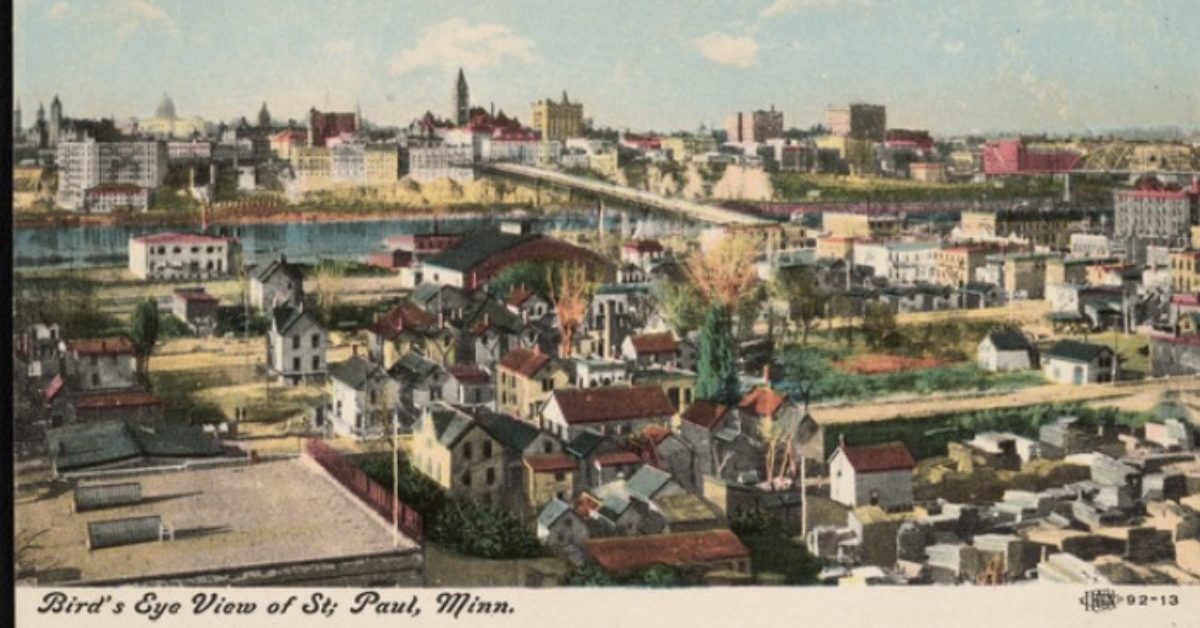
For about a century the lowlands below the bluff known locally as the West Side Flats were a dense, polyglot neighborhood — immigrant communities, small businesses, churches, and schools. Postcards and aerial photos from the early 20th century show rows of wood-frame houses hemmed between riverfront industries and rail yards. The Flats were a working-class place of many origins: Irish, Jewish, Polish, Italian, and by mid-century the Mexican American community had become a central presence in daily life. The Flats were flood-prone, lying low along the Mississippi River, and in 1952 the river overflowed its banks, inundating homes, businesses and streets. Despite the risk, families settled here because the neighborhood offered affordable housing, proximity to riverfront jobs and established immigrant communities.
After the flood of 1952, municipal authorities and federal flood-control actors increasingly treated the Flats not as a living neighborhood but as underused land in need of mitigation and “better uses.” Engineers and city planners, looking at the same maps residents used to find friends and funerals, saw levees, parking and industry. That recalibration of what counted as “productive land” set the table for a transformation that reached its climax in the 1960s. After the catastrophic 1952 Mississippi River flood submerged nearly the entire West Side Flats forcing thousands from their homes, destroying more than 200 buildings and leaving the neighborhood under several feet of water for days, city officials argued that the Flats were no longer fit for residential life. Planners pointed to photographs of stranded families being evacuated by boat and to waterlines halfway up storefront windows as proof that industrial redevelopment was the only “rational” use for the land.
“It killed a community” – Voices from the Flats
In the Minnesota Historical Society’s oral history archives, one former resident describes keeping a chipped blue enamel pot, the only object her family salvaged after the 1952 flood, as a reminder of “a whole neighborhood washed away.”
But in recent years, community researchers have worked to reconstruct the story and to give space to the people who lived it.
“It was like the community was just knocked down because they wanted to knock it down… There will never, never, never be another West Side like that.”
— Linda Castillo
Linda Castillo is a former West Side Flats resident whose family was displaced when her house on Minnetonka Street was demolished for Highway 52 and industrial development. In a public oral history profile, she recounted how Port Authority agents from the Saint Paul Port Authority, the city’s economic development agency responsible for land acquisition and industrial redevelopment, approached her family with relocation offers before demolishing their home for the Riverview Industrial Park. The Port Authority, created in 1929 to stimulate commerce and expand Saint Paul’s tax base and later authorized to develop inland industrial sites, played a central role in acquiring and clearing the West Side Flats for industrial use.

“It was like the community was just knocked down because they wanted to knock it down… There will never, never, never be another West Side like that,” she said, describing the bulldozers that arrived while promises of fair compensation went unfulfilled. Her memories capture a neighborhood once full of life families, corner stores, and shared celebrations now replaced with industrial lots and Highway 52.
That loss, however, was not unique to her family. George Avaloz, whose home was among the 480 structures razed in the early 1960s, remembers the sequence of events with clarity: repeated flooding provided officials a pretext to relocate residents, but the underlying goal was industrial development. “Every other year they had the flood down here and the city or the state never did anything about it. And then they made my family move because they were going to build the industrial center down there, and then they put the flood control in,” he said.
For Avaloz, the message was unmistakable: the neighborhood’s social fabric came second to infrastructure and commerce. “It killed a community,” he added, echoing the sentiment that Linda had voiced about the broader impact on lives and memories.
“The demolition of our homes, the clearing of streets, the erasure of our community, it killed a community,” he said, reflecting on a neighborhood that had once pulsed with businesses, churches, and families.
“What made this community special was that growing up, we really were truly diverse…we kind of just all grew up together.”
— Don Luna
Growing up amid the mix of Lebanese, Syrian, African American, Hispanic, Jewish and white families that made the Flats uniquely interwoven, longtime Flats resident Don Luna remembers that the social fabric was as much a part of daily life as the rowhouses themselves.
“What made this community special was that growing up, we really were truly diverse…we kind of just all grew up together,” Luna said, recalling that residents didn’t just live side by side, they watched out for one another. But when city planners began buying properties for the industrial park, that web of relationships began to unravel. “They wanted the land. The city was using the floods as a reason to move everybody.”
The highway’s route: maps that mattered
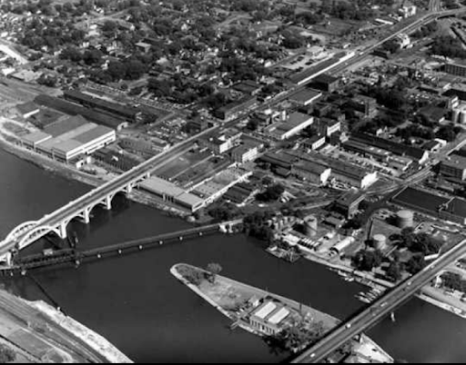
Maps from the period show two simultaneous logics at work: flood-control and industrial development. The city, the Port Authority and federal agencies cleared swaths of the Flats, built flood walls and parceled out land to industrial uses that promised tax revenue and jobs. Highway planners wanted a direct, uninterrupted corridor; port and city officials wanted flood-protected industrial sites. Together these plans undid the social map of the Flats. The physical joining of flood-control engineering, port development and highway routing is critical to understanding why whole blocks were removed rather than retrofitted or protected in place.
Credit: Minnesota Historical Society
What the numbers show (and what they conceal)
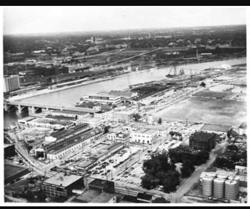
In 2023–24, community organizations and researchers moved from documenting what was lost to making demands about what should be done now. The community-driven research compiled by the West Side Community Organization (WSCO) and Research in Action documented the scale of the displacement: between 1960 and 1964, hundreds of households were forced to leave the Flats to make way for the Riverview Industrial Park and associated infrastructure.
The research report compiles primary documents, Port Authority memos, city relocation payment records, and maps that show systematic undervaluing of property and inadequate compensation for residents. The report found that the Port Authority and city prioritized land for industry and flood infrastructure while giving residents measly relocation stipends and little long-term support.
Modern reporting has begun to amplify those archival claims into human stories. A 2024 article in the Sahan Journal recounted oral histories and described the emotional toll of seeing houses razed and community life dissipate. One longtime West Sider, Castillo, described how entire blocks were emptied and replaced with warehouses and pavement places that pay taxes but do not hold birthdays or funerals. The Sahan Journal article also chronicled recommendations from the WSCO report.
St. Paul’s West Side as a case study in a national story
What happened on the Flats is part of a pattern that played out across American cities in the mid-20th century: highways, urban renewal and industrial redevelopment converged to remove working-class and often non-white neighborhoods. Federal highway policy and local redevelopment often treated neighborhoods as obstacles to circulation and capital, not as communities with social capital to protect. The Federal Highway Administration’s own histories and many city studies across the country acknowledge that interstates and highways cut through minority neighborhoods, shifting demographics and economic vitality. In St. Paul, as elsewhere, the results included concentrated environmental burdens, fractured social networks and economic dislocation.
In the West Side, Mexican American families, Jewish institutions, small-scale industry and the neighborhood’s distinctive street life were erased in a way that is traceable through plat maps showing property lines before clearance (Minnesota Historical Society, Plat Maps Collection), tax records documenting hundreds of displaced households (St. Paul City Archives, 1960s Property Tax Rolls), flood-control plans drafted by the Army Corps of Engineers (U.S. Army Corps of Engineers, St. Paul District Flood Control Records) and oral histories collected by the West Side Community Organization.
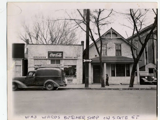
Archival city directories and early-1960s newspaper ads show a once-vibrant local economy in the Flats grocery stores, laundromats, restaurants and bakeries that served a close-knit clientele within walking distance.
Credit: Minnesota Historical Society
When the city cleared blocks for the Riverview Industrial Park and prioritized through-routes for Route 52, those shops lost the everyday foot traffic that sustains small retailers. Some business owners took relocation stipends and a few reopened elsewhere on the West Side or in the surrounding area, but many closed. The economic ripple was profound. When blocks of homes and small businesses on Minnetonka Street and Stryker Avenue were cleared for the Riverview Industrial Park, corner stores, bakeries and laundries lost their walking-distance clientele, forcing some to close entirely. City relocation payments often covered only moving costs, not lost business capital, leaving families with depleted savings. Archival tax records show property values in the surrounding blocks fell sharply after clearance, reducing long-term household wealth. Oral histories collected by the WSCO indicate that displaced families struggled to rebuild businesses elsewhere, and some never fully recovered economically, a pattern reflected in census data showing persistent lower household incomes in the Flats’ former neighborhoods for decades.
One concrete way to see the effect is to compare pre-clearance business listings with the industrial leases that replaced them. Documents preserved at the Minnesota Historical Society and summarized in neighborhood reports show that the Port Authority marketed the newly cleared Riverview parcels to larger industrial tenants, offering flood-protected land suitable for tax-producing operations. The calculus was fiscal: immediate tax gains in exchange for removing neighborhoods that, on paper, were problematic. But for families and the small-business ecosystem, the trade-off was often permanent.
The WSCO report, drawing on archives and oral histories, documents relocation payments that ranged widely but were often insufficient to cover the real costs of moving and rebuilding. Some homeowners received between $35 and $1,000 in relocation assistance (in the terms of the era).
Environmental and infrastructural consequences
The Riverview Industrial Park introduced more freight traffic, truck idling, industrial runoff and reduced green space. The WSCO team documented that the Flats and surrounding areas now host a concentration of industrial sites and remediation projects listed with the Minnesota Pollution Control Agency (MPCA) and linked to the industrial history that replaced residential life. Environmental justice advocates note that when lower-income and immigrant neighborhoods are cleared for industrial uses, the future costs of remediation and health burdens are often borne by the same populations who were displaced, or by those who could not leave.
This pattern is visible across U.S. cities: when highways carve corridors through urban neighborhoods, they often bring increased air pollution from truck traffic, constant noise from multi-lane highways that studies show raises stress and cardiovascular risks, and heat-island effects where asphalt and concrete replace green space, making formerly shaded streets hotter in summer.
In St. Paul, the Riverview Industrial Park and Robert Street corridor concentrated truck traffic and industrial runoff in the Flats, documented in MPCA legacy site lists and WSCO environmental assessments, showing that the same residents displaced decades earlier also face ongoing environmental burdens. In St. Paul, those cumulative impacts are not merely theoretical; they are traceable through MPCA legacy site listings (MPCA Legacy Contamination Map), city planning and Port Authority documents from the 1960s–70s (WSCO Flats Research Report), and oral histories collected by the West Side Community Organization (WSCO Stories from the Flats).
What rebuilding might look like
The WSCO/Research in Action report goes beyond history-telling to offer policy recommendations, including public acknowledgement, investment in local housing and green space, and reparative measures for descendants of those displaced. Local reporting has amplified these calls and there is momentum to at least begin the difficult civic work of repair: memorials, plaques, community benefit agreements tied to new development, and targeted investments in West Side infrastructure. Repair, from this vantage, is not simply returning property but rebuilding the civic ties that made neighborhoods resilient: schools, public spaces, affordable housing and funding for cultural institutions. It is a long, complicated arc requiring municipal will, port authority cooperation and perhaps state resources, but advocates insist that it is a moral and civic necessity.
Practical proposals emerging from the community research and local discussions range from small to structural. Creating interpretive signage and a public exhibit at the Minnesota History Center that tells the West Side Flats story; naming a public plaza or park to honor displaced families; dedicating some Port Authority revenues to housing funds for descendants; and adopting a community-led planning process for any future development of the Flats area. These moves are about memory and materiality at once: a plaque does not undo lost homes, but combined with housing investments and environmental remediation it can be part of a credible package of repair.
There are also design interventions to reduce the neighborhood-cleaving effects of highways: better pedestrian crossings, lane-calming, truck routing that minimizes local exposure and the creation of green buffers. State and municipal transportation agencies have experience retrofitting arterials to improve neighborhood livability; nothing is simple, but precedent exists. The Minnesota Department of Transportation (MnDOT)’s project pages and historic transportation studies document that highway alignments and river crossings have been reconfigured before but these technical fixes must be paired with social investment.
This publication was made possible in part by the people of Minnesota through a grant funded by an appropriation to the Minnesota Historical Society from the Minnesota Arts and Cultural Heritage Fund. Any views, findings, opinions, conclusions, or recommendations expressed in this publication are those of the authors and do not necessarily represent those of the State of Minnesota, the Minnesota Historical Society, or the Minnesota Historic Resources Advisory Committee.