
Regrets! We all have them. One regret that I maybe have, and that a bunch of other people like me maybe could have, is that we all sort of got distracted several years ago. You probably know about the various snafus with the Green Line extension out to Eden Prairie (maybe?) and how there was the whole thing what with routing it through an existing rail corridor to save money and time for suburban commuters, and then some other stuff happened and it turns out that that was probably a bad idea.
Right around the same time the Green Line extension was starting to go to pot, three entire years ago, Hennepin County was going through the process of choosing a Locally Preferred Alternative for the Bottineau Transitway. This is the northwesterly-aiming transit corridor heading out of Downtown Minneapolis, through North Minneapolis, and hitting a couple first-ring suburbs before ending up in either Brooklyn Park or Maple Grove. In retrospect, it is unfortunate that maybe we focused on complaining about Uptown and beating a dead horse that was buried under a light rail tunnel under a bike trail–we probably could have been paying more attention to what was going on in other parts of town.
(Interpret that sentiment however you want!)
Anyway, these two extensions of the existing Blue and Green Lines in the Bottineau and Southwest transitways are pretty similar and went through a similar process. The Blue Line extension is currently projected to begin construction in 2018 and open in 2021.
 The options were winnowed down to two possible types of routes on either end. Bottineau’s two suburban options were to have terminated at either Arbor Lakes in Maple Grove or a literal field (more on that later) in Brooklyn Park.
On the city end, the line was to leave Downtown Minneapolis along Highway 55 (Olson) and then either turn north at Penn Avenue, heading up to West Broadway through the Northside and then over to a Burlington Northern Santa Fe railroad corridor, or it could continue down Highway 55 and link up with the same railroad corridor further south, traveling through Theodore Wirth Park up north. You can make a headless stick figure as you mentally visualize the route options.
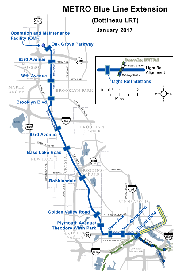
Here is a professional-looking map (see further down for a more up to date map of the route) to help you visualize it, though the MS Paint one may help you make your decision also.
Alternatives (Source: MinnPost)
On the suburban end, we went with Brooklyn Park over Maple Grove. On the city end, as is tradition, we chose the option skipping the parts of the city with lots and lots of transit riders, preferring to try to build a train through a park. Though of course, it is more complicated than that!

Penn Avenue
The Penn Avenue option (like Nicollet Avenue!) was not fantastic. Currently a two lane county road, putting light rail on it at grade while keeping two driving lanes would have required all sorts of property acquisitions, as you can see on pages 23 through 26 of this large PDF. Penn Avenue itself is also a bit far west of the remaining big commercial drag on West Broadway, and the route probably wouldn’t pick up a whole lot more ridership than the existing Route 19 bus.
It should be pointed out that the lack of imagination inherent in these two options is mind-boggling, especially when you consider that we’re talking about a decades-long planning process for a 100 year investment.
“Either tear down nine blocks of houses in a low-income part of town–and good luck owning those optics–or build the train through a park a mile away from the center of the most transit-dependent population in the state,” they said.
Is it because Hennepin County and its consultants have been intentionally picking bad urban options and fudging ridership and cost estimates to support routes that favor suburban commuters in accordance with transit philosophies from the late 1980s? Who knows! That would be crazy. This isn’t House of Cards; Frank Underwood had a grade-separated heavy rail line on which to toss Zoe Barnes.
But this is the route we went with. For what is currently estimated at a hair under $1 billion dollars, what will we get? In the spirit of adventure on a beautiful summer day, I decided to go check it out, riding from Oak Grove Street (where I live) in Minneapolis to Oak Grove Parkway in Brooklyn Park.
Highway 55 (Olson)
As part of the project, Highway 55 will see a makeover, sort of like what happened with University Avenue in St. Paul when the Green Line was built. This is very much a good thing and will help knit two parts of the Northside back together. At present, it is very much a state highway.
 Look at that! Is that spitting distance from Downtown Minneapolis or a business bypass in Isanti County? These first couple stops, Van White and Penn, are a lot like much of the existing Blue Line along Hiawatha Avenue. Not intuitively transit-ready next to the stations, but with lots of room for improvement and many walk-up riders in surrounding neighborhoods even if no new development happens.
After those first two stations, though? Not great!
Abandon All Hope, Ye Who Pass Xerxes Avenue
The line swings north at the border with Golden Valley, and drops to run parallel with an existing rail corridor through Theodore Wirth Park. The route is technically in Golden Valley at this point, but it’s on the other side of the park, faraway from any substantial amount of walk-up riders from Golden Valley. There are no park and rides planned at either potential station (we don’t know if the Plymouth and/or Golden Valley Road stations will even be built) and in any case it’s pretty hard to imagine any substantial number of people in wealthy Golden Valley getting on a bus to go wait at a train station to take a train downtown when they can just drive the whole way in ten or fifteen minutes.
Also, hey, check this out.


That’s an old railroad tie in the water! (current tracks in background)
 Looks marshy! You’ll remember the recent $350 million dollar cost increase on the Green Line extension largely stemmed from unexpectedly crummy soils in Eden Prairie. The plan here involves existing right-of-way, and the freight rail tracks will be shifted over and the light rail tracks will be plopped next to them. The rail corridor is quite old.
A very helpful man from Metro Transit with an unenviable job explained to me after a station area planning open house that the railroads have been basically just dumping rocks here for 100 years to build up the berm the tracks sit on. Standards these days are somewhat higher. The cost estimates we have are based of off 1% engineering–what will they find in the other 99%? (Hopefully oil!!!) The very helpful man with the unenviable job said that people are out doing soil sampling right now trying to figure out just what we’re going to need to build.
A Bright Spot
No qualms with Robbinsdale. Building a train station on the edge of a first-ring suburb’s walkable downtown is a good idea. This should probably be the terminus of the line.
Also, is it crazy there’s no bike shop in Robbinsdale? I was hoping to stop and get some air but no such luck. A business opportunity exists here.
Crabgrass Frontier
Out past Robbinsdale, things are less rosy. The Bass Lake Road and 63rd Avenue stations are in the existing rail corridor, next to Bottineau Boulevard. Bottineau in this part of town is a six lane county road with no shortage of car traffic. It was not particularly pleasant to bike along, and is flanked by auto-oriented commercial uses, and residential uses that actively hide from the road. A retention pond at the southeast corner of Bottineau Boulevard and 63rd Avenue requires pedestrians and cyclists to take a cockamamie route to cross Bottineau from the south.
One potential wild card is the Crystal Airport between the Bass Lake Road and 63rd Avenue stations.

Crystal Airport is across Bottineau Boulevard from the rail corridor
Building a bunch of electrified overhead catenary across the street from and under an approach to an airport at which casual pilots are landing Cessnas? It would be shocking if no one checked that out ahead of time, so we’ll assume they did. And if the airport closes in the near or medium-term future, maybe this would be a site for large-scale transit-oriented development. Could be cool.
After 63rd Avenue station (which already has a structured ramp at a park and ride) the line crosses Bottineau Boulevard and veers over to the Brooklyn Park part of West Broadway. There’s a station at Brooklyn Boulevard, which is surrounded by strip malls and big box stores with huge parking lots.

Looking west down Brooklyn Boulevard towards West Broadway.
Maybe it’s easy to imagine one of those boilerplate sprawl retrofit watercolors and think about what this intersection would look like twenty years after a light rail station is built. Maybe. Does that often happen in a lot of places? Maybe not.
Keep biking down West Broadway, and you’ll find yourself at the next station, at 85th Avenue. Cool government decisions abound here, where a large vacant lot at the northeast corner is currently fenced off and has some kind of construction project going on.
 What is it? A one story building. Huh okay, what will be in it? Funny you should ask–it’s a new library. Wait, they’re building a brand new one story library on a vacant lot right next to a planned light rail station? I guess! Okay, remind me: who runs libraries again? Hennepin County. The same people who sited the train station there? Shouldn’t they be thinking long-term about investments on this site? You would think that, sure!
Good joke aside, this isn’t a completely terrible spot for a station–North Hennepin Community College is across 85th Avenue from the library site, which is a good thing to put on the light rail system, and while relatively unwalkable, there is a lot of dense-ish residential within technical walking distance of the station. Though it is maybe a red flag that there is a Mills Fleet Farm 13 minutes away from the station by foot.
Continuing north on West Broadway, we arrive at 93rd Avenue station. At the time of the draft environmental impact statement, a park and ride was planned for this spot on the northeast corner. As it turns out, there is a brand new building there!

Building on the right isn’t even on Google Maps yet!
When you snooze you lose, and so the park and ride at this location was scrapped in favor of building one huge park and ride at the final stop. A lot on the southeast corner which was vacant in the DEIS is also currently under construction–a church is going there. Not sure why you’d even include a station here without a park and ride.
At this point in the ride, we’ve entered Dreamland–a new term we could use to describe literal farmland that we are building light rail to. Light rail, a mode of transportation with high capacity and frequent service, running pretty much all day except late at night. The public sector is building that through a park and along a car-oriented suburban arterial road to farmland.
Not just farmland, though. As I biked down West Broadway, a familiar symbol appeared off in the distance–the Target logo. With a wee bit of direct subsidy, Target built a huge campus in Brooklyn Park just north of Highway 610, which was also not built for free. The final stop on the Blue Line extension is at Oak Grove Parkway, a road which you can assume replaced oak groves.
 The scale of the surroundings make it feel like it’s barely even within walking distance–Google Maps estimates a ten minute walk from the station site to the southeast corner of the Target complex, and you can imagine that they will probably run a shuttle at least in the winter.
The Oak Grove Parkway station site is something to behold! Close to the armpit of Highway 169 and Highway 610, here are four things within hollering distance of this terminus of what may be last the large mass transit project we will build in Minnesota for some time.

Clockwise from top left: A farm; transit-oriented development, just kidding: “wooded homesites”; a flip flop; self-explanatory.
Folly
Crazy, right! What are we doing! From a transit standpoint, it’s unclear exactly what we’re doing. As mentioned in the intro, I did not participate in the planning process at all, though odds are good I was not old enough to watch The Simpsons when the decision was actually made. On the way back, kind of spent from the Pride Dabbler the night before, I biked from West Broadway in Brooklyn Park down Brooklyn Boulevard to the Brooklyn Center Transit Station, hopping a bus back downtown.
On a Saturday afternoon, I saw people waiting for buses and biking and walking along a route far denser with people and walk-up destinations than the Bottineau route, and couldn’t help but feel that it was kind of similar to University Avenue in St. Paul–full of strip malls and speeding cars, but full of potential, and with existing transit users who aren’t being served as well as they could be. It was not hard to string together a mental route mirroring the Route 5 bus (by far the region’s busiest) through North Minneapolis up to Brooklyn Center and then down Brooklyn Boulevard to, if you wanted, the same farmland.
That would certainly cost more than a route along freight rail tracks and down a second-ring suburban arterial, but as with other transit projects in the Twin Cities, it’s like “hey, if you’re spending literally billions of dollars, why not kick in the extra couple hundred million to make the route not terrible?” Unless, à la Southwest and Kenilworth, a bunch of consultants did their math wrong and the park route ends up costing as much as the route through the city.
It is generally assumed that, after the Nicollet-Central streetcar is built, the City of Minneapolis (perhaps with help from Hennepin County or the Metropolitan Council) will be building a streetcar from the outskirts of Downtown Minneapolis up Washington Avenue through the North Loop, and then over to West Broadway through the heart of the Northside. It is unclear whether or not that streetcar will connect with the Blue Line at some point on its western end. That streetcar will not particularly improve mobility (a measure of getting places) for people in North Minneapolis. Several existing bus routes will continue to be a quicker trip to most destinations.
It would be a mightily impressive feat to build the Green and Blue Line extensions and the Nicollet-Central and West Broadway streetcars, spending something close to $4 billion dollars of someone’s money to not really improve mobility for anyone compared to running damn buses at grade.
One thing that would be nice is if people (politicians) could be somewhat more upfront about the goals of our various transit projects. Here’s a concession: “political considerations” is actually a reason to do a thing! It doesn’t not make sense, in this big region of many counties and many municipalities that are largely suburban in nature, to spread our investments around. It is understandable! But don’t make up other reasons for your investments–just say it. “We’re building this to give the suburbs something.” Then we (including those in the suburbs!) can honestly and realistically evaluate the projects on their merits. Don’t make up numbers and arguments that then fall apart and make transit advocates look like idiots.
2017 Update: The project is currently estimated to cost $1.5 billion, while the author still has not gone to grad school.