We have all driven, biked, or walked down a street that appeared wider than the traffic it served. Extra space proliferates within the area for vehicles while the pedestrian and bicyclist are forced onto a small, cracked sidewalk or into the street dodging parked cars. We constantly wonder why the road could not be redesigned to accommodate a better distribution of users. Some cities have begun to make a commitment to changing these conditions through a program called Complete Streets.
Uninviting section of Marshall Street NE in Minneapolis for pedestrians or bicyclists
Cities that have adopted a Complete Streets Policy make it a priority to update their roads to work for all users. When cities adopt a Complete Streets program, departments understand they cannot return to their old plans when it comes time to work on a stretch of road. They must look at all modes of travel and redesign the street, if possible, to better fit bicyclists, pedestrians, and lastly, the car.
Bicycle and pedestrian friendly section of 2nd Street South
The City of Minneapolis began outreach efforts for their Complete Streets Policy in 2015. They involved various stakeholder groups, internal and external committees, and attended numerous City advisory committee meetings to gather feedback. The policy was adopted in May of 2016 and has been used on numerous projects to date. One such example is the 18th Avenue project in the Northeast neighborhood. The project stretches from Monroe Street NE to Johnson Avenue and includes a full removal of the existing street and redesign of the layout. The two-way street currently has a small sidewalk, narrow boulevard and parking on both sides.
Project area shown in red for the 18th Avenue NE reconstruction
New pavement, curb and gutter, and driveways will be reinstalled, along with some new design features. The 60-foot-wide cross section (Monroe Avenue NE to Central Avenue NE) shows a new 10-foot-wide sidewalk/bike path on the right side and a 5.5-foot-wide boulevard for trees. The left side has a 5-foot-wide sidewalk and a 5.5-foot-wide boulevard for trees. Parking will be restricted to the left side only, allowing two-way traffic on the right. The 70-foot-wide cross section (Central Avenue to Johnson Avenue NE) allows for even more pedestrian amenities. The design mimics the 60-foot-wide cross section; however, the right side allows for a separated 8-foot-wide bike path and 5-foot-wide sidewalk.
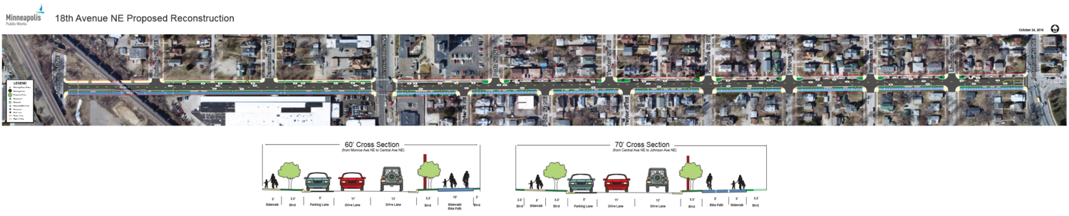
Cross section showing the area devoted to each mode of travel
Funding for the $5,910,000 project is a combination of MSA funds, net debt bonds, street assessments (against the adjacent property owners), lighting assessments, stormwater revenue and water revenue. The two biggest funding sources are MSA funds and net debt bonds.

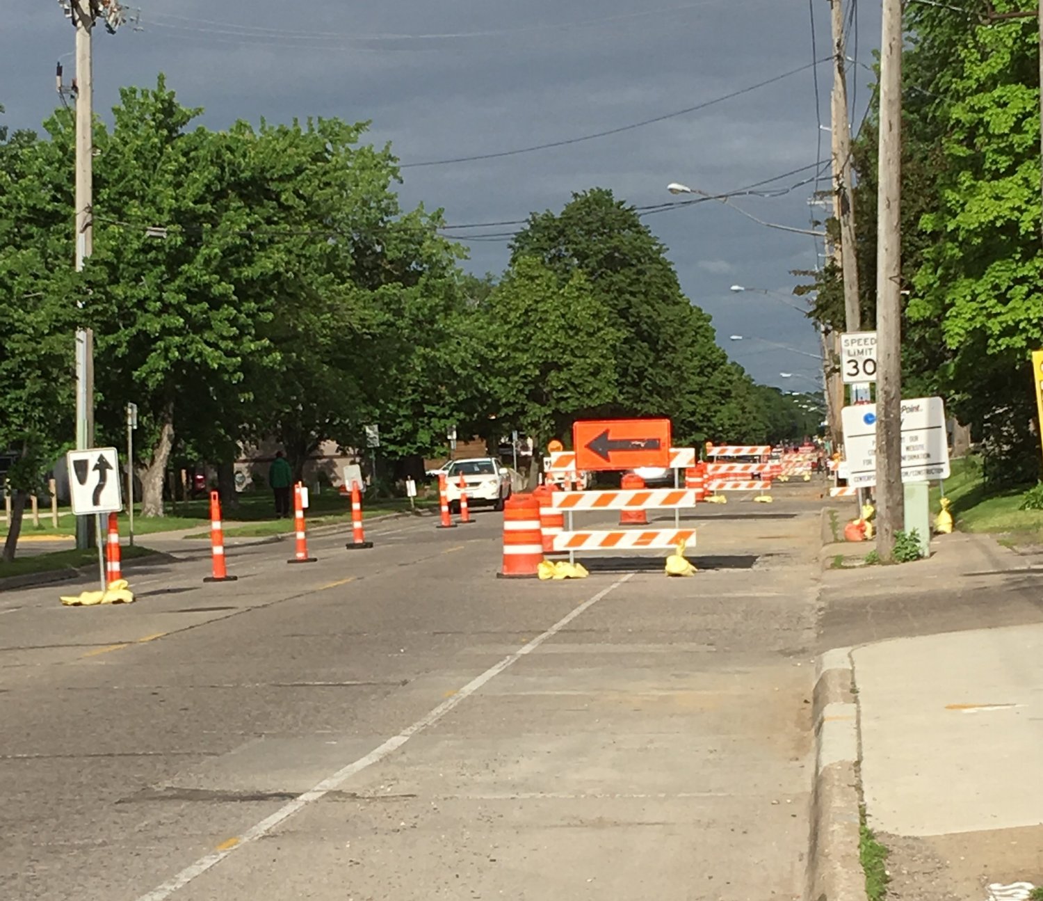
18th Avenue NE looking east from Central Avenue as construction begins
Construction is already underway for this street project and is estimated to take two construction seasons to complete. While it inconveniences residents that use this road daily, the result is greater than the hassle. The separated bike path is safer than the existing conditions requiring bikers to share the road, not delineated as a sharrow, with vehicles. It will encourage more bikers to use the path that otherwise would have avoided it because of safety concerns. Many residents living on 18th Avenue see this as a win for bicyclists and look forward to the new activity they hope to see in 2018. Thanks to Minneapolis’ new Complete Streets Policy, more streets are being built for the multi-modal travelers that use them.
Cross posted on www.theplanninglady.com (5/29/17)
I often struggle with doing something right vs accepting good enough. This is certainly an improvement over the existing street but is also far behind European standards and vastly more dangerous.
Here’s a link to the full-size plan: http://www.ci.minneapolis.mn.us/www/groups/public/@publicworks/documents/webcontent/wcmsp-188875.pdf
Two-way bikeways are quite dangerous because drivers do not look to their right. Then, as a bicycle rider going in the counter-flow direction you are uncomfortable and nervous at every junction because you don’t know if the driver sees you or not. How often will people want to ride if they’re constantly nervous and uncomfortable about being hit?
13′ driving lane? 11′ driving lane? These both send a message to drivers that it’s OK to drive fast and most dangerous that there is no need to pay close attention because you have lots of space to weave around in. No worry about who might be in the crossing ahead of you. These should be 9-10′ so that drivers are made to feel like they are unsafe and thus need to drive carefully and pay close attention.
Those are the two probable worst bits of this design. Others? How will signalized junctions be programed? Will they allow right-on-red? Will they provide fully protected crossings that don’t allow ANY cross traffic or will cars turning right or left create danger for kids walking? How much conflict will there be with a 10′ shared path in a dense urban area? How much conflict on the wider section if the bikeway and walkway are separated only by paint rather than grade separated? Who has right-of-way at all of the unsignalized junctions and how do people know? Will the ramps and curb cuts at each junction be jolting or smooth?
It appears they are continuing the walkway and bikeway across drives at the same color and grade which is good.
This design is about 30-40 years behind Dutch, Danish, and other countries. It is really a design for recreational bicycling not transportation bicycling. Do we celebrate that we will now be only 30-40 years behind instead of 60? That we’ll have a street that is only 7 times as dangerous as theirs instead of 15 times as dangerous? Is 7 times as many bicycle and pedestrian deaths good enough?
plus at some point the 2 way bikeway ends, and you’re on the wrong side of the street! Like at Stinson & Hennepin.
It kind of doesn’t matter if right on red is allowed, anyway – people are gonna turn like it’s allowed, no matter what.
But I do think we celebrate the incremental improvements. I am really cranky about lack of progress here until I try riding just about anywhere else we go.
Wait, weren’t neighbors concerned about parking??
What’s amazing about the 60′ cross section west of Central is that this is a design that has been used for decades on outer-ring suburbs’ collector streets — MUP on one side, sidewalk on the other. I don’t see those roads as all that bike or ped-friendly, but maybe they will be more effective with denser, more mixed land uses.
One detail that I would *really* like to see borrowed from Europe is to do tabled crossings across minor streets. This discourages cars from speeding through stop signs, makes crossings smoother for bikes and wheelchair users, and visually conveys that vehicles on the road are crossing a bike/ped space.
When the 7700 block of Harriet Ave was vacated in Richfield a couple of years ago, it was replaced with a private street and got a tabled “drieway apron” crossing of the sidewalk. I would love to see this design applied to public streets where they meet much busier roads as well.
They work and they don’t. Shoreview has this config (MUP on one side, sidewalk on the other) on just about all county roads. Here it’s far better than riding with 45-60 MPH traffic and does allow a lot of people to ride who’d not otherwise do so.
There are drawbacks though.
– Crowding. Sometimes the paths get extremely busy and it’s almost impossible to ride.
– Crossing busy roads. They’re great for those of us who live on the same side as the path, not so good for those on the other side. Even a two-lane Ramsey County road is difficult and dangerous to cross with cars going 45-60 MPH and not looking for people crossing nor expecting it. Marked crossings can be one to three miles apart.
– Two Way. Most of the Shoreview paths have few cross streets, though a lot of driveways, so drivers not looking to their right isn’t as much of an issue as it will be on 18th Ave. It’s still something you have to watch out for though. Most people who live in Shoreview do a good job but others not and this has caused some collisions.
– Ramsey County are doing ADA ‘upgrades’ to the paths which includes some bits that make them more dangerous for bicycle riders. For example, incorporating ADA walkway specs in to a multi-use path that has 2-3 times as many people riding bicycles as walking (yes, that will be a Beg Button Pedestal).
As far as the point about crossing busy roads, here’s my thinking: On a two way MUP when you enter it about half the time your destination is going to be on the other side of the road so you have to cross at some point. On a pair of one way cycletracks, about half the time you’ll need to cross the road initially because the cycletrack for the direction you want to go is on the other side. Then a quarter of the time cross the road a second time because your destination is on the same side of the road as you initially started on.
it is generally easier and safer to cross by going along the road, getting on the side of the lane you need to be on, and then turning across half the lanes of traffic than it is to cross perpendicularly. That gives a big advantage to one-way with-other-traffic lanes.
Yes. Good point. You’ve always got a bikeway on each side though so you’ve got some options for where you cross.
Here’s a good example in Shoreview: https://www.google.com/maps/@45.0948828,-93.1270472,100m/data=!3m1!1e3
Cunningham is the entrance to a housing development. Someone leaving their house and riding on Cunningham and wanting to go south on Hodgson has no place on their side of Hodgson (45 MPH posted, 50+ MPH average, 60+ MPH not unusual) to ride unless on the shoulder. They are pretty much forced to cross here and to wait until there’s a safe time to cross. If there was a one-way bikeway they could at least ride north to a safer place to cross. If it’s not very busy though they can ride contra-flow south to a safer place to cross.
While kids on the west side of Hodgson ride to school and to local eateries and stuff all the time, kids on the East side are told by their parents to not go near Hodgson.
Maybe the best option is to do MUPS on both sides then? If there actually is enough bicycle traffic that conflict with peds is an issue that would also disperse it. Some suburbs like to do MUPS on both sides, but it’s probably not possible given ROW constraints farther in.
Another general comment: why does Minneapolis seem to virtually never bury power lines as part of these projects? It looks ridiculous when they install expensive, beautiful post lighting, immediately underneath unattractive old telephone poles.
Richfield has buried lines on several recent projects, wrapping the expense into the project costs — 76th St, Portland Ave, and now 66th St. I believe many suburbs do this as part of road reconstruction. I get that it may not be worth it for every minor street, but it seems worth addressing for major streets.
Have to agree with this one. Also the boulevard trees Minneapolis plants eventually grow into the power lines and get pruned into unnatural shapes.
Bloomington it seems it’s half and half. I was talking to the Bloomington city engineer about the upcoming Old Cedar / Old Shakopee project and mentioned burying the power lines, and he confirmed that is a goal.
is the cost always on the city and not on the utility company?
Yes. If the city wants a powerline moved they always have to pay.
Once we all have solar roofs the power lines will go away anyway? 🙂
The bits of Blvd on the edges? Is that just unused right-of-way? Is the reason not to use it just to avoid encroaching in to people’s yards any more than necessary?
Yeah my guess is just because of grading issues, and because some of the houses are so close on the south side. See this front porch, which is probably just a foot or two behind the property line.
If it weren’t for that issue, it would have been nice to have wider boulevards, at least. That’s one thing I really miss about my hometown of Northfield — boulevards in older parts of the town are routinely 12 or 15′ wide. In most of the Cities, it seems like 6′ is typical. That’s still enough to grow a tree, but I do love the aesthetic of the bigger/grander boulevards when feasible.