The 21st Century Southdale Vehicle Collapse

The perception that traffic congestion is worse today than in the past is a real phenomenon. Might as well call it traffic nostalgia. Plus, the perception that traffic is only going to get worse is a common objection for constructing new housing anywhere. A fourplex or daycare being proposed can bring forth primal concerns about congestion.

We have seen real evidence that brick and mortar retail, as typified by the suburban mall, is facing competitive pressures from online shopping that has caused a trend of retailers closing across the country. In some cases entire malls have. Cities and the property owners have strong incentive to find new uses for the large amount of underutilized retail space. Because there is a shortage of housing, turning the space devoted to store cars into homes for people makes a lot of sense from the broad view.

Many neighbors of the shopping centers still object to redeveloping the empty stores and vacant retail parking lots to housing because of their fears about congestion. They don’t believe that traffic is truly reduced despite closing stores and windswept pavement. Among the objections to The Estelle towers along France was that the 152 units would overwhelm the Southdale area with empty nesters driving.

I’ve worked in the Southdale area since the early 1990s and I still do today. Because my workday begins at 9:30 in the morning and I leave for home at 6:30 pm I never witness congestion on the highways nor on the arterials. I had a nagging feeling that I remembered traffic a bit heavier in the Southdale area. So I decided to go digging into the MNDOT traffic counts. I downloaded the maps for every year from 2000 to 2016 (the most recent year available).

I was surprised by how much traffic has dropped. West 70th is down over 7,000 vehicles per day. France along Southdale was down nearly 8,000 vehicles per day. York is down over 6,000 vehicles per day. Here are the numbers.

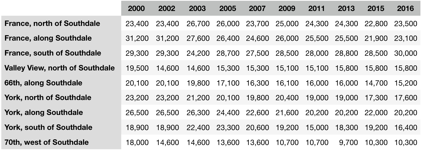
MNDOT traffic counts in the Southdale area 2000–2016

For those who work better visualizing numbers, here is a map of the area where I put in the chart for each section of street to see the trend lines.

Click map to large size.

Some notes: the Y-axis for the France Ave charts were set the same. The Y-axis for the York Ave charts were set the same. To make the trend clear in the charts I set the minimum and maximum Y values so the trend fit the space I had. Refer to the numbers above to get the percentage change.

The counts along 69th and 70th along Galleria between France and York have been stable for the past 15 years. Valley View between 66th and France was 11,000 in 2000 and is 8,900 in 2016. West 66th St east of York has also been pretty stable, but west of Valley View was 5,000 in 2000 but rose to 6,700 in 2016.

There is most certainly room to develop the Southdale area with the already approved residential proposals that have not yet finished plus a whole lot more based on the traffic trends alone. Concerns about worse “traffic” from new apartments and condos surrounding Southdale won’t come close to the traffic that the recent past experienced.

Eric Anondson

About Eric Anondson

Born in St. Louis Park and lived there nearly 28 years but has been living in Hopkins since 2008. Eric's hopped around two years or so at a time in Loring Park, Laurel Village, Snellby, Whittier, and Golden Valley. He works in downtown Minneapolis. On Twitter as @xeoth.

19 thoughts on “The 21st Century Southdale Vehicle Collapse

  1. Adam MillerAdam Miller

    Someone (not me, someone who is technologically competent) needs to do this for other areas people think have gotten worse. Uptown being the obvious one that comes to mind. Where else?

  2. Eric AnondsonEric Anondson

    Also worth noting that W 70th had a 4–3 road diet a while back. Drivers adapted. No apocalypse.

  3. Cobo R

    Any speculation for the decrease in traffic?.. Any major business move or shrink?

    I don’t frequent the southdale area enough to be aware of any trends or changes.

    1. Monte Castleman

      I don’t think it’s any more complicated than “people don’t shop at Southdale anymore”.

      1. GlowBoy

        The decline in mall retail – and retail, generally – may be the biggest reason, but in fairness across the street the Galleria seems to be slammed with shoppers and diners at all hours, all days.

    2. Eric AnondsonEric Anondson

      There have been a slow drip of retail closings. I’ve read some analysts point out that the US has an oversupply of retail square footage. There is also the online shopping phenomenon.

      But with The Galleria sucking up the upscale luxury shopping customers and MOA nearby drawing in the mass mid market shoppers … ¯\_(ツ)_/¯

      Southdale’s owners are filling in their empty outlots with apartments (a couple years old now), and the coming Shake Shack, a hotel, and a RH Gallery concept store. But the main building still is fighting vacancies.

      1. Monte Castleman

        Even the MOA realizes that mall shopping is on the decline. The grandiose 2nd phase has been vaporware for the past 30 years, instead we got a much more limited expansion focused on trying to get an cap over Lindau Lane and lure some specific luxury retailers. The owners newer concepts tend to be only 50% retail and the proposed city owned waterpark is to try to move the MOA in that direction. The current proposal is much more grandiose than previous plans, along the lines of the one in West Edmonton that’s a major tourist draw, not the previous concept of a small corner adjacent too a hotel.

        1. Eric AnondsonEric Anondson

          I think that’s right. MOA probably has advantages at being able to add regional experience attractions. I could see far more and bigger hotels. A lot of tourists coming to the Twin Cities would appreciate being next to a huge center of a wide variety of things. I think the Super Bowl showed people visiting for some big experience kinda want to stay near the a center of energy and like it or not MOA has a lot there that many like. More hotels, more tourist experiences, and there is still room for abundant spontaneous shopping.

          Southdale, we can argue what an ideal future would be, IMO the area would best be served by a return to the original concept of a old town center of mixed uses. Being within the political borders of Edina voters may be the biggest challenge to finding new uses for all the underused land surrounding Southdale. Edina’s tax base has increased by a lot just by the tear down wave. Arguing that filling vacant parking lots with middle class is just going to scare long time Edina residents that the schools will be threatened because the city doesn’t “need” the money from that development. It gets enough from destroying expensive homes and making even more expensive homes.

  4. Walker AngellWalker Angell

    Awesome charts!

    Something to think about… People visiting retail will always be driving to/from the retail establishments = lots of car trips.

    If the area is designed properly and is safe for walking and bicycling then people who live there can often walk or bike and avoid a car trip. Even better if they can walk/bike to work somewhere locally (assuming they are not retired or don’t work from home). Would someone who lives there be more likely to take transit to work than someone who is coming to shop?

  5. Bill LindekeBill Lindeke

    This reminds me of when Mpls Planning Commissioner Magrino stated that traffic on certain roads was dropping during a meeting and was booed by the audience.

  6. Stu

    Judging from Edina message boards, the fear of “additional traffic” is very very real as it relates to property value.

    My observations from a distance (I live in Minneapolis) is that the same cadre of people target ANY development project in Edina for one reason. Property values.

    According to this cadre of Edina residents, property values can be damaged by really any change at all. Perceived traffic increases, the addition of sidewalks, coordinated garbage pick up, luxury apartment garage doors, school curricula changes and anything… anything at all that could be considered “density.” 2 story abandoned buildings in mild disrepair are preferred over 4 story apartment buildings. The removal of some trees near the Southdale sign for the construction of the Shake Shack even elicited a “property values” comment.

    Lots of “when I moved here 2 years ago it was for high property values and low taxes. Now we are letting just anyone move here, which will add kids to the schools! That will raise my taxes and damage the reputation (it is always assumed that “those kids” are of lower quality than “my kids”) of the schools and lower my property value!”

    The Estelle never stood a chance. It was tall, which means it was super maximum ultimate “dense” and I believe it was on the Edina side of the Richfield/Edina school district border. Lest those downsizing baby boomers and their school age kids cause school overcrowding.

    1. Sean Hayford OlearySean Hayford Oleary

      What’s really funny about Estelle is that it wasn’t technically very dense at all. It was very tall. I believe du / acre (so, households per acre) was around 60 — which is reasonably high-density, but a level you can easily hit with a 4-story apartment building. It was a very slender tower on a good-sized site, and had large average unit size. Nearby, Aria (formerly known as “Envi Edina”, formerly known as “CAKE Residences”) is over 90 du/acre, despite being only 5 stories.

      Have not personally heard property values as a major concern, only general “livability” concerns. Traffic is a major one people cite. See for example this Twitter exchange between me and a few Edina residents.

  7. Aaron IsaacsAaron Isaacs

    The thing to remember about NIMBYs is that you can’t change their minds. If you demolish all their arguments with logic and facts, they simply raise new ones. The trick is to convince the city officials who make the decisions, officials who are all too familiar with and tired of NIMBYs.

    1. Eric AnondsonEric Anondson Post author

      I saw this about a year ago when I posted MNDOTs oldest counts and also most current counts to a comment section in the Strib. Numerous Edina commenters doubted the MNDOT counts and said their memories were a more acucurate truth about traffic. Literal traffic nostalgia.

      I wanted to go get all the traffic counts and chart the entire trend for this post and I think it tells a compelling story about our need to prepare our large amounts of land devoted to only retail and storing cars for the declining shopper.

    1. Eric AnondsonEric Anondson

      Thanks!

      I think another worthwhile analysis to look back at is compare recent street and bridge work and see where volumes dipped or shifted or whether detours from highway work shows up in these street counts.

      1. Adam FroehligAdam Froehlig

        In this case, and from what I recall, probably not a factor along France, but definitely a factor with York to the south and with 66th.

        Another thing to note is your point charts are not completely accurate temporally…note that some of the published volumes are only one year apart instead of two years. Your chart scale does not reflect that.

        1. Eric AnondsonEric Anondson

          Fair point on the X-axis. MNDOT didn’t have 2017 nor 2001 maps. 2016 was the most recent.
          County road counts and city street counts looks like were done every other year with county and city alternating year, city one year then county the next year.

Comments are closed.