
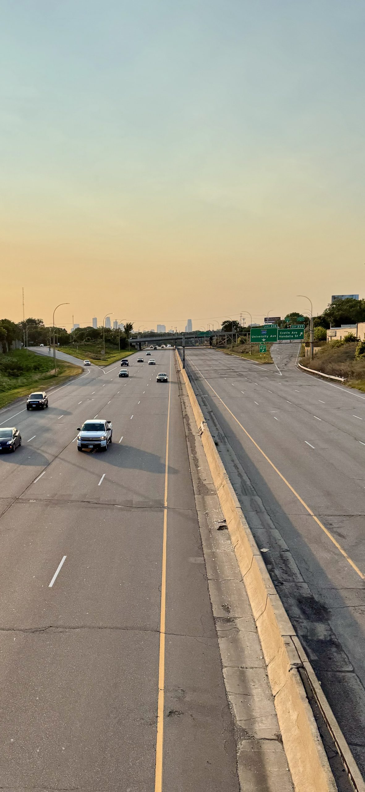
From Friday, September 6 to Monday, September 9, I-94 between Interstate 35E and State Highway 280 was closed to westbound traffic, providing a rare glimpse of what the stretch of freeway in St. Paul would be like without cars.
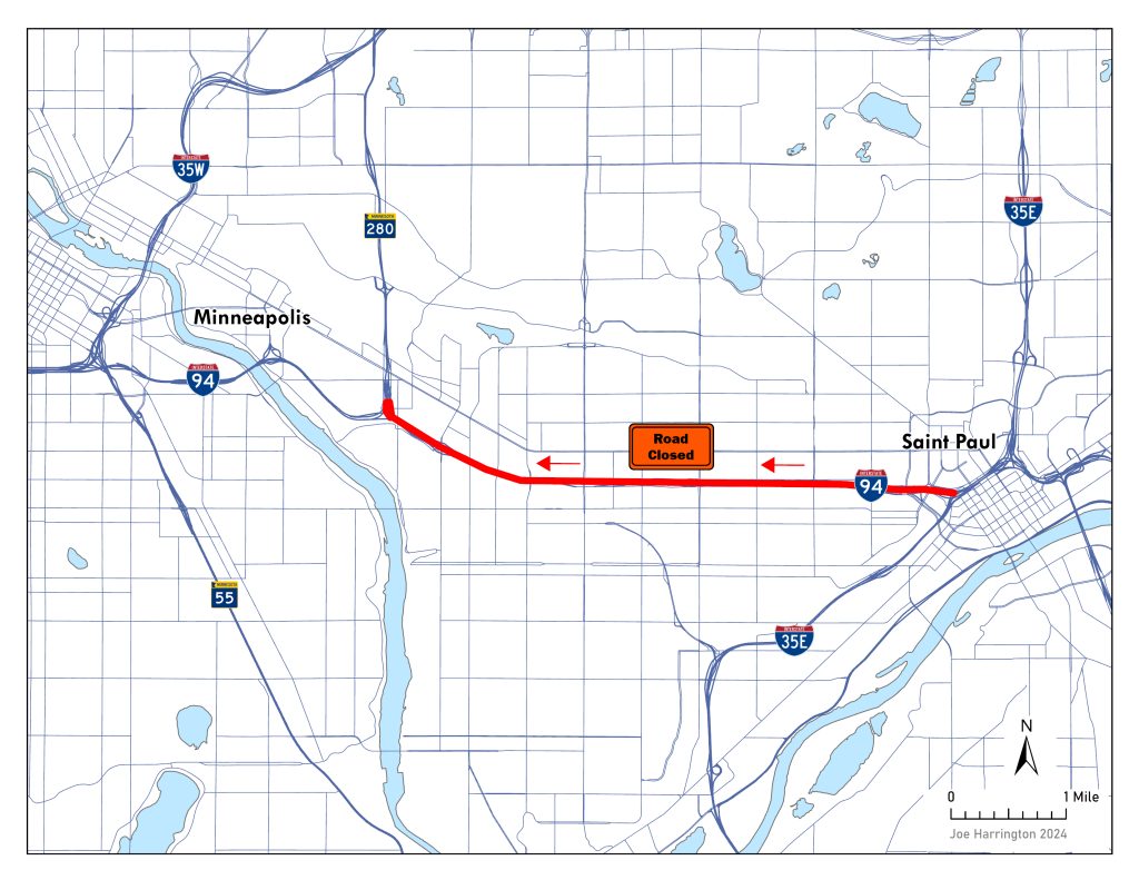
The closure was part of regular maintenance work on the highway, an occurrence that will likely become more common as the highway infrastructure deteriorates and the corridor reaches the end of its useful life.
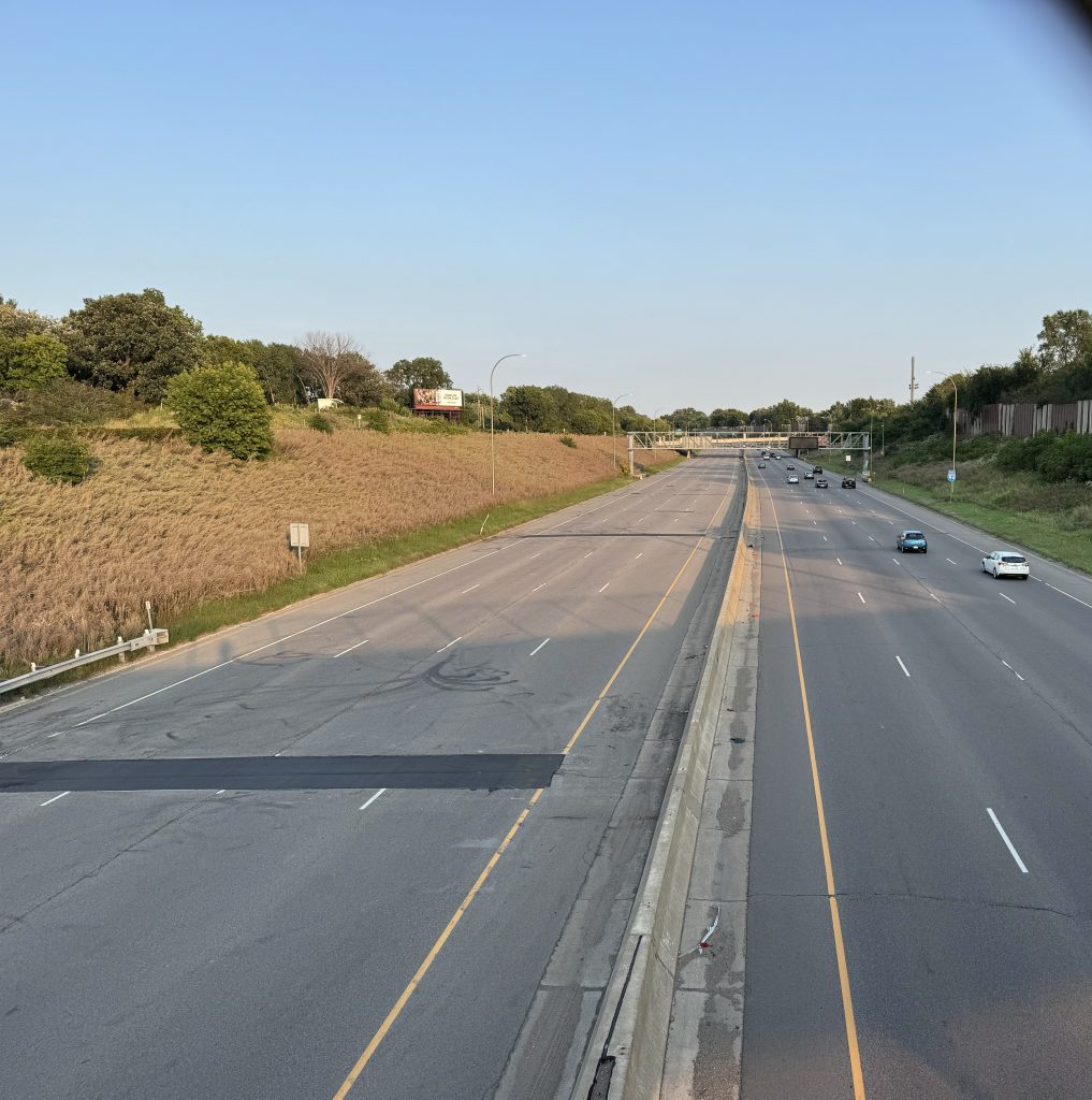
For me, like most of us who never saw the Twin Cities before they were carved up by highways, the sight was almost dystopian. Walking around near the half-abandoned freeway felt unfamiliar as the roadway — normally choked with traffic and plagued by the sound of cars and trucks wheezing by — lay mostly silent.
This “pilot” of a car-free I-94 comes as MnDOT continues to weigh options for the Rethinking I-94 project, meant to decide the future of the highway and communities who live along it. The project’s current phase, referred to as the scoping period, seeks to narrow down alternatives from the existing slate of proposals that range from removing the highway and replacing it with a boulevard to expanding it altogether.
The highway closure this weekend encourages Twin Cities residents to look beyond the highway and explore alternative transportation methods and routes, potentially reshaping their travel habits and perspectives on urban mobility. Westbound travelers had to adapt, using alternate routes, different transport modes, adjusting schedules, or modifying plans, while eastbound traffic remained unaffected.
While MnDOT did not measure how the closure impacted the way Minnesotans moved along the corridor or around the broader region over the weekend, other studies suggest how people adapt to these changes.
How Is I-94 Used Today?
Analysis of transportation data along the I-94 corridor shows that most trips are short, averaging less than 5 miles, with 25% under 2 miles. Surprisingly, 61% of these trips are for non-commute purposes like retail, dining and social activities, while only 39% are work or school commutes. Moreover, a mere 5% of trips through the corridor are “through trips” with no local origin or destination, challenging assumptions about the highway’s primary use.
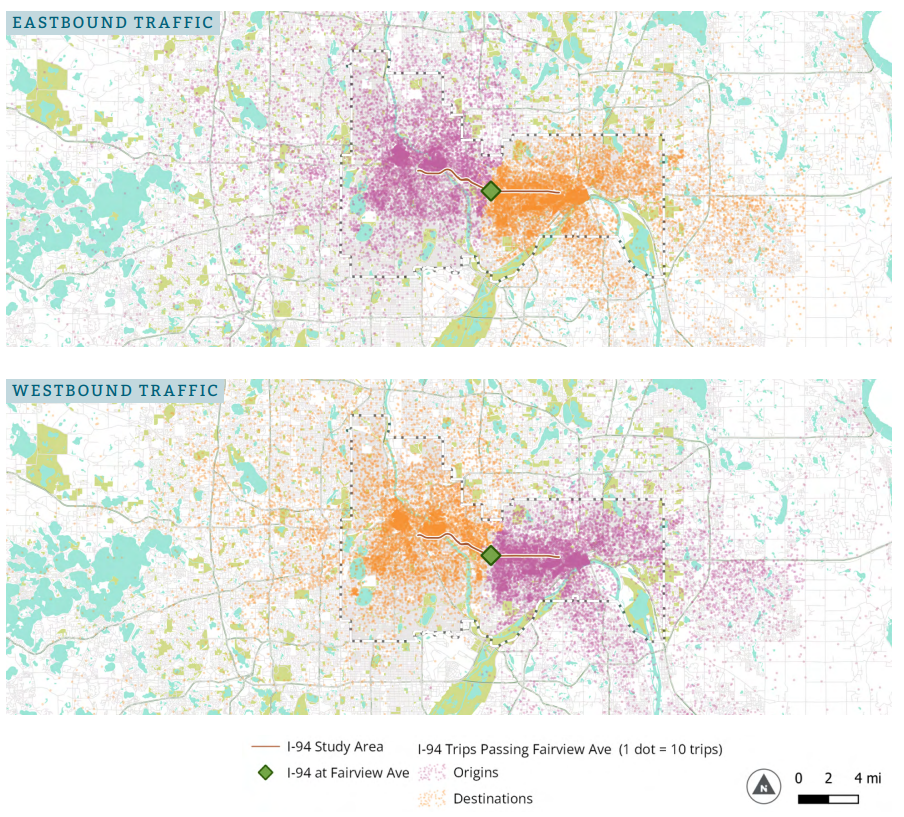
The maps above emphasize these trends, with eastbound and westbound destinations and origins largely clustered in Minneapolis and St. Paul with a significantly lower share of suburban commuters using the roadway. These local trips, as shown by this weekend’s closure, can more easily be substituted for local roads or other routes.
The I-94 trench also creates a north-south divide in the Twin Cities, disrupting local traffic flow and safety. It causes congestion at key points and poses significant barriers for pedestrians and cyclists, with limited and often unsafe crossing options. The highway creates a mental and physical barrier in once-connected neighborhoods and communities.
COVID-19 and the changes to the way we move around the city have also impacted current travel behavior. According to data from Replica, traffic on I-94 in the study area peaked in 2004-2008, dropped significantly during the pandemic, and has since recovered to 2019 levels. However, current travel patterns show more evenly distributed non-work trips throughout the day.
Together, these findings contradict MnDOT’s messaging and common public beliefs about the highway’s usage. The data suggest that an interstate highway isn’t the most effective infrastructure for these predominantly local, short-distance trips. Instead, a reconnected street grid and a boulevard could adequately handle the current volume and types of trips through the cities.
What Happened During This Highway Closure
At least anecdotally, highway travel remained relatively unaffected. Because the region has many other highway routes, travelers could substitute their normal drive along I-94 for a variety of other routes.
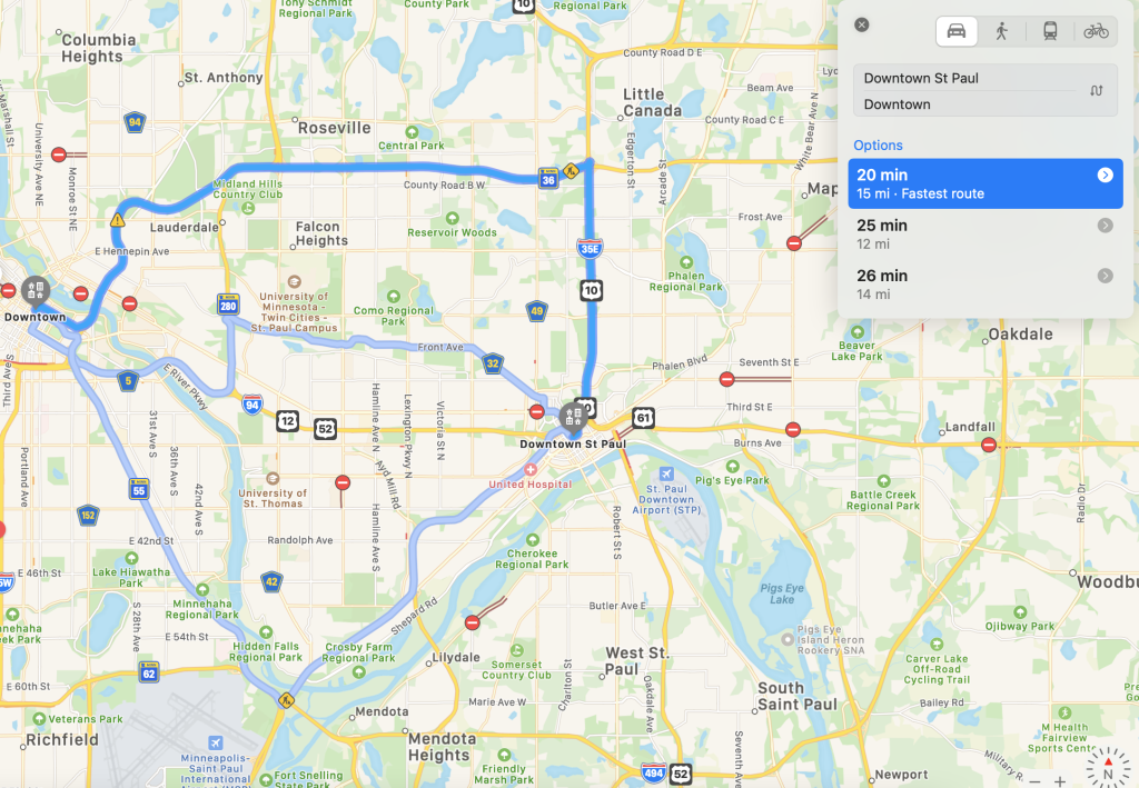
For example, a commuter between downtown St. Paul and downtown Minneapolis could still move between the downtowns quickly, swapping the drive west on I-94 for MN 36, Ramsey County Road 32, and MN 55 to I-35E, all under 30 minutes.
Suburban commuters also had a variety of choices on Sunday to move around the Twin Cities. Travel time from Woodbury to Downtown Minneapolis also had several substitutions including MN 62 (the Crosstown) and I-35W, I-94 to I-35E and MN 36, and MN 62 to MN 55.
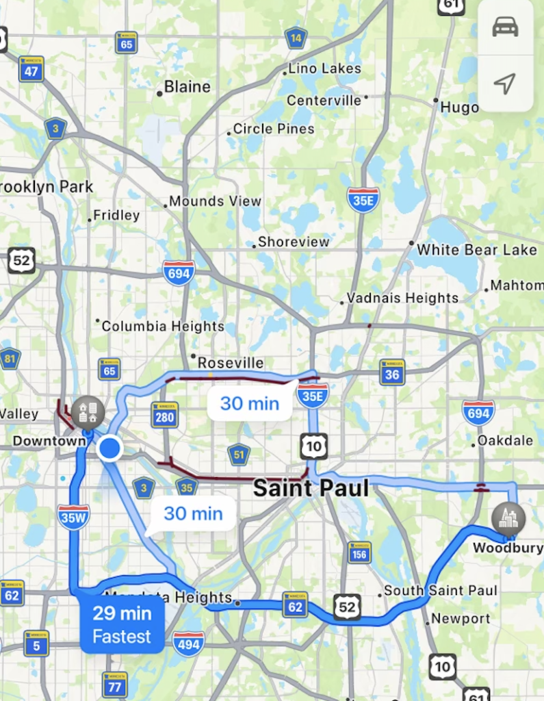
Of course, this is just anecdotal and doesn’t reflect what travel times would be like during peak commuting hours. However, this does prove that even as a major corridor is not active, travel around the region is still just as viable on other routes.
How Might People Adapt to a Long-Term Highway Closure?
Given how Minnesotans use the highway today and the brief nature of this weekend’s closure, it’s hard to glean insights on how removing westbound travel changed mobility in St. Paul over the weekend.
Despite this, we know what might happen if I-94 was removed and replaced with a boulevard based on a natural experiment during the 2007 I-35W bridge collapse, showing how highway closures affect travel behavior.
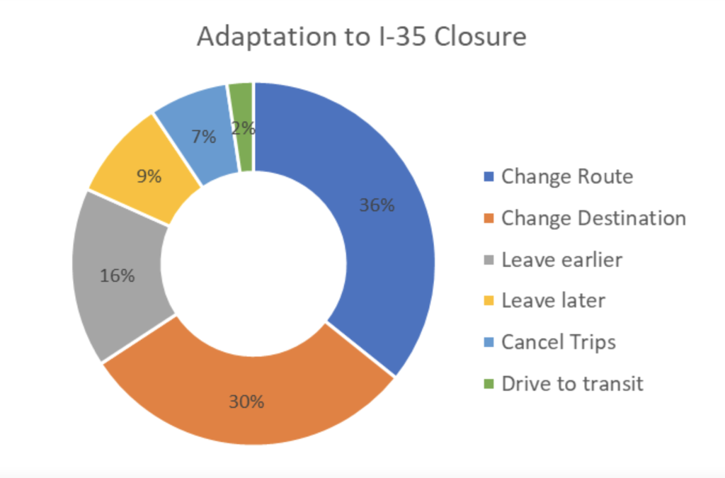
A MnDOT report found that many commuters could easily substitute parts of their trip for other routes. Others changed their destinations, or travel times, or did not take trips at all. In some cases, even without short-term public transit investments, some substituted their car trips for transit.
The regional impact diminished with distance from the bridge, as more alternative routes became available. The bottom line: the region kept moving without the highway.
While this disruption was unplanned and not permanent, MnDOT’s conclusion supports this idea. In the report’s words: “In contrast [to an unplanned disruption], a preplanned disruption, even with similar magnitude, generates much smaller impacts.” This is largely because residents have time to make adjustments to their travel patterns.
On a more fundamental level, this phenomenon points to induced demand and traffic evaporation, two sides of the same coin in traffic planning. In essence, you get what you build, meaning if you build more infrastructure for cars like highways or parking, more people will choose to drive because it’s made easier to do so. The flip side is also true, where if a highway or other car-oriented infrastructure is removed, traffic goes with it as people make different transportation choices to adapt to the change.
In the case of MnDOT’s recent closure, it wasn’t long enough to get beyond an anecdotal assessment of how it changed westbound travel through the Twin Cities, especially as it spanned a weekend and did not impact commuting. However, the I-35W bridge collapse provides us with a long-term glimpse of how the corridor’s drastic change impacted people’s travel choices over a year.
While I-94 reopened before the Monday morning commute, this weekend’s closure could be seen as a pilot for a future beyond a highway. The roadway — which MnDO0T often refers to as the state’s most significant — was 50% closed over several days without major regional distribution, gridlock throughout the cities, or more than a minor inconvenience. Next time such a closure happens, it would be exciting to see MnDOT open the highway to bike or walk even for a short time – or at least – measure the changes in how people travel around the region differently during it.
As someone who has spent a lot of time thinking about what the cities would be like without I-94 and other highways, I found it nice to experience how that might be, even if only for a day or two.