
I’ve got highways on my mind this week after MnDOT moved to remove the “at-grade” boulevard options from consideration in the Rethinking I-94 process at a project meeting on Friday, January 17. As Streets.mn already has reported, very little “rethinking” has gone into this process.
But, while some may be shocked at the idea of removing a freeway and question where all of those fast-moving cars and trucks will go, it’s important to consider how much of a rethinking of cities it was to build urban freeways such as I-94 in the first place.
Today, as we reckon with the ways infrastructures have reshaped our communities, we must also consider the sheer scale of the land that highways displaced and who lived and worked there.
The Twin Cities, much like other U.S. cities, were carved up between the 1940s and 1980s for the construction of the interstate highway system. Following the passage of the Federal Aid Highway Act of 1956, highways and car-centric planning logic was cemented as a core tenant of American cities.
While this impacted all cities, the miles of new interstate and the land it replaced had vastly different impacts on different types of communities.
This displacement continues a long history of land dispossession in Minnesota. There were the broken promises to the Dakota in 1851 and the racially motivated construction of Olson Memorial Highway in the 1940s, which became Minnesota’s first blueprint for highway-driven displacement. It’s part of a broader pattern — including racial covenants, redlining and other practices — that has created inequitable urban spaces.

This blueprint was scaled up in the 1960s as major highways like I-94, I-35E and I-35W divided and displaced communities in Minneapolis and St. Paul. These projects, championed as symbols of progress and urban renewal, would shape Minnesota’s cultural and physical landscape for generations to come.
Throughout the Twin Cities metro, nearly 50 square miles of land was converted from a variety of land uses to highway infrastructures. That’s roughly equivalent to the land area of the City of Minneapolis.
Missing from this assessment is the answer to a simple question: How was this burden unequally distributed among communities?
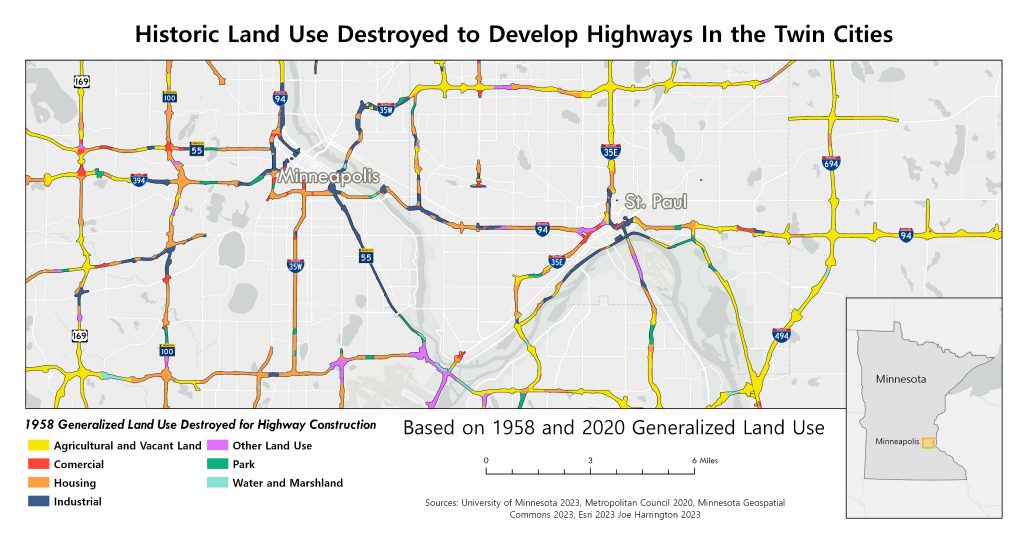
How Highway Construction Reshaped the Twin Cities
In the core of the region, Minneapolis and St. Paul lost 4.14 square miles of land to highway construction between the 1950s and 1980s, roughly 3.6% of the two cities’ combined land area. Housing, comprising a mix of single and multi-family homes and apartments, and industrial space were the most impacted. This land-use change took productive land that was serving the community and generating revenue for the local tax base and turned it into a costly infrastructure liability that has taken an immense amount of capital to build and maintain.
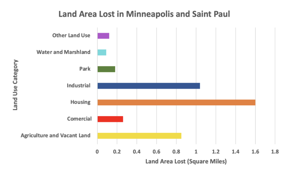
Beyond the economic impact, this process stripped the Twin Cities of many spaces of collective life, reshaping relationships with the city and its people. Countless restaurants and bars where people could connect and relax were torn down. Places of worship where people gathered to celebrate and mourn were destroyed or relocated. Urban amenities like grocery stores and healthcare facilities had to close their doors. Even the everyday joys, like running into your neighbors on the sidewalk or in a park, were changed, altering the social landscape of the Twin Cities. Today, highways still occupy these spaces.
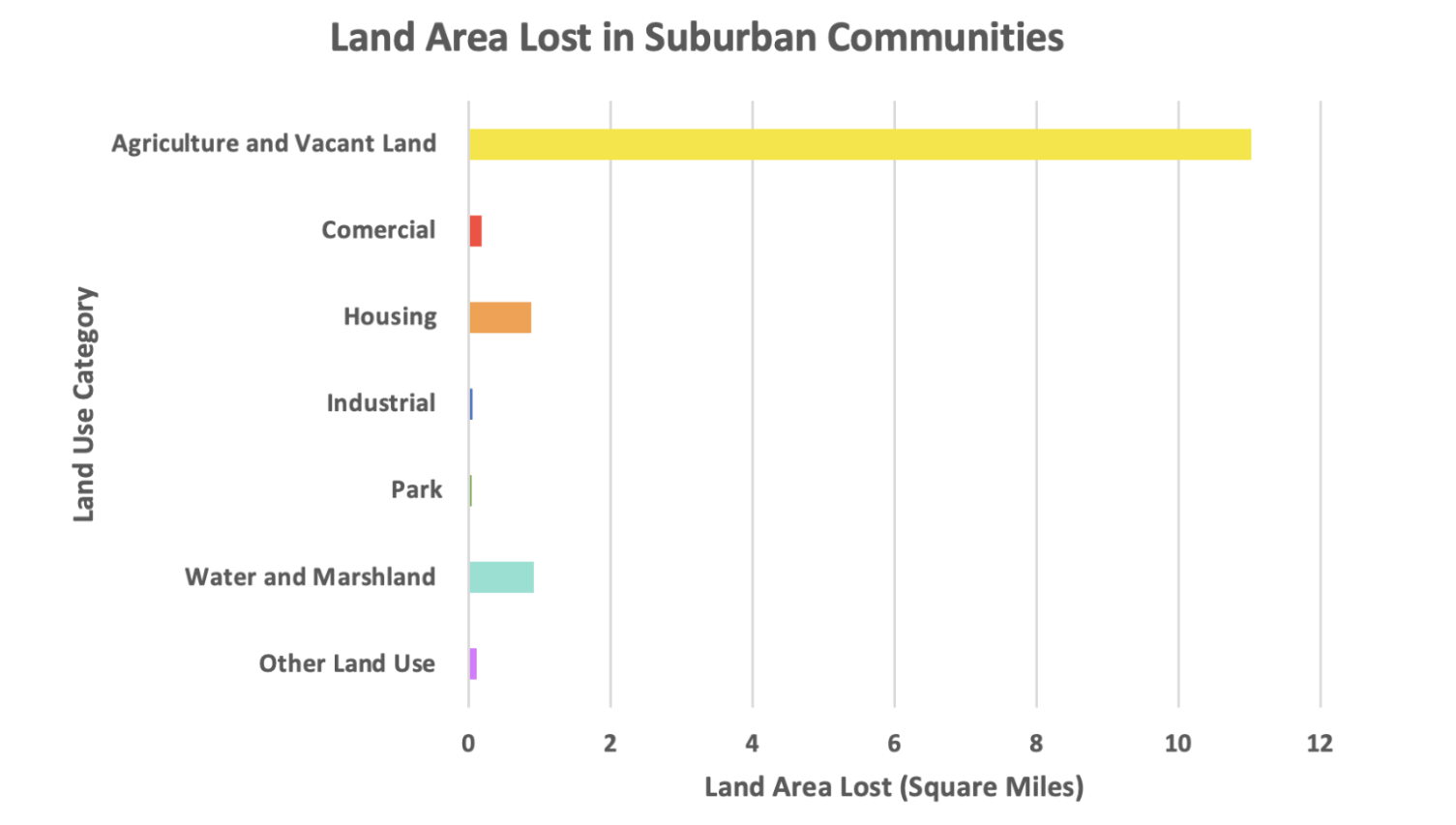
In suburban communities, highway construction painted a very different picture. Agricultural and vacant land was the largest affected land use category, by far. In 11 fast-growing suburban areas, including Bloomington, Edina, Brooklyn Park, Plymouth and other suburbs, highways consumed 13.23 square miles of land in the decades of highway construction. Of this, 84% (11.02 square miles) was vacant or agricultural land.
Water or marshlands and housing were the second and third most affected areas, respectively, but just under a square mile was lost each. In total, these suburban communities lost 4.3% of their total land area.
Suburban expansion and car-centric infrastructure prioritized high-speed suburb-to-downtown travel, while racial and class biases drove urban disinvestment and so-called renewal projects.
However, unlike urban areas, suburban highway construction mostly used vacant or agricultural land, causing less displacement and disruption. Communities could be intentionally designed to preserve or create collective spaces for daily life and to largely avoid hits to the tax base from displacement.

Where Were Harms Concentrated?
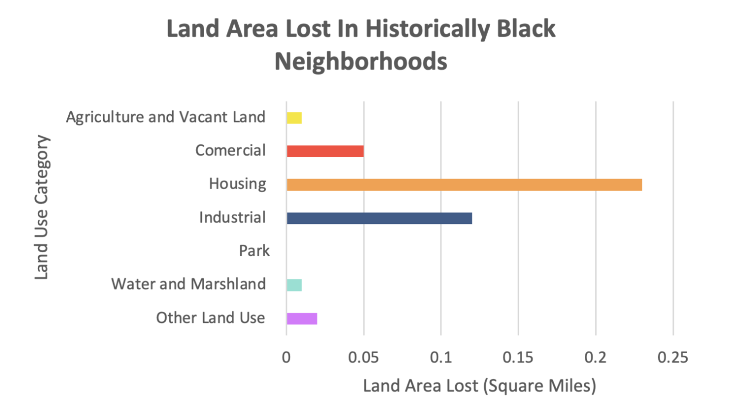
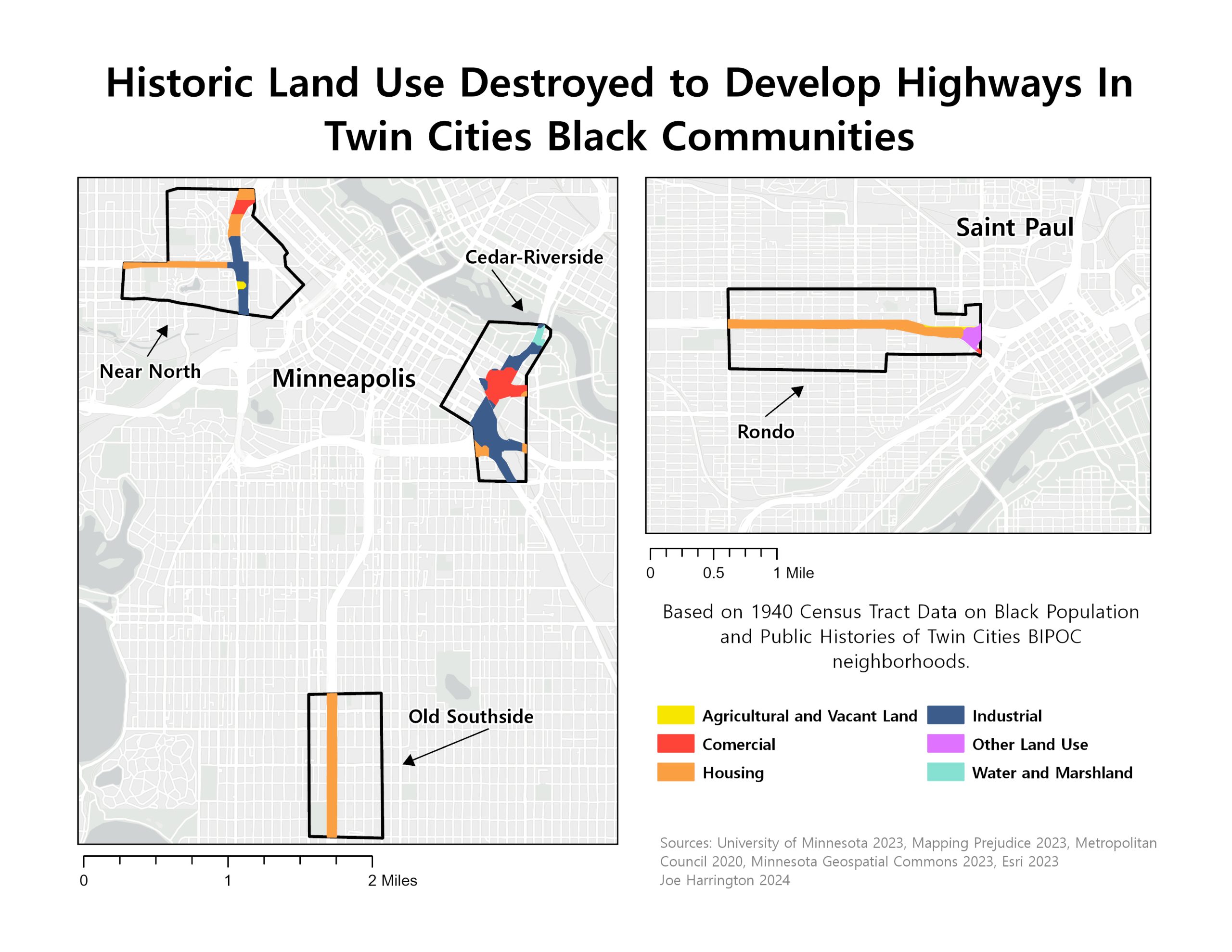
Black communities in the Twin Cities lost the most, both in terms of land area and the role the land played in communities’ sense of place and prosperity. Based on public history records and U.S. Census data from 1940, the Twin Cities’ Black neighborhoods were concentrated in Near North, Cedar-Riverside and Old Southside in Minneapolis and Rondo in St. Paul. These communities accounted for 2.82 square miles, roughly 2.3% of Minneapolis and St. Paul’s combined land area.
Highway construction razed 15.6% of the land in these four communities, disproportionately high compared with other areas. Housing, industrial and commercial land comprised the majority of these losses, stripping communities of homes, jobs, businesses and community spaces. What was left was divided and disrupted, changing the social landscape of these communities.
Unlike the experience of white residents displaced by highway construction, Black residents were prevented from moving freely to other areas of the cities or suburbs due to tactics such as racial covenants, violence and intimidation. This siloed people of color into neighborhoods along highway corridors at a disproportionately high rate.
Today, generations of residents have been left to face health, environmental and other ongoing harms from the highways bisecting their neighborhoods.
Highway planners and government officials cemented for generations the way we use urban space and access employment, goods and services. In the process they created a contested allocation of urban space, raising the question: Who are highways (and the spaces they displaced) for?
While promoted as community assets, highways instead burden low-income areas often dominated by people of color with environmental, health and economic costs. These communities, often with lower car ownership, use highways less but suffer more. As a result, cities lost valuable land and tax revenue to state and federal roadways, mirroring nationwide patterns where highway construction bulldozed billions in wealth for minority communities and millions in potential tax income.
A Roadmap for a Better Future?
As we reimagine urban spaces, we should focus on communities that have endured historic and ongoing harm from highways, while recognizing those who have benefited most. We also should prioritize the tax bases of our cities and productive land uses like housing and commercial space that make our cities economically and socially rich.
The built environment and policies that shape communities reflect our values. It’s time to bring back spaces of collective life, places to live, work, build wealth and relax — opportunities all taken from Black and immigrant communities and others living in the path of highways. In highway planning and policy, these factors are often left out in the way we assess potential costs and benefits of potential changes to a corridor.
Rather than close the door on proposals that reclaim and repurpose highway land, our cities, states and people must empower these residents to shape community-preferred alternatives, implementing their vision to create more inclusive and vibrant urban spaces for our city today.
Editor’s note: “Street Views” appears in Streets.mn twice monthly. Respond to columnist and board member Joe Harrington directly at [email protected]. You may also add comments at our Streets.mn pages on Bluesky and Facebook.