

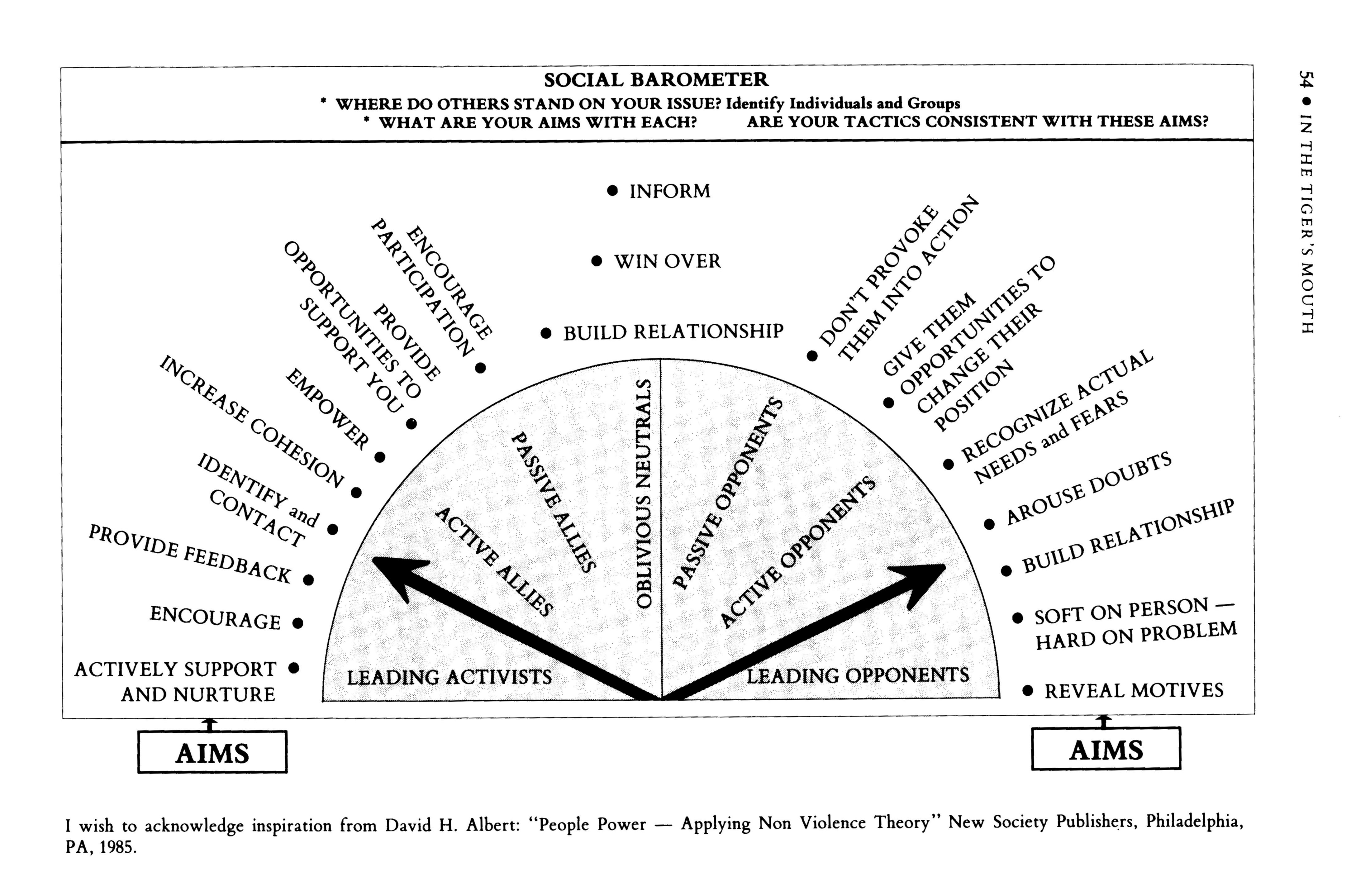
Concept B to improve Sibley Triangle for public use and pedestrian realm. Concept A “unimproves” the current site, replacing a fossil fuel maintenance scheme with natural plantings and stormwater retention. Minneapolis Park and Recreation Board.
[dropcap]S[/dropcap]ometimes people ask if I am bummed to not win last year’s Minneapolis Park & Rec Board race and my answer is always a resounding No. Five seats flipped and my Big Ideas won, along with a new majority ready to implement the same goals. A personal favorite, the Triangle Improvement Plan, was fully and faithfully represented in the first draft of this year’s East of the River Service Area master plan¹ (comment is open now).
As a ridiculous extrovert² I loved campaigning. The best part was constantly speaking with neighbors IRL about their hopes and dreams for building a better city that works for everyone. This genuine, person-to-person exchange of histories and ideas grows enthusiasm and understanding in both candidate and supporter. The worst part was constantly conveying the same Online while attempting to demonstrate a bigger vision in a bad faith environment full of false narratives forwarded by the former régime. Nuance around big ideas becomes “You’re actively working to undo the last 40 years of progress, full stop.”

Looking west across Nicollet Island toward Minneapolis in 1900, the year DeLaSalle opened as a Christian Brothers commercial school. Note the long contiguous warehouse block on the right. MNHS via @billlindeke and Stuff About Mpls.
This same unreasonable hive-mindset later moved onto Minneapolis 2040, and the resulting outrage moved me into researching and tweeting about parks again. Surprisingly, my riff off of Bill Lindeke‘s twete about Nicollet Island gained traction. I later linked it to my campaign’s previously secret 2080 Plan for a densely populated, car-free paradise on the north half of Nicollet Island. To my additional surprise, a City Pages reporter asked for an interview and the ensuing article correctly captured the bones of the concept:
“These 600-square-foot houses are worth $1 million,” he says. And the people who live there feel comfortable to stick out their 99-year leases. https://t.co/ynQvQG21R4
— William Lindeke (@BillLindeke) September 13, 2018
The second sentence refers to a specific conversation with an island resident known for her flowery language. At last year’s Pollinator Party I asked Phyllis about her house and she said, “My kids will get it. What will happen to this place when the leases are up? I don’t care, I’m gonna be dead!” We laughed together, her guffawing and me chuckling nervously. The express purpose of my Park Board campaign was to dismantle this sort of IDGAF attitude of rugged individuality over the power of collective action sold to us by the Ponzi scheme of Global Capital. BREAKING NEWS: We can’t buy ourselves out of an extinction level event!!

“Old Men Standing Outside Nicollet Island Grocery.” Hennepin County Library.
[dropcap]W[/dropcap]e need a Neoliberal-Free Minneapolis that prioritizes public benefit over private profit.³ We need visionary public investments in order to handle the inevitable influx of climate refugees in this century while also working to sustainably survive into the next one. The solutions can be simple or complex, applied at a small, large, and/or universal scale. The Triangle Improvement Plan is a small and simple concept that can be repeated universally as Capital Improvement Dollars reach the furthest corners of our enormous park system. Nicollet Island, by contrast, offers the opposite opportunity: the single inhabited island along the 2,320-mile Mississippi River, nestled right between the original Twin Cities of Minneapolis and St. Anthony. We’ve successfully spent the last forty years opening up space along the riverfront through de-industrialization. Now it’s time to spend the next forty bringing the people back.
The history of Nicollet Island is the history of Minneapolis, from colonization and industrialization to decline and rebirth. At 45 acres it is the size of Stevens Square, or about 85% of Île de la Cité, the medieval heart of Paris. The changes† in its built environment – good and bad – reflect the gamut of the Big Ideas foisted upon our landscapes over the generations to “solve” various urban social ills. The island’s current iteration of “restoration” took shape in the 1970s and was set in amber on May 19th, 1983 by determined residents (some of whom happened to be state legislators), City, State, Met Council, and Park Board staff, and then-Mayor Don Fraser. I will examine the ideas that led to this agreement and the other contested landscapes Nicollet Island provides. This comparison over time will demonstrate the unique role this public land can offer for humanity’s moral imperative to ensure the survival of Life on Earth. As Utah Phillips was fond to say, “The long memory is the most radical idea in America.”
Mississippi/Minneapolis
Historians believe that the indigenous Dakota Indians may have tapped its sugar maples for syrup production before settlers converted the island into farmland during the mid-1800’s. From 1876 to the 1970’s, the island was a prominent industrial site, dependent on St. Anthony Falls’ water power to run industries from foundries to sash and door manufacturers. The houses at the island’s north end were built during the 1860’s and 1890’s for upper-middle-class industrial managers, then became a hippie community in the 1970’s, before being restored during the last decade.” — 1995 New York Times article about MSP’s islands.

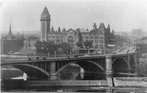
Third (1891) Hennepin Avenue Bridge meets Nicollet Island in the 1960s. View from Minneapolis Post Office across to St. Anthony, facing northeast. Every single building in this photo will be gone by 1974 with one notable exception: Island Sash & Door Co. Hennepin County Library.
[dropcap]T[/dropcap]he first European-Americans to fully capitalize on Nicollet Island’s status as private property were John Merriam and William Eastman, whose investor group purchased the whole thing from Franklin Steele in 1865. They intended to profit from previously ignored “water rights,” and the resulting chicanery of the Eastman Tunnel nearly completely destroyed St. Anthony Falls in 1869! Merriam and Eastman still developed their master-planned sawmill community throughout the latter 19th century, the era of Haussmann’s renovation of Paris. You can see this reflected in several of the island’s historic mansard roofs. At the turn of the twentieth century, North America’s parallel urban renewal movement took hold. City Beautiful inspired the end of the unwashed, unruly nineteenth century city, and its ideas were the first to move the Mississippi River from power source to prominent feature for human gaze in the Minneapolis landscape.
Make no little plans; they have no magic to stir men’s blood and probably themselves will not be realized. Make big plans; aim high in hope and work, remembering that a noble, logical diagram once recorded will never die, but long after we are gone will be a living thing, asserting itself with ever- growing insistency. Remember that our sons and grandsons are going to do things that would stagger us. Let your watchword be order and your beacon beauty.” — attributed to Daniel Burnham, 1910

The first Bridge Square at the junction of Nicollet (L) and Hennepin (R) Avenues, 1867. The second Bridge Square made great use of mansard roofs. MNHS.

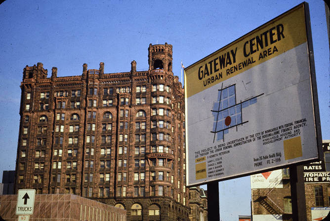
The first Gateway from a similar perspective, 1915. MNHS, via Minnpost.
City Beautiful moved James J. Hill in 1912 to build the Great Northern Depot just across the west channel from Nicollet Island so passengers could sight Saint Anthony Falls immediately upon arrival to Minneapolis. Two years later, the Park Board constructed the first Gateway District at this fulcrum of Nicollet and Hennepin. Named for its location as the new entrance to Minneapolis, the Gateway’s “blight removal” replaced Bridge Square with new vistas through downtown and across the Mississippi to Nicollet Island.
This heyday happened to take place at the zenith and brisk decline of Nicollet Island’s dominant logging industry. After the grain mills began closing and consolidating from the 1930s onward, the migrant workers constituting Skid Row started crossing the Hennepin Avenue bridge in search of affordable housing. For this mortal sin of providing homes for people in poverty, Nicollet Island found itself in the crosshairs of capital UR Urban Renewal when it arrived in Minneapolis a generation later with bulldozers and federal cheese.
If you were in urban planning, it was a place that was plagued with dilapidated housing slated for removal, and the people who lived there were challenged by many social ills. If you lived there, it was like living in a little rural village.” — Former island resident Fred Markus in 2007

Standing at the edge of the Gateway on the Hennepin Avenue bridge, across the street from Great Northern Depot, 1967. Looking east toward Nicollet Island. Hennepin County Library.

Opposite view of above, standing on the East Bank looking west across Nicollet Island. DeLaSalle parking framed by the rear of Hennepin Avenue buildings and Grain Belt sign, with Great Northern Depot behind. This was the long warehouse block in the 1900 photo, likely of the SoHo/Pracna vintage (or earlier). Now site of the current Hennepin Avenue bridge, Grain Belt Sign, and DeLaSalle parking. Hennepin County Library.
[dropcap]M[/dropcap]innesota has a long colorful history of big thinkers who have produced some truly far-out, idealistic, inspiring ideas. In the spirit of MXC and Jonathan, 1972’s groundbreaking Mississippi/Minneapolis took stock of the emptying industrial riverfront and reframed it as a place for people to stop, stay, experience, and enjoy. The main idea involved concentrating areas of granular, incremental scale on the south part of Nicollet Island and Main Street, mostly by moving it in from elsewhere. The rest would be razed and replaced by towers in a park, served by our rapidly developing ring road system. This visionary plan of golf course urbanism set the scope for a generation’s worth of riverfront renewal that proceeds to this day.

View of Gateway Plaza from Nicollet Island in Missippi/Minneapolis, 1972. Note The Towers at left. The author digs this image’s Corbusian brutalist influence and Chicago-Riverwalk-meets-Brasília vibe. This sort of vision was faithfully executed as the UMN West Bank/Washington Avenue bridge.
Park commissioner Ole Olson chaired the subsequent Riverfront Development Coordinating Board (RDCB) to turn this plan into reality. The RDCB was a public-public partnership tasked with establishing the ability to receive and spend Met Council money on land acquisition and riverfront redevelopment. This Blue Ribbon board – which included the now-defunct Minneapolis Community Development Agency – supported additional, more detailed plans throughout the later 1970s and 80’s to convert the waterfront from industry to people-centered development, both immediately and over time. Every plan featured Nicollet Island in some form and had a mix of regional linear parks, open space vistas, medium-dense housing, and auto-orientation. Transit and active transportation took a greater role in plans from the early 1990s and beyond.

Proposed cafe and Main Street Park, 1972. Established 1983.
The RDCB’s first few plans for Nicollet Island called for a Historic Village Preserve on the south end, comprised of historic homes moved in from the northern half. The greater intent was to establish Nicollet Island as a central regional park and vital view corridor across the Mississippi, surrounded by a dense ring of housing on the East Bank, Boom Island, Riverfront West [eastern North Loop], the Gateway, and Riverfront East [Mill District].

Scope of the original Mississippi/Minneapolis plan. Author digs the Boom Island mini Marina Del Rey vibe, deliberately cut off by I-335. Note the complete obliteration of anything left in the Gateway.
The Minneapolis Housing and Redevelopment Authority, an antecedent to the housing agency on the RDCB, proposed a Nicollet Island Urban Renewal Plan in 1968. This plan became the Riverfront Development Coordinating Board’s first redevelopment project: razing the entire south end of Nicollet Island except for the exceptional Island Sash and Door (which had spent the previous 60 years as a Salvation Army men’s shelter) and the Williams Bros. Boiler Works.

Replacing the east bank of the 1891 Hennepin Avenue bridge in 1974. Island Sash and Door at center, peak of Boiler Works roof visible to right of power line pylon. Hennepin County Library.

Businesses along East Hennepin Ave on Nicollet Island meet the wrecking ball, 1974. This is area is now a six-lane county road. Hennepin County Library.
By the time the RDCB was ready to remove, restore, and relocate the north side homes to the south end Historic Village Preserve, a colony had moved in to the aging, historic housing stock built for the managers and vice presidents of yore. A 1974 historic study halted implementation of the second half of the RDCB’s Urban Renewal plan: dense housing and commercial on the northern half of Nicollet Island. Doris the Donkey Lady – along with other activists, neighbors, and politicians around town – worked diligently throughout the 1970s to ultimately establish the St. Anthony Historic District, which notes:
The designation of the district recognizes the area for its birthplace in Minneapolis and its evolving urbanization. Industry and transportation are key areas of significance for the district. The period of significance for the district is 1848-1941.” [emphasis added]

Minneapolis Cold Storage and Eastman Flats, 1978. Note the original(?) bridge over BNSF tracks to the northern half of Nicollet Island. Photo by John Hill.
Grand ideas for what to do next with Nicollet Island came and went as the residents held on with ideas of their own. Boom Island, meanwhile, was slated in 1978 to become a park instead of housing (and was fully completed just nine years later). As the people-park-property stalemate continued into a new decade, CPED issued an infamous memo that set the stage for resolution a few years later:
Once there is agreement, by whatever means achieved (cajolery, fiat, reason, purchase, superior power or exhaustion – and all have been tried at some point) on the theme, then everything else falls readily into place.” — 1980 memo on “The Future of Nicollet Island”
The resulting 1983 Nicollet Island agreement itself is rather genius in two ways: 1. it managed to resolve every single squeaky issue at once, and 2. was hammered out in person and among friends by the inimitable Arvonne and Mayor Don Fraser (among others). The Met Council would fund the Park Board’s purchase of the entire island over time, with the exception of DeLaSalle’s campus and the Eastman Flats block (completed by 1991 for just under $20 million). Residents, by lottery, could purchase homes for a dollar and on a 99-year land lease if they restored them to historic accuracy (completed by 1992). The Minneapolis Community Development Agency also rehabbed 22 units affordable to 50-80% AMI (unsure of present status).
Except for twittering birds, the streets were silent. I felt as if I’d stumbled into a small 19th-century country hamlet.” — Suzanne Carmichael, Twin Cities’ Islands of the Mississippi

[dropcap]S[/dropcap]aint Anthony Main and RiverPlace/La Rive, completed in the mid-1980s, represent the only major mixed-use projects executed during this visionary first generation of riverfront redevelopment. Over the next generation, until 2008 or so, the remaining vacant riverfront parcels in the North Loop and East Bank became inefficient inward-facing, auto-oriented, low-rise (actual million dollar) townhouse developments. Sections of trails and parks began sprouting up on either side of the Mississippi River. Nicollet Island privatized and deliberately developed negative public land use.
Enough time – and exposition – has now passed that it is fair to say the ultimate outcome on the built environment at this point represents the worst of all worlds. While the riverfront finally began drawing in visitors from afar (objective Good!); for the majority of Minneapolitans (except for the literal landed gentry), Nicollet Island ended up a view corridor, a place to see through, drive by – not stop and stay.

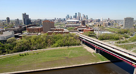
Looking west toward Downtown Minneapolis, late 2016. L to R: former Minneapolis Industrial Expo site and 3rd Ave. Bridge, Riverplace condo tower/Beaucraft building/parking garage/offices framing Our Lady of Lourdes, crane is the “underwhelming” Montage. Pure destruction of Nicollet Island has transformed DeLaSalle’s campus from heavy industrial to bucolic in ¾ of a century. Note the sheer size of the fourth (1974/1990), fork-tongued Hennepin Avenue Bridge (streets.mn streetview from this summer).
Today, 45 years later, that vision has largely been achieved. No longer an industrial wasteland, the Minneapolis riverfront has become a source of civic pride and the focal point of a new residential district attracting people of all ages, from millennials to empty nesters. This population boom, in turn, has helped Minneapolis reverse decades of population loss. According to data provided by the Metropolitan Council, the downtown neighborhoods spanning the river have gained more than 14,000 residents since 2010, accounting for nearly 40 percent of the city’s overall population growth during that time.” — MinnPost retrospective from 2017
These are some astonishing numbers, and that is just the first part of this decade. It is important to note that of these 14,000 new residents, only a few hundred settled in new housing on the actual river, affordable or otherwise. As a result, nearly every damn parcel within a quarter mile on both sides of the central riverfront now has a construction crane on it or a plan to do so soon. The executed vision of Mississippi/Minneapolis has been an exceptional, qualified success! Huzzah! Does this mean we’ve reached The End of History? Hells no.

“Streetscape: Nicollet Island.” Hennepin County Library.
Land Reform
When they talk about the historic nature of the island – hell, if you were going to preserve the historic nature of the island, you would have tenements and business on the island. From the 1930s to the 1970s, until they got moved off, it was hobo land.” — The MPRB’s longtime attorney in 2007.

Unrealized Hennepin Square, East Bank. “Outdoor eating, shopping, art display, band concerts, wading in pool, ice skating, folk dancing, speech making, sitting and people watching.” Mississippi/Minneapolis, 1972.
[dropcap]T[/dropcap]he riposte to my City Pages interview this year was similar to that of last year’s writeup of the Devin for Parks Agenda: bemusement and/or scorn/excitement, reactionary anti-change #concerns, genuine bafflement, or, for some, a deep understanding. If you’re still here some 3,000 words later, I hope you now have the foundation for a deep understanding, too. The other, more typical reactions I described demonstrate that public consciousness is still looking at the riverfront through the lenses and frames of a twentieth century that ended nearly twenty years ago – fitting the idiom to not see Nicollet Island’s forest of opportunity for the few trees we’ve planted there over the years. Remember that a repopulated Nicollet Island is Old Minneapolis!
Do we keep managing a system laid out by visionaries 150 years ago in a reactionary way? Or do we Make No Little Plans‽ The time is right for land reform‡ as nothing less will do! Cities must be the physical and metaphorical front lines developing the resiliency, resources, and justice necessary to adapt and mitigate our increasingly precarious existence. The Long Emergency has arrived at our doorstep. Denying this is amoral.
Due to the size and reach of our parks, Minneapolis offers one of the few conceivable places in urban North America that can undertake genuine, anti-racist land reform on already public property, be it the triangles, Nicollet Island/the riverfront, one of our seven golf courses, or by returning Bdote. The Park Board’s Ecological System Plan has been a great first step in a twenty first century direction. Introducing a human element into this ecosystem analysis of our public land management will lead us a few more steps toward land reform. This means critically considering the past choices and the present course of riverfront redevelopment, and challenging whose histories its future uses will represent.
[dropcap]B[/dropcap]oom Island offers an illustrative example of how to take stock of the present situation and potential future of the human element by looking deeper at our past decisions.

Boom Island (railyard) and north tip of Nicollet Island, 1955. City of Minneapolis.
In the eyes of an enlightened midcentury idealist, the above picture shows a blank canvass on which one can paint a harmonious future, such as in the image below. Later analysis would say these individual buildings represent the greater fabric of our history. Either way, at present, essentially every structure in the above photo has been removed for automobile or park purposes, except, of course, for the historic homes on Nicollet Island.

Boom Island never became housing as intended but instead turned into a gorgeous riverfront park designed by Ted Wirth, grandson of the famous MPRB superintendent. This can be considered an objective Good! We must also consider how that unbuilt dense housing likely ended up as single family homes elsewhere and now increases land costs and development pressures on the rest of the riverfront.
In the meantime Nicollet Island’s iteration of restoration continues, and I wholeheartedly support the current multiyear reforestation plan that begins this October. The possibilities for interpretation are quite exciting, and just as vacant lots are not inevitable neither is car-free utopian development (unless we really try). All I ask for right now is that the Park Board think bigger about the systems it is developing that can objectively measure the value of our environmental assets such as water, trees, and air. What greater role can these tools offer in public decision-making when we introduce the human element?

The 2080 Plan
How could such an island “possibly have lain a foundling for so long on the doorsteps of a great city – and yet again and again and again, when the time for action came, voices faltered, visions faded and doers turned to less controversial projects.” — Scott Russell quoting 1980’s “The Future of Nicollet Island”

[dropcap]T[/dropcap]he 2080 Plan is both a thought exercise and an implementable incremental policy prescription. Consider that essentially the entire course of modern riverfront redevelopment until now is only one third of the way through the 99-year Nicollet Island leases, AND the original Gateway redevelopment was 99 years ago. Futurists use this kind of frame to read present trend lines and extrapolate various (infinite) potential future outcomes. Research like this is how the fossil fuel extraction industry knew in at least in the 1970s precisely how much compounding damage they could inflict on the Earth before it would affect profitability.
There is a major distinction between this kind of qualified research and just making shit up. The Economist suggesting a second international airport as the sort of infrastructure necessary for Minneapolis to adjust to a new century’s climate is plain old Galaxy Brain nonsense. Futurism means proposing an aerial tramway with stops at present and future dense housing developments (say, on golf courses and Nicollet Island) as a way to leapfrog generations of poorly allocated transit investment.
https://streets.mn/2013/02/07/transit-in-the-sky/
[dropcap]T[/dropcap]he 2080 Plan begins by asking what it would look like if Minneapolis used Nicollet Island for Reparations. We could give it back to the nations we stole it from to do as they wish, or we could build an anti-racist no displacement New Town in Town for the Twenty First Century under a car-free job growth/social housing scheme. Either way, there is absolutely no reason in the twenty first century for publicly owned land to be an exclusive wealthy enclave.
This does not mean we use the government’s heavy hand to break the leases it signed in good faith, but to follow the rule of law and issue notices of intended cancellation upon their completion in 2082. The Park Board can deliver these letters now or 40 years from now, but The 2080 Plan suggests now is the fairest timeline for everyone involved. This gives homeowners and institutional interests alike six decades of space to plan for a new century’s needs and truly move on. One step at a time.
To successfully achieve Land Reform in Minneapolis by 2080, we must start now to thoughtfully distinguish between which scales of what kind of incrementalism it will take to lead us there. The below twitter exchange summarizes this difference in the case of Nicollet Island. His initial take on my broad idea of repatriation is to replace a longstanding parking lot with the kind of missing middle incrementalism necessary to help peripheral neighborhoods thrive. My response is the crux of the 2080 Plan: use the unique location of this land to slowly follow our original Big Ideas to completion.

As these historic houses trade ownership over the next generations of the ticking lease clock, the Park Board could deliberately set itself in the position to begin purchasing and moving them onto the south side’s long-unrealized Historic Village Preserve. What happens after that is for the future to decide. One step at a time. The historic parking lot will likely still be waiting.

“Streetscape: Nicollet Island,” 1967. Hennepin County Library.

Same view, 2007.
[ordered_list style=”decimal”]
- The North Service Area master plan is also available for review and comment. Check out the Sepak Tawkra court proposed at Shingle Creek/Olson Middle.
- while suffering through extreme depression and major anxiety. The crucible of campaigning and 2016 election resurfaced long-blocked trauma; answering many questions I didn’t know I had. I came out as non-binary a month before caucuses, the day I figured it out.
- Command economy or bust.
[/ordered_list]
† This begins, of course, with the acknowledgement of the island’s status as stolen and colonized land.
‡ Astonishingly, nobody took umbrage with my calls for Land Reform during the campaign unless it had to do with a particular South Side golf course in need of “saving.” (n.b. I could make the case that this IS possibly the only course worth saving)